
Settings - change map background and toggle additional layers
Filter - control incident types displayed on map.
Zoom to your location
Reset map zoom and position
Could not determine your location.
Show Legend
 Wildfire
 Prescribed Fire
 Burned Area
Response
Burned Area
Response Other
Other
2023 SRF Lightning Complex and Redwood Lightning Complex
Unit Information
Incident Contacts
Campbell Fire Final Update August 15 2023
Related Incident: Campbell Fire
Publication Type: News
Campbell Fire
News - 08/15/2023
Campbell Fire Final Daily Update
August 15, 2023
Size: 8000 acres
Containment: 100%
Start Date: August 11, 2023
Cause: Lightning
Around 4:00 p.m. on August 11, Texas A&M Forest Service received a request for assistance on a fire burning 2 miles North of Olney in Archer County, Texas. The fire is burning in juniper shrub and grass fuels.
After a full operational shift of mop up and patrolling, crews have determined that the Campbell Fire has reached 100% containment and has been handed back over to the local fire departments to monitor over the next few days.
The Florida Gold Team has moved to the Merkel Operations Center to be on standby for the next incident.
Ridge Creek Fire Update for August 16 2023
Related Incident:
Publication Type: News
Ridge Creek Fire
Idaho Panhandle National Forests, Coeur d’Alene River Ranger District
Fire Information: 208-953-7022
Media Information: 989-292-9373
2023.ridgecreek@firenet.gov
https://inciweb.nwcg.gov/incident-information/idipf-ridge-creek
August 16, 2023
Location: Approximately 3.5 miles east of the north tip of Hayden Lake, along the Hayden Creek Road (FSR 437) in the Ridge Creek drainage.
Start Date: 8/3/2023 Cause: Human/Under Investigation Size: 3,124 acres Containment: 15% Total Personnel: 458 Engines: 12 Heavy Equipment: 6 Crews: 11
Given yesterday’s weather, the fire experienced active fire behavior and some fire growth; the acreage of the fire is now estimated at 3,124 acres. Previous efforts to reinforce containment lines served to limit expansion of the fire. Night shift crews will look to use night-time firing operations again to strengthen the east flank of the fire.
To this point on the Ridge Creek Fire, aircraft used to support ground crews have been designated as shared regional resources, meaning that they are allocated to the fire of greatest need at the moment. Yesterday, aircraft were largely directed to respond to the Sarah Loop Fire in support of the Community of Athol, ID. Four Fire Boss fixed-wing scoopers, two Large Airtankers (LAT) and one Very Large Airtanker (VLAT) were readily observable yesterday in the vicinity of Athol and Bayview, ID during the heavy, interagency, initial attack response under the jurisdiction of the Idaho Department of Lands.
Sometime today, the Ridge Creek Fire will receive the services of two ‘super scooper’ air tankers out of Alaska, an additional Type 1 or ‘heavy’ helicopter, and an additional reconnaissance aircraft.
The substantial use of aircraft yesterday should serve as notable reminder that residents and recreational boaters are likely to see either helicopters or fixed-wing aircraft using area lakes. If you are a recreational boater and you observe aircraft using either Lake Hayden or Lake Pend Oreille, you should restrict your activities to the shore area of the lakes.
FIRE STATUS
The Ridge Creek Fire is currently estimated at 3,124 acres and 15% containment, which is reflected on the enclosed maps. Fire crews and heavy equipment operators continue to make progress in reinforcing and strengthening containment lines. To strengthen constructed fuel breaks, crews will look to continue firing operations, as conditions allow, to remove remaining ground fuels. Firing operations were conducted yesterday and last night to take advantage of the moderate conditions that occur overnight. Operations for today will continue the effort to bring a strengthened fireline from the Hudlow Saddle area southward along FSR 406 in the southeast area of the fire. The use of a night shift of engines will continue to be used to patrol the perimeter of the fire to monitor fire behavior. The Hudlow Warming Hut base camp will continue to be staffed to address the southeast area of the fire more efficiently.
Structure assessment staff will likely complete their assessment of homes and structures today in the community of Lakeview on Lake Pend Oreille.
WEATHER AND FIRE BEHAVIOR
We have entered a period of notably hotter and dryer weather that will produce, as it did yesterday, active fire behavior. Wind will predominantly flow from the west and southwest, which will tend to cause fire growth to the northeast. Expect that the fire will produce substantial smoke at times. After cloud cover dissipates and smoke lifts, temperatures will again approach 100 degrees at lower elevations and reach the low-90s at mid-slope elevations. South-facing slopes will feel hotter and dryer. Relative humidity (RH) may fall beneath 20% and may approach the mid-teens throughout the area of the fire this afternoon. Overnight relative humidity recovery will approach 40% at mid-slope elevations. Winds will be light and out of the west to southwest at generally less than 10 mph, with gusts of 15-18 mph at higher elevations. These conditions are conducive to increased fire activity and fire growth. A Fire Weather Watch has been issued by the National Weather Service for the panhandle area of Idaho, which includes the Ridge Creek Fire area (https://www.weather.gov/wrh/fire?wfo=otx&LAT=47.5938&LON=-116.3562).
Be aware that weather conditions today will result in visible smoke. Air quality information is available at www.airnow.gov and www.wildlandfiresmoke.net.
EVACUATION STATUS
The Kootenai County Office of Emergency Management has issued an alert to inform residents of the identification of READY, SET, GO areas in the vicinity of the Bunco Road and Hayden Lake. In this status, residents are cautioned to heighten their awareness of fire information, be familiar with evacuation procedures should it become necessary, and consistently adhere to good fire prevention measures. The Kootenai Office of Emergency Management provides the following direction for residents in these areas designated with a GET READY status: “Please continue to monitor official sources and call 208-446-2292 for any questions regarding evacuations. Follow Kootenai County Emergency Management Facebook Page for updates and sign up for automated Kootenai Alert for emergency alerts. https://www.kcsheriff.com/186/Emergency-Management.”
A map of the revised GET READY areas is included with this update below.
CLOSURES AND SPECIAL MESSAGES
There is a 24-hour per day Temporary Flight Restriction (TFR) in place for the Ridge Creek Fire to prevent incursion of civilian aircraft into the area used by fire-fighting aircraft. This restriction also applies to the use of drones in the TFR area.
Firefighting aircraft are shared resources among numerous fires within the region, including the Ridge Creek Fire. These aircraft will continue to use area waterways, including Hayden Lake, for fire suppression efforts. This means that residents and recreational boaters are likely to see either helicopters or fixed-wing aircraft using the lake. For planes in particular, this requires a long, linear approach and exit from the lake. This restricts their ability to maneuver abruptly should watercraft be within their flight path, creating a serious safety hazard for both boaters and pilots. Pilots that have to deviate to avoid watercraft will also be delayed in acquiring water, inhibiting their fire suppression efforts. All lake users should be on the lookout for approaching aircraft. If firefighting aircraft are in the area, boaters should clear the center of the lake and move toward the shoreline.
The Coeur d’ Alene Dispatch Zone has issued Stage II Fire Restrictions across the Idaho panhandle. The entirety of Kootenai County is within the Stage II Fire Restrictions area. An infographic is included with this update that details the activities that are prohibited under the restriction.
The Idaho Panhandle National Forests issued an emergency closure (Closure Order #01-04-03-23-002) effective August 4, 2023. This Order is for public and firefighter safety due to heavy fire traffic on the area impacted on the Coeur d’Alene River Ranger District, and prohibits all methods of travel (foot, mechanized, motorized and stock) on Forest Service Roads 392, 428A, 437, 1511, 1530, 1552, 1587 and Forest Service Roads 206 and 406 north of their junction, Forest Service Trails 69, 78, 234, and 802 as well as within the described area.
Bedrock and Salmon Fires Daily Update August 16 2023
Related Incident: Bedrock FireSalmon Fire
Publication Type: News
![]()
![]()
Bedrock and Salmon Fires
August 16, 2023
Daily Fire Update
Bedrock Fire Quick Facts
Size: 26,154 acres Origin: Willamette National Forest Resources: 66 engines;
Containment: 20% Cause: Under Investigation 26 crews; *9 helicopters;
Total personnel: 1090 Start Date: July 22, 2023 13 dozers, 34 water tenders
Salmon Fire Quick Facts
Size: 135 acres Origin: Willamette National Forest Resources: 3 engines;
Containment: 95% Cause: Under Investigation 1 crew; 1 water tender;
Total personnel: 37 Start Date: August 6, 2023 *aircraft shared
Community Meeting: There will be a community meeting about the Bedrock and Salmon Fires Thursday, August 17 at 7:30 PM with fire managers and agency representatives. This meeting will be in person at the Pleasant Hill School Community Center.
Bedrock Fire: Firefighters are constructing fire control lines along the western edge of the fire, clearing and improving roads and building dozer line. Yesterday, heavy helicopters flew water buckets to cool the fire while firefighters on the ground continued preparations to defend homes in Big Fall Creek. Firefighters are continuing to hold the fire within established containment lines on the northern, eastern, and southern portions of the fire. Firefighters are patrolling around the fire perimeter, mopping up, securing, and adding depth to control lines.
Salmon Fire: Firefighters are continuing to patrol and monitor around the fire perimeter. There is currently minimal fire behavior.
Evacuations: Level 1, 2, and 3 evacuations remain in place on the Bedrock and Salmon Fires. A searchable evacuation map with fire perimeters is on the Lane County website. There is an evacuation center for people and small pets at the Lowell High School for evacuees from the Bedrock and Lookout Fires. A large animal shelter is being set up at the Lane County Fairgrounds in Eugene.
Smoke: The daily West-Central Oregon Smoke Outlook provides a detailed air quality forecast for the Bedrock and Salmon Fires, as well as other nearby fires.
Weather: The Heat Advisory continues this week through 10 PM Thursday. Temperatures today are forecasted to be 95-100 degrees at lower elevation and 80-86 degrees on the ridges. Winds will begin this morning 3-6 mph, increasing to 8-10 mph this afternoon with gusts to 15 mph on ridgetops.
Safety and Closures: The Willamette National Forest implemented the Bedrock Fire Emergency Area Closure on July 24 to ensure the safety of the public and personnel working on the fire. An emergency closure order for the Salmon Fire area is in place as of August 8. The closure maps for the Bedrock and Salmon Fires are available on InciWeb. There is a Temporary Flight Restriction over the Bedrock Fire area. Residential electrical outages can be reported to Lane Electric at 541-484-1151.
Inciweb Salmon: https://inciweb.wildfire.gov/incident-information/orwif-salmon-fire
Inciweb Bedrock: https://inciweb.nwcg.gov/incident-information/orwif-bedrock-fire
Facebook: https://www.facebook.com/BedrockFire2023/
Fire Information: (541) 414-6272, 8:00 AM – 8:00 PM Email: 2023.bedrock@firenet.gov
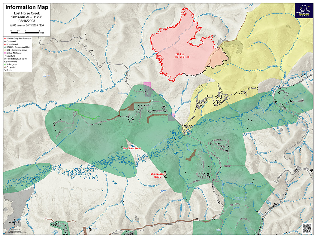
Lost Horse Creek Fire Update Wednesday August 16 2023
Related Incident: Lost Horse Creek Fire
Publication Type: News
Lost Horse Creek Fire Update
August 16, 2023
Incident Commander: Peter Butteri
Start Date: July 28, 2023
ocation: 22 miles N of Fairbanks, AK
Cause: Lightning
Fire Size: 9,505 acres
Containment: 16%
Total Personnel: 369
(Fairbanks, AK) – Crews on the Lost Horse Creek Fire (#296) continue to secure the southern boundary, increasing the amount of containment to 16% (a total of 6 miles). The additional containment came from securing the southeast edge within the 2021 Haystack Fire burn scar. Crews are mopping up the southern edge of the fireline to a depth of 100 feet. The Lassen and Midnight Sun Hotshot Crews are working along the southwest edge, doing a lot of saw work and extinguishing heat in the dozer berms, assisted by the unmanned aircraft and infrared sensors. The Pioneer Peak Hotshots are securing the southwest corner and extending containment line a mile up the west flank. This work is expected to be completed by this weekend.
The line along the southern edge of the fire is being widened and secured. A two-mile-long contingency line was completed west of the fire and a second contingency line was completed southeast of the fire from Haystack toward the Chatanika River.
A weather front coming in Wednesday will likely bring a wetting rain to most of the fire area. Gusty northwest wind and scattered rain is expected for Thursday and Friday.
EVACUATIONS: The Haystack subdivision remains at a Level 2 (SET). Residents are advised to remain vigilant and be prepared to evacuate if necessary. For more information: Fairbanks North Star Borough, AK | Official Website (fnsb.gov); Find My Neighborhood (arcgis.com)
CLOSURES: Alaska State Parks has closed the Olnes Pond campground to support fire operations. The BLM Eastern Interior Field Office issued an evacuation and closure order for the western portion of the White Mountains National Recreation Area. See: Alaska Fire Restrictions | Bureau of Land Management (blm.gov).
AIR QUALITY ADVISORY: Any community adjacent to an active fire may experience periods of degraded air quality. For smoke forecast and air quality measures, see Fire and Smoke Map (airnow.gov).
TEMPORARY FLIGHT RESTRICTIONS (TFR) are in effect until September 9, 2023. For details, see: 3/4417 NOTAM Details (faa.gov).
Public Information: (907) 921- 2555
Media Inquiries: (907) 921- 2554
Email: 2023.LostHorseCreek@firenet.gov
You Tube: www.youtube.com/AlaskaDNRDOF
www.akfireinfo.com
www.facebook.com/AK.Forestry
inciweb.wildfire.gov/
Anderson Complex Daily Update for Wednesday Aug 16 2023
Related Incident: Anderson Complex
Publication Type: News
ANDERSON COMPLEX DAILY FIRE UPDATE | Wednesday, Aug. 16, 2023
![]()
Anderson Complex Fire Information
Phone: (907) 921-2553 (8 a.m. to 8 p.m.)
Email: 2023.andersoncomplex@firenet.gov
Anderson Complex crews work to reduce fire suppression impacts
Firefighters assigned to the Anderson Complex are now working on separate but equally important assignments. Some continue to protect structures and allotments that are still threatened by fire. Others have been tasked with reducing the environmental impacts of fire suppression in areas that are no longer at risk.
The Shores Landing Fire (#325) continues to be active along the edges of the perimeter. A Blackhawk helicopter was used again yesterday to drop water on hotspots. Despite the flare ups, the fire still has not seen any significant growth. Crews expect to be finished in the next 48 hours with a project to create defensible space around an allotment northeast of the fire.
Crews in the area of the Teklanika River Fire (#257) are maintaining pumps, hoses and sprinklers set up to protect structures. They are also felling trees that have been damaged by fire to improve safety for firefighters and the public. Mop up of any remaining hotspots is also underway.
Crews in the City of Anderson completed their suppression repair work yesterday. Firefighters in the North Forties and Kobe Ag subdivisions are engaged in suppression repair today as well with support from heavy equipment operators.
Suppression repair is a critical part of wildland firefighting. It involves a number of post-fire measures designed to return fire lines, staging areas, helipads and other areas used by firefighters to as natural a state as is practicable. The primary goal is to minimize any further damage due to erosion.
Firefighters across the complex continue to remove pumps, hoses, and sprinklers that are no longer needed. Firefighting equipment that is still protecting threatened structures is not being removed.
The Anderson Complex includes the Teklanika River Fire (#257), Birch Creek Fire (#285), Shores Landing Fire (#325), Rock Creek Fire (#287), Bear Creek Fire (#287), Kobe Road Fire (#297), Nenana River Fire (#288), and Nenana River 2 Fire (#289). The fires have a combined acreage of 58,933 acres.
WEATHER: There is an increased chance for rain and the possibility of thunderstorms today. Temperatures will be in the mid to upper 60s with winds mostly from the northwest at 5-10 mph. Relative humidity will be higher. Minimal fire behavior is expected.
EVACUATIONS: The Teklanika River and all residents along the Teklanika River remain in evacuation status GO. Individuals in this area should evacuate now. Do not delay. The Tri-Valley School is available for evacuation parking and will be available as an evacuation center, if needed.
The Rose Hip Creek area and Clear Sky homestead are in evacuation status SET. Individuals in this area should be ready to evacuate at a moment’s notice if necessary. Those re-entering burned areas should be aware of possible hazards, including fire-damaged trees, ash pits, smoldering stumps or logs, and the potential for flash flooding. Firefighters will still be in the area. Please give them room to work.
The City of Anderson, the North Forties subdivision, and Kobe Ag subdivision are in evacuation status READY. Individuals in this area should remain ready for possible evacuation.
Visit the Denali Borough website for additional information.
CLOSURE: The City of Anderson has closed the shooting range until further notice for firefighter and public safety. Firefighters are working in the area for the next several days. The campground and playground are open.
Pogo Mine Road 191 Mount Hayes 299 Fires Update 8162023
Related Incident: Pogo Mine Road FireMount Hayes Fire
Publication Type: News
WILDFIRE UPDATE - Delta Area Pogo Mine Road Fire (#191) & Mount Hayes Fire (#299)
Wednesday - August 16, 2023
Rain arrives in Delta, Firefighters going direct
Rain finally arrived in the Delta area in place of warm and dry weather. Active surface fire with single tree torching was observed Tuesday, but the overnight and morning rain reduced fire behavior to creeping and smoldering. Firefighters engaged in protecting structures and securing the southwest corner of the Pogo Mine Road Fire by working directly on the fire’s edge. The Mount Hayes Fire has remained in the same footprint for more than a week with minimal fire activity observed.
Pogo Mine Road Fire (#191) – 48,888 acres | 106 personnel | 12 miles NW of Delta
A road group has been established to cut and remove fire-weakened trees along Pogo Mine Road to ensure continued, uninterrupted operations of the mine and firefighter safety. Ten smokejumpers are assessing defensible space and structure protection needs for cabins along the south, southeast perimeter of the fire. Chena Hotshots are cutting sawline and directly mopping up the fire’s edge near the pipeline and winter trail. Tongass Fire Suppression Module is mopping up areas of heat near the Alyeska Pipeline. Tanana Chiefs Conference Crew and Arroyo Grande Hotshots are in place for both structure protection and mop up.
Mount Hayes Fire (#299) – 7,085 acres | 90 personnel | 7 miles SE of Deltana
This wildfire has not spread for more than one week and is currently being monitored by air. Sierra Hotshots are implementing cabin protection for three public-use cabins located east of the Gerstle River and owned by Alaska Fish and Game. Resources remain in place on the dozer line designated to keep the fire from moving north to the Alaska Highway.
Weather: A weather front moved over the Alaska Range and the fire area Wednesday, which brought a wetting rain to the fire. High pressure is expected to cause west winds of 10 to 15 mph from late Wednesday into Thursday and bring drying conditions for Thursday and Friday. A significant chance of rain is forecasted for Friday night and Saturday.
A Temporary Flight Restriction is in place for the fires, pilots please check NOTAMs.
Fire Information: Phone number: 541-977-2756 / Fire Info website: AkFireInfo.com
Facebook: AK.Forestry / Twitter: @AK_Forestry / YouTube: AlaskaDNRDOF
Gravel Pit Fire Daily Update Wednesday August 16 2023
Related Incident:
Publication Type: News
Gravel Pit Fire Daily Update
Montana Department of Natural Resources and Conservation, Northwest Land Office
WESTERN MONTANA ALL HAZARDS IMT │ INCIDENT COMMANDER: KEN PARKS
https://inciweb.wildfire.gov/incident-information/mtmts-gravel-pit-fire
2023.gravelpit@firenet.gov (406) 247-0514
Wednesday, August 16, 2023 at 10:00 a.m.
Location: 25 miles southeast of Libby, near Silver Butte
Start Date: 8/1/23 Cause: Human Size: 304 acres Containment: 76%
Total Personnel: 80 Engines: 7 Tenders: 1 Hand Crews: 2
SPECIAL WEATHER MESSAGE
The National Weather Service has issued a Heat Advisory from noon on Tuesday through midnight on Thursday in much of northwest Montana, including the fire area, with valley temperatures of 105°F possible.
The National Weather Service has also issued a Fire Weather Watch from noon Thursday through 10:00 p.m. on Thursday in much of western Montana. Fires will start easily, intensify rapidly, and spread quickly. Eliminate human-caused fire starts.
CURRENT STATUS
Yesterday, fire crews looked for and extinguished sources of heat, working in a grid pattern through green islands within the fire perimeter. Crews continued to backhaul hose that is no longer necessary, but left hose in place where sources of heat remain. An excavator was utilized to dig through dozer line berms to expose and extinguish hot spots.
PLANNED ACTIONS
With the Heat Advisory in effect, heat-related injuries are a prime concern. To mitigate this, crews will perform the most physical aspects of their work in the morning. Today, crews will continue to work in a grid pattern to locate sources of heat within the fire perimeter and extinguish them. With internal flare-ups occurring, ember wash can produce spot fires outside of the fireline. To address this, engines will patrol the fire area and seek out any sources of heat. Engines and crews will remain ready for initial attack and respond to new fire starts in the area.
WEATHER AND FIRE BEHAVIOR
Hot, dry, windy conditions will dominate northwest Montana on Wednesday and Thursday. Expect temperatures in the upper 90s to low 100s, low teens to single-digit relative humidity values, and poor overnight RH recoveries and wind gusts from 20-25 mph over the next two days.
Fire behavior is low, with smoldering and creeping, but the potential exists for more active fire behavior with the hot, dry weather pattern over the next three days.
EVACUATIONS AND CLOSURES
There are no evacuation warnings, evacuations, or closures currently in effect. All Lincoln County residents are encouraged to sign up for emergency alerts by downloading the Code Red application and entering contact information. Code Red is the primary notification system to alert residents of evacuations.
Lookout Fire Morning Update 8162023
Related Incident: Lookout Fire
Publication Type: News
Lookout Fire
August 16, 2023
Morning Update
Size: 3,710
Start Date: August 5, 2023
Point of origin: 3 miles North of McKenzie Bridge, OR
Cause: Lightning
Total personnel: 584
Resources: 47 engines l 9 crews l 9 bulldozers l 18 water tenders l 4 masticators l 4 helicopters
OSFM Resources: 8 task forces
Current Situation: The Lookout Fire has moved north toward Lookout Creek but has not crossed it. Strategic firing operations on Forest Service Road 700 were successful and the fire is still north of the road. Heavy smoke moderated temperatures and fire activity yesterday. Smoky conditions are expected today with the possibility of lifting with west winds. If smoke clears, fire activity has the potential to increase.
Oregon State Fire Marshal (OSFM) resources were joined by one California Office of Emergency Services (Cal-OES) task force yesterday, bringing the total number of structural task forces operating on the fire to eight. Task forces continued surface preparation, triage of structures, and conducted overnight patrols along the 700 road to monitor the fire. Crews also completed preparations on the HJ Andrews Forest Compound, including sprinkler installations and vegetation clearing.
Today’s activities: Crews will be working to connect primary control lines in the west using heavy machinery to improve roads and by digging hand line. Firefighters will be securing the 700 road by extinguishing hot spots where firing operations occurred. Crews have been preparing control lines in the north and are almost complete with this work. To the east crews are prepared for west winds and ready to engage the fire if smoke clears increasing activity. In the southeast firefighter personnel are strategizing on places to utilize firing operations to slow fire growth and secure the southern containment lines.
Today OSFM crews will continue preparations on structures, including Belknap Bridge. Task forces will continue to support wildland resources as needed.
COMMUNITY MEETING: Thursday, August 17, 2023, 6:30-7:30 p.m., In-person at McKenzie High School, 51187 Blue River Dr, Vida, OR 97488 and virtually on Facebook.
Evacuation Centers: There is an evacuation center for people and small pets at the Lowell High School for evacuees from the Bedrock and Lookout Fires. A large animal shelter is being set up at the Lane County Fairgrounds in Eugene.
Evacuations: There is a Level 3 (GO NOW) evacuation notice for
- Taylor Road
- North Bank Road
- All areas north of Highway 126 between Blue River Reservoir Road and Drury Lane
- Mona Campground
- Lookout Campground
- HJ Andrews Experimental Forest headquarters
There is a Level 1 (Be Ready) evacuation notice for
- Areas south of Highway 126 from Blue River Reservoir Road east to Foley Ridge Road
- McKenzie River Drive
For current information please see Lane County’s website at: https://www.lanecountyor.gov/cms/one.aspx?pageId=19729054
Weather: Smoke has the possibility of lifting today with west winds 5-10 mph. A possibility of thunderstorms.
Closures: Highway 126 is currently open please monitor Trip check for any updates https://tripcheck.com/. Willamette National Forest closures can be found at: https://www.fs.usda.gov/detail/willamette/alerts-notices/?cid=fseprd552029
Restrictions: Fire Restrictions are in place on the Willamette National Forest https://www.fs.usda.gov/willamette
Smoke Outlook: August 16-17 - Heavy smoke has drifted into Central Oregon overnight. HAZARDOUS air quality is being seen in Sisters and VERY UNHEALTHY to UNHEALTHY levels in the Redmond and Bend areas. McKenzie and areas closer to the fire will continue to see high smoke impacts in the UNHEALTHY to HAZARDOUS ranges. The Willamette Valley is seeing improving conditions with only light smoke impacts expected. A slight chance for thunderstorm activity may create short term significant changes in smoke impacts. https://outlooks.wildlandfiresmoke.net/outlook/4c92bc1a?
Information Line: 541-215-6735 8am-8pm | Email: 2023.lookout@firenet.gov
Facebook: https://www.facebook.com/LookoutFire2023
Inciweb: https://inciweb.nwcg.gov/incident-information/orwif-lookout-fire
Sourdough Fire Update August 16 2023
Related Incident:
Publication Type: News
Resources: 383 Total Personnel | 5 Hand Crews | 20 Engines | 5 Water Tenders | 7 Helicopters
(Newhalem, Wash.) -- The Sourdough Fire started with a lightning strike on July 29 near Diablo in the steep and rugged terrain of Ross Lake National Recreation Area, 7 miles northeast of Newhalem. An infrared flight was unavailable to provide an updated acreage and containment percentage. Despite challenging conditions, firefighters have continued to make progress in achieving several objectives, such as ensuring community safety by preventing the fire from spreading into critical infrastructure.
Yesterday: Moderate fire activity was observed due to prevailing weather conditions and the dissipation of an inversion layer, leading to the formation of a column potentially visible to nearby communities. Most of the recent growth occurred along the northwest perimeter, particularly near the Camp Dayo and Jeanita drainages, where there is little threat to the public or structures. Helicopter water drops on the eastern edge near Sourdough Creek effectively cooled and slowed fire growth. On the eastern, southern, and western fronts, crews continued efforts to safeguard local communities and values at risk. Aerial resources tracked the fire’s intended progression toward the 2015 Goodell burn scar. During the night, crews utilized Unmanned Aircraft Systems (UAS) for burning operations focused on eliminating fuel between the fire’s edge and the 2015 Goodell burn scar.
In a collaborative effort, fire personnel responded to a new incident named the Blue Lake Fire, situated approximately 30 miles east on Highway 20, near Blue Lake on the Okanogan-Wenatchee National Forest. The Sourdough Fire team provided support to address this emergent situation, supplying additional aerial resources and skilled rappelers for the initial attack efforts.
Today: Implementing hose lays and fuel reduction measures continue near structures, along power lines and road areas near the southwest portion of the fire. Where safe to do so, firefighters are actively engaged in mopping up areas along the State Route 20 corridor. While ground crews continue to diligently work, aerial resources are closely monitoring the fire. Due to limited visibility resulting from dense smoke yesterday, a key focus today will be reconnaissance of the fire’s movement, especially assessing the more active regions of Jeanita Lake and upper Sourdough Creek. Aircraft with water dropping capabilities will be used in the steep terrain of the Sourdough Creek drainage to impede fire growth to the east. Helicopters and a UAS will monitor fire progression toward the 2015 Goodell burn scar and assist in further fuel removal operations.
Weather: The Red Flag Warning has been extended through tonight due to hot, dry, and unstable weather conditions. Temperatures are expected to cool into the weekend with a cold front moving into the area; winds are expected to persist.
Safety: Fire danger is still extremely high. The public can help prevent the next wildland fire by observing outdoor burning bans and avoiding other common ignition causes.
Smoke: Smoke from the Sourdough Fire may affect communities around the region. Information about current conditions and a smoke forecast is located at: https://wasmoke.blogspot.com.
Although the Sourdough Fire’s smoke has not significantly impacted most areas, you can prepare for wildfire smoke. For information go to: https://www.cdc.gov/disasters/wildfires/smoke.html and https://www.wildlandfiresmoke.net/smoke-ready
Closures and Evacuations: State Route 20 remains closed between milepost 120 (Newhalem) and milepost 146 (just east of the East Creek Trailhead). Trail, area and camp closures are in effect, for more information,
go to: https://www.nps.gov/noca/planyourvisit/fire- closures.htm