
Black Feather Fire Daily Update August 17 2023
Related Incident: Black Feather Fire
Publication Type: News
The Northern New Mexico Type 3 Incident Management Team Assumes Command of the Black Feather Fire
Acres: 2,198 acres
Start Date: August 5, 2023
Cause: Lightning
Fuels: Timber, Brush, Understory
Containment: 28%
Resources: 380 personnel
Location: Approximately 9 miles south of Gallina, NM, on the Santa Fe National Forest, Coyote Ranger District. Near the Peñas Negras Trail in the San Pedro Parks Wilderness.
Highlights: Today, at 7:00 a.m., Northern New Mexico Type 3 Incident Management Team, led by Incident Commander Steven Griego, assumed command of The Black Feather Fire from The Southwest Area Incident Management Team 2 (SWAIMT2), who has been managing the incident since Monday, August 9. The management teams met yesterday to begin the formal transition and review the strategic response and protection plan in place for the fire. Incident objectives continue to include firefighter and public safety, as well as protecting property, infrastructure, and other values at risk, including timber and watershed.
Operations: Today, firefighters will focus on suppression-repair efforts and improvement of containment lines, including continuing to tie together hand and dozer lines with area roads. Crews are working closely with Resource Advisors (READs) on recommendations to help ensure the protection of critical areas and significant natural and cultural resources. Grader work on the 103 Road and chipping throughout the area will continue. Firefighters will continue to utilize the infrared drone to identify and mop up any hot spots.
Safety: Expect increased personnel in the area and on local roads as firefighters and equipment move to new locations. Please stay out of the fire area to allow crews safe access to the fire. A Temporary Flight Restriction is in place around the fire area. Please do not fly drones anywhere near the fire. If you fly, we can’t fly.
Weather: Scattered showers and thunderstorms brought wildly variable amounts of rainfall to the fire area, ranging from no measurable rain to over half an inch. This pattern is expected to continue into the late week, with high temperatures around 80 degrees and relative humidity falling to the 30s. Scattered showers and storms are still expected to pop up daily in the afternoons and evenings, though they may be increasingly restricted to higher ground as moisture modestly decreases.
Restrictions/Closures: The Santa Fe National Forest has issued an area, road, and trail closure in part of the Coyote Ranger District. See https://www.fs.usda.gov/alerts/santafe/alerts-notices/?aid=82412 for information and a corresponding map. Forest Road 103 is closed to non-residential traffic. Closures will be adjusted based on fire activity.
Smoke: Variations in temperatures and humidity in the coming days and weeks will impact smoke conditions. Smoke may be more and less visible in the area as active smoldering takes place. Smoke-sensitive individuals and people with respiratory problems or heart disease are encouraged to take precautionary measures. Air quality information is available at https://www.airnow.gov/
Evacuations: The communities of Mesa Pinabetal, Mesa Poleo, and Wetherill remain in ‘Ready’ status. The Coyote Senior Center is open to evacuees, and livestock can be taken to the Rio Arriba Rural Event Center near Abiquiu. The Rio Arriba County Sheriff’s Office will coordinate evacuations if they go into effect. For more information, use the QR code below and visit the Sheriff’s Office Facebook page: https://www.facebook.com/profile.php?id=100079688263048
Fire Information: 505-460-0499 – 2023.blackfeather@firenet.gov
Facebook: https://www.facebook.com/blackfeatherfireinfo
New Mexico Fire Information: https://nmfireinfo.com/
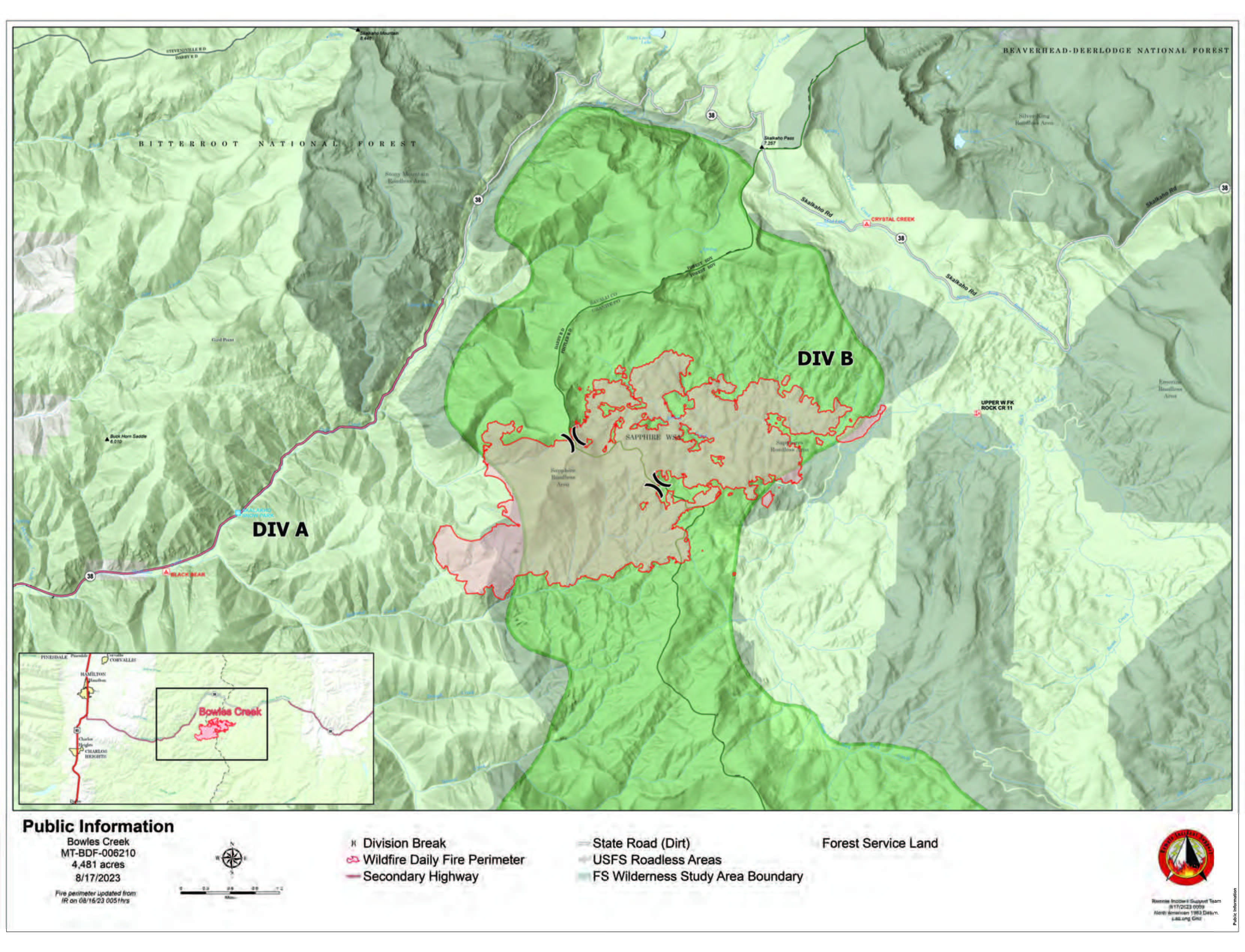
Bowles Creek Fire Update August 17 2023
Related Incident: Bowles Creek Fire
Publication Type: News
Smoke from the Bowles Creek Fire continues to impact local communities, especially along Hwy 38, Skalkaho Road. Hwy 38 remains open. However, motorists are urged to drive slowly and with caution as heavy fire operations are occurring along the entirety of the roadway. Additionally, smoke from the fire settles more heavily at night, so drivers are urged to remain extra vigilant if traveling through the area after sunset. In light of potential changing fire conditions, it is recommended to check for updated information on road and area closures prior to traveling. Updates can be found on Inciweb or the Bowles Creek Fire Facebook page. If road access changes, a news release/update will be released by the Incident Management Team.
The area is experiencing its 9th day of drying conditions. Larger fuels are drying with more live surface fuel availability. Fire activity is picking up and will continue over the next few days. Flanking, group tree torching, and spotting is being observed. Fire crews continue to construct fuel breaks along several roads. Aircraft is checking fire spread and fire officials continue to monitor fire behavior. Firefighters are utilizing firing operations to strengthen containment lines. Fire crews also continue to implement chipping and mastication operations, as well as installation of sprinklers, to reduce available fuels near values at risk.
Bear Creek Fire Daily Update Thursday August 17
Related Incident: Bear Creek Fire
Publication Type: News
Bear Creek Fire start date:
August 1, 2023
Mosca Fire start date:
August 7, 2023
Location: 23 miles Northwest of Pagosa Springs, Colorado
Cause: Lightning
Incident Commander:
Jay Kurth
Management Team:
NIMO Team 1
Management: Suppression
Fire size today:
Bear Creek: 415 acres
Mosca: 8 acres
Containment:
Bear Creek: 0%
Mosca: 90%
Personnel:
Bear Creek: 106
Mosca: 27
Evacuation Information:
Weminuche Valley is under pre-evacuation notice. Local residents should follow incident information and updates.
losures:
- Cloman Park in Pagosa Springs
- https://tinyurl.com/trails-and-roads
Latest Smoke Outlook:
outlooks.wildlandfiresmoke.net/outlook/933fc4e4
INCIDENT OBJECTIVES:
- Firefighter and Public safety are the highest priority.
- Protect private lands within the Weminuche Creek drainages, natural resources, cultural and historic sites, recreation assets and critical infrastructure including powerlines and gas utility lines.
A Multi-Mission Aircraft flight to obtain updated acreage for the Bear Creek and Mosca wildfires was not available today due to heavy rainfall in the area. The increase of the Mosca Fire acreage was due to more accurate GPS mapping on the ground.
Bear Creek Wildfire: Firefighters have been unable to directly engage the fire due to the steep remote terrain and heavy fuel loading of dead standing and down trees. The clearing of vegetation along the Weminuche Trail and mastication of vegetation along the Mosca Road continued. The fire received localized thunderstorms and wetting rain yesterday. Very little smoke will be seen from the fire today.
Mosca Wildfire: This wildfire is burning remains in existing footprint in a remote area northwest of Bear Creek near Slide Mountain in steep terrain. There has been little active heat or movement on this fire. The Pike Hot Shot Crew has been building handline and mopping up in hopes of full containment on Friday morning.
YESTERDAY’S ACCOMPLISHMENTS:
- Pike hotshots completed all of the handline around the Mosca wildfire.
- Fire managers continued to use two masticators on the Mosca Road to the south of the fire to reduce fuels and to create a contingency line.
- Crews in the Weminuche Valley area assessed risk level to private land/structures and developed and implemented structure protection plans.
TODAY’S PLAN:
- Continue fuels mitigation along the Mosca Road corridor with masticators.
- Continue to widen the fuel break along the Weminuche Trail by reducing the density of vegetation.
- Operational supervisors will continue scouting indirect control opportunities to the south along the Mosca Road, connecting that into the Weminuche Valley.
- Pike hotshots on the Mosca Fire will work to complete the handline and mop up the remaining hot spots.
WEATHER:
Monsoonal moisture is likely in the afternoons. Temperatures will continue to rise for the next several days, possibly into the mid-80s by the end of the week. The humidity and wind levels may pick up in afternoons, but not reach red flag wind warning levels.
Incident Information: https://tinyurl.com/mrx4pp27
Facebook: https://tinyurl.com/mr2tpj69
Email : 2023.bearcreek@firenet.gov Information Line : 970-426-5370
Quartz Ridge Fire Daily Update Thursday August 17
Related Incident: Quartz Ridge Fire
Publication Type: News
Fire start date: August 5, 2023
Cause: Lightning
Location: 13 miles Northeast of Pagosa Springs, Colorado
Incident Commander:
Jay Kurth
Management Team:
NIMO Team 1
Management: Suppression
Fire size today: 1,475 acres
Containment: 0%
Personnel: 137
Evacuation Information:
There are no current evacuations. Local residents should follow incident information for updates.
Closures:
- Quartz Meadows Rd (NFSR#685)
- Quartz Ridge Trail (NFST#570)
- Quartz Creek Trail (NFST#571)
- https://tinyurl.com/roads-and-trails
Latest Smoke Outlook: https://outlooks.wildlandfiresmoke. net/outlook/933fc4e4
INCIDENT OBJECTIVES:
- Firefighter and Public safety are the highest priority.
- Protect private lands within East Fork San Juan River drainage, natural resources, cultural and historic sites, recreation assets, and critical infrastructure including powerlines and gas utility lines.
The wildfire is burning in steep terrain in the South San Juan Wilderness. Indirect suppression tactics are being utilized as the preferred and safest approach since significant (almost 90%) tree mortality exists, creating a high potential for burning snags and falling trees.
A Multi-Mission Aircraft flight indicated there was still some hot spots on the eastern side of the Quartz Ridge Fire, but overall the fire is fairly cool. Fire behavior is predicted to be minimal over the next few days. Potentially by the weekend we will see the fire slowly start to become a little more active and see more smoke as the weather warms and dries.
YESTERDAY’S ACCOMPLISHMENTS:
- Brushing of the East Fork Road was completed.
- Continued to evaluate terrain and potential areas for containment outside of wilderness boundaries and scout for strategic areas for control.
TODAY’S PLAN:
- Chipping of the slash along the East Fork Road.
- Orient the San Juan hotshots as they transition to the fire.
- Scout the eastern edge of the fire and look for opportunities for direct fireline construction.
- Crews will be hiking in on the trails to work on widening the trails and reducing fuel loading..
- Continue to build structure protection plans both logistically and operationally.
WEATHER:
Monsoonal moisture is likely in the afternoons. Temperatures will continue to rise for the next several days, possibly into the mid-80s by the end of the week. The humidity and wind levels may pick up in afternoons, but not reach red flag wind warning levels.
Incident Information : https://tinyurl.com/mr37bhnr
Facebook : https://tinyurl.com/y87cycm4
Email : 2023.quartzridge@firenet.gov Information Line : 970-426-5370
Klamath National Forest Lightning Fires Update Aug 16 2023
Related Incident:
Publication Type: News
Acting Public Affairs Officer: Janine Summy
(530) 643-0279
KlamathNFPublicAffairs@gmail.com
Klamath National Forest Lightning Fires
August 16, 2023
Type 1 Incident Management Team In-briefed this Evening
YREKA, Calif., August 16, 2023— A series of thunderstorms moved across the Klamath National Forest Monday night, bringing abundant lightning and igniting roughly 20 fires over the western side of the forest. Scattered precipitation was received with these storms. More lightning is forecasted throughout the week, and additional new fires are anticipated due to the volume of lightning received.
The most active of these fires is the Head Fire, which is burning at the confluence of the Klamath and Scott rivers. The fire was fanned by strong winds from thunderstorms that developed in the area and burned actively throughout Tuesday afternoon, growing to 3,500 acres by nightfall. Firefighters worked through the night, focusing on point protection of residences in the area. Fire behavior moderated overnight but increased with the heat of the day.
Evacuation Orders and Warnings are in effect for the area and road closures are in place for on CA Highway-96 and the Scott River Road. Current information on evacuation status can be found at https://www.facebook.com/SiskiyouCountySheriff and through alerts issued by CodeRED.
Happy Camp/Oak Knoll Ranger District
The Happy Camp/Oak Knoll Ranger District has reported 11 fires. The largest of these is the 50- acre Elliott Fire, which is burning on both sides of Elliott Creek near Dillon Creek Campground. It is zero percent contained. The Malone Fire is 20 acres and located up Elk Creek. Resources are on scene. The 15-acre Titus Fire south of Norcross Campground received significant moisture overnight and has minimal fire behavior. Four fires -the Swillup, Brown, Dutch, and Intersections – are all less than an acre and are contained. Four additional fires have been reported, all of which are less than one acre – the Berry Fire near Huckleberry Mountain, the Indy Fire near Independence Creek and near the border of the Marble Mountain Wilderness, the Three Creeks Fire and the Canyon Fire are both near the Elliott Fire.
Salmon/Scott River Ranger District
On the Salmon/Scott River Ranger District there are eight fires. The Scott Fire is roughly 16 acres and is located near the Scott Bar Lookout with crews on scene working to contain it. Two fires – the Boulder Fire near Indian Scotty Campground and the Hossick Fire near Scott Bar- are contained. Two fires are burning in the Sky High Lakes area of the Marble Mountain Wilderness. The Shadow and Lake Fires are staffed with helitack and smokejumpers, respectively. Both are less than 2 acres. The Townsend Fire is 5 acres with difficult access up Townsend Gulch off of the Lake Mountain Lookout Road. The Block Fire is near the Townsend Fire; no size has been reported and both Townsend Gulch and Block Fires are unstaffed. The most recently reported fire on the Salmon/Scott District is the Gold Fire, which is across the drainage from the Scott Fire. It is not yet staffed.
More lighting is in the forecast for today with Red Flag Warnings in effect for abundant lighting on dry fuels. Thunderstorms also have the potential to emit strong down draft winds which can cause existing fires to increase fire behavior significantly.
Multiple aircraft and other additional resources have been ordered for these fires. CAL FIRE’s Siskiyou Unit is also providing assistance. Additional resources have been requested to support suppression operations.
Forest Supervisor, Rachel Smith adds, “We are proud and appreciative of all our emergency responders and are very concerned about ongoing conditions for large fire development. If you are asked to leave your house, please evacuate immediately.”
A Type 1 Incident Management Team (Mueller’s California Interagency Incident Management Team 5), in-briefed at 6:00 p.m. tonight.
Evacuation Orders and Warnings remain in effect. Fire activity picked up in the afternoon when the inversion lifted. Highway 96 and the Scott River Road have hard closures. Please continue to monitor CodeRED and the @SiskiyouCountySheriff for current information.
The Pacific Crest Trail is closed from Etna Summit to the Oregon border. Hikers and backpackers are asked to stay off the trails in that area.
The public can help support firefighters by preventing human-caused fires. Practice extreme vigilance with anything that can start a wildfire. Fire restrictions are in effect on the Klamath National Forest, which prohibits all campfires outside of developed campgrounds.
Remember, one less spark equals one less wildfire.
Additional information on Klamath National Forest lightning fires can be viewed on Inciweb: https://inciweb.nwcg.gov/incident-information/caknf-2023-klamath-nationalforest- august-lightning-fires
The Klamath National Forest covers 1,700,000 acres located in Siskiyou County, California and Jackson County, Oregon. The forest is headquartered in Yreka, CA, and maintains ranger stations in the California communities of Macdoel, Happy Camp, and Fort Jones. More information is available at www.fs.usda.gov/klamath.
Follow us www.facebook.com/KlamathNF
Twitter @KlamathNF
USDA is an equal opportunity provider, employer, and lender.
Slide 1 Fire Update Aug 16 800 pm
Related Incident: 2023 Slide 1
Publication Type: News
WILLOWS, Calif., Aug. 16, 2023 — The Slide 1 Fire, which is located approximately 1.5 miles north of Mt. Linn in the Yolla Bolly Middle Eel Wilderness, has grown slightly today to an estimated 320 acres.
All assigned resources remain on scene. Today initial attack crews hiked to the fire’s edge and had opportunity to work on a direct fire line. Though firefighters are making progress, containment on the Slide 1 Fire remains at 0%.
Access to the fire’s edge is quite challenging and requires strenuous hiking through steep, rugged country. Excessive heat is also taking its toll on firefighters, and two heat-related medical incidents occurred today.
Incident managers have requested additional support including a type-3 helicopter, type-1 initial attack hotshot crews, fire-line qualified medics and resource advisors. A falling crew is also on scene.
The weather forecast shows active potential for thunderstorms over the next several days.
Agency administrators expect a portion of the Yolly Bolly Middle Eel Wilderness on the Grindstone Ranger District to close to the public in the coming days.
Yesterday there were 156 lightning strikes on the forest. Last night an engine and initial attack crew responded to the Pebble Fire, which is located near Pine Mountain on the Upper Lake Ranger District. The Pebble Fire is contained at .32 acres and in patrol status.
Also today, smokejumpers and a hotshot crew responded to a lightning fire in the Sanhedrin Wilderness near Impassable Rock and west of Big Signal Peak, now called the Rock Fire. Fire personnel have requested additional jumpers and air attack as the fire is burning in steep terrain with heavy fuels. The Rock Fire is currently at one acre.
The Hole Fire on the Covelo Ranger District was contained yesterday and remains in patrol status.
Additional information about the Slide 1 Fire and other lightning-related fires will be posted to Inciweb at https://inciweb.wildfire.gov/incident-information/camnf-2023-slide-1.
Slide 1 Fire Update Aug 16 1100 am
Related Incident: 2023 Slide 1
Publication Type: News
WILLOWS, Calif., Aug. 16, 2023 — The Slide 1 Fire, which is located approximately 1.5 miles north of Mt. Linn in the Yolla Bolly Middle Eel Wilderness, grew overnight to 285 acres. Fire behavior is active and expected to increase later in the day as chances of thunderstorms and gusty winds increase.
The strategy for the fire is full suppression and aggressive extended attack to minimize the number of large wildfire incidents. The location of the fire in the wilderness area presents several hazards for firefighters, including hazard trees from past wildfires and remote, rugged terrain.
Several fire resources are on scene including seven smokejumpers, a type-1 initial attack hand crew, air attack, one air tanker and two type-2 on-call crews. Additional resources are ordered, including a type-3 helicopter, a type-2 helicopter, falling crews and six type-1 or type-2 initial attack crews.
The fire is located north of private property owned by the timber company Crane Mills, and there is a private inholding within in the wilderness area in the vicinity of the fire. CAL-FIRE Tehama Glenn Unit is working to prep any structures or private lands that are threatened.
Additional smokes are being reported on the forest after more lightning strikes yesterday. Fire personnel are out patrolling, and the forest is ordering additional resources to assist the districts, including a strike team of engines and water tenders, falling crews and wilderness resource specialists.
Forest leadership is planning to issue a closure order for the Ides Cove Area later today.
Smoke may be visible later today from the I-5 corridor from Willows to Red Bluff.
Incident information will be posted to Inciweb later today, and another update on the Slide 1 Fire will be issued this evening.
Lightning sparks several fires including the Slide 1 Fire at 60 acres
Related Incident: 2023 Slide 1
Publication Type: News
WILLOWS, Calif., Aug. 15, 2023 — Fire personnel on the Mendocino National Forest are responding to lightning fire starts after thunderstorms passed through yesterday. On the Grindstone Ranger District two fire starts called Slide 1 and Slide 2 occurred near Slides Ridge, approximately 1.5 miles north of Mt. Linn in the Yolla Bolly Middle Eel Wilderness. The two incidents merged, and the incident is now being called the Slide 1 Fire.
The Slide 1 Fire is at 60 acres, according to the latest report from fire personnel. The fire is burning in timber and brush and has potential for moderate to high rate of spread in rugged, steep terrain. The fire is within the 2020 August Complex footprint. Fire managers are using a full suppression strategy.
Current resources assigned to the Slide 1 Fire for initial attack include seven smokejumpers, one air attack, one air tanker, three engines and two type-2 on-call crews. The air tanker has dropped retardant.
Resources to support initial attack are en route including three engines and a task force engine. Fire managers have also ordered additional resources for tomorrow, including six type-1 or type-2 initial attack crews, four falling crews, two type-2 helicopters, one air attack and two air tankers.
Also today firefighters on the Covelo Ranger District responded to a lighting start called the Hole Fire, which is located near the Hell Hole Creek. The Hole Fire is contained and in patrol status at.1 acres.
A red flag warning is in effect through 10 p.m. tonight given the increased potential for lightning on dry fuels. The forecast shows periodic thunderstorms throughout the week.
More information on the Slide 1 Fire will be provided in the morning or as it becomes available.
Little Mesa Fire Update August 16 2023 730PM
Related Incident: Little Mesa Fire
Publication Type: News
Little Mesa Fire Evening Update - August 16, 2023
Firefighters continue making progress to secure the fire perimeter. No new growth on fire. Today's smoke was due to continued cleaning up unburned pockets of fuel for resource benefit. The excavator was busy repairing mastication lines and working on roads.
For updated information follow on these outlets:
Inciweb: https://inciweb.wildfire.gov/incident-information/coupd-little-mesa-fire
Facebook: @LittleMesaFire Twitter: @SWD_Fire
Afternoon Fire Update 81623
Related Incident: 2023 SRF Lightning Complex and Redwood Lightning Complex
Publication Type: News
Hoopa, CA – As of Wednesday afternoon, August 16, the Lone Pine Fire had grown to approximately 400 acres with
0 percent containment. Of the 23 confirmed fires burning within the Six Rivers National Forest following recent
lightning activity, the Lone Pine Fire is one of several top priority fires. The fire is burning between the Horse Linto
Creek and Tish Tang Creek drainages and east of the Trinity River.
The fire is currently being managed by the North Coast Incident Management Team 3 (IMT3) and the Six Rivers National
Forest (SRNF). The fire is under a full suppression tactic. Firefighters are creating a handline and heavy equipment are creating dozer lines near Tish Tang Ridge. A firing operation is expected to strengthen lines on the west side of the fire within the next 48 hours.
Because the fire has burned over the Hoopa Valley Indian Reservation’s southern border, the North Coast Incident
Management Team 3 and SRNF is working in close coordination with the Hoopa Valley Tribal Council and Hoopa Fire
Department to prioritize protection of tribal resources and cultural sites.
There are currently no evacuation advisories, warnings, or orders associated with the Lone Pine Fire, however, Hoopa
Fire Department Chief Greg Moon said that the necessary tools are in place should an evacuation be necessary.
“Even though the fire has burned onto the reservation, there are currently no structures threatened,” Moon said.
“Our teams are meeting regularly and have plans in place to protect the community.”
There are currently 150 fire personnel assigned to the fire; 3 handcrews, 5 engines, 1 dozer, 2 water tenders and 55
overhead staff. Additionally resources have been ordered and are in route.
The Hoopa Fire Department is also expecting additional resources from the Bureau of Indian Affairs, Tule River Fire,
Chumash Fire, Quartz Valley Fire and the Nature Conservancy, to help with initial attack of this fire and any additional
potential fires.
A red flag warning due to excessive heat and northwest winds remains in effect through 9pm tonight.
There is currently a forest closure on the Hoopa Valley Indian Reservation at Tish Tang Road and Sign Board Gap. No
additional road or forest closures are in effect at this time.
Official information regarding the Lone Pine Fire will be provided by the Hoopa Fire Department and Office of
Emergency Services and Six Rivers National Forest. In addition, KIDE 91.3 FM will broadcast updates daily. Maps and
updates will also be posted at https://inciweb.nwcg.gov/incident-information/casrf-lone-pine-fire
Residents are encouraged to download the “Genasys” application on their smartphones, or visit https://app.zonehaven.
com to stay informed about potential threats, advisories, warnings and orders.