
Emergencyresponseteamsharessoilburnseverity map and research from Lookout Fire
Related Incident: Lookout Fire
Publication Type: Announcement
Emergency response team shares soil-burn severity map and research from Lookout Fire
Field surveys, satellite images provide a picture of burned areas and soil stability
Springfield, Ore. – Oct. 5, 2023 — Today, an Emergency Response Team of resource specialists released their findings on the Lookout Fire, Horse Creek, and Pothole fires burned areas, following field surveys and assessments.
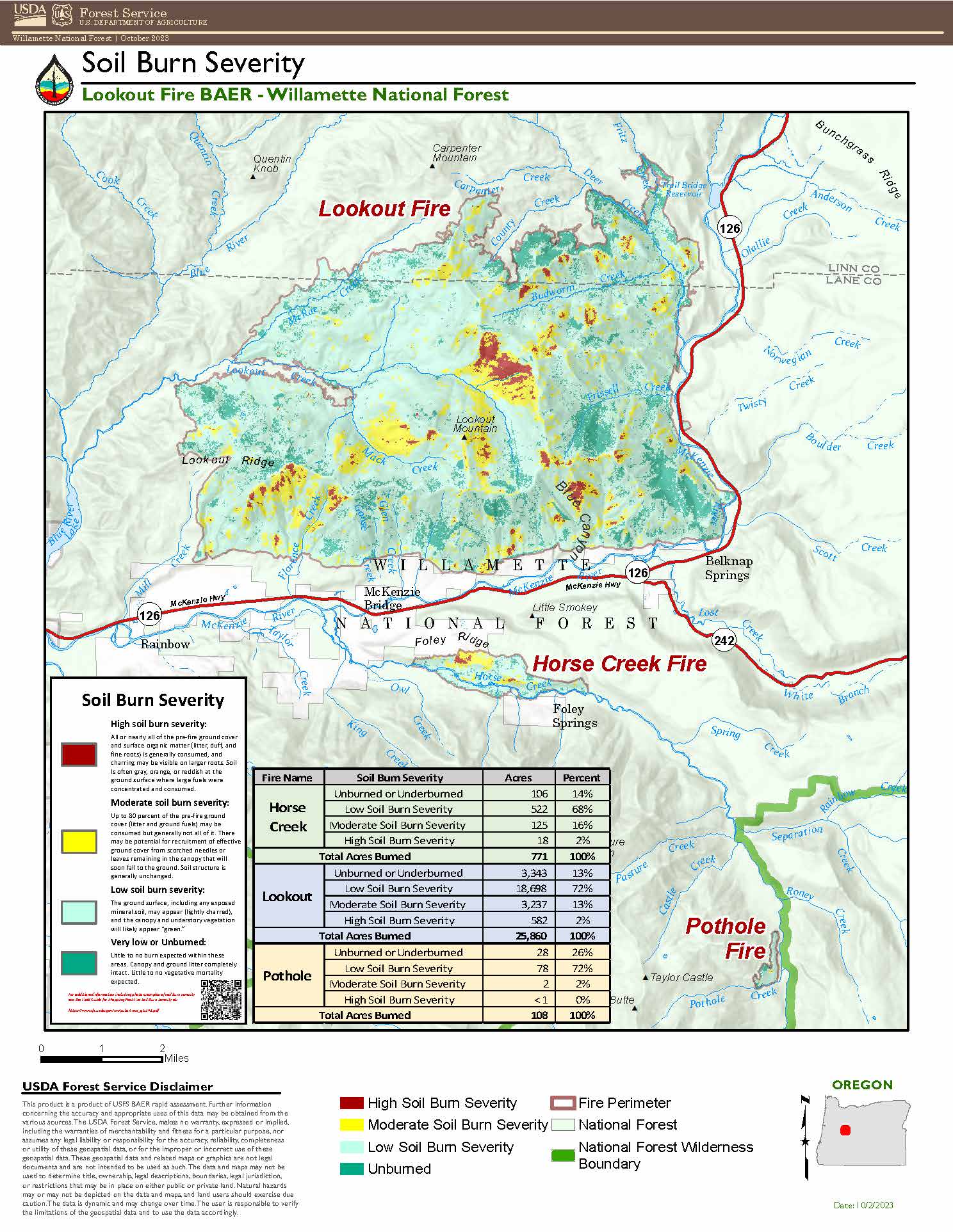
The Burned Area Emergency Response (BAER) Team is an Emergency Response program aimed at managing imminent, unacceptable risks to human life, safety and property, as well as threats to critical natural and cultural resources, from post-wildfire conditions. BAER Team members closely assess watersheds for post-fire, rain-related impact, such as flooding, debris-flow potential, and increased soil erosion. The team then recommends time-critical treatments to complete before the first damaging storm event and creates a soil burn severity map for the fires.
The Lookout Fire map identifies 2 percent of the fire area as having high burn severity and 13 percent with moderate burn severity. The remaining 85 percent has low or unburned/underburned severity. For the Horse Creek Fire, the map identifies 2 percent of the fire as high burn severity, 16 percent as moderate burn severity and the remaining 82 percent as low or unburned/underburned severity. Finally, the Pothole Fire area had zero percent high burn severity, 2 percent moderate and the remaining 98 percent as low or unburned/underburned severity.
A soil burn severity map is generated using satellite imagery and validated and adjusted by field surveys, which the BAER team wrapped up this week. The team observed roots below the soil surface were generally unburned and providing soil stability, water able to infiltrate into the soil at deeper depths, and soil structure was not degraded.
“With the majority of these three fire areas experiencing moderate to low soil burn severity, we would expect limited erosion, flooding and risk for debris flows in the coming months,” said BAER Team Leader Wendy Peterman. “Areas with steeper, burned hillslopes that lack ground cover remain at risk of slides and erosion until the vegetation recovers.”
In areas with moderate to high burn severity on steep slopes, the team focused on identifying protection measures for values at risk including developed recreation sites, roads, historic and cultural sites.
High burn severity is evidenced by the consumption of all ground cover and surface organic matter (litter, duff, fine roots), sometimes leaving a layer of ash several inches deep. The higher the burn severity, the less likely soil can absorb rainfall, increasing surface runoff and risk of erosion, debris flows, and flooding. Moderate burn severity areas will have up to 80 percent ground cover consumed, however soil structure is generally unchanged. In areas with low burn severity, the ground often appears lightly charred.
The BAER team is now prioritizing values at risk and developing a suite of emergency actions to mitigate potential hazards. BAER proposals focus on federal lands, but the team will be sharing information about identified hazards with other agencies later this week to help them plan for potential problems. The soil burn severity map is available for viewing and downloading at: https://inciweb.nwcg.gov/incident-information/orwif- lookout-fire
For more information regarding this BAER assessment, please contact Kassidy Kern at (541) 588-2000 or Kassidy.kern@usda.gov.
Follow us on Facebook and Twitter @WillametteNF for more updates.

Oct 5 Prescribed Fire in Valle Vidal Tentatively Scheduled
Related Incident:
Publication Type: News
Carson National Forest personnel are preparing to potentially start the McCrystal Rock Prescribed Fire in Valle Vidal late next week. Crews could begin ignitions on the 6,333-acre project as early as Oct. 12, but the timing will ultimately be based on weather and on-site conditions in consultation with a meteorologist.
“We’ve been looking for opportunities to start this project, not just when the weather and conditions allow, but in between the once-in-a-lifetime elk hunts in Valle Vidal, Unit 55A,” said Questa District Ranger Adam LaDell, referring to New Mexico’s hunting program. “I can’t guarantee this will perfectly fit between hunts, but we are certainly trying our best.”
McCrystal Campground will remain open, but visitors will likely experience smoke and see an increase in fire personnel presence during operations. It is recommended to use the nearby Cimarron Campground.
The McCrystal Rock Unit is part of the larger 21,000-acre Valle Vidal Northeast Prescribed Fire Project. The goal is to improve wildlife habitat by, in part, promoting grassland and meadow regeneration and reducing the potential for high-severity wildfires in forested areas.
Fire crews have used prescribed fire to treat most of the project area in recent years, including a 1,694-acre unit in 2016 and a 2,000-acre unit in 2009. The 2002 Ponil Complex Fire burn area is also within the unit and the 2017 Whitman Fire is adjacent.
Fire-adapted forests in the Southwest must undergo fire disturbance on a regular basis to maintain resiliency. Reintroducing and maintaining regular fire intervals in the Valle Vidal, the so-called “Yellowstone of the Southwest,” is a key component of the USDA Forest Service’s Wildfire Crisis Strategy. The emphasis of the strategy is to increase fuels and forest health treatments to protect natural resources in designated landscapes, including the 1.5-million-acre Enchanted Circle Landscape in Northern New Mexico.
Smoke from the prescribed fire could impact Valle Vidal and may be noticeable to communities in Colfax County, New Mexico, and Las Animas County, Colorado.
The public can get prescribed fire updates on InciWeb, New Mexico Fire Information and Carson National Forest social media channels (Facebook, X).
Quarry Fire Daily Update Oct 5
Related Incident: 2023-STF-Quarry Fire
Publication Type: Announcement
Quarry Fire Update
Wednesday, October 4th, 2023
Stanislaus National Forest
Incident Management Team (Type-3)
PIO Contacts: Eugenie Moore - eugenie.moore@usda.gov
steve lyon - slyon@nps.gov
Fire Statistics:
Location: The Quarry Fire is located on the Stanislaus National Forest, Mi-Wok Ranger District, off Forest Road 3N01, east of Bourland Creek and near the Emigrant Wilderness west of Cherry Creek.
Acres Burned to Date: 5,557
Cause: Lightning
Containment: 13.5%
Total Personnel: 121
Injuries: 0
Background: The Quarry fire was one of 42 fires ignited by lightning strikes across the forest on September 9, 2023. District fire managers immediately worked to ensure these naturally ignited fires stayed within pre-determined boundaries. Fire personnel with the Stanislaus National Forest are currently managing the Quarry Fire to achieve multiple resource objectives.
Current Activities: No fire movement today due to recent moisture. Crews made improvements to holding lines, including using natural features such as granite outcroppings to improve effectiveness, in anticipation of further fire spread later this week when weather and fuel moisture improves.
Fire professionals are managing fire behavior and intensity to provide for multiple resource benefits including reducing concentrations of all fuels, re-establishing multigenerational timber stands, improving wildlife habitat, promoting plant diversity, and re-introducing fire into fire adapted ecosystems.
Closures: Soft closures are in effect to provide for the safety of the public utilizing public lands as well as fire personnel working in the area. The soft closures are an encouragement for the public to stay clear of the area, to find alternate routes to their locations and to provide fire personnel the widest berth possible as they go about their mission.
With the public’s cooperation, we will continue to monitor the number and duration of each, recognizing that fire personnel and public safety is the focus.
As of October 4, 2023, the following soft closures are in effect:
2N71 where it meets 3N16
3N21 where it meets 3N16
3N21 where it meets 3N01
3N22 where it meets 3N01
3N34Y
3N01H
3N01J
3N01L
3N16
3N29 to 3N29C
3N17 where it meets 3N29
Smoke: Smoke impacts from the Quarry Fire, the prescribed burns of the Experimental Forest, Dry Meadows and Beardsley Burn units on the Summit Ranger District will cause smoke to settle in low lying areas. Check out the fire and smoke map at fire.airnow.gov for more information.
More Information:
INCIWEB - Quarry Fire Info - https://inciweb.wildfire.gov/incident-information/castf-2023stfquarry-fire
Stanislaus National Forest – Official Website - https://www.fs.usda.gov/stanislaus
Magic Feather Prescribed Burn could resume as early as October 7 2023
Related Incident: Magic Feather Prescribed Burn
Publication Type: News
FORT COLLINS, Colo. (Oct. 5, 2023) – Firefighters on the Roosevelt National Forest’s Canyon Lakes Ranger District are closely monitoring local conditions to resume prescribed fire operations on the Magic Feather Prescribed Burn near Red Feather Lakes as soon as October 7, 2023.
The burn is located east and southeast of Red Feather Lakes. This project is a continuation of burning that took place in July when 553 acres were successfully burned. Burning operations will occur throughout the fall as conditions allow and will include six units totaling approximately 5,000 acres, located north and south of County Road 74E (Red Feather Lakes Road).
Appropriate, localized conditions must be met before ignition of prescribed burns can take place. Fire managers have been carefully monitoring these conditions, including favorable weather forecast (temperature, wind, precipitation, relative humidity), fuel moisture, smoke dispersal and staffing. Weather is monitored throughout the burn and burning is halted if conditions fall outside of the required conditions.
Expect to see increased activity in the Mount Margaret, Molly Lake, Elkhorn and Lady Moon area while firefighters are prepping and burning within the project area. These trail systems will be closed during operations.
People in the surrounding area should expect to see smoke when operations are taking place. Smoke may also impact those using the Dowdy Lake Campgrounds and Day-Use Area. Prescribed fire smoke may affect your health. For more information about the potential health impacts of smoke, visit Colorado Department of Public Health and Environment.
Even with the most thorough planning and preparation, the use of prescribed fire carries an innate level of risk that cannot be eliminated entirely. However, prescribed fire is one of the most efficient ways of reducing wildfire risk. Regularly conducting prescribed fires, which mimic nature, reduces the buildup of flammable vegetation and overgrowth.
This prescribed burn is part of the overall strategy on the Arapaho and Roosevelt National Forests to address the Wildfire Crisis. Prescribed fire is one of the most efficient ways of reducing wildfire risk. Regularly conducting prescribed fires, which mimic nature, reduces the buildup of flammable vegetation and overgrowth.
To receive updates, follow us on Facebook and Twitter and join our email list through Constant Contact and select list "Forest Health & Fire: North of Hwy 14 to Wyoming Border (Red Feather Lakes)." Additional information may be found on Inciweb
Morning Update Thursday October 5 2023
Related Incident: Bedrock FireLookout FirePetes Lake Fire2023 Horse Creek Fire
Publication Type: News
Lookout, Bedrock, Petes Lake, Horse Creek and Pothole Fires
Thursday, October 5, 2023 - Morning Update – 9:00 a.m.
Lookout Fire - Size: 25,751 acres | Start Date: August 5 | Cause: Lightning | Containment: 60%
Bedrock Fire - Size: 31,590 acres | Start Date: July 22 l Cause: Under Investigation l Containment: 100%
Petes Lake Fire - Size: 3,254 acres | Start Date: August 25 | Cause: Lightning | Completion: 80%
Horse Creek Fire - Size: 763 acres | Start Date: August 24 | Cause: Lightning | Containment: 100%
Pothole Fire - Size: 109 acres | Start Date: August 25 | Cause: Lightning | Containment: 100%
Total Assigned Personnel: 339 | 8 engines | 5 crews | 2 dozers | 3 water tenders | 1 masticator | 1 helicopter
(Walterville, Ore.) – With temperatures increasing as the weekend approaches, smoke may become visible around the Lookout Fire area as fire inside the perimeter becomes more active. Drier conditions will allow for heavy equipment to regain access to work areas after rain-slicked roads earlier in the week hampered efforts. The helicopter base, located near Sunriver, has been decommissioned but aerial resources will continue to stage locally. Crews will finalize work on the Horse Creek Fire today with efforts on the Bedrock Fire projected to finish soon. Most resources are assigned to the Lookout Fire, where the bulk of work remains. Structure protection equipment removal on the Lookout Fire is complete.
Suppression repair efforts remain a key focus of the incident’s resolution, aiding in the recovery of the forest and reducing the risk of future fires. Repair work across the Lookout Fire includes chipping and the removal of woody debris, drainage and erosion control as well as hand and dozer line improvement.
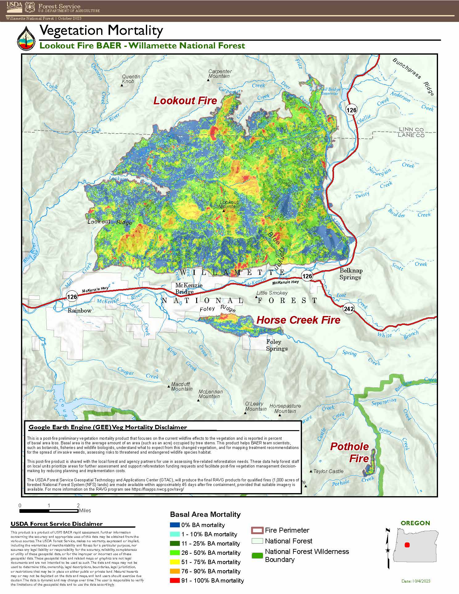
Burned Area Emergency Rehabilitation (BAER): This will be the last update for the Burned Area Emergency Response (BAER) effort. The team has finalized its soil burn severity and vegetation mortality maps for the Lookout, Horse Creek and Pothole Fires. The overwhelming majority (80% and above) of the three fire areas experienced low to moderate burn severity. In areas with moderate to high burn severity on steep slopes, the team focused on identifying protection measures for values at risk including developed recreation sites, roads, historic and cultural sites. The final assessment and maps can be found on Inciweb.
Weather: The warming and drying trend will continue into the weekend. Unseasonably high temperatures and low relative humidity are predicted. Breezy east winds will extend through Friday morning but are expected to stay below critical levels.
Forest Closures: Established closures on the Willamette National Forest remain in place around fire-impacted areas, including the Lookout and Bedrock Fires. The public is urged to “Know Before You Go” by visiting the Willamette National Forest official webpage. For specific hunting-related questions, contact Oregon Department of Fish and Wildlife at (503) 947-6000.
Safety: Some fire-impacted areas remain closed as critical suppression repair work continues. The public is asked to exercise caution along roadways around the fire. Drivers should be extra vigilant along Forest Road 15 between Highway 126 and Highway 20, where crews and heavy equipment are traveling and engaging in suppression repair work.
Informacin actual para los incendios Anvil y Flat 5 de octubre 2023
Related Incident: Anvil FireFlat Fire
Publication Type: News
Incendio Anvil
Área: 22,170 acres Fecha de inicio: 25 de agosto, 2023 Localizado: 8 millas Este de Port Orford, OR
Contenido: 54% Personal: 962 Recursos: 22 escuadrillas de bomberos, 7 helicópteros, 25 camiones de bomberos
El día de ayer, las escuadrillas de bomberos no lograron entrar en el eje Oeste de la línea del incendio. Esta área aún no está contenida debido a los vientos que han limitado el acceso de los helicópteros transportando a los bomberos. Los bomberos lograron realizar parte del trabajo en un 50% de la parte inferior de la sección ya mencionada. Las escuadrillas de bomberos se encuentran removiendo las bombas de agua y mangueras alrededor de las casas de Elk River Road. Las bombas de agua permanecerán organizadas como una manera de precaución para los residentes. Las operaciones de astillado continúan realizándose a lo largo de Sixes River Road. Se han desarrollado los planes para crear más distancia entre el eje Este y los valores en riesgo de la comunidad. El trabajo de astillado sobre la mitad de la zona más al Sur del incendio se movilizará hacia el lado Sur de la carretera y continuará trabajando, dirigiéndose hacia el Oeste. Al comienzo de esta semana, el eje Este del incendio ha estado bajo un monitoreo y se ha beneficiado por la presencia de lluvias y las temperaturas mas bajas.
Evacuaciones: La Oficina del Alguacil para el Condado de curry, creo zonas de evacuación cerca del Incendio Anvil; Zonas 1, 2 y 4 se encuentran en un Nivel 2 “LISTOS”, la Zona 3 se encuentra en un Nivel de evacuación 1 “PREPARESE”. Las condiciones climáticas podrían cambiar rápidamente. Por favor, este atento a la información actualizada. Para revisar un mapa interactivo de evacuación, visite: https://bit.ly/AnvilEvacs. Puede registrarse en el sistema de Alertas de emergencias para el condado: https://bit.ly/CurryCoEM
Incendio Flat
Área: 34,242 acres Inicio:15 de agosto, 2023 Localizado: 2 millas Sureste de Agness, OR
Contención: 93% Personal: 51 Recursos: 3 camiones de bomberos, 1 escuadrilla de bomberos.
Se encuentran trabajando arduamente con un excavador y una maquina astilladora en la reparación de supresión sobre la punta Norte moviéndose hacia el Este. Las escuadrillas de bomberos que realizan el trabajo a mano están siguiendo la maquinaria para remover arboles peligrosos y completar cualquier trabajo adicional que sea necesario.
Las áreas para Emergencia de Incendio y las Ordenes de Cierre de Carreteras aún se encuentran en efecto: Permanece en pie la Orden de Cierre para los incendios Anvil y Flat. La reciente precipitación a través del bosque ha permitido levantar las Restricciones de Uso Público, permitiendo el uso de fogatas en áreas en donde el bosque no se encuentra bajo Ordenes de Cierre. Tenga en cuenta que esta Orden referida a fogatas, no elimina la Orden de Cierre de caminos. El personal forestal se encuentra trabajando de manera cercana con los manejadores del incendio en la evaluación de medidas de cierre y buscando el momento oportuno para levantarlas tan pronto como sea posible para los bomberos y para el público en general. Existe una información actualizada para Área de Emergencias y Ordenes de cierre de caminos para el incendio Flat, en los cuales se encuentra la reducción de cierres y las carreteras adyacentes que han sido reabiertas en el área del incendio. La orden de Carretera más reciente se dio en efecto el 3 de octubre, 2023 y rescinde el 31 de diciembre, 2023, a menos que sea anulada antes de esa fecha. Puede encontrar mapas e información más detallada en: https://bit.ly/RRSNFAlerts o https://inciweb.wildfire.gov/incident-closures/orrsf-anvil-fire
Puede encontrar información actualizad y mapas al respecto en: https://bit.ly/RRSNFAlerts o https://inciweb.wildfire.gov/incident-closures/orrsf-anvil-fire.
Restricciones: El Bosque Nacional de Rogue River Siskiyou, levanto todas las Restricciones en las tierras del bosque para uso del público, moviendo el Nivel de Peligro de Incendio a “Bajo” y reduciendo el Nivel de Precaución de Incendios a Nivel 1.
Condiciones climáticas: El día de hoy será soleado con temperaturas de 80 grados en algunas áreas del incendio y menos intensidad del viento que en el día de ayer.
Condiciones del humo: Se podrá ver la presencia del humo de vez en cuando durante el día. Para información actualizada en cuanto a la presencia del humo y la calidad del aire, visite: https://bit.ly/SWORsmoke. Por favor conduzca despacio y con las luces encendidas a través de cualquier área de incendio.
Carreteras: Visite www.tripcheck.com o llame 511 para información al día acerca de cierres de carreteras. Por favor no utilice las carreteras forestales como una ruta alternativa.
Líneas Informativas: (541) 216-4579 o (541) 237-6369
Email: 2023.anvil@firenet.gov
Facebook: facebook.com/flatfireoregon2023
X/Twitter: twitter.com/RRSNF
Inciweb Anvil Fire: bit.ly/AnvilFireOR
Inciweb Flat Fire: bit.ly/FlatFireOR
Anvil and Flat Fires Update October 5 2023
Related Incident: Flat FireAnvil Fire
Publication Type: News
Anvil Fire
Size: 22,170 acres Start Date: August 25, 2023 Location: 8 miles east of Port Orford, OR
Containment: 54% Total personnel: 962 Resources: 22 crews, 7 helicopters, 25 engines
Firefighters were unable to access the uncontained section of the western edge of line yesterday due to windy conditions which limited helicopter capabilities to transport firefighters. Progress was made on the lower half of this section. Crews are removing pumps and hose around homes on Elk River Road, and staging this equipment as a precaution for residents. Suppression repair continues to take place around the fire. Chipping operations continue along Sixes River Road. Plans to create more separation between the east edge and values at risk are being developed. Chipping work on the southern half of the fire will switch to the south side of the road and begin working back to the west. The eastern edge of the fire is being monitored and benefited from the rain and cooler temperatures early in the week.
Evacuations: Curry County Sheriff’s Office has identified evacuation zones near the Anvil Fire: Zones 1, 2, and 4 are in Level 2 “Set” status. Zone 3 is in Level 1 “Ready” status. Conditions may change quickly. Monitor for updates in evacuation levels. View the interactive evacuation map at https://bit.ly/AnvilEvacs. Sign up for Curry Co. emergency alerts at https://bit.ly/CurryCoEM.
Flat Fire
Size: 34,242 acres Start Date: July 15, 2023 Location: 2 miles southeast of Agness, OR Containment: 93% Total personnel: 51 Resources: 1 crew, 3 engines
An excavator and chipper are working on suppression repair on the northern tip working east. Crews are following the equipment to remove hazard trees and complete any additional work by hand.
Emergency Fire Area and Road Closures Still in Effect: Forest closures remain in place in both fire areas. Recent precipitation across the forest allowed for the lifting of Public Use Restrictions, which allows campfires on areas of the forest that are not currently under a closure order. Lifting Public Use Restrictions for campfires does not rescind closure orders. Forest staff are working closely with fire managers daily to re-evaluate closures and look for opportunities to reopen them as soon as safely possible for both firefighters and the public. There is an update to the Emergency Area and Road Closure for the Flat Fire, reducing the closure area and reopening roads adjacent to the fire area. The new order is effective October 3, 2023 through December 31, 2023 unless rescinded sooner.
For current closure information and maps, please visit: https://bit.ly/RRSNFAlerts or https://inciweb.wildfire.gov/incident-closures/orrsf-anvil-fire.
Fire Restrictions: The Rogue River-Siskiyou National Forest lifted all Public Use Restrictions on Forest Service lands and moved to “low” fire danger today. The Industrial Fire Precaution Level was reduced to Level 1.
Weather: Today will be sunny with temperatures in the low 80's on some areas of the fire and much less windy than yesterday.
Smoke: Smoke may be visible at times. For current smoke and air quality updates visit, https://bit.ly/SWORsmoke . Please drive slowly and with headlights on through any fire area.
Roads: Visit www.tripcheck.com or call 511 for current road closures. Do not use forest roads for alternate routes.
Contact Fire Information: (541) 216-4579 or (541) 237-6369
Email: 2023.anvil@firenet.gov
Facebook: facebook.com/flatfireoregon2023
X/Twitter: twitter.com/RRSNF
Inciweb Anvil Fire: bit.ly/AnvilFireOR
Inciweb Flat Fire: bit.ly/FlatFireOR
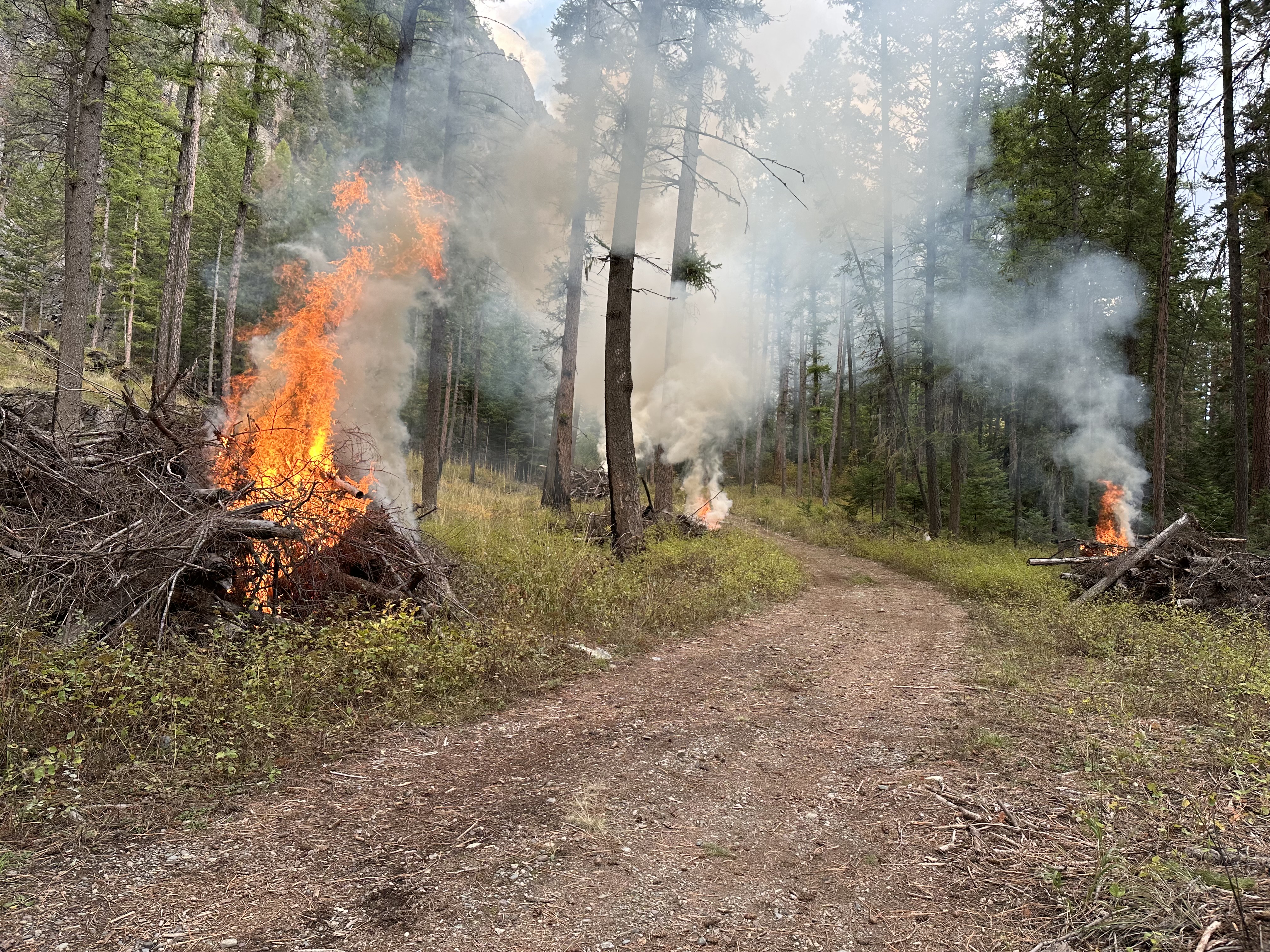
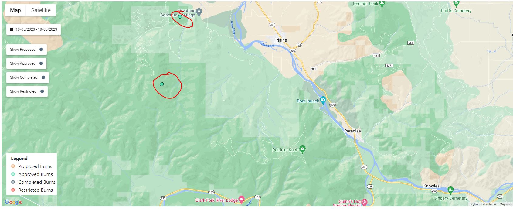
October 5 2023 Pile Burn Update
Related Incident: Lolo National Forest Prescribed Fire Operations
Publication Type: Announcement
Pending favorable conditions, firefighters on the Lolo National Forest are planning to conduct pile burns today to reduce hazardous fuels from previous vegetation management operations.
Plains/Thompson Falls Ranger District:
18 firefighters plan to burn several piles on two different units located 5 miles west of Plains, MT near Sheep Creek and East Fork Swamp Creek. Residents in Plains may see residual smoke this evening into tomorrow. Firefighters will continue to monitor the area during and after the burn.
Happy Camp Complex PostFire BAER Assessment Summary Released
Related Incident: 2023 Happy Camp Complex BAER Assessment
Publication Type: Announcement
Happy Camp Complex Post-Fire BAER Assessment Summary Released
Attached below under Related Information is a summary (PDF document) of the Klamath National Forest's Burned Area Emergency Response (BAER) team's post-fire assessment of the Happy Camp Complex burned areas.