
Quartz Ridge and Bear Creek Fires Update100423
Related Incident: Quartz Ridge FireBear Creek Fire
Publication Type: News
QUARTZ RIDGE & BEAR CREEK FIRES
Update: October 4, 2023
Type 4 Team, Incident Commander: Alex Farinetti
This will be the FINAL regular Update on the Quartz Ridge and Bear Creek fires.
Overview:
On October 3, Alex Farinetti’s Type 4 team assumed command of the Quartz Ridge Fire and the Bear Creek Fire.
The new smaller organization is comprised of a wildfire module that will continue to patrol both fire areas, with spotters watching for any increase in fire activity. The team will use location-specific weather forecasting information and infrared heat detection data to help carry out its strategy. It will also have access to aerial resources should they be needed.
Both fires are located in steep, remote terrain that poses a significant safety risk to firefighters. There has been very little growth from either fire in recent weeks, and only minimal smoke output. Recent precipitation has further dampened fire activity. If conditions were to change and more aggressive fire behavior were to develop, firefighters have strategies in place to take more aggressive actions.
Quartz Ridge Fire: 2,850 acres | The fire is located in steep, remote terrain in the San Juan Wilderness, 13 miles northeast of Pagosa Springs. It received nearly ¾ of an inch of rain over a 36-hour period starting October 1. There is very little heat, all within the current perimeter.
Bear Creek Fire: 1,094 acres | Nearly 1 inch of rain fell on the fire between October 1st and 2nd. There have been a few small, isolated areas of heat and smoke in the northern section of the fire, but no smoke has been visible since the rainfall. Structure protection equipment remains in place at homes and ranch properties in the northern section of the Weminuche Valley, and will remain there until fire managers conclude there is no potential threat of the fire coming down into the valley.
Weather:
As mentioned, significant rainfall fell on both fires between October first and second. The weather for the later part of the week is going to be dry and cool, with high temperatures in the 55-65 degree range Wednesday and Thursday.
San Juan NF Temporary Closures: In the Quartz Creek Fire area, the Quartz Creek Trail (NFST#571) remains closed. In the Bear Creek Fire area, Little Sand Trail (NFST #591) and Shaw Creek Trail (NFST#584) are closed. For more info: Quartz Ridge Closure and Bear Creek Closure.
Prescribed Fire: There has been increased smoke production this week caused by prescribed burning in locations on the San Juan National Forest. For the most up to date and detailed information, visit https://inciweb.nwcg.gov/incident-maps-gallery/cosjf-san-juan-national-forest-prescribed-fire-program
Daily Update Wednesday October 4 2023
Related Incident: Tiger Island FireLions Camp Road FireElizabeth Fire
Publication Type: News
Transition to the Florida State Incident Management Green Team
Tonight at 7 p.m., the Florida State Incident Management Green Team will take command of the Tiger Island, Hwy. 113, Lions Camp Road and Elizabeth Fires. Debbie Beard, incident commander for the Southern Area Complex Incident Management Gold Team Incident, thanks parish authorities and departments, sheriff’s offices, the Governor’s Office of Homeland Security and Emergency Preparedness, and the public for their support during the last two weeks.
Fire Highlights
Yesterday, fire behavior inside the fires’ footprint was minimal again. On the Tiger Island, Hwy.113, Elizabeth and Lions Camp Road Fires, crews patrolled containment lines, looked for heat signatures identified during infrared flights, and mopped up hot spots. They also continued to clear needle cast from containment lines to prevent reignition. On the Hwy. 113 and Elizabeth Fires, firefighters continued to identify heat sources within the 10-mile Creek Drainage.
Today, crews will continue to patrol containment lines for heat sources that could initiate reburning of vegetation, as well as mop up and patrol containment lines. Resources will be available to assist the state with initial attack resources as needed. Timber salvage operations continue to make progress on the Tiger Island and Lions Camp Road Fires.
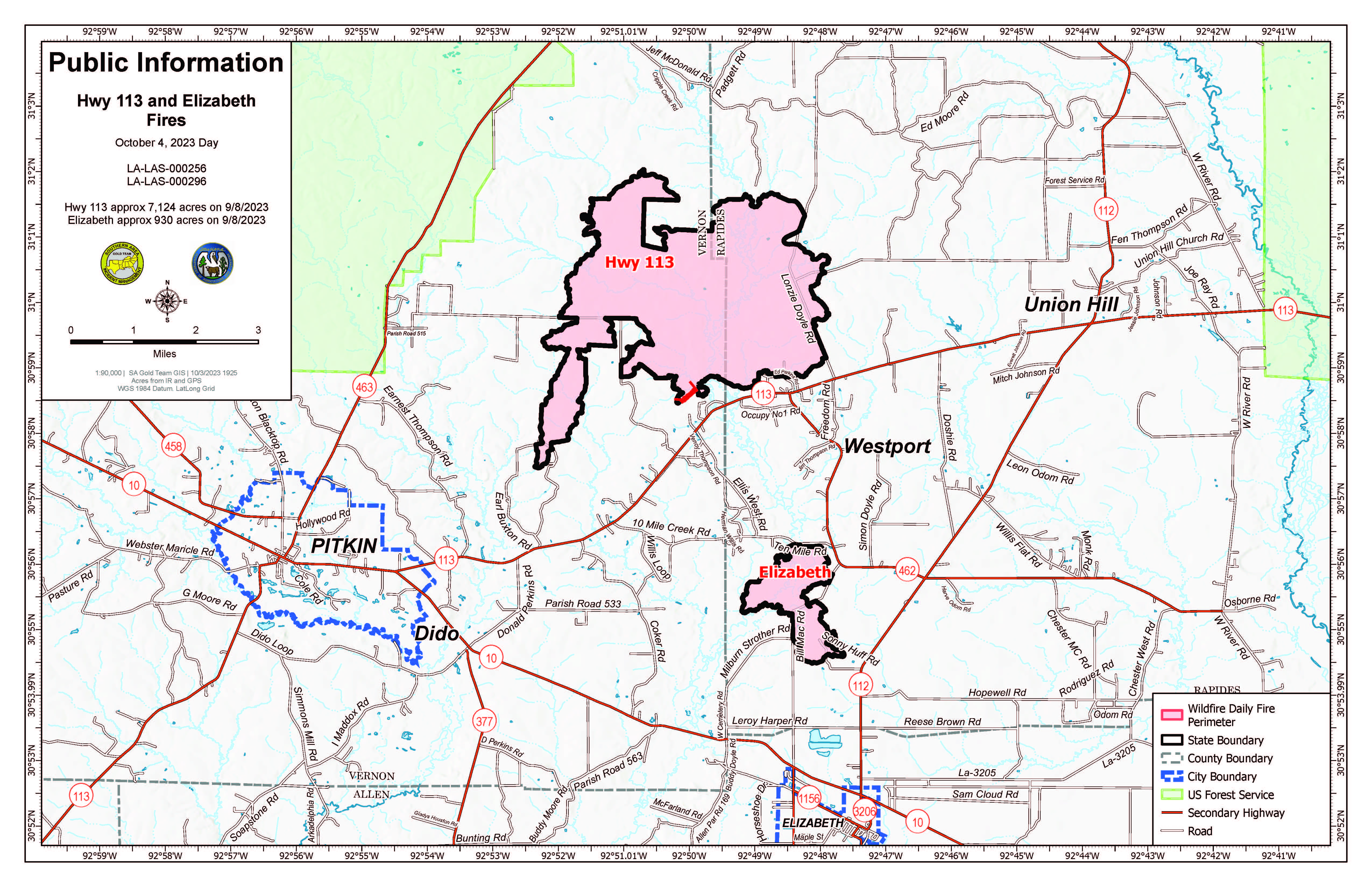
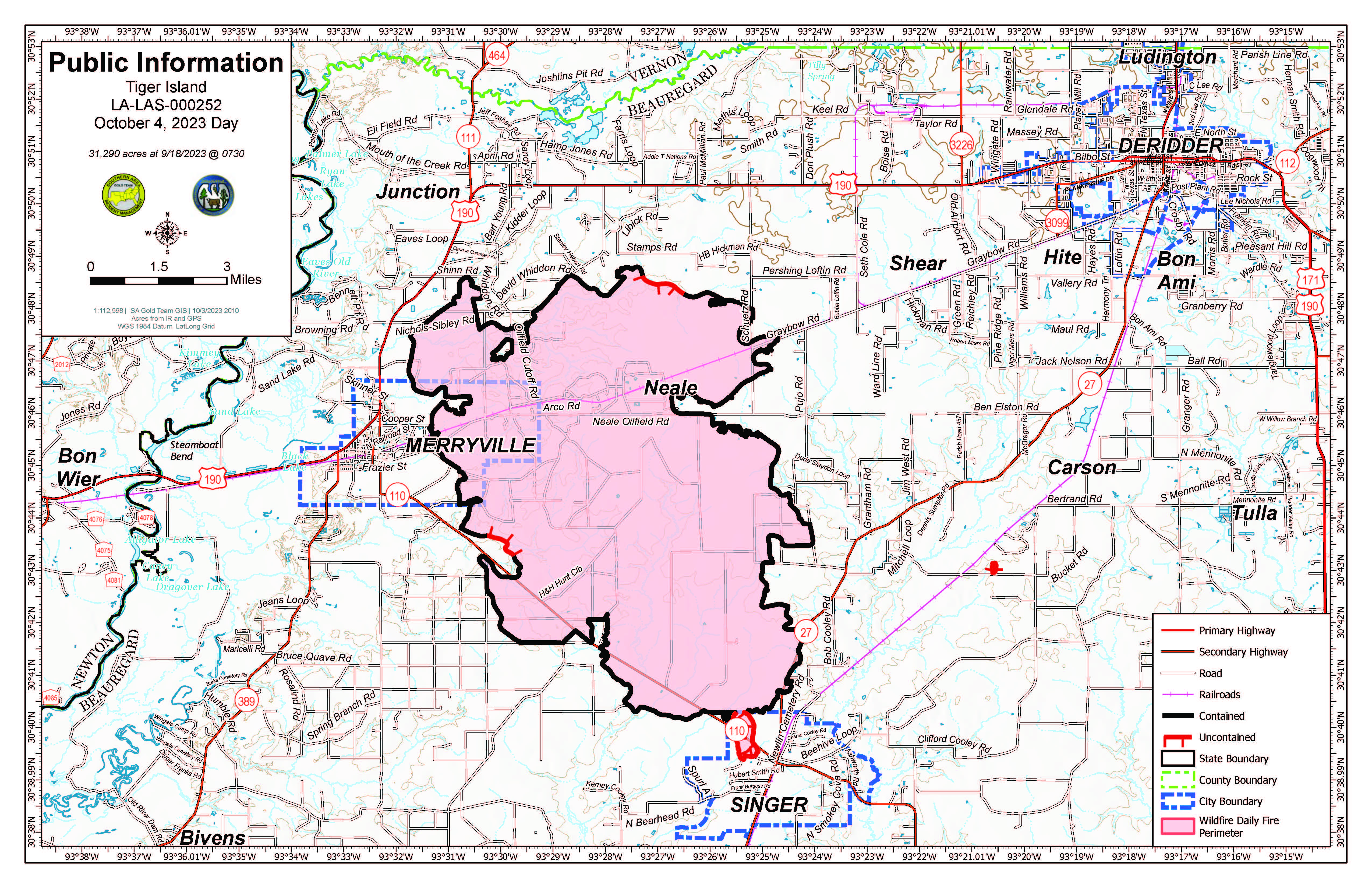
Tiger Island Fire: 31,290 acres, no change | 86% contained| 159 personnel assigned
InciWeb: https://inciweb.nwcg.gov/incident-information/lalas-tiger-island-fire
Hwy. 113 Fire: 7,124 acres, no change | 95% contained | 14 personnel assigned
InciWeb: https://inciweb.nwcg.gov/incident-information/lalas-hwy-113-fire
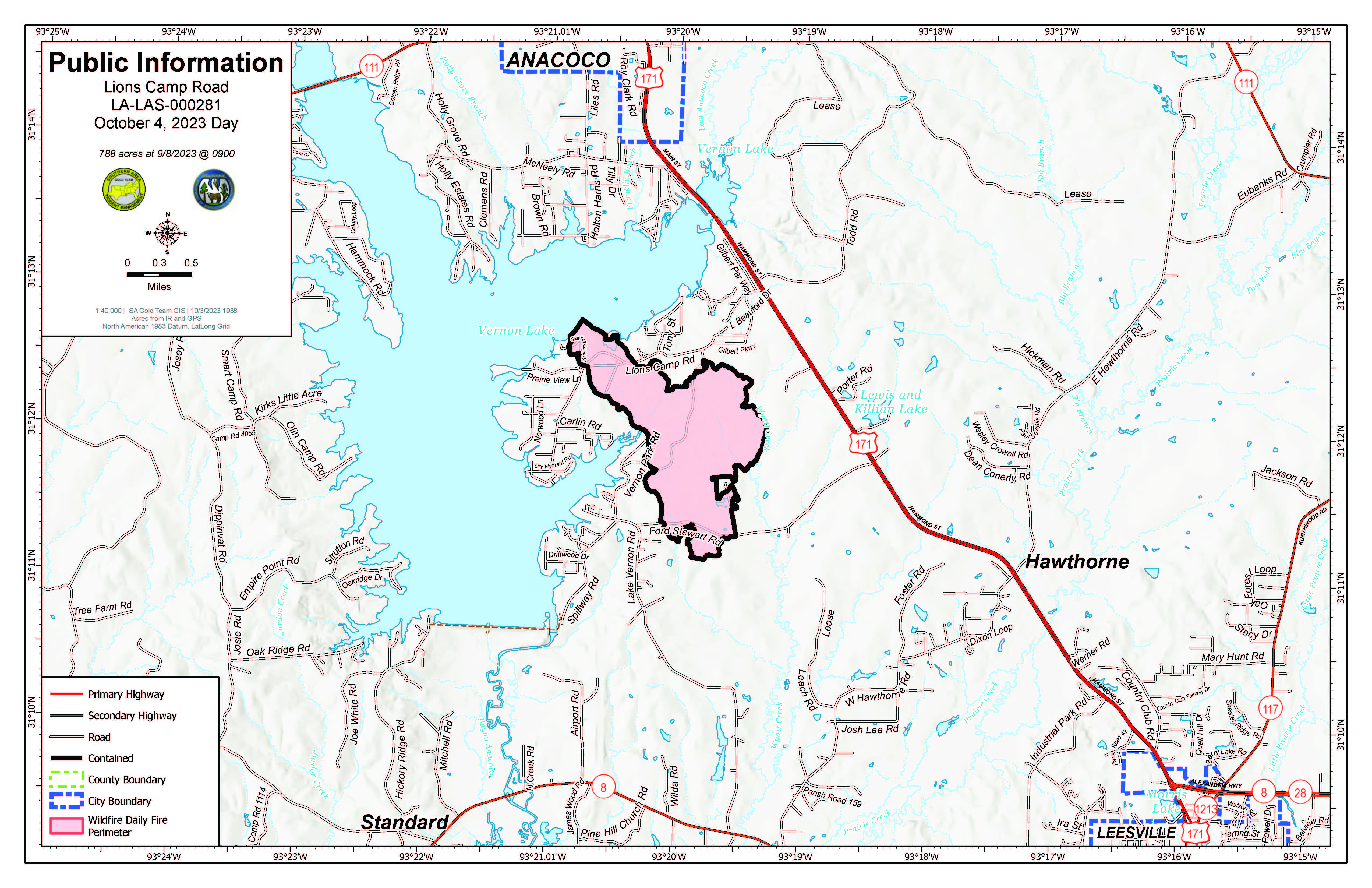
Lions Camp Road Fire: 785 acres, no change | 95% contained | 4 personnel assigned.
InciWeb: https://inciweb.nwcg.gov/incident-information/lalas-lions-camp-road-fire
Elizabeth Fire: 940 acres, no change | 98% contained | 15 personnel assigned
InciWeb: https://inciweb.nwcg.gov/incident-information/lalas-elizabeth-fire
Equipment
Type 6 engines, dozers, tractor plow units, water tenders, medical squads and ambulances and aerial resources including helicopters and fixed-wing aircraft are assigned to the fires. Parish authorities and departments, sheriff’s offices, and the Governor’s Office of Homeland Security and Emergency Preparedness are also providing additional support.
Weather and Fire Behavior
Fire danger will dip slightly today as humidity levels rise and clouds move into the area. Thursday will bring scattered showers, isolated thunderstorms and winds out of the north. Rainfall amounts are not expected to be high, and any fire danger relief will be short lived. Due to the increased cloud cover, temperatures will moderate, and afternoon humidity will trend upward. Continuing fire weather updates are available at https://www.weather.gov/lch/.
Air Quality
Air quality information is available at https://fire.airnow.gov.
Temporary Flight Restrictions (TFRs)
TFRs remain in place over the Tiger Island Fire (https://tfr.faa.gov/save_pages/detail_3_3911.html). A smaller, new TFR is in place for the Hwy. 113 and Elizabeth Fires https://tfr.faa.gov/save_pages/detail_3_4065.html).
Louisiana Statewide Burn Ban Modified
On September 27, 2023, LDAF modified its burn ban order to allow agricultural burning to resume, including but not limited to prescribed burning except for standing sugarcane. The Louisiana Office of the State Fire Marshal also modified its burn barn order to allow individual parishes to opt out of the statewide burn ban, fire chiefs to resume granting burn permissions, and certain live fire training to resume with its written permission as of September 29, 2023. This order is reevaluated weekly. As parishes opt out of the statewide burn ban, the Louisiana Burn Ban Map will be updated at https://t.ly/CETXf. Visit https://t.ly/Y5b9N for more information.
Anvil and Flat Fires Update October 4 2023
Related Incident: Anvil FireFlat Fire
Publication Type: News
Highlight:
Rogue River-Siskiyou National Forest issued an update to the Emergency Area and Road Closure for the Flat Fire, reducing the closure area and reopening roads adjacent to the fire area. Closure map and details are available here: https://bit.ly/RRSNFAlert
Anvil Fire
Size: 22,173 acres Start Date: August 25, 2023 Location: 8 miles east of Port Orford, OR
Containment: 54% Total personnel: 1,097 Resources: 29 crews, 7 helicopters, 30 engines
Yesterday's precipitation limited safe access for firefighters around the fire but will give them an advantage today. Weather permitting, crews will be shuttled in via helicopter to the west perimeter to finish two sections of handline. Crews continue to remove suppression equipment for backhaul along Elk River Road. Chipping operations and suppression repair continue along Grassy Knob Road. On the northeast edge of the fire, heavy equipment is working to reduce fuels and improve fireline. Progress on the contingency line near the southeast perimeter of the fire, towards Milbury Mountain, has been slowed due to rain but will pick up over the next few days.
The increase in wind today will give firefighters an opportunity to more easily identify isolated pockets of interior heat as those areas produce more smoke. Conditions permitting, an infrared flight will look for any significant areas of heat.
Evacuations: Curry County Sheriff’s Office has identified evacuation zones near the Anvil Fire: Zones 1, 2, and 4 are in Level 2 “Set” status. Zone 3 is in Level 1 “Ready” status. Conditions may change quickly. Monitor for updates in evacuation levels. View the interactive evacuation map at https://bit.ly/AnvilEvacs. Sign up for Curry Co. emergency alerts at https://bit.ly/CurryCoEM.
Flat Fire
Size: 34,242 acres Start Date: July 15, 2023 Location: 2 miles southeast of Agness, OR Containment: 93% Total personnel: 51 Resources: 1 crew, 3 engines
Crews are working to fall hazard trees and repair roadways to make them safe for the public. Excavators are working to repair suppression lines on the 93 working towards the river.
Emergency Fire Area and Road Closures Still in Effect: Forest closures remain in place in both fire areas. The closure area for the Flat Fire has been reduced. For current closure information and maps, please visit: https://bit.ly/RRSNFAlerts.
Fire Restrictions: The Rogue River-Siskiyou National Forest lifted all Public Use Restrictions on Forest Service lands and moved to “moderate” fire danger. The Industrial Fire Precaution Level was reduced to Level 1.
Weather: Light rain fell over much of the fire yesterday. Temperatures will warm and winds will increase today, especially on ridgetops.
Smoke: Smoke may be visible at times. For current smoke and air quality updates visit, https://bit.ly/SWORsmoke . Please drive slowly and with headlights on through any fire area.
Roads: Visit www.tripcheck.com or call 511 for current road closures. Do not use forest roads for alternate routes.
Contact Fire Information: (541) 216-4579 or (541) 237-6369
Email: 2023.anvil@firenet.gov
Facebook: facebook.com/flatfireoregon2023
X/Twitter: twitter.com/RRSNF
Inciweb Anvil Fire: bit.ly/AnvilFireOR
Inciweb Flat Fire: bit.ly/FlatFireOR
October 4 2023 Pile Burn Update
Related Incident: Lolo National Forest Prescribed Fire Operations
Publication Type: Announcement
Yesterday was a successful day of prescribed fire operations (pile burning) across many of our districts, work will continue today and throughout the rest of this week, pending conditions.
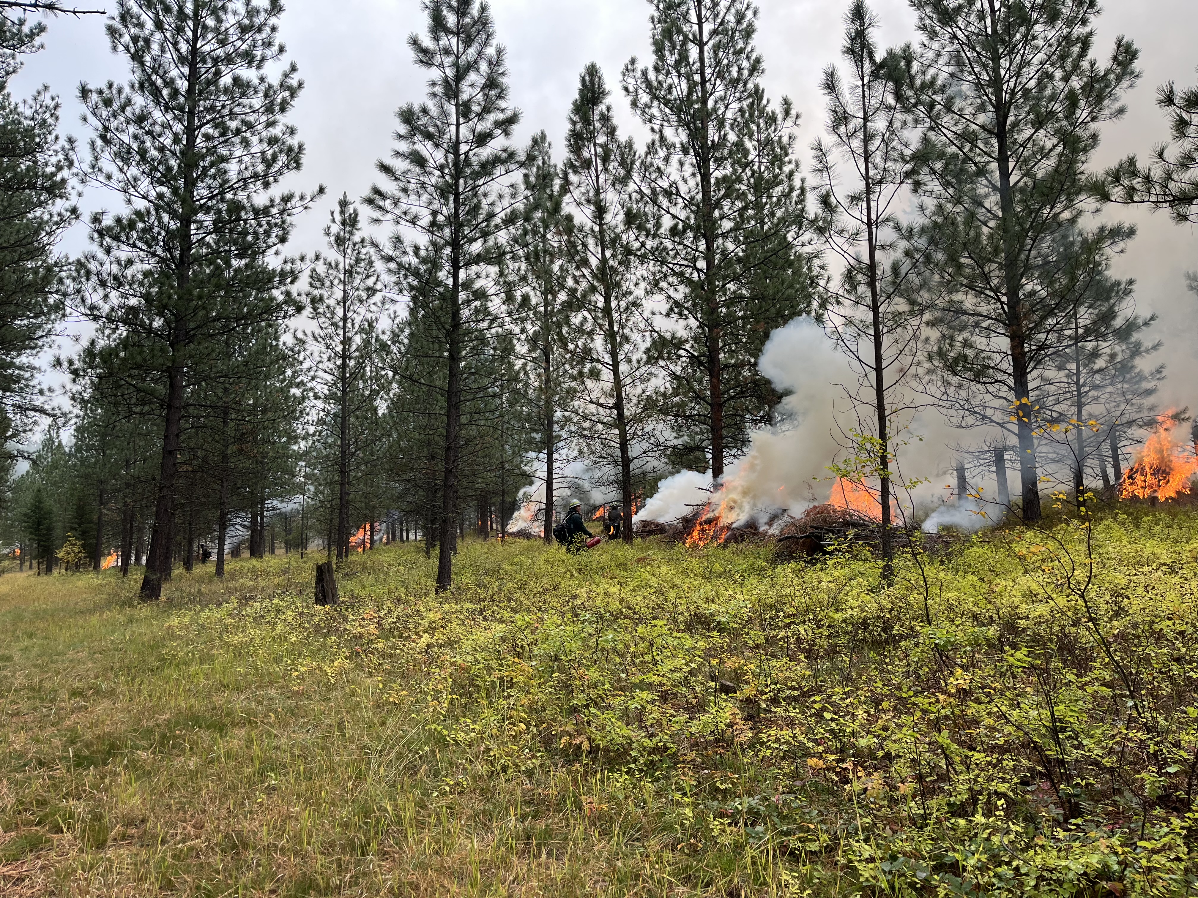
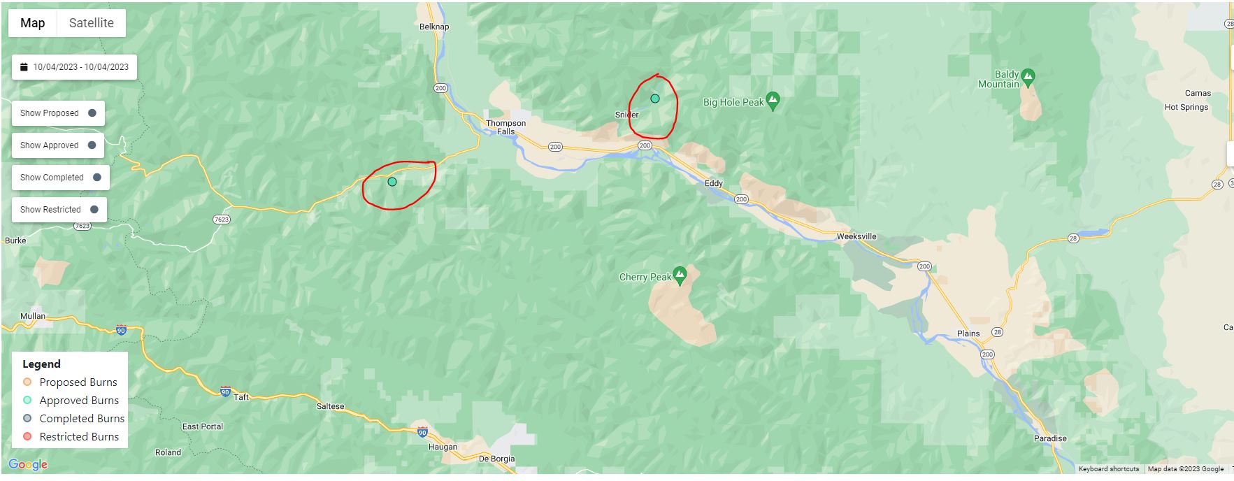
Plains/Thompson Falls Ranger District: Firefighters will be burning several piles adjacent to the community of Snider, 4 miles east of Thompson Falls, and in Prospect Creek 13 miles west of Thompson Falls. The piles in the Snider area were made from slash debris left over from mechanical thinning or hand thinning operations on the Thorne Creek Fire. These piles of woody debris have been cut and piled by fire crews, and when conditions allow, they are burned. Prescribed fire serves as a critical fire management tool to help improve forest health and mitigate the risk of wildfires. Smoke may be visible from the community of Snider and Thompson Falls.
Superior Ranger District: Firefighters will conduct up to 10 acres of hand pile burning located 7 miles southwest of St. Regis, MT in Cold Creek. Residents in the Cold Creek and Dry Creek areas may see residual smoke overnight.

Olympic National Park Fire Update October 2
Related Incident: 2023 Olympic National Park Lightning Fires
Publication Type: News
Port Angeles, Wash. – Fire activity diminished this weekend due to precipitation and cool temperatures. Smoke production was observed in down and standing deadwood.
A gradual drying trend is expected to return by the end of this week. Though fire may persist in sheltered areas, the probability of spread is minimal.
Fire Name
Initial Report
Estimated Size
Location
Hurricane
8/28/23
4 acres
2,000 ft below Hurricane Ridge parking area
Eagle Point
8/28/23
123 acres
~5 miles out Obstruction Point Road
Diamond Mountain
9/1/23
30 acres
3.3 miles NE of
Anderson Pass
Low Divide
9/1/23
340 acres
N. Fork Quinault drainage
Delabarre
9/1/23
4,165 acres
3 miles SE of Mount Christie
Martins Lake
9/2/23
122 acres
2 miles NE of Mount Christie
Mount Queets
9/14/23
7 acres
Summit of Mount Queets
Fires in the wilderness are a natural part of the ecosystems on the Olympic Peninsula; these plants and animals have evolved with fire for thousands of years. Fire can increase favorable habitat for the wildlife. When appropriate, allowing this natural process to continue lowers the risk of catastrophic fires in the future. Naturally occurring fires thin forests, open the canopy, and reduce competition for resources for plant and tree growth. Fire returns nutrients to the soil while reducing the amount of dead, woody debris. It only takes a short time after a fire for the forest to regenerate.
Background Information
All seven active fires in Olympic National Park ignited when a series of lightning strikes occurred on the Olympic Peninsula in the afternoon on August 28.
Closures
Due to wildfire activity the following closures are in effect until further notice:
- Elwha River Trail from Dodger Point Trail junction to Low Divide
- Hayden Pass Trail
- Dosewallips River Trail from Dose Meadows to Hayden Pass
- North Fork Quinault Trail from Elip Creek trail junction to Low Divide
- Skyline Trail from Elip Creek Trail junction to Low Divide
- Martin Park Trail
- Obstruction Point Road and Trailhead
Olympic National Park Wilderness Information Center (WIC) will be notifying backcountry permit holders who may be impacted by these closures. Any permit holders who plan to backpack in the above impacted areas should contact the WIC at 360-565-2992 or by emailing OLYM_WIC@nps.gov.
Weather and Fire Behavior
Forecasters expect rain to fall on the fire area through Wednesday. Cool, damp conditions and decreasing solar heating due to decreasing daylight are expected to continue to hamper fire growth.
Information for the 2023 Olympic National Park Lightning Fires can be found at: https://inciweb.wildfire.gov/incident-information/waolp-2023-olympic-national-park-lightning-fires
Olympic National Park information: www.nps.gov/olym
Olympic National Forest information: www.fs.usda.gov/olympic
State and county area burn bans: https://ecology.wa.gov/Air-Climate/Air-quality/Smoke-fire/Burn-bans
Transition from Nevada Incident Management Team 2
Related Incident: South Fork Complex
Publication Type: News
Nevada Incident Management Team 2 will be passing the command of the South Fork Complex to the Type 4 Six Rivers National Forest Team at 7:00 a.m. on October 4, 2023
Smith River Complex South Daily Update October 3 2023
Related Incident: Smith River Complex
Publication Type: News
CURRENT SITUATION: Due to hard work from firefighters and more accurate reporting, containment has increased to 90% and the total acres burned rose by 87 for a total of 94,693. Cooler temperatures and light rain yesterday and overnight helped firefighters increase the containment. The weather will be getting warmer and drier through Saturday and firefighters remain vigilant as winds will increase. Yesterday, a firefighting UAV (unmanned aerial vehicle) with infrared capabilities flew the fire and picked up some hot spots. Heat signature information was relayed to firefighting crews and they extinguished those hot spots and interior smokes. The eastern edge of the Hurdy Gurdy Fire is now completely contained. Crews will continue to assess the fire from the ground and air as the fire areas dry out and accessibility improves. There has been no reported firefighter injuries or illnesses for many days.
Extensive suppression repair and hazard abatement continues on the fire. Water bars are being constructed near primary containment lines to prepare for the rainy season. Machine work and hazard tree removal is occurring along the 17N49 road as well as south of US199 near Little Jones Rd (17N08). Major chipping operations continue in this area. Yesterday, crews made great progress with suppression repair work in Gasquet (17N69), Steven’s and Smith River areas. As the soil continues to dry out and containment increases, crews will identify additional target areas to complete suppression repair work. Positive attitudes, hard work and diligent focus by firefighters continues on day 52 of this fire.
WEATHER: Drier, breezing and warmer weather will be occurring through Saturday with rain expected at the beginning of next week. Temperatures will warm throughout the week. Northeasterly winds will increase with gusts of 30-35 mph. Firefighters will feel the continued warming and drying conditions as a result of offshore flow for the next four to five days. There is increasing chances of widespread precipitation early Monday morning and into next week.
CLOSURES: While county roads remain open, Six Rivers National Forest lands, roads, and trails around the Smith River Complex fires are closed (Forest Order No. 10-23-09). View the Order and closure map on the Forest’s website: tinyurl.com/4atens8c.
US 199 in Del Norte County is fully closed twice daily, Monday through Friday, from 8 AM to 11 AM and from 1 PM to 4 PM. During all open hours, traffic will be one-way and piloted between Grassy Flat Campground east of Gasquet and Oregon Mountain Road. Motorists should anticipate delays during all open hours. Caltrans provides information on current highway conditions online (roads.dot.ca.gov), by phone (800-427-7623), and on Facebook (facebook.com/CaltransD1).
REDUCED Closure Closure Order for Flat Fire October 3 2023 Order No 0610262366
Related Incident: Flat Fire
Publication Type: Closures
The Rogue River-SIskiyou National Forest has issued a Reduced Emergency Area and Road Closure for the Flat Fire. The full order and map is available below as an attachment.
Rogue River-Siskiyou National Forest Acting Forest Supervisor Jake Winn signed an update to the Emergency Area and Road Closure for the Flat Fire, reducing the closure area and reopening roads adjacent to the fire area. The new order is effective October 3, 2023 through December 31, 2023 unless rescinded sooner.
Please respect closure boundaries for firefighter and public safety.
ORDER NO. 06-10-26-23-66
EMERGENCY FIRE ROAD, TRAIL AND RIVER CLOSURE – Flat Fire
Pursuant to 16 USC § 551 and 36 CFR § 261.50(a) and (b), the following acts are prohibited upon general forest areas within the Rogue River-Siskiyou National Forest as described below and shown in Exhibit A. This order rescinds order number 06-10-26-23-59. This Order will be effective beginning October , 2023, through December 31, 2023, unless rescinded sooner.
PROHIBITIONS:
1. Entering into or being upon an area closed for the protection of public health and safety. 36 CFR § 261.53(e).
2. Being on a National Forest System Road. 36 CFR § 261.54(e).
3. Being on a National Forest System Trail. 36 CFR § 261.55(a)
Closure Area boundary, as shown on attached Exhibit A, is described as the entirety of the Flat Fire area starting east of the junction of FSR 3318 and NF 3680 in section T.37 S. and R. 13 W. following northeast along FSR 3318 (Wildhorse Lookout Road) to northeast section R.35S and R.11 W. and then southeast towards Indigo Creek turning southwest towards FSR 3680 and FSR 1376 and then northwest to the starting point. All roads and trails within the boundary area are closed.
EXEMPTIONS:
Pursuant to 36 CFR § 261.50 (e), the following persons are exempt from this Order:
1. Persons with Forest Service Permit No. FS-7700-48 (Permit for Use of Roads, Trails, or Areas Restricted by Regulation or Order), specifically exempting them from this Order.
2. Any Federal, State, or local officer, or member of an organized rescue or firefighting force in the performance of an official duty.
This prohibition is in addition to the general prohibitions in 36 C.F.R. Part 261, Subpart A.
Violations of this prohibition is punishable by a fine of not more than $5,000 for an individual or $10,000 for an organization, or imprisonment for not more than 6 months, or both (16 USC § 551; 18 USC §§ 3551, 3559, 3571, and 3581).
Executed in Medford, Oregon, this 3rd day of October 2023.
Signed by Jacob Winn, Acting Forest Supervisor, Rogue River-Siskiyou National Forest
Morning Update Tuesday October 3 2023
Related Incident: Bedrock FirePetes Lake FireLookout Fire2023 Horse Creek Fire
Publication Type: News
Lookout, Bedrock, Petes Lake, Horse Creek and Pothole Fires
Tuesday, October 3, 2023 - Morning Update – 9:00 a.m.
Lookout Fire - Size: 25,751 acres | Start Date: August 5 | Cause: Lightning | Containment: 50%
Bedrock Fire - Size: 31,590 acres | Start Date: July 22 l Cause: Under Investigation l Containment: 98%
Petes Lake Fire - Size: 3,254 acres | Start Date: August 25 | Cause: Lightning | Completion: 80%
Horse Creek Fire - Size: 763 acres | Start Date: August 24 | Cause: Lightning | Containment: 100%
Pothole Fire - Size: 109 acres | Start Date: August 25 | Cause: Lightning | Containment: 100%
Total Assigned Personnel: 377 | 10 engines | 6 crews | 2 dozers | 3 water tenders | 1 masticators | 2 helicopters
(Walterville, Ore.) – Crews continue to make progress toward completing incident objectives on the fires. On some fires, success is measured by percentage of containment and on others, it is defined by completing objectives that have a high probability of protecting lives and property without causing undue risk to personnel. Incident managers are continuously evaluating and refining strategies while working toward completing incident objectives of ensuring the protection of communities, infrastructure, resources and most importantly, public and firefighter lives.
Containment on the Lookout Fire remains at 50 percent. Containment is achieved when control lines are in place and fuels have been removed, either by burning or physical removal, between the control lines and the fire’s edge. On the northern edge of the Lookout Fire, dense stands of danger trees posed unacceptable risks to firefighter safety. As an alternative to building containment lines here, personnel improved existing roadways elsewhere in safer terrain to create a continuous fuel break that would halt fire were it to spread north. The onset of autumn weather abated fire growth before reaching these lines. Therefore, they are not categorized as containment lines, because they are not directly on the fire’s edge. Similar tactics have been employed on the Petes Lake Fire.
Crews are engaged in crucial repair work around the fire, with a focus on minimizing soil erosion and supporting ecosystem recovery. Activities include removal of woody debris and suppression-generated materials, drainage and culvert clearing and constructed fire line naturalization, all of which contribute to rehabilitation of the affected areas. Yesterday, fire personnel discovered a significant amount of structure protection equipment left behind and wet weather is delaying some work. Fire managers will pause large-scale demobilization of resources while the impact of these factors is assessed.
Burned Area Emergency Rehabilitation (BAER): Soil scientists from the Lookout BAER Team have finalized the soil burn severity map. Specialists assigned to the incident have been using draft versions of this map to take into the burned areas and ground truth initial findings. Field work is finishing up today in the highest burn severity areas to note the potential for debris flows and confirm any elevated potential for human health and safety risks in and near developed recreation areas and critical infrastructure.
Weather: Light rain will linger over the fire area this morning. As a high-pressure front moves into the area later today, a period of warming and drying will persist late into the week.
Forest Closures: Established closures on the Willamette National Forest remain in place around fire-impacted areas, including the Lookout and Bedrock Fires. The public is urged to “Know Before You Go” by visiting the Willamette National Forest official webpage. For specific hunting-related questions, contact Oregon Department of Fish and Wildlife at (503) 947-6000.
Safety: Some fire-impacted areas remain closed as critical suppression repair work continues. The public is asked to exercise caution along roadways around the fire. Drivers should be extra vigilant along Forest Road 15 between Highway 126 and Highway 20, where crews and heavy equipment are traveling and engaging in suppression repair work.
Quarry Fire Daily Update Oct 3
Related Incident: 2023-STF-Quarry Fire
Publication Type: Announcement
Quarry Fire Update
Monday, October 2nd, 2023
Stanislaus National Forest
Incident Management Team (Type-3)
PIO Contacts: Eugenie Moore - eugenie.moore@usda.gov
steve lyon - slyon@nps.gov
Fire Statistics:
Location: The Quarry Fire is located on the Stanislaus National Forest, Mi-Wok Ranger District, off Forest Road 3N01, east of Bourland Creek and near the Emigrant Wilderness west of Cherry Creek.
Acres Burned to Date: 5,557
Cause: Lightning
Containment: 13.5%
Total Personnel: 118
Injuries: 0
Background: The Quarry fire was one of many fires ignited by lightning strikes across the forest on September 9, 2023. District fire managers immediately worked to ensure these naturally ignited fires stayed within pre-determined boundaries. Fire personnel with the Stanislaus National Forest are currently managing the Quarry Fire to achieve multiple resource objectives.
Current Activities: Current Activities: No fire movement today due to recent moisture. Heavier fuels continue to burn down and smolder, with moderate smoke production, and smoke is visible in the fire area. Crews are making improvements to holding lines, anticipating more fire spread to the north as weather conditions dry out through the week. Crews are using natural features such as granite and recently burned areas for containment lines and working closely with resource specialists to minimize impacts to biological habitats.
Fire professionals are managing fire behavior and intensity to provide for multiple resource benefits including reducing concentrations of all fuels, re-establishing multigenerational timber stands, improving wildlife habitat, promoting plant diversity, and re-introducing fire into fire adapted ecosystems.
Closures: Soft closures are in effect to provide for the safety of the public utilizing public lands as well as fire personnel working in the area. The soft closures are an encouragement for the public to stay clear of the area, to find alternate routes to their locations and to provide fire personnel the widest berth possible as they go about their mission.
With the public’s cooperation, we will continue to monitor the number and duration of each, recognizing that fire personnel and public safety is the focus.
As of October 2, 2023, the following soft closures are in effect:
2N71 where it meets 3N16
3N21 where it meets 3N16
3N21 where it meets 3N01
3N22 where it meets 3N01
3N34Y
3N01H
3N01J
3N01L
3N16
3N16 at 3N94
Smoke: Smoke impacts from the Quarry Fire, the prescribed burns of the Experimental Forest, Dry Meadows and Beardsley Burn units on the Summit Ranger District will cause smoke to settle in low lying areas. Check out the fire and smoke map at fire.airnow.gov for more information.
More Information:
INCIWEB - Quarry Fire Info - https://inciweb.wildfire.gov/incident-information/castf-2023stfquarry-fire
Stanislaus National Forest – Official Website - https://www.fs.usda.gov/stanislaus