
Informacin actual para los incendios Anvil y Flat 9 de octubre 2023
Related Incident: Anvil FireFlat Fire
Publication Type: News
Incendio Anvil
Área: 22,170 acres Fecha de inicio: 25 de agosto, 2023 Localizado: 8 millas Este de Port Orford, OR
Contenido: 60% Personal: 636 Recursos: 14 escuadrillas de bomberos, 2 helicópteros, 14 camiones de bomberos
Las escuadrillas de bomberos trabajando sobre el lado Este del incendio han completado la extracción del equipo y continuaron monitoreando el área que todavía presenta fuentes de calor. Las maquinas excavadoras se encuentran completando la reparación de supresión en las líneas construidas por buldóceres. Asimismo, se finalizó el trabajo de astillado a lo largo de la carretera 81 en el perímetro Noroeste. En las líneas de buldóceres localizadas en la zona Norte se continua con los trabajos arduos de reparación de supresión. Vuelos infrarrojos en dicha área, mostraron un calentamiento mínimo proveniente del interior de las líneas de contención. Está por concluirse con el trabajo de reparación de supresión cerca de Elk River Road. Dependiendo de las condiciones climáticas, la labor de astillamiento podría completarse el día de hoy. En el perímetro Sur, la maquinaria masticadora termino su trabajo y las operaciones de astillado están por ser concluidas al final de la carretera 5502.
El Grupo 12 Northwest arribo el día de ayer y continuara el trabajo realizado por el Grupo 1 del Área Sureste (Southwest Area Team 1). El día de mañana, se realizará la transferencia de comandos.
Evacuaciones: El Nivel de Evacuación 2 en las zonas alrededor del Incendio Anvil, ha sido reducido a Nivel 1. No hay estados de Evacuación para el Incendio Flat. Puede ver un mapa interactivo de Evacuación en:
https://bit.ly/AnvilEvacs. Inscríbase en Alertas de Emergencia para el Condado de Curry en: https://bit.ly/CurryCoEM.
Incendio Flat
Área: 34,242 acres Inicio:15 de agosto, 2023 Localizado: 2 millas Sureste de Agness, OR
Contención: 93% Personal: 54 Recursos: 3 camiones de bomberos, 1 escuadrilla de bomberos.
El día de ayer, los bomberos con la maquinaria excavadora finalizaron la reparación de supresión sobre la mitad del área Norte del incendio. Se continúa asegurando las áreas en las afueras de la carretera alrededor de Game Lake.
Las áreas para Emergencia de Incendio y las Ordenes de Cierre de Carreteras aún se encuentran en efecto:
Permanecen en pie la Orden de Cierre en el Bosque para ambos incendios. Se dio un cambio en la Orden de Emergencia de cierre de Área y carreteras para el incendio Flat, reduciendo el tamaño del área afectada por dicha orden y adyacente al área del incendio. La orden se dio en efecto el 3 de octubre, 2023 y rescinde el 31 de diciembre, 2023, a menos que sea anulada antes de esa fecha. Puede encontrar mapas e información más detallada en: https://bit.ly/RRSNFAlerts o https://inciweb.wildfire.gov/incident-closures/orrsf-anvil-fire
Restricciones: El Bosque Nacional de Rogue River Siskiyou, levanto todas las Restricciones en las tierras del bosque para uso del público y movió a un nivel de peligro de incendio “Bajo”. El Nivel de Precaución de Incendios se encuentra a un Nivel 1.
Condiciones climáticas: Se espera la presencia de lluvias y viento para los próximos días lo cual podría limitar el trabajo del equipo pesado en las áreas del incendio.
Condiciones del humo: Para información actualizada en cuanto a la presencia del humo y la calidad del aire, visite: https://bit.ly/SWORsmoke. Por favor conduzca despacio y con las luces encendidas a través de cualquier área de incendio
Líneas Informativas: (541) 216-4579
Email: 2023.anvil@firenet.gov
Facebook: facebook.com/flatfireoregon2023
X/Twitter: twitter.com/RRSNF
Inciweb Anvil Fire: bit.ly/AnvilFireOR
Inciweb Flat Fire: bit.ly/FlatFireOR
Anvil and Flat Fires Update October 9 2023
Related Incident: Anvil FireFlat Fire
Publication Type: News
Anvil Fire
Size: 22,170 acres Start Date: August 25, 2023 Location: 8 miles east of Port Orford, OR
Containment: 60% Total personnel: 636 Resources: 14 crews, 2 helicopters, 14 engines
Crews on the east side of the fire completed backhaul of equipment and continued to monitor for any remaining areas of heat. Excavators in the area are completing suppression repair on dozer lines. Chipping along the 81 Road on the northwest perimeter of the fire is complete. Suppression repair is ongoing on the northern dozer lines. An infrared flight in this area showed minimal heat that was well interior of the containment line. Suppression repair near Elk River Road is nearly complete. Chipping in this area should be completed today, weather permitting. On the south perimeter mastication is complete and chipping operations are almost to the end of the 5502 Road.
Northwest Team 12 arrived yesterday and will shadow Southwest Area Team 1 today. Transfer of command will occur tomorrow morning.
Evacuations All level 2 evacuation zones around the Anvil Fire have been reduced to Level I. There are no evacuation statuses on the Flat Fire. View the interactive evacuation map at https://bit.ly/AnvilEvacs. Sign up for Curry Co. emergency alerts at https://bit.ly/CurryCoEM.
Flat Fire
Size: 34,242 acres Start Date: July 15, 2023 Location: 2 miles southeast of Agness, OR
Containment: 93% Total personnel: 54 Resources: 1 crew, 3 engines
Excavators finished suppression repair on the northern half of the fire yesterday. Engines working around the Game Lake continue to secure areas off the road.
Emergency Fire Area and Road Closures Still in Effect:
Forest closures remain in place in both fire areas. There is an update to the Emergency Area and Road Closure for the Flat Fire, reducing the closure area and reopening roads adjacent to the fire area. The new order is effective October 3, 2023 through December 31, 2023 unless rescinded sooner. For current closure
information and maps, please visit: https://bit.ly/RRSNFAlerts or https://inciweb.wildfire.gov/incident-closures/orrsf-anvil-fire.
Restrictions: The Rogue River-Siskiyou National Forest lifted all Public Use Restrictions on Forest Service
lands and moved to "low" fire danger. The Industrial Fire Precaution Level was reduced to Level 1.
Weather: Rain and wind is expected over the next few days and may limit work by heavy equipment in the fire areas.
Smoke: For current smoke and air quality updates visit, https://bit.ly/SWORsmoke. Please drive slowly and
with headlights on through any fire area.
Contact Fire Information: (541) 216-4579
Email: 2023.anvil@firenet.gov
Facebook: facebook.com/flatfireoregon2023
X/Twitter: twitter.com/RRSNF
Inciweb Anvil Fire: bit.ly/AnvilFireOR
Inciweb Flat Fire: bit.ly/FlatFireOR
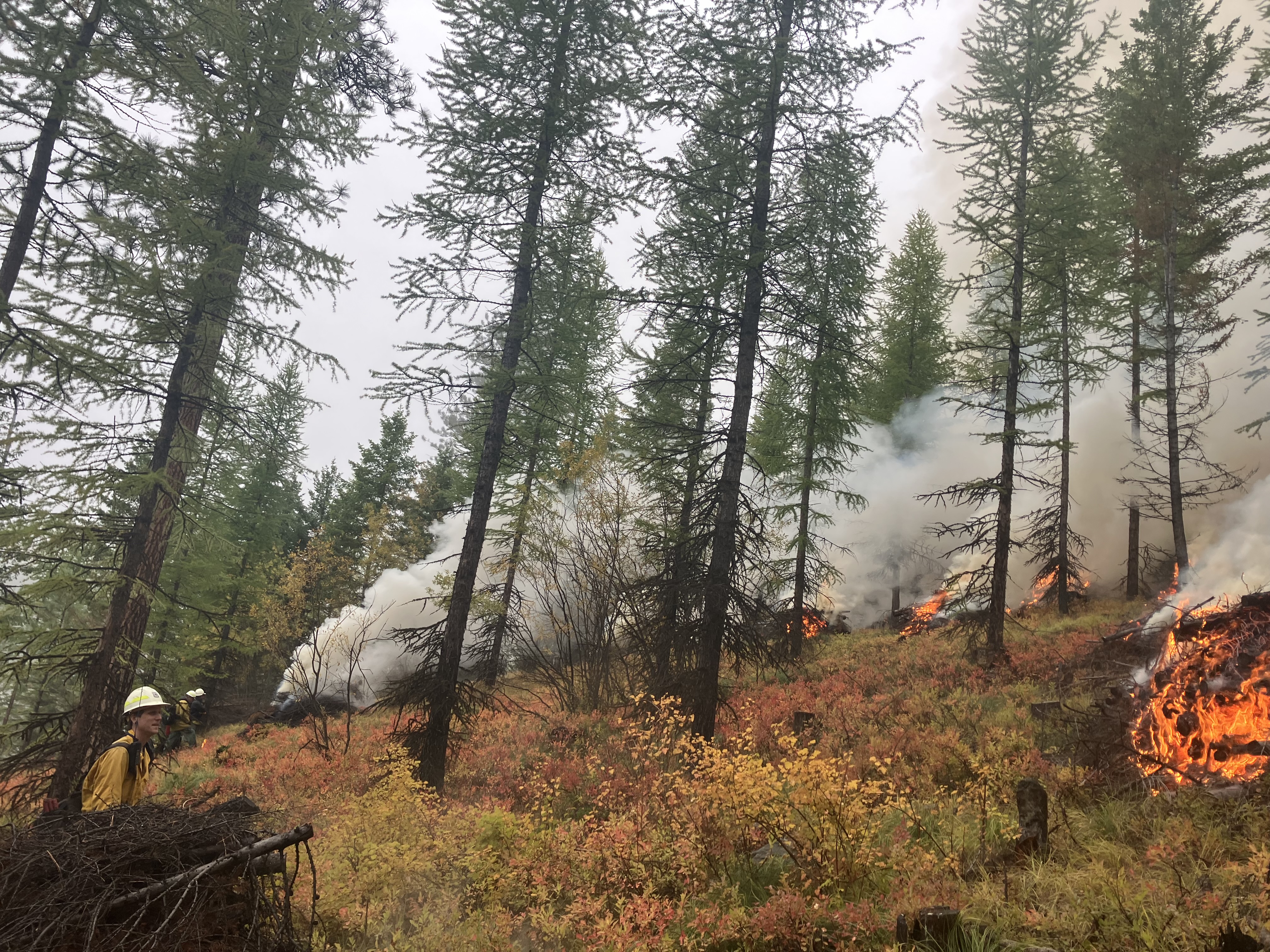
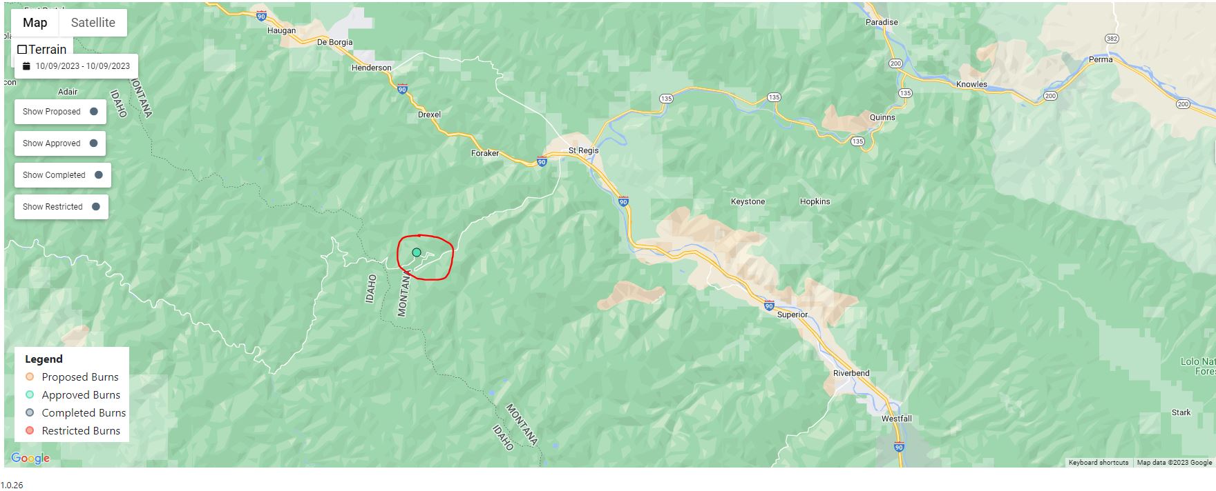
October 9 2023 Pile Burn Update
Related Incident: Lolo National Forest Prescribed Fire Operations
Publication Type: Announcement
The Superior Ranger District is planning to conduct prescribed fire operations (pile burn) in the Cold Creek drainage, 7 miles southwest of St. Regis, MT in an effort to reduce hazardous fuels. Area residents may see smoke in the area over the next few days.
Learn more about prescribed fire at: https://www.fs.usda.gov/detail/lolo/fire/?cid=fseprd1139761.

Quarry Fire Daily Update Oct 8
Related Incident: 2023-STF-Quarry Fire
Publication Type: Announcement
Quarry Fire Update
Sunday, October 8th, 2023
Stanislaus National Forest
Incident Management Team (Type-3)
PIO Contacts:
Eugenie Moore - eugenie.moore@usda.gov
steve lyon - slyon@nps.gov
Fire Statistics:
Location: The Quarry Fire is located on the Stanislaus National Forest, Mi-Wok Ranger District, off Forest Road 3N01, east of Bourland Creek and near the Emigrant Wilderness west of Cherry Creek.
Acres Burned to Date: 6,053
Cause: Lightning
Containment: 33%
Total Personnel: 58
Injuries: 0
Current Activities: Today, fire crews held off on firing to secure perimeters, clean up containment lines, and monitor the fire’s progression. Forecast weather outlook has improved over previous predictions, so today’s prep work will support firing operations this week.
Background: Fire professionals using Unmanned Aerial Systems (UAS, also known as drones) are managing fire behavior and intensity to provide for multiple resource benefits including reducing concentrations of all fuels, re-establishing multi-generational timber stands, improving wildlife habitat, promoting plant diversity, and re-introducing fire into fire adapted ecosystems.
These UAS flights have a light footprint to bring fire to sensitive areas with minimal impact on the wilderness.
Closures: Soft closures are in effect to provide for the safety of the public utilizing public lands as well as fire personnel working in the area. The soft closures are an encouragement for the public to stay clear of the area, to find alternate routes to their locations and to provide fire personnel the widest berth possible as they go about their mission.
With the public’s cooperation, we will continue to monitor the number and duration of each, recognizing that fire personnel and public safety is the focus.
As of October 8, 2023, the following soft closures are in effect:
2N71 where it meets 3N16
3N21 where it meets 3N16
3N21 where it meets 3N01
3N22 where it meets 3N01
3N17 where it meets 3N29
3N29 to 3N29C
3N16
3N34Y
3N01H
3N01J
3N01L
Smoke: Smoke impacts from the Quarry Fire, the prescribed burns of the Experimental Forest, Dry Meadows and Beardsley Burn units on the Summit Ranger District will cause smoke to settle in low lying areas. Check out the fire and smoke map at fire.airnow.gov for more information.
More Information:
INCIWEB - Quarry Fire Info - https://inciweb.wildfire.gov/incident-information/castf-2023stfquarry-fire
Stanislaus National Forest – Official Website - https://www.fs.usda.gov/stanislaus
Oct 8 Update Yuba Underburn
Related Incident: Yuba-Unit D
Publication Type: Announcement
Ignitions will begin today on Yuba D underburn with the goal of completing 165 acres. Smoke will be visible from Yuba Pass along Hwy 49 corridor south towards Sierra City. Smoke impacts will be carefully monitored and immediate action will be taken should smoke becomes an issue.
Oct 8 Update Sagehen Hills Underburn
Related Incident: Sagehen Hills Underburn
Publication Type: Announcement
128 acres of understory burning were successfully completed yesterday. There will be no ignitions today or tomorrow, Oct. 9 due to forecasted winds. Fire staff will focus on securing completed units and prepping remaining units for ingnitions later into the week.
Morning Update Sunday October 8 2023
Related Incident: Lookout FireBedrock FirePetes Lake Fire2023 Horse Creek Fire
Publication Type: News
Lookout, Bedrock, Petes Lake, Horse Creek and Pothole Fires
Sunday, October 8, 2023 - Morning Update – 9:00 a.m.
Lookout Fire - Size: 25,754 acres | Start Date: August 5 | Cause: Lightning | Containment: 60%
Bedrock Fire - Size: 31,590 acres | Start Date: July 22 l Cause: Under Investigation l Containment: 100%
Petes Lake Fire - Size: 3,254 acres | Start Date: August 25 | Cause: Lightning | Completion: 80%
Horse Creek Fire - Size: 763 acres | Start Date: August 24 | Cause: Lightning | Containment: 100%
Pothole Fire - Size: 109 acres | Start Date: August 25 | Cause: Lightning |Containment: 100%
Total Assigned Personnel: 298 | 4 engines | 5 crews | 1 dozer | 2 water tenders
(Walterville, Ore.) – Hot and dry conditions caused fuels smoldering in the fire’s interior to intensify and produce visible smoke in some areas. In addition, new areas of heat were spotted near control lines and quickly extinguished by firefighters. Suppression repair work on the eastern portion of the Lookout Fire is nearing completion. Backhauling of equipment continues across the Lookout and Bedrock fires.
Patrolling and monitoring are essential components in the later stages of a fire management plan. When fires burn in remote areas where the risk to life and property is minimal and loss is not a direct concern, personnel will monitor fire behavior and respond as needed. Fire managers are monitoring the Petes Lake Fire. Crews patrol control lines to suppress spot fires and extinguish overlooked hot spots. Resources have been patrolling the Lookout, Bedrock and Horse Creek Fires since the fires were brought under control.
Weather: It will continue to be warm and dry until Monday when temperatures decrease and humidity increases. As much as one inch of rain is expected to fall over the fire area beginning Monday and continuing into Wednesday.
Forest Closures: Established closures on the Willamette National Forest remain in place around fire-impacted areas, including the Lookout and Bedrock Fires. The public is urged to “Know Before You Go” by visiting the Willamette National Forest official webpage. For specific hunting-related questions, contact Oregon Department of Fish and Wildlife at (503) 947-6000.
Safety: Some fire-impacted areas remain closed as critical suppression repair work continues. The public is asked to exercise caution along roadways around the fire. Drivers should be extra vigilant along Forest Road 15 between Highway 126 and Highway 20, where crews and heavy equipment are traveling and engaging in suppression repair work.
2023 SRF Lightning Complex Update October 8 2023
Related Incident: 2023 SRF Lightning Complex and Redwood Lightning Complex
Publication Type: News
Fire Update
2023 SRF Lightning Complex
Sunday, October 8, 2023 – 8:00 A.M.
California Interagency Incident Management Team 16
John Goss, Incident Commander
Information Phone: 530-618-3339
Email: 2023.lightningcomplex@firenet.gov
Information Staffing Hours: 8 am to 8 pm
This update covers 6 of the 15 fires being managed as part of the SRF Lightning Complex. The Copper Fire (2184 acres) was absorbed by the Blue Creek #2 Fire. On September 22, 2023, the Bluff #1 Fire (4270 acres) and Blue Creek #2 Fire (9751 acres) were absorbed by the Mosquito Fire. The combination of Blue Creek #2 Fire, Bluff #1 Fire, and Mosquito Fire is now referred to as the Mosquito Fire. On September 30, 2023 we incorporated the management of the Hancock fire (1,728 acres, 100% contained). The remaining 6 fires (Big Foot, Blue Creek, Creek, Flat, Iron, and Merrill) totaling 34 acres, are contained and in patrol status. They are checked daily, and their size and containment remain unchanged.
Current Situation:
The 15 fires on this incident total 49,784 acres and overall containment is 75%. In total, 390 personnel are assigned to the incident. A storm system with wetting rain is expected to impact the Complex Monday. Firefighters prepare to respond to any need for service and take advantage of the window of opportunity the cooler weather will provide in fully containing the fire. This written incident update will be distributed every other day. If fire conditions necessitate this update will return to being distributed as often as necessary.
Crews continue to actively assess the conditions of the Pearch and Mosquito Fires. Prioritizing the safety of firefighters and the public is paramount, given that recent rainfall has heightened the risk of fire-weakened trees falling due to the saturation of soil. Continuous monitoring efforts have been extended to cover the remote Marlow Fire and the north side of the Mosquito Fire. The mowing and the mastication work taking place across the fire is nearing completion. On the Pearch Fire, the process of backhauling pumps and hoses from locations where they are no longer needed has been completed. Hazard tree removal, chipping, grading, road repair, and suppression repair remains a high priority.
Firefighters are closely monitoring the Highway 96 corridor and Salmon River Road for any signs of falling rocks, debris, or fire activity. Both CalTrans and Siskiyou County crews remain on standby to clear roadways if necessary. Fire activity is expected to moderate over the next few days, due to wet conditions and precipitation predicted for the fire area. Tactical patrol of the fire’s edge ensures that it remains in the existing footprint.
Pearch Fire (12,146 acres, 68% contained) – The Pearch Fire remains in Patrol status with very limited activity as mop up continues. Firefighters have completed all backhaul and suppression repair on this incident. Small pockets of smoke are being generated near the Salmon River, but they are no threat to the line.
Mosquito Fire (33,781 acres, 68% contained) –Suppression repair efforts are complete on the northeastern edge of the fire near the Dillon Mountain and Sidewinder Road. Beans Ridge repair efforts are ongoing. Increased fire activity due to warmer temperatures was observed near Dillon Mountain and Lightning Ridge yesterday, but they were well within the existing containment lines. The Slate Creek mastication and chipping project was completed. Patrol along the western edge ensures the fire stays within the existing footprint.
Marlow Fire (1,988 acres, 100% contained) – Minimal activity is reported on the Marlow Fire, which is in a remote area. The fire is contained by indirect control lines to the east and south, as well as prior fire footprints where fuels are less dense. No values or structures are currently threatened by the Marlow Fire.
Monument (2 acres, 100% contained), Let er-Buck (96 acres, 100% contained) and Hancock (1,729 acres, 100% contained) Fires – A confinement strategy has been employed for these three fires due to the limited values at risk and the challenging, remote, and steep terrain, which presents safety concerns for firefighters. Natural fire barriers such as rock outcroppings and old fire footprints with sparse fuels are being used to contain fire growth until the arrival of season-ending precipitation. Regular monitoring by air ensures that both fires remain within an acceptable perimeter, all are now considered 100% contained.
Weather: Clouds will begin to increase across the area on Sunday as moisture in the middle and upper levels of the atmosphere increase ahead of the storm system set to impact the fire beginning Monday. The primary change will be increasing clouds which will keep temperatures a few degrees cooler, and humidity values a few points higher as compared to Saturday. Overnight Sunday into Monday, a front will approach the area with a band of rain expected to begin across western portions of the fire around sunrise. Precipitation will spread eastward across the remainder of the fire and ICP. Generally, accumulations will range from one-half to one inch on Monday with locally higher amounts possible over favored aspects.
Please stay informed and exercise caution in the affected areas and be aware that rain and wet conditions may lead to ongoing weather-related challenges.
Evacuation Information
Siskiyou County Office of Emergency Services: https://www.co.siskiyou.ca.us/emergencyservices
Closures
Six Rivers National Forest: Area and campground closures are in effect on portions of Six Rivers National Forest. They can be found at: https://www.fs.usda.gov/detail/srnf/notices/?cid=FSEPRD1096395.
Additional Fire Information
Facebook: https://www.facebook.com/2023SRFRedwoodLightning
More Fire Information Links: www.linktr.ee/srffirepio
For Air Quality Information: www.airnow.gov
NOTE: For information about the Elliot Fire which is part of the
Happy Camp Complex, please visit https://linktr.ee/happycampcomplex2023 .
Anvil and Flat Fires Update October 8 2023
Related Incident: Anvil FireFlat Fire
Publication Type: News
Anvil Fire
Size: 22,170 acres Start Date: August 25, 2023 Location: 8 miles east of Port Orford, OR
Containment: 60% Total personnel: 664 Resources: 14 crews, 3 helicopters, 15 engines
A collaborative effort between Coos Forest Protective Association and fire crews assigned to the Anvil Fire resulted in an increase in containment yesterday as direct line on the west side of the fire was completed. An infrared flight over the Grassy Knob area showed no heat signatures or areas of concern. A masticator will be added to the suppression repair effort on northern lines today. Crews are close to completing chipping on the 81 Road. On the south line, mastication continues west on the 180 Road and near China Mountain today. The Burned Area Emergency Response Team will be assessing areas in Grassy Knob, the lower half of the northern finger and on the east side of the 5201 Road.
Evacuations: All level 2 evacuation zones around the Anvil Fire have been reduced to Level I. There are no evacuation statuses on the Flat Fire. View the interactive evacuation map at https://bit.ly/AnvilEvacs. Sign up for Curry Co. emergency alerts at https://bit.ly/CurryCoEM.
Flat Fire
Size: 34,242 acres Start Date: July 15, 2023 Location: 2 miles southeast of Agness, OR
Containment: 93% Total personnel: 54 Resources: 1 crew, 3 engines
Crews are finishing suppression repair on the northern perimeter of the fire. Work near Game Lake is completed.
Emergency Fire Area and Road Closures Still in Effect:
Forest closures remain in place in both fire areas. There is an update to the Emergency Area and Road Closure for the Flat Fire, reducing the closure area and reopening roads adjacent to the fire area. The new order is effective October 3, 2023 through December 31, 2023 unless rescinded sooner. For current closure information and maps, please visit: https://bit.ly/RRSNFAlerts or https://inciweb.wildfire.gov/incident-closures/orrsf-anvil-fire.
Fire Restrictions: The Rogue River-Siskiyou National Forest lifted all Public Use Restrictions on Forest Service lands and moved to “low” fire danger. The Industrial Fire Precaution Level was reduced to Level 1.
Weather: The weather will start to cool today, and rain will set in late in the evening. Rain and winds out of the southwest will continue into Monday and Tuesday. The predicted amount of precipitation will reduce visible smoke on the fire and may limit work by heavy equipment in fire areas.
Smoke: For current smoke and air quality updates visit, https://bit.ly/SWORsmoke . Please drive slowly and with headlights on through any fire area.
Roads: Visit www.tripcheck.com or call 511 for current road closures. Do not use forest roads for alternate routes.
Contact Fire Information: (541) 216-4579
Email: 2023.anvil@firenet.gov
Facebook: facebook.com/flatfireoregon2023
X/Twitter: twitter.com/RRSNF
Inciweb Anvil Fire: bit.ly/AnvilFireOR
Inciweb Flat Fire: bit.ly/FlatFireOR
Informacin actual para los incendios Anvil y Flat 8 de octubre 2023
Related Incident: Anvil FireFlat Fire
Publication Type: News
Incendio Anvil
Área: 22,170 acres Fecha de inicio: 25 de agosto, 2023 Localizado: 8 millas Este de Port Orford, OR
Contenido: 60% Personal: 664 Recursos: 14 escuadrillas de bomberos, 3 helicópteros, 15 camiones de bomberos
El día de ayer, a través de un esfuerzo conjunto entre la Asociación Para la Protección del Bosque Coos (Coos Forest Protective Association) y las escuadrillas de bomberos asignados al Incendio Anvil, se logró una mayor contención del incendio al completarse las líneas directas sobre el lado Oeste. Un vuelo infrarrojo sobre el área de Grassy Knob no mostro señales de fuentes de calor o zonas problemáticas. El día de hoy, fue asignada una masticadora adicional en los esfuerzos de reparación de supresión sobre las líneas localizadas al lado Norte. Otras escuadrillas de bomberos están a punto de concluir el astillado en la carretera 81. Sobre la línea Sur, el día de hoy se continuará utilizando la masticadora moviéndose hacia el Oeste sobre la carretera 180 cercana a China Mountain. El Grupo para Responder a Emergencia en Áreas Incendiadas, estará evaluando zonas en Grassy Knob, localizada en la mitad de la parte inferior y sobre el lado Este de la carretera 5201.
Evacuaciones: El Nivel de Evacuación 2 en las zonas alrededor del Incendio Anvil, ha sido reducido a Nivel 1. No hay estados de Evacuación para el Incendio Flat. Puede ver un mapa interactivo de Evacuación en:
https://bit.ly/AnvilEvacs. Inscríbase en Alertas de Emergencia para el Condado de Curry en: https://bit.ly/CurryCoEM.
Incendio Flat
Área: 34,242 acres Inicio:15 de agosto, 2023 Localizado: 2 millas Sureste de Agness, OR
Contención: 93% Personal: 54 Recursos: 3 camiones de bomberos, 1 escuadrilla de bomberos.
Los bomberos están finalizando la reparación de supresión sobre el perímetro Norte del Incendio. Ha sido completado el trabajo cerca de Game Lake.
Las áreas para Emergencia de Incendio y las Ordenes de Cierre de Carreteras aún se encuentran en efecto:
Permanecen en pie la Orden de Cierre en el Bosque para ambos incendios. Se dio un cambio en la Orden de Emergencia de cierre de Área y carreteras para el incendio Flat, reduciendo el tamaño del área afectada por dicha orden y adyacente al área del incendio. La orden se dio en efecto el 3 de octubre, 2023 y rescinde el 31 de diciembre, 2023, a menos que sea anulada antes de esa fecha. Puede encontrar mapas e información más detallada en: https://bit.ly/RRSNFAlerts o https://inciweb.wildfire.gov/incident-closures/orrsf-anvil-fire
Restricciones: El Bosque Nacional de Rogue River Siskiyou, levanto todas las Restricciones en las tierras del bosque para uso del público y movió a un nivel de peligro de incendio “Bajo”. El Nivel de Precaución de Incendios se encuentra a un Nivel 1.
Condiciones climáticas: El clima empezará a enfriarse el día de hoy y la lluvia se presentará al atardecer. Se seguirá observando lluvia y vientos fuera del área Suroeste el lunes y martes. La cantidad de precipitación pronosticada, reducirá el humo en el incendio y podría limitar el trabajo de la maquinaria pesada en dichas áreas.
Condiciones del humo: Para información actualizada en cuanto a la presencia del humo y la calidad del aire, visite: https://bit.ly/SWORsmoke. Por favor conduzca despacio y con las luces encendidas a través de cualquier área de incendio.
Carreteras: Visite www.tripcheck.com o llame 511 para información al día acerca de cierres de carreteras. Por favor no utilice las carreteras forestales como una ruta alternativa.
Líneas Informativas: (541) 216-4579
Email: 2023.anvil@firenet.gov
Facebook: facebook.com/flatfireoregon2023
X/Twitter: twitter.com/RRSNF
Inciweb Anvil Fire: bit.ly/AnvilFireOR
Inciweb Flat Fire: bit.ly/FlatFireOR