
Desert Cold Springs Prescribed Burn Georgetown District 101223
Related Incident:
Publication Type: News
October 12, 2023 - The Eldorado National Forest (ENF) Georgetown Ranger District will conduct a prescribed pile burn 10/12 through 10/13 from 9:00 a.m. to 5:00 p.m. as weather and environmental conditions allow. There are approximately 180 acres planned in the area from Nevada Ridge north of Wallace Park. Residents and visitor may see smoke visible throughout the day and evening. Firefighters will be monitoring the area until all piles are extinguished.
Prescribed fire plays an important role in forest health and in reducing extreme wildfires and their negative impact. These fires also help reduce heavy fuel loads while simultaneously opening the conifer forest structure and maintaining the health of meadow habitats. Fire is also used to enhance native plant communities and cultural landscapes and improve wildlife habitats. Another goal is to provide defensible space for communities and developed areas within and surrounding the ENF. With all fire comes smoke, and the U.S. Forest Service works to mitigate smoke impacts from prescribed fires on the communities in the area.
#PrescribedBurn #PrescribedFire #ForestHealth #DesertColdSpringsPrescibedBurn
Quarry Fire Daily Update Oct 12
Related Incident: 2023-STF-Quarry Fire
Publication Type: Announcement
Quarry Fire Update
Thursday, October 12th, 2023
Stanislaus National Forest
Incident Management Team (Type-3)
PIO Contact:
Phyllis Ashmead - phyllis.ashmead@gmail.com
Fire Statistics:
Location: The Quarry Fire is located on the Stanislaus National Forest, Mi-Wok Ranger District, off Forest Road 3N01, east of Bourland Creek and near the Emigrant Wilderness west of Cherry Creek.
Acres Burned to Date: 6,553
Cause: Lightning
Containment: 41%
Total Personnel: 64
Current Activities: Yesterday, precipitation and cooler temperatures resulted in low fire activity. Hand crews and fire engines were actively patrolling the fires edge and mopping up in areas where heat and smoke were found. There was very little fire growth.
Background: The Quarry fire was one of 42 fires ignited by lightning strikes across the forest on September 9, 2023. District fire managers immediately worked to ensure these naturally ignited fires stayed within pre-determined boundaries. Fire personnel with the Stanislaus National Forest are currently managing the Quarry Fire to achieve multiple resource objectives.
Closures: Soft closures are in effect to provide for the safety of the public utilizing public lands as well as fire personnel working in the area. The soft closures are an encouragement for the public to stay clear of the area, to find alternate routes to their locations and to provide fire personnel the widest berth possible as they go about their mission.
With the public’s cooperation, we will continue to monitor the number and duration of each, recognizing that fire personnel and public safety is the focus.
As of October 12, 2023, the following soft closures are in effect:
2N71 where it meets 3N16
3N21 where it meets 3N16
3N21 where it meets 3N01
3N22 where it meets 3N01
3N17 where it meets 3N29
3N29 to 3N29C
3N16
3N34Y
3N01H
3N01J
3N01L
Smoke: The amount of smoke in the air is carefully planned for. Burn Bosses are in close alignment with and get approvals from the Tuolumne County Pollution Control District (link) each day to burn the maximum amount of acreage that will not negatively impact air quality to an unsafe level. Additionally, firefighters monitoring smoke are staged around the vicinity of the fire to adjust tactics to minimize smoke impacts.
If possible, minimize outdoor activity if you are sensitive to smoke. Smoke does tend to settle in low-lying areas in the evenings to the mornings, so camping and recreating in this vicinity is not advised. To check air quality, visit fire.airnow.gov.
More Information:
INCIWEB - Quarry Fire Info - https://inciweb.wildfire.gov/incident-information/castf-2023stfquarry-fire
Stanislaus National Forest – Official Website - https://www.fs.usda.gov/stanislaus
Air Quality Info - http://fire.airnow.gov
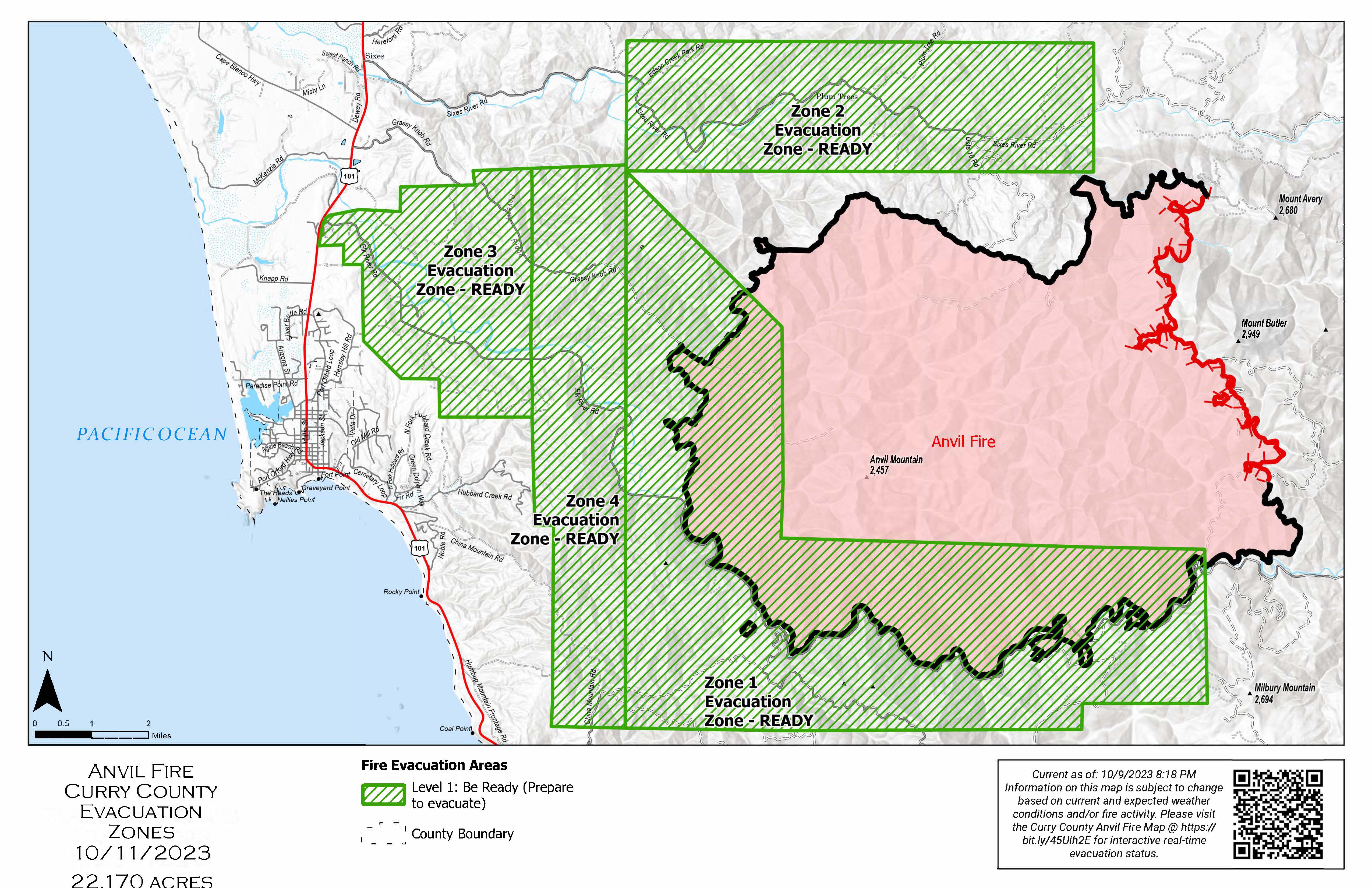
Informacin actual para los incendios Anvil y Flat 12 de octubre 2023
Related Incident: Anvil FireFlat Fire
Publication Type: News
Incendio Anvil
Área: 22,170 acres Fecha de inicio: 25 de agosto, 2023 Localizado: 8 millas Este de Port Orford, OR
Contenido: 80% Personal: 512 Recursos: 13 escuadrillas de bomberos, 1 helicópteros, 9 camiones de bomberos
El día de ayer, la lluvia y las condiciones húmedas detuvieron un poco las operaciones en general. Las escuadrillas de bomberos excavaron las características para el control de erosión ubicadas en las líneas de buldóceres en Grassy Knob. Asimismo, continuaron astillando, limpiando alcantarillas e identificando cualquier otra reparación adicional requerida en el área. El día de hoy, los bomberos tomaran ventaja del clima cálido y seco antes de que se presenten más lluvias. En el lado Norte, los bancos de tierra que fueron creados con las líneas de buldóceres serán aplanadas y todas las ramas serán esparcidas o astilladas para ayudar a prevenir la erosión. Se continuará con la extracción de escombros en las alcantarillas, con el astillado y el procesamiento de la vegetación a lo largo de la carretera forestal 5502. Se proseguirá con la reparación de las líneas de buldóceres en el área de China Mountain.
Evacuaciones: Se encuentra en pie el Nivel de Evacuación 1 en las zonas alrededor del Incendio Anvil. No hay estados de Evacuación para el Incendio Flat. Puede ver un mapa interactivo de Evacuación en:
https://bit.ly/AnvilEvacs. Inscríbase en Alertas de Emergencia para el Condado de Curry en: https://bit.ly/CurryCoEM.
Incendio Flat
Área: 34,242 acres Inicio:15 de agosto, 2023 Localizado: 2 millas Sureste de Agness, OR
Contención: 93% Personal: 32 Recursos: 1 escuadrilla de bomberos.
Los bomberos continuaran el proceso de astillado a lo largo de la carretera forestal 3680 para limpiar la vegetación que fue cortada durante la supresión del incendio.
Las áreas para Emergencia de Incendio y las Ordenes de Cierre de Carreteras aún se encuentran en efecto:
Permanecen en pie la Orden de Cierre en el Bosque para ambos incendios. Se dio un cambio en la Orden de Emergencia de cierre de Área y carreteras para el incendio Flat, reduciendo el tamaño del área afectada por dicha orden y adyacente al área del incendio. La orden se dio en efecto el 3 de octubre, 2023 y rescinde el 31 de diciembre, 2023, a menos que sea anulada antes de esa fecha. Puede encontrar mapas e información más detallada en: https://bit.ly/RRSNFAlerts o https://inciweb.wildfire.gov/incident-closures/orrsf-anvil-fire
Restricciones: El Bosque Nacional de Rogue River Siskiyou, levanto todas las Restricciones en las tierras del bosque para uso del público y movió a un nivel de peligro de incendio “Bajo”. El Nivel de Precaución de Incendios se encuentra a un Nivel 1.
Condiciones climáticas: El día de hoy, las condiciones del tiempo serán cálidas y secas. Sin la presencia prolongada de un periodo seco, se espera un comportamiento mínimo del incendio. Sin embargo, la presencia de lluvia pronosticada para los próximos días limitara el trabajo a realizar por la maquinaria pesada en el área del incendio.
Condiciones del humo: Debido a la presencia de la lluvia que ha eliminado el humo sobre el área, ya no se estará informando el pronóstico de las condiciones del humo en la zona afectada. La información acerca de la calidad del aire está disponible en: www.OregonSmoke.org.
Lnea Informativa: (541) 216-4579
Email: 2023.anvil@firenet.gov
Facebook: facebook.com/flatfireoregon2023
X/Twitter:twitter.com/RRSNF
Inciweb Anvil Fire: bit.ly/AnvilFireOR
Inciweb Flat Fire: bit.ly/FlatFireOR
Oct 12 Update French Meadows Rice Creek Underburn
Related Incident: French Meadows - Rice Creek Underburn
Publication Type: Announcement
Ignitions currently on hold due to precipitation received over the planned unit. Ignitions likely to pick-up as the unit dries out.
Settings - change map background and toggle additional layers
Filter - control incident types displayed on map.
Zoom to your location
Reset map zoom and position
Could not determine your location.
Show Legend
 Wildfire
 Prescribed Fire
 Burned Area
Response
Burned Area
Response Other
Other
2023 - Sourgrass RX Burn
Unit Information
Incident Contacts
Oct 12 Update Burlington Pileburn
Related Incident: Burlington Pileburn
Publication Type: Announcement
50 acres of piles were completed yesterday, Oct. 11. Ignitions will continue today.
Anvil and Flat Fires Update October 12 2023
Related Incident: Anvil FireFlat Fire
Publication Type: News
Anvil Fire
Size: 22,170 acres Start Date: August 25, 2023 Location: 8 miles east of Port Orford, OR
Containment: 80% Total personnel: 512 Resources: 13 crews, 1 helicopter, 9 engines
Rain and wet conditions slowed operations throughout the day yesterday. Crews dug erosion control features into dozer line on Grassy Knob and continued chipping, cleaning culverts and scouting for additional repair needs across the fire area. Today crews will take advantage of warmer and drier weather before the next round of rain arrives. On the north side, dirt berms created from dozer line will be smoothed out and any remaining brush will be scattered or chipped to prevent erosion. Removal of debris from culverts, chipping, and processing of brush will continue along the Forest Service 5502 road. Dozer line repair will also continue in the China Mountain area.
Evacuations: Level I evacuation zones around the Anvil Fire remain. There are no evacuation statuses on the Flat Fire. View the interactive evacuation map at https://bit.ly/AnvilEvacs. Sign up for Curry Co. emergency alerts at https://bit.ly/CurryCoEM.
Flat Fire
Size: 34,242 acres Start Date: July 15, 2023 Location: 2 miles southeast of Agness, OR
Containment: 93% Total personnel: 32 Resources: 1 crew
Chipping will continue along the Forest Service 3680 road to clean up brush that was cut during suppression.
Emergency Fire Area and Road Closures Still in Effect: Forest closures remain in place in both fire areas. There is an update to the Emergency Area and Road Closure for the Flat Fire, reducing the closure area and reopening roads adjacent to the fire area. The new order is effective October 3, 2023 through December 31, 2023 unless rescinded sooner. For current closure information and maps, please visit: https://bit.ly/RRSNFAlerts or https://inciweb.wildfire.gov/incident-closures/orrsf-anvil-fire.
Restrictions: The Rogue River-Siskiyou National Forest lifted all Public Use Restrictions on Forest Service lands and moved to "low" fire danger. The Industrial Fire Precaution Level was reduced to Level 1.
Weather: Today will be warmer and drier before wet weather returns. Without a period of prolonged drying, fire behavior is expected to be minimal. Forecast rain over the next few days may limit work by heavy equipment in the fire areas.
Smoke: Due to rain and lack of smoke, a daily smoke outlook no longer will be provided. Air quality information is available at www.OregonSmoke.org.
Contact Fire Information: (541) 216-4579
Email: 2023.anvil@firenet.gov
Facebook: facebook.com/flatfireoregon2023
X/Twitter:twitter.com/RRSNF
Inciweb Anvil Fire: bit.ly/AnvilFireOR
Inciweb Flat Fire: bit.ly/FlatFireOR
October 12 2023 Pile Burn Update
Related Incident: Lolo National Forest Prescribed Fire Operations
Publication Type: Announcement
Pending favorable conditions, firefighters on the Lolo National Forest will continue to burn piles today to reduce hazardous fuels from previous vegetation management operations. Pile burning reduces hazardous fuels and is a key component of the Wildfire Crisis Strategy.
Ninemile Ranger District: Firefighters plan to burn several piles located 3 miles west of Tarkio, south of Interstate 90. Smoke may be visible from Tarkio and Interstate 90.
Plains/Thompson Falls Ranger District: Firefighters will be burning piles 9 miles north of Thompson Falls. Smoke may be visible from Thompson Falls.
Superior Ranger District: The 20-acre pile burn will occur 6 miles east of Lozeau. Smoke may be visible from Superior and I-90.
Firefighters will continue to monitor the area during and after the burn.
Fire Crews Plan to Begin Ignitions Oct 13
Related Incident:
Publication Type: News
Oct. 11, 2023 - Fire crews are planning to move forward with ignitions on the McCrystal Rock Prescribed Fire on Oct. 13, when forecasts show a significant decrease in winds and increase in relative humidity.
Crews will first conduct a test fire to evaluate fire behavior. If the test is successful, ignitions within the 6,333-acre prescribed fire unit will continue and last two to three days. They will reevaluate weather and conditions, as well continue test fires, each day of ignitions.
Fire managers will postpone plans if weather and conditions change.
Previously: Prescribed Fire in Valle Vidal Tentatively Scheduled
Mendocino National Forest prepares for more prescribed burning this fall
Related Incident: Mendocino NF Fall 2023/Spring 2024 RX Fire Projects
Publication Type: News
WILLOWS, Calif., Oct. 6, 2023 — Forest personnel are planning several prescribed fire operations at campgrounds and administrative sites this fall and winter, as weather patterns shift to cooler temperatures and wetter conditions.
Work began on the ground last week with successful ignitions on the Grindstone Ranger District at the Red Bluff Recreation Area. Grindstone District fire personnel are starting with pile burns in higher elevations and will be moving down to lower elevations as weather conditions permit. Today and through the weekend, firefighters are burning piles at the Letts Lake and Mill Valley campgrounds.
Next week, Upper Lake Ranger District fire personnel will potentially burn 40 acres of piles in the Lake Pillsbury basin or 20-130 acres of understory burning at Howard Mill, depending on weather conditions.
Fire managers conduct prescribed fire activities during the safest possible “burn windows” in the coming months. Numerous factors including wind, humidity, air quality, fuel moisture and availability of fire crew personnel must be met before crews are authorized to move forward with burning.
Residents and visitors are asked to avoid areas where prescribed fires are being conducted. Some smoke may be visible. Fires are carefully monitored. Local fire and government authorities are notified prior to burn days and kept informed throughout operations.
Prescribed fire is a tool that uses fire under planned ignitions to mimic the natural role of fire in the environment. Without fire, hazardous fuels can build up and carry wildfire from the forest floor to tree canopies, creating extreme fire behavior that poses risk to firefighters, surrounding communities and natural resources.
Maps, locations, photos and updates on planned prescribed burn activities will be available on Inciweb at https://bit.ly/MNF-2023-RX.