
Oct 11 Update Yuba Underburn
Related Incident: Yuba-Unit D
Publication Type: Announcement
Precipitation was received over the underburn unit. Further ignitions are on hold until the unit dries out.
Oct 11 Update Sagehen Hills Underburn
Related Incident: Sagehen Hills Underburn
Publication Type: Announcement
.13" of precipitation was received over the underburn unit. Further igntions are on hold until conditions dry out.
Settings - change map background and toggle additional layers
Filter - control incident types displayed on map.
Zoom to your location
Reset map zoom and position
Could not determine your location.
Show Legend
 Wildfire
 Prescribed Fire
 Burned Area
Response
Burned Area
Response Other
Other
Burlington Pileburn
Unit Information
Incident Contacts
Quarry Fire Daily Update Oct 11
Related Incident: 2023-STF-Quarry Fire
Publication Type: Announcement
Quarry Fire Update
Wednesday, October 11th, 2023
Stanislaus National Forest
Incident Management Team (Type-3)
PIO Contacts:
Phyllis Ashmead - phyllis.ashmead@gmail.com
steve lyon - slyon@nps.gov
Fire Statistics:
Location: The Quarry Fire is located on the Stanislaus National Forest, Mi-Wok Ranger District, off Forest Road 3N01, east of Bourland Creek and near the Emigrant Wilderness west of Cherry Creek.
Acres Burned to Date: 6,553
Cause: Lightning
Containment: 41%
Total Personnel: 79
Current Activities: Yesterday, crews conducted a combination of ground and aerial ignitions using unmanned aerial system (drone) burning in the area west of Bourland Mountain and between Rock Creek and Lily Creek. They cleaned up existing areas of unburned pockets of fuels and looked for opportunities to expand the fire’s foot print.
Background: The Quarry fire was one of 42 fires ignited by lightning strikes across the forest on September 9, 2023. District fire managers immediately worked to ensure these naturally ignited fires stayed within pre-determined boundaries. Fire personnel with the Stanislaus National Forest are currently managing the Quarry Fire to achieve multiple resource objectives.
Closures: Soft closures are in effect to provide for the safety of the public utilizing public lands as well as fire personnel working in the area. The soft closures are an encouragement for the public to stay clear of the area, to find alternate routes to their locations and to provide fire personnel the widest berth possible as they go about their mission.
With the public’s cooperation, we will continue to monitor the number and duration of each, recognizing that fire personnel and public safety is the focus.
As of October 10, 2023, the following soft closures are in effect:
2N71 where it meets 3N16
3N21 where it meets 3N16
3N21 where it meets 3N01
3N22 where it meets 3N01
3N17 where it meets 3N29
3N29 to 3N29C
3N16
3N34Y
3N01H
3N01J
3N01L
Smoke: The amount of smoke in the air is carefully planned for. Burn Bosses are in close alignment with and get approvals from the Tuolumne County Pollution Control District (link) each day to burn the maximum amount of acreage that will not negatively impact air quality to an unsafe level. Additionally, firefighters monitoring smoke are staged around the vicinity of the fire to adjust tactics to minimize smoke impacts.
If possible, minimize outdoor activity if you are sensitive to smoke. Smoke does tend to settle in low-lying areas in the evenings to the mornings, so camping and recreating in this vicinity is not advised. To check air quality, visit fire.airnow.gov.
More Information:
INCIWEB - Quarry Fire Info - https://inciweb.wildfire.gov/incident-information/castf-2023stfquarry-fire
Stanislaus National Forest – Official Website - https://www.fs.usda.gov/stanislaus
Air Quality Info - http://fire.airnow.gov
Informacin actual para los incendios Anvil y Flat 11 de octubre 2023
Related Incident: Anvil FireFlat Fire
Publication Type: News
Incendio Anvil
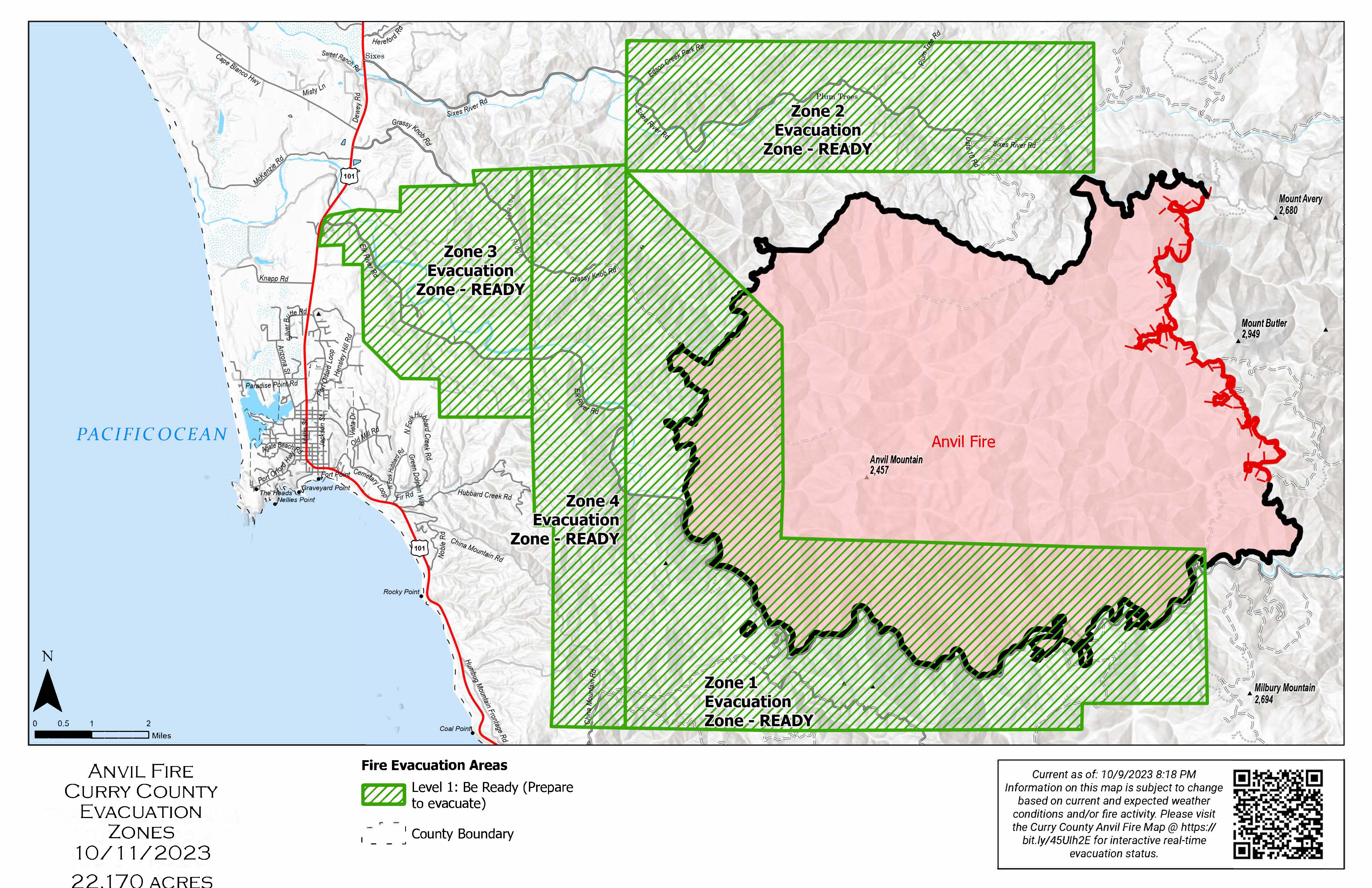
Área: 22,170 acres Fecha de inicio: 25 de agosto, 2023 Localizado: 8 millas Este de Port Orford, OR
Contenido: 80% Personal: 542 Recursos: 14 escuadrillas de bomberos, 2 helicópteros, 9 camiones de bomberos
El día de ayer, la lluvia persistente detuvo un poco las operaciones en el incendio. Los bomberos se enfocaron en establecer las prioridades en la reparación y en el número apropiado de recursos requeridos para cumplir con sus objetivos. Las escuadrillas de bomberos removieron los anuncios y señales acerca del incendio alrededor del criadero de peces y trabajaron en la reparación de las líneas manuales al Norte del incendio. El día de hoy, los operadores de la maquinaria pesada continúan con las líneas de reparación cerca de Grassy Knob para limitar el potencial de la erosión en el futuro. Si las condiciones climáticas lo permiten, las líneas de reparación de buldóceres también continuaran realizándose en el área de China Mountain. Asimismo, se proseguirá con procesos adicionales y con el apilamiento de ramas que fueron cortadas durante los esfuerzos de supresión al Sur del Incendio. El Grupo para el Manejo de Incidentes continuara con la evaluación de los recursos y los ajustes necesarios para un nivel apropiado de trabajadores.
Evacuations Level I evacuation zones around the Anvil Fire remain. There are no evacuation statuses on the Flat Fire. View the interactive evacuation map at https://bit.ly/AnvilEvacs. Sign up for Curry Co. emergency alerts at https://bit.ly/CurryCoEM.
Incendio Flat
Área: 34,242 acres Inicio:15 de agosto, 2023 Localizado: 2 millas Sureste de Agness, OR
Contención: 93% Personal: 33 Recursos: 1 escuadrilla de bomberos.
Los bomberos trabajaron en la reparación a lo largo del Sendero de Pine Grove Bike el cual fue utilizado como una característica de contención durante los esfuerzos de supresión del incendio. Se proseguirá con el astillado a lo largo de la carretera 3680.
Las áreas para Emergencia de Incendio y las Ordenes de Cierre de Carreteras aún se encuentran en efecto:
Permanecen en pie la Orden de Cierre en el Bosque para ambos incendios. Se dio un cambio en la Orden de Emergencia de cierre de Área y carreteras para el incendio Flat, reduciendo el tamaño del área afectada por dicha orden y adyacente al área del incendio. La orden se dio en efecto el 3 de octubre, 2023 y rescinde el 31 de diciembre, 2023, a menos que sea anulada antes de esa fecha. Puede encontrar mapas e información más detallada en: https://bit.ly/RRSNFAlerts o https://inciweb.wildfire.gov/incident-closures/orrsf-anvil-fire
Restricciones: El Bosque Nacional de Rogue River Siskiyou, levanto todas las Restricciones en las tierras del bosque para uso del público y movió a un nivel de peligro de incendio “Bajo”. El Nivel de Precaución de Incendios se encuentra a un Nivel 1.
Condiciones climáticas: Se espera la presencia de lluvias y viento para los próximos días lo cual podría limitar el trabajo del equipo pesado en las áreas del incendio.
Condiciones del humo: Debido a la presencia de la lluvia que ha eliminado el humo sobre el área, ya no se estará informando el pronóstico de las condiciones del humo en la zona afectada. La información acerca de la calidad del aire está disponible en: www.OregonSmoke.org.
Línea de información: (541) 216-4579
Email: 2023.anvil@firenet.gov
Facebook: facebook.com/flatfireoregon2023
X/Twitter:twitter.com/RRSNF
Inciweb Anvil Fire: bit.ly/AnvilFireOR
Inciweb Flat Fire: bit.ly/FlatFireOR
Anvil and Flat Fires Update October 11 2023
Related Incident: Anvil FireFlat Fire
Publication Type: News
Anvil Fire
Size: 22,170 acres Start Date: August 25, 2023 Location: 8 miles east of Port Orford, OR
Containment: 80% Total personnel: 542 Resources: 14 crews, 2 helicopters, 9 engines
Yesterday persistent rain slowed operations throughout the day. Firefighters focused on establishing priorities for repair work and the appropriate number of resources required to accomplish their tasks. Crews removed remaining flagging and signage around the fish hatchery and worked on handline repair north of the fire. Today heavy equipment operators are continuing dozer line repair near Grassy Knob to limit potential future erosion. Dozer line repair will also continue in the China Mountain area as weather permits. Additional processing and piling of brush that was cut for suppression efforts will continue south of the fire. The incident management team will continually evaluate resource needs and adjust for the appropriate staffing levels.
Evacuations Level I evacuation zones around the Anvil Fire remain. There are no evacuation statuses on the Flat Fire. View the interactive evacuation map at https://bit.ly/AnvilEvacs. Sign up for Curry Co. emergency alerts at https://bit.ly/CurryCoEM.
Flat Fire
Size: 34,242 acres Start Date: July 15, 2023 Location: 2 miles southeast of Agness, OR
Containment: 93% Total personnel: 33 Resources: 1 crew
Crews worked on repair along the Pine Grove Bike Trail that was used as a containment feature during the suppression effort. Chipping will continue along the 3680 road.
Emergency Fire Area and Road Closures Still in Effect:
Forest closures remain in place in both fire areas. There is an update to the Emergency Area and Road Closure for the Flat Fire, reducing the closure area and reopening roads adjacent to the fire area. The new order is effective October 3, 2023 through December 31, 2023 unless rescinded sooner. For current closure information and maps, please visit: https://bit.ly/RRSNFAlerts or https://inciweb.wildfire.gov/incident-closures/orrsf-anvil-fire.
Restrictions: The Rogue River-Siskiyou National Forest lifted all Public Use Restrictions on Forest Service lands and moved to "low" fire danger. The Industrial Fire Precaution Level was reduced to Level 1.
Weather: Rain and wind is expected over the next few days and may limit work by heavy equipment in the fire areas.
Smoke: Due to rain and lack of smoke, a daily smoke outlook no longer will be provided. Air quality information is available at www.OregonSmoke.org.
Contact Fire Information: (541) 216-4579
Email: 2023.anvil@firenet.gov
Facebook: facebook.com/flatfireoregon2023
X/Twitter:twitter.com/RRSNF
Inciweb Anvil Fire: bit.ly/AnvilFireOR
Inciweb Flat Fire: bit.ly/FlatFireOR
Prescribed Fires Around Canjilon Tentatively Scheduled
Related Incident:
Publication Type: News
Oct. 11, 2023—Carson National Forest personnel are preparing to potentially begin prescribed fire operations in the Canjilon Wildland Urban Interface Project next week. Ignitions on 899-acre Montoya and 841-acre Blas units could start as early as Monday, Oct. 16, but the timing will ultimately be based on weather and on-site conditions in consultation with a meteorologist.
Fire crews are planning implement the project over five to seven days to limit smoke impacts. When fire is excluded from areas in the forest, surface fuels accumulate and a first entry prescribed fire will generally produce considerable smoke. In the future, when crews conduct subsequent prescribed fires in the same area, less smoke is expected.
“The work around Canjilon has truly been collaborative,” said District Ranger Angie Krall. “Local residents and the State of New Mexico have been major players in and around the Forest Service lands.”
Since 2011, Forest Service staff and partners have been thinning and applying prescribed fire around the communities of Canjilon and Placita Garcia, which are completely surrounded by Carson National Forest. Many adjacent private landowners, with the assistance of the state, are contributing by thinning and applying prescribed fire on their properties. A map that shows how the Montoya and Blas units fit into the bigger picture is available online.
If a future wildfire reaches the area after treatments are completed, the fire behavior will likely be modified to a less intense, more manageable surface fire.
The Canjilon project is part of the 3.8 million-acre Rio Chama Collaborative Forest Landscape Restoration Project, which supports the national Wildfire Crisis Strategy.
The public can get prescribed fire updates on InciWeb, New Mexico Fire Information and Carson National Forest social media channels (Facebook, X).
North 287 Complex 10112023 Update 900 AM
Related Incident:
Publication Type: News
North 287 Complex Fire
Size: 592 acres
Containment: 90%
Cause: Undetermined
Yesterday, October 10 at approximately 3:00 pm, two fires started in the bar ditch off of Highway 287 North of the Canadian River. Texas A&M Forest Service was requested and worked in unified command with Potter County Fire/Rescue. There were two separate fires burning so this incident was listed as a complex wildfire, the NE Fire and the SE Fire. Heavy equipment was able to put containment line around the SE Fire and keeping it contained until moving to the NE Fire. On the NE Fire Motor Graders were utilized to put in line and burnout operations took place where fire fighters set fire to unburned portions to create a better holding position against the fire. Topography was the main difficulty, but heavy equipment was still able to get around.
For today, October 11, resources will be out on the fire to monitor and patrol for any heats or areas of concerns. There are no reported losses and no injuries from this incident.
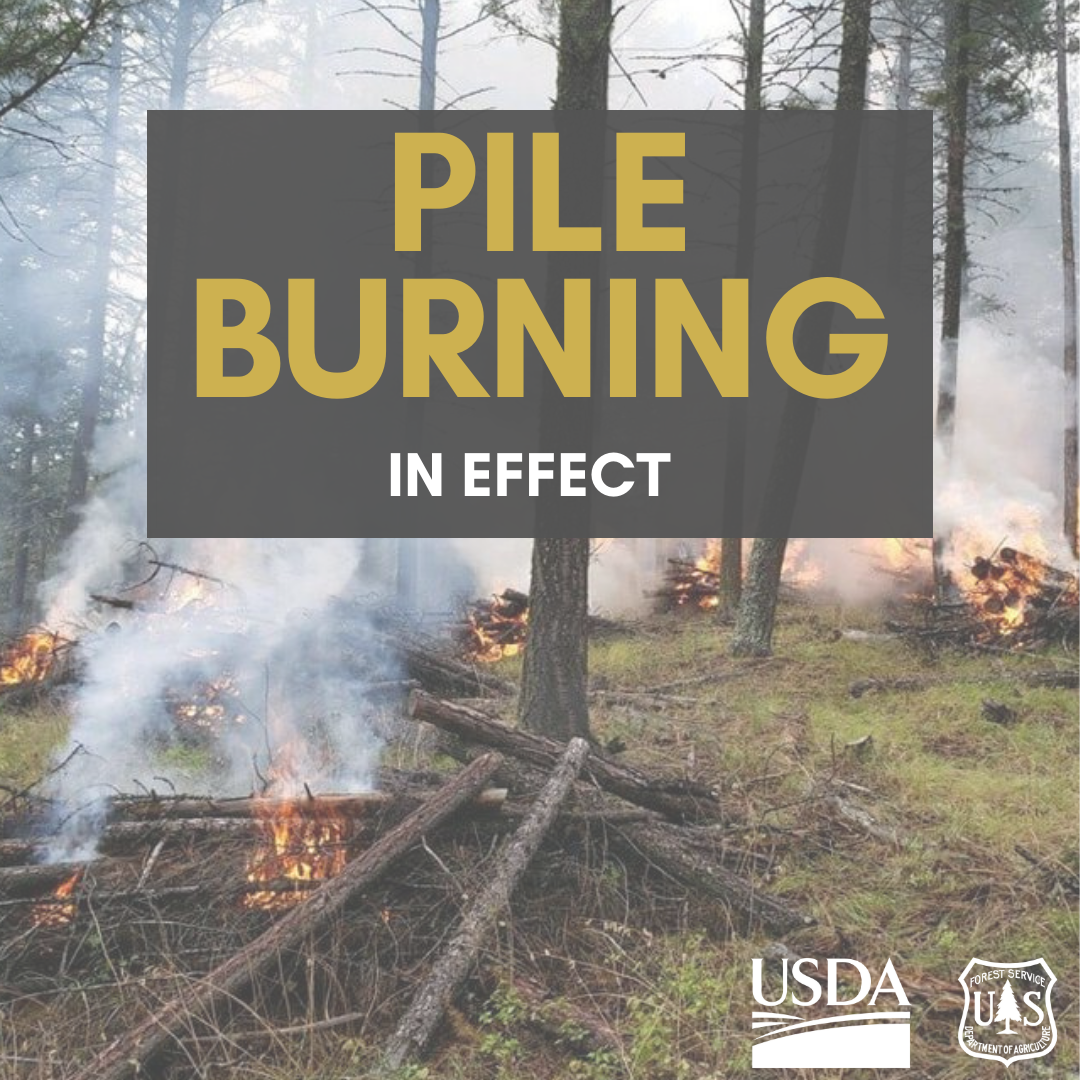
October 11 2023 Prescribed Fire Update
Related Incident: Lolo National Forest Prescribed Fire Operations
Publication Type: Announcement
Yesterday was a successful day of prescribed fire operations (pile burning) across the forest, work will continue today. Burning piles reduces hazardous fuels and contributes to the implementation of the Wildfire Crisis Strategy.
Missoula Ranger District: Firefighters will conduct up to 25 acres of hand pile burning located north of Pattee Canyon Picnic area in Pattee Canyon. Smoke may be visible from the Missoula, Bonner, and parts of the I-90 corridor.
Ninemile Ranger District: Firefighters will conduct up to 20 acres of hand pile burning located 4 miles west of the Ninemile district office. Smoke may be visible from the Ninemile Valley, Alberton and Interstate 90.
Plains/Thompson Falls Ranger District: Firefighters will be burning several piles around the Plains and Thompson Falls District Office and one large pile located two miles northwest of Plains. Smoke may be visible from Plains and Thompson Falls.
Superior Ranger District: The 30-acre pile burn will occur 10 miles east of Superior. Smoke may be visible from Superior, Alberton, Ninemile, and I-90.
Pile burning is commonly used to mitigate wildfire risk in areas where broadcast burning may not be feasible, such as adjacent to communities or private lands. Piles are made from the residual woody debris often left after a mechanical thinning treatment and can range in size from small hand stacked piles to large piles created with mechanical equipment. Piles are typically burned in fall, winter, or early spring after the piles have dried out and conditions allow, reducing the damage to the remaining trees and confining the majority of fire to the footprint of the pile.

Settings - change map background and toggle additional layers
Filter - control incident types displayed on map.
Zoom to your location
Reset map zoom and position
Could not determine your location.
Show Legend
- Wildfire
- Prescribed Fire
- Burned Area
Response
- Other