
Oct 10 Update Sagehen Hills Underburn
Related Incident: Sagehen Hills Underburn
Publication Type: Announcement
Crews continued to secure previously ignited units with all areas consuming within prescription. No ignitions are planned today. Staff will be monitoring weather conditions and evaluating opportunities to continue ignitions after the active weather pattern and winds subside. Smoke impacts will be very minimal today with residual smoke from interior combustion.
Morning Update Tuesday October 10 2023
Related Incident: Lookout Fire
Publication Type: News
Lookout, Bedrock, Petes Lake, Horse Creek and Pothole Fires
Tuesday, October 10, 2023 – Morning Update – 9:00 a.m.
Lookout Fire - Size: 25,754 acres | Start Date: August 5 | Cause: Lightning | Containment: 60%
Bedrock Fire - Size: 31,590 acres | Start Date: July 22 l Cause: Under Investigation l Containment: 100%
Petes Lake Fire - Size: 3,254 acres | Start Date: August 25 | Cause: Lightning | Completion: 80%
Horse Creek Fire - Size: 763 acres | Start Date: August 24 | Cause: Lightning | Containment: 100%
Pothole Fire - Size: 109 acres | Start Date: August 25 | Cause: Lightning | Containment: 100%
Total Assigned Personnel: 175 | 2 engines | 1 crew | 2 water tenders
(Springfield, Ore.) – Yesterday, crews completed chipping operations on the east side of the Lookout Fire. Resource advisors and crews are finalizing work on the remaining suppression repair projects. Backhaul operations and woody debris removal continue. While crews continue to work on the Lookout Fire, it has minimal fire behavior that is expected to further decrease with forecasted precipitation. The Bedrock Fire is in patrol status and the Petes Lake, Horse Creek and Pothole Fires are all in monitor status. Local units will continue these efforts. Over the past two weeks, fire managers have focused on the repair of fire lines and roads, the reduction of fuel loads and the restoration of infrastructure to point the forest in a trajectory towards a healthy recovery.
Today at 6 p.m., after a day of sharing information about the incident with the incoming team, Northwest Incident Management Team 10 (NWIMT 10) will transfer command to a Type 3 incident management team from the Willamette National Forest. Incident Commander Alan Lawson and the other members of NWIMT 10 extend their appreciation to the Willamette National Forest and other partners for their cooperation and assistance. The team also thanks residents, business owners and visitors for their support and is especially grateful to the fire camp’s neighbors for their patience and understanding.
This will be the final daily update for the Lookout, Bedrock, Petes Lake, Horse Creek, and Pothole Fires unless conditions change.
After 6 p.m. today, the incident’s email, telephone and Facebook pages will no longer be monitored. All inquiries for fire information should be directed to the McKenzie River Ranger District Office of the Willamette National Forest.
Phone: (541) 822-3381
Weather: Weather systems are expected to bring an additional 1 – 2 inches of rain over the next two days with strong southwesterly winds predicted Tuesday.
Forest Closures: Established closures on the Willamette National Forest remain in place around fire-impacted areas. The public is urged to “Know Before You Go” by visiting the Willamette National Forest official webpage. For specific hunting-related questions, contact Oregon Department of Fish and Wildlife at (503) 947-6000.
Safety: Hazards in and around fire-impacted areas include danger trees, falling rocks, rolling debris and unstable slopes. The public is asked to stay clear of the fires’ footprints and to continue exercising caution along roadways around the fire areas especially where operations are ongoing.
Quarry Fire Daily Update Oct 10
Related Incident: 2023-STF-Quarry Fire
Publication Type: Announcement
Quarry Fire Update
Tuesday, October 10th, 2023
Stanislaus National Forest
Incident Management Team (Type-3)
PIO Contacts:
Eugenie Moore - eugenie.moore@usda.gov
Phyllis Ashmead - phyllis.ashmead@gmail.com
steve lyon - slyon@nps.gov
Fire Statistics:
Location: The Quarry Fire is located on the Stanislaus National Forest, Mi-Wok Ranger District, off Forest Road 3N01, east of Bourland Creek and near the Emigrant Wilderness west of Cherry Creek.
Acres Burned to Date: 6,501
Cause: Lightning
Containment: 41%
Total Personnel: 85
Current Activities: Yesterday, no fire growth – weather and wind precluded any aggressive lighting. Crews worked to clear out interior areas of dead and down, cleaned up along the north end of the fire perimeter, and cleaned up unburned pockets. Unmanned Aerial System (drone) operations found mixed success with lighting operations, but the fire perimeter did not increase.
Background: The Quarry fire was one of 42 fires ignited by lightning strikes across the forest on September 9, 2023. District fire managers immediately worked to ensure these naturally ignited fires stayed within pre-determined boundaries. Fire personnel with the Stanislaus National Forest are currently managing the Quarry Fire to achieve multiple resource objectives.
Closures: Soft closures are in effect to provide for the safety of the public utilizing public lands as well as fire personnel working in the area. The soft closures are an encouragement for the public to stay clear of the area, to find alternate routes to their locations and to provide fire personnel the widest berth possible as they go about their mission.
With the public’s cooperation, we will continue to monitor the number and duration of each, recognizing that fire personnel and public safety is the focus.
As of October 10, 2023, the following soft closures are in effect:
2N71 where it meets 3N16
3N21 where it meets 3N16
3N21 where it meets 3N01
3N22 where it meets 3N01
3N17 where it meets 3N29
3N29 to 3N29C
3N16
3N34Y
3N01H
3N01J
3N01L
Smoke: The amount of smoke in the air is carefully planned for. Burn Bosses are in close alignment with and get approvals from the Tuolumne County Pollution Control District (link) each day to burn the maximum amount of acreage that will not negatively impact air quality to an unsafe level. Additionally, firefighters monitoring smoke are staged around the vicinity of the fire to adjust tactics to minimize smoke impacts.
If possible, minimize outdoor activity if you are sensitive to smoke. Smoke does tend to settle in low-lying areas in the evenings to the mornings, so camping and recreating in this vicinity is not advised. To check air quality, visit fire.airnow.gov.
More Information:
INCIWEB - Quarry Fire Info - https://inciweb.wildfire.gov/incident-information/castf-2023stfquarry-fire
Stanislaus National Forest – Official Website - https://www.fs.usda.gov/stanislaus
Air Quality Info - http://fire.airnow.gov
Informacin actual para los incendios Anvil y Flat 10 de octubre 2023
Related Incident: Anvil FireFlat Fire
Publication Type: News
Incendio Anvil
Área: 22,170 acres Fecha de inicio: 25 de agosto, 2023 Localizado: 8 millas Este de Port Orford, OR
Contenido: 77% Personal: 561 Recursos: 14 escuadrillas de bomberos, 2 helicópteros, 13 camiones de bomberos
El día de hoy, el Grupo 12 Northwest asumió el comando de los Incendios Anvil y Flat. Los bomberos continuaron trabajando activamente en la reparación y en la limpieza tanto como las condiciones climáticas lo permitieron. Se logro contener un poco más el perímetro a lo largo del área Norte. Vuelos infrarrojos no mostraron fuentes de calor a lo largo del eje Este. Se continuará con el monitoreo del área. El día de hoy, los bomberos que trabajan manualmente apilaron ramas sobre la línea Norte y continuaran con este trabajo el día de hoy. La maquinaria excavadora iniciara la labor de reparación y cerrando las líneas de buldóceres en el área de China Mountain con el objetivo de reducir el potencial de erosión en el futuro. Dependiendo de las condiciones climáticas, se estará prosiguiendo con el trabajo de astillado a lo largo de la carretera 5502.
Evacuaciones: Se encuentra en pie el Nivel de Evacuación 1 en las zonas alrededor del Incendio Anvil. No hay estados de Evacuación para el Incendio Flat. Puede ver un mapa interactivo de Evacuación en:
https://bit.ly/AnvilEvacs. Inscríbase en Alertas de Emergencia para el Condado de Curry en: https://bit.ly/CurryCoEM.
Incendio Flat
Área: 34,242 acres Inicio:15 de agosto, 2023 Localizado: 2 millas Sureste de Agness, OR
Contención: 93% Personal: 51 Recursos: 3 camiones de bomberos, 1 escuadrilla de bomberos.
Los bomberos lograron reparar la alcantarilla utilizando la maquina excavadora a lo largo de la carretera 3318 cerca del sendero Lawson North y continuaran el trabajo el día de hoy si las condiciones del tiempo lo permiten.
Las áreas para Emergencia de Incendio y las Ordenes de Cierre de Carreteras aún se encuentran en efecto:
Permanecen en pie la Orden de Cierre en el Bosque para ambos incendios. Se dio un cambio en la Orden de Emergencia de cierre de Área y carreteras para el incendio Flat, reduciendo el tamaño del área afectada por dicha orden y adyacente al área del incendio. La orden se dio en efecto el 3 de octubre, 2023 y rescinde el 31 de diciembre, 2023, a menos que sea anulada antes de esa fecha. Puede encontrar mapas e información más detallada en: https://bit.ly/RRSNFAlerts o https://inciweb.wildfire.gov/incident-closures/orrsf-anvil-fire
Restricciones: El Bosque Nacional de Rogue River Siskiyou, levanto todas las Restricciones en las tierras del bosque para uso del público y movió a un nivel de peligro de incendio “Bajo”. El Nivel de Precaución de Incendios se encuentra a un Nivel 1.
Condiciones climáticas: Se espera la presencia de lluvias y viento para los próximos días lo cual podría limitar el trabajo del equipo pesado en las áreas del incendio.
Condiciones del humo: Para información actualizada en cuanto a la presencia del humo y la calidad del aire, visite: https://bit.ly/SWORsmoke. Por favor conduzca despacio y con las luces encendidas a través de cualquier área de incendio
Líneas Informativas: (541) 216-4579
Email: 2023.anvil@firenet.gov
Facebook: facebook.com/flatfireoregon2023
X/Twitter: twitter.com/RRSNF
Inciweb Anvil Fire: bit.ly/AnvilFireOR
Inciweb Flat Fire: bit.ly/FlatFireOR
2023 SRF Lightning Complex Update October 10 2023
Related Incident: 2023 SRF Lightning Complex and Redwood Lightning Complex
Publication Type: News
Fire Information: 530-618-3339
Hours: 8 a.m. to 4:30 p.m. (Mon-Fri)
Email: 2023.lightningcomplex@firenet.gov
Incident Website: inciweb.nwcg.gov/incident-information/casrf-2023-srf-lightning-complex
Vegetation: Timber (Litter and Understory) and Brush
Number of Personnel Assigned: 269
Start Date: Thursday, August 17, 2023, 1000
Location: Six Rivers National Forest
Size: 50,198 acres
Percent Contained: 75%
Cause: Lightning
ANNOUNCEMET: Some Six Rivers National Forest lands, roads, and trails around the SRF Lightning Complex fires are closed. View the Order and closure map on the Forest’s website: tinyurl.com/4atens8c.
CURRENT SITUATION: The 15 fires are being held within the lines and total containment is at 75% with the total acres burned at 50,198. The fire growth yesterday was up on Dillon Mountain, and near Lightning Gulch. The wet conditions have been favorable in moderating the fire activity but create additional challenges. These challenges include making roads slicker and the fire more difficult to access. Crews remain vigilant and continue to assess the fire from the ground and air as the fire areas dry out and accessibility improves.
Crews will continue with extensive suppression repair and road repair work. Chipping operations, scouting, and surveying is occurring across all Divisions. Positive attitudes, hard work and diligent focus by firefighters continues. Long hours spent by heavy equipment operators and crews on the ground ensure the ability to maintain the cultural and natural resources of the area.
California Interagency Incident Management Team 16 will transition command of the incident to the North Coast Interagency Incident Management Team today. This written update will distributed every other day. If fire conditions necessitate this update will return to being distributed as often as necessary.
WEATHER: Another round of rain will impact the fire area Tuesday into early Wednesday. Additional accumulations will generally be between one-half and one inch. Temperatures on both days will remain well below normal. High temperatures in the valleys will be in the 60s while temperatures on the mid-slopes and ridges will range from the mid-40s to lower 50s. Winds will be out of the southwest Tuesday with gusts of 25 to 30 mph along the ridges and exposed areas. On Wednesday, winds will shift to the northwest at between 15 to 20 mph. Humidity values will remain high throughout the period.
CLOSURES: While county roads remain open, some Six Rivers National Forest lands, roads, and trails around the Smith River Complex fires are closed (Forest Order No. 10-23-12). View the Order and closure map on the Forest’s website: tinyurl.com/4atens8c. Caltrans provides information on current highway conditions online (roads.dot.ca.gov), by phone (800-427-7623), and on Facebook (facebook.com/CaltransD1).
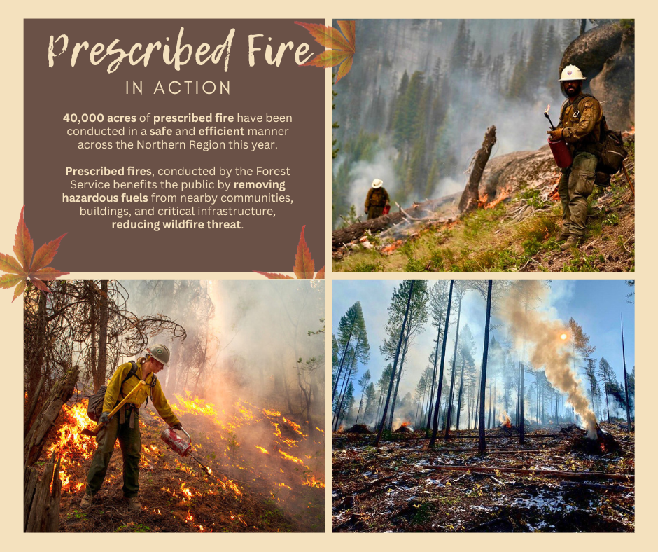
October 10 2023 Prescribed Fire Update
Related Incident: Lolo National Forest Prescribed Fire Operations
Publication Type: Announcement
Conditions permitting, several districts on the Lolo National Forest are planning to conduct prescribed fire operations today to help reduce hazardous fuels, restore wildlife habitat, and create better protection around communities from future wildfires.
Superior Ranger District: The 14-acre prescribed fire will occur 8 miles northeast of St. Regis. Residents in the 7-mile area and the Highway 135 corridor may see residual smoke overnight.
Ninemile Ranger District: Firefighters will conduct up to 45 acres of hand pile burning located 4 miles west of the Ninemile District Office in Huson, MT. Smoke may be visible from the Ninemile Valley, Alberton and Interstate 90.
Missoula Ranger District: Firefighters will conduct up to 20 acres of hand pile burning located 15 miles southeast of Missoula, MT in the Pattee Canyon Disk Golf Course area. Smoke may be visible from the Missoula, Bonner, and parts of the I-90 corridor.
Plains/Thompson Falls Ranger District: Firefighters will be burning several piles 12 miles west of Thompson Falls. Smoke may be visible from Thompson Falls.
Firefighters will patrol and monitor the burning over the next few days. Precipitation today through Thursday.

Anvil and Flat Fires Update October 10 2023
Related Incident: Anvil FireFlat Fire
Publication Type: News
Anvil Fire
Size: 22,170 acres Start Date: August 25, 2023 Location: 8 miles east of Port Orford, OR
Containment: 77% Total personnel: 561 Resources: 14 crews, 2 helicopters, 13 engines
Today, Northwest Team 12 assumed command of the Anvil and Flat Fires. Firefighters continued to engage in repair and clean-up work as weather permitted yesterday. Containment was added to the perimeter along the northern finger. Infrared flights showed no heat along the eastern edge. This area will continue to be monitored. Crews hand piled brush on the northern line and will continue that work today. An excavator will begin repairing and closing dozer lines in the China Mountain area to reduce the potential for future erosion. Chipping will continue along the 5502 Road as weather permits.
Evacuations Level I evacuation zones around the Anvil Fire remain. There are no evacuation statuses on the Flat Fire. View the interactive evacuation map at https://bit.ly/AnvilEvacs. Sign up for Curry Co. emergency alerts at https://bit.ly/CurryCoEM.
Flat Fire
Size: 34,242 acres Start Date: July 15, 2023 Location: 2 miles southeast of Agness, OR
Containment: 93% Total personnel: 51 Resources: 1 crew, 3 engines
Crews worked on culvert repair with an excavator along the 3318 Road near Lawson North trailhead and will continue that work today as weather permits.
Emergency Fire Area and Road Closures Still in Effect:
Forest closures remain in place in both fire areas. There is an update to the Emergency Area and Road Closure for the Flat Fire, reducing the closure area and reopening roads adjacent to the fire area. The new order is effective October 3, 2023 through December 31, 2023 unless rescinded sooner. For current closure
information and maps, please visit: https://bit.ly/RRSNFAlerts or https://inciweb.wildfire.gov/incident-closures/orrsf-anvil-fire.
Restrictions: The Rogue River-Siskiyou National Forest lifted all Public Use Restrictions on Forest Service
lands and moved to "low" fire danger. The Industrial Fire Precaution Level was reduced to Level 1.
Weather: Rain and wind is expected over the next few days and may limit work by heavy equipment in the fire areas.
Smoke: For current smoke and air quality updates visit, https://bit.ly/SWORsmoke. Please drive slowly and
with headlights on through any fire area.
Contact Fire Information: (541) 216-4579
Email: 2023.anvil@firenet.gov
Facebook: facebook.com/flatfireoregon2023
X/Twitter: twitter.com/RRSNF
Inciweb Anvil Fire: bit.ly/AnvilFireOR
Inciweb Flat Fire: bit.ly/FlatFireOR
2023 SRF LIGHTNING COMPLEX POSTFIRE BAER SBS MAP RELEASED
Related Incident: 2023 SRF Lightning Complex Post-Fire BAER
Publication Type: Announcement
2023 SRF LIGHTNING COMPLEX POST-FIRE BAER SBS MAP RELEASED
Forest Service Burned Area Emergency Response (BAER) team specialists recently completed their field assessments of the 2023 SRF Lightning Complex wildfires to better understand post-fire effects. The BAER team’s soil burn severity (SBS) analysis was conducted across 62,963 acres of burned areas within the complex.
The BAER assessment team starts with data derived from satellite imagery, then adds field observations and collected data to produce a post-fire SBS map. SBS map products are not an estimate of fire direct effects on vegetation, but rather an estimate of the fire effects to the soil. Soil burn severity is a good indicator of post-fire processes, because it is sensitive to the conditions that promote erosion, floods, debris flows and vegetation recovery.
Soil burn severity indicators can be found within the Rocky Mountain Research Station’s General Technical Report 243 – Field Guide for Mapping Post-Fire Soil Burn Severity https://www.fs.usda.gov/rm/pubs/rmrs_gtr243.pdf.
In general, low SBS occurs where surface organic layers are not completely consumed. Vegetation canopy and understory will often still appear “green.” These areas are at lower risk for post-fire accelerated runoff, erosion, flooding, and debris flows.
In areas with moderate SBS, much of the pre-fire ground cover is consumed. Fine roots may be scorched but are rarely completely consumed. These areas still have the potential for effective ground cover from scorched needles or leaves remaining in the canopy that will soon fall to the ground. The prevailing color of the site is often “brown” due to canopy needle and other vegetation scorch. Where greater amounts of reduced soil cover and increased water repellency occur, increased overland flow of water from precipitation is expected, most notably in locations where the overstory canopy has been removed.
High SBS occurs where all or nearly all the pre-fire ground cover and surface organic matter are consumed, and charring may be visible on larger roots. White or gray ash indicates that considerable ground cover or fuels were consumed. Sometimes very large tree roots are entirely burned extending from a charred stump hole. Soil is often gray, orange, or reddish where large fuels were concentrated and consumed. Bare soil or ash is exposed and susceptible to erosion, and overall structure may be less stable.
The BAER team estimated that approximately 69% of the SRF Lightning Complex was either unburned/very low or low SBS, 27% was moderate and 4% was high SBS. Generally burned areas with moderate and high SBS are prone to post-fire impacts. Rain events can cause excessive soil erosion, resulting in higher volumes of flooding, sediment delivery, and debris flows. These threats can individually or cumulatively increase the risk to human life and safety, property, infrastructure, and important critical natural and cultural resources.
The BAER team uses the SBS data as a foundation to model post-fire hydrologic response for each of the watersheds to determine if there are threats or risks to BAER critical values: human life and safety, property, critical natural resources, and critical cultural resources. The team collaborates and shares its analysis with local tribes, county, state and federal agencies, such as Siskiyou County and Humboldt County, State of California Department of Fish and Wildlife (CDFW), California Office of Emergency Services (CALOES), Natural Resources Conservation Service (NRCS), National Weather Service (NWS), and US Geological Survey (USGS). These agencies have the authority to work with private property owners downstream from the burned area that potentially may have post-fire threats from increased water and debris flows.
The BAER team’s analysis and findings will be documented in an assessment report that will be posted to the 2023 SRF Lightning Complex Post-Fire BAER InciWeb page after the report has been reviewed and approved by Forest Service leadership.
The SBS map can be downloaded at the 2023 SRF Lightning Complex Post-Fire BAER InciWeb site as a JPEG or PDF format image under the “Maps” tab.
For additional information about understanding SBS, see: Post-Fire Effects--Understanding Soil Burn Severity - InciWeb the Incident Information System (nwcg.gov).
BAER SAFETY MESSAGE: Everyone near and downstream from the burned areas should remain alert and stay updated on weather conditions that may result in heavy rains and increased water runoff. Flash flooding may occur quickly during heavy rain events – be prepared to act. Current weather and emergency notifications can be found at the National Weather Service websites: https://www.weather.gov/eka/ and www.weather.gov/sto/.
Quarry Fire Daily Update Oct 9
Related Incident: 2023-STF-Quarry Fire
Publication Type: Announcement
Quarry Fire Update
Monday, October 9th, 2023
Stanislaus National Forest
Incident Management Team (Type-3)
PIO Contacts:
Eugenie Moore - eugenie.moore@usda.gov
Phyllis Ashmead - phyllis.ashmead@gmail.com
steve lyon - slyon@nps.gov
Fire Statistics:
Location: The Quarry Fire is located on the Stanislaus National Forest, Mi-Wok Ranger District, off Forest Road 3N01, east of Bourland Creek and near the Emigrant Wilderness west of Cherry Creek.
Acres Burned to Date: 6,501
Cause: Lightning
Containment: 49%
Total Personnel: 105
Injuries: 0
Current Activities: Yesterday, fire crews extended containment lines into desired objective areas on the north end of the fire in the Rock Creek area using constructed lines and natural barriers, with moderate fire effects. There was no significant activity on the east side of the fire in the Cherry Creek area. The next few days should see little change to the fire due to cooler temperatures and higher humidity.
Background: The Quarry fire was one of 42 fires ignited by lightning strikes across the forest on September 9, 2023. District fire managers immediately worked to ensure these naturally ignited fires stayed within pre-determined boundaries. Fire personnel with the Stanislaus National Forest are currently managing the Quarry Fire to achieve multiple resource objectives.
Closures: Soft closures are in effect to provide for the safety of the public utilizing public lands as well as fire personnel working in the area. The soft closures are an encouragement for the public to stay clear of the area, to find alternate routes to their locations and to provide fire personnel the widest berth possible as they go about their mission.
With the public’s cooperation, we will continue to monitor the number and duration of each, recognizing that fire personnel and public safety is the focus.
As of October 9, 2023, the following soft closures are in effect:
2N71 where it meets 3N16
3N21 where it meets 3N16
3N21 where it meets 3N01
3N22 where it meets 3N01
3N17 where it meets 3N29
3N29 to 3N29C
3N16
3N34Y
3N01H
3N01J
3N01L
Smoke: The amount of smoke in the air is carefully planned for. Burn Bosses are in close alignment with and get approvals from the Tuolumne County Pollution Control District (link) each day to burn the maximum amount of acreage that will not negatively impact air quality to an unsafe level. Additionally, firefighters monitoring smoke are staged around the vicinity of the fire to adjust tactics to minimize smoke impacts.
If possible, minimize outdoor activity if you are sensitive to smoke. Smoke does tend to settle in low-lying areas in the evenings to the mornings, so camping and recreating in this vicinity is not advised. To check air quality, visit fire.airnow.gov.
More Information:
INCIWEB - Quarry Fire Info - https://inciweb.wildfire.gov/incident-information/castf-2023stfquarry-fire
Stanislaus National Forest – Official Website - https://www.fs.usda.gov/stanislaus
Air Quality Info - http://fire.airnow.gov
Morning Update Monday October 9 2023
Related Incident: Lookout FirePetes Lake Fire
Publication Type: News
(Springfield, Ore.) – Most of the work on the Bedrock Fire is now complete and firefighters are backhauling equipment ahead of forecasted precipitation. Aerial resources have retrieved the remaining communications equipment serving as radio repeaters at high points around the fires. On the Lookout Fire, chipping operations are ongoing as is removal of suppression-generated woody debris.
As this work progresses, assigned resources are being released and the fire camp on Kickbush Lane, after serving thousands of firefighters over two months, is being dismantled. The incident management team has relocated its command post to Springfield where they will continue overseeing the fires' operations.
Fire managers will in-brief a local Type 3 incident management team at 3 p.m. today. The incoming team will shadow Northwest Incident Management Team 10 and a transfer of command will take place at 6 p.m. on Tuesday.
Weather: An approaching weather system is forecast to bring significant rainfall over the next three days. Rain is expected to begin by mid-morning today, with a reinforcing system moving onshore on Tuesday bringing an additional inch of rain throughout the day. Estimated precipitation over the fire areas will bring elevated moisture content to fine and heavy fuels, significantly dampening fire behavior and potentially resulting in a wildland fire season-ending event.
Forest Closures: Established closures on the Willamette National Forest remain in place around fire-impacted areas, including the Lookout and Bedrock Fires. The public is urged to “Know Before You Go” by visiting the Willamette National Forest official webpage. For specific hunting-related questions, contact Oregon Department of Fish and Wildlife at (503) 947-6000.
Safety: Hazards in and around fire-impacted areas include danger trees, falling rocks, rolling debris and unstable slopes. The public is asked to stay clear of the fires’ footprints and to continue exercising caution along roadways around the fire areas especially where operations are ongoing.