
Informacin actual para los incendios Anvil y Flat 15 de octubre 2023
Related Incident: Anvil FireFlat Fire
Publication Type: News
Incendio Anvil
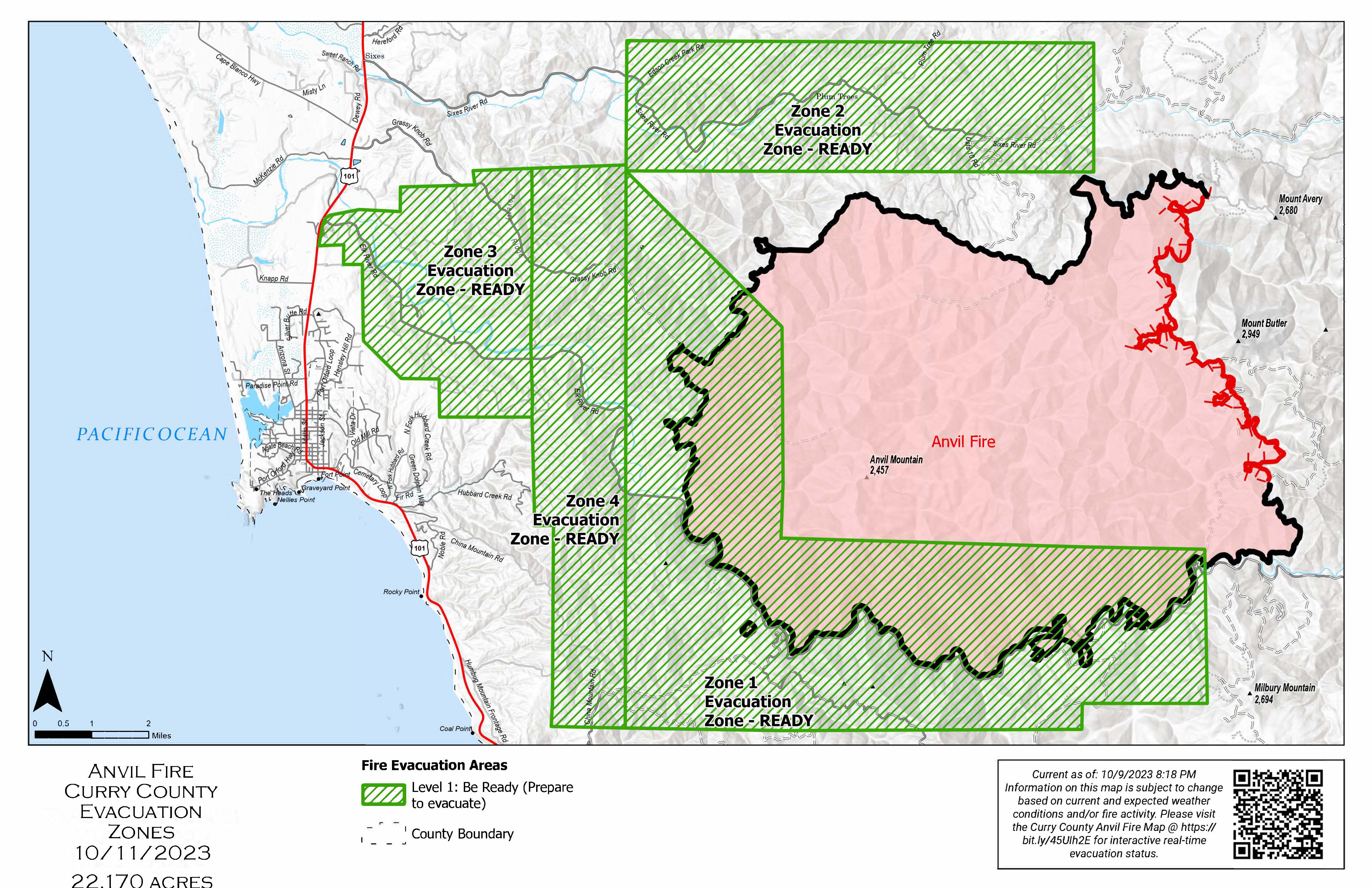
Área: 22,170 acres Fecha de inicio: 25 de agosto, 2023 Localizado: 8 millas Este de Port Orford, OR
Contenido: 80% Personal:292 Recursos: 7 escuadrillas de bomberos, 1 helicópteros, 6 camiones de bomberos
La condición húmeda continúa deteniendo la propagación del fuego. Todavía puede observarse un humo ligero al estar quemándose de manera lenta, el material de combustión pesado desde el interior del área. Las excavadoras están mitigando los impactos de las operaciones de supresión a lo largo del perímetro Noroeste, reparando las líneas de buldóceres y las carreteras. El equipo pesado y las escuadrillas de bomberos se encuentran realizando trabajos de reparación adicional incluyendo la limpieza de alcantarillas y zanjas, así como el astillado y reparando líneas de buldóceres en el área de China Mountain.
Evacuations: Level I evacuation zones around the Anvil Fire remain. There are no evacuation statuses on the Flat Fire. View the interactive evacuation map at https://bit.ly/AnvilEvacs. Sign up for Curry Co. emergency alerts at https://bit.ly/CurryCoEM.
Incendio Flat
Área: 34,242 acres Inicio:15 de julio, 2023 Localizado: 2 millas Sureste de Agness, OR
Contención: 93% Personal: 53 Recursos: 1 escuadrilla de bomberos, 4 camiones de bomberos
El día de ayer, las condiciones del tiempo fueron mas propicias para los bomberos que están llevando a cabo los esfuerzos de reparación de supresión. Se logro limpiar ciertas alcantarillas a lo largo de los caminos y se continuó procesando troncos hacia el Norte y el Este. Los bomberos trabajando manualmente, dedicaron sus esfuerzos en el sendero Pine Grove y reiniciaron las operaciones de astillado. Mañana, se presentará un periodo corto con condiciones climáticas favorables el cual será aprovechado por los bomberos para proveer pacas de heno y utilizando los helicópteros sobre las áreas al Este de Agness. Esta acción es realizada con los objetivos de proteger áreas resembradas y prevenir la erosión.
Las áreas para Emergencia de Incendio y las Ordenes de Cierre de Carreteras aún se encuentran en efecto:
Permanecen en pie la Orden de Cierre en el Bosque para ambos incendios. Se dio un cambio en la Orden de Emergencia de cierre de Área y carreteras para el incendio Flat, reduciendo el tamaño del área afectada por dicha orden y adyacente al área del incendio. La orden se dio en efecto el 3 de octubre, 2023 y rescinde el 31 de diciembre, 2023, a menos que sea anulada antes de esa fecha. Puede encontrar mapas e información más detallada en: https://bit.ly/RRSNFAlerts o https://inciweb.wildfire.gov/incident-closures/orrsf-anvil-fire
Restricciones: El Bosque Nacional de Rogue River Siskiyou, levanto todas las Restricciones en las tierras del bosque para uso del público y movió a un nivel de peligro de incendio “Bajo”. El Nivel de Precaución de Incendios se encuentra a un Nivel 1.
Condiciones climáticas: Para el día de hoy, se pronostica un clima cálido seguido el lunes con la incrementación de ráfagas de viento hasta de 40 mph. Ese mismo día, en horas tempranas de la mañana, se introducirá un frente frio y mojado produciendo hasta 1.5 pulgadas de lluvia en un periodo de 24 horas. El resto de la semana permanecerá una tendencia cálida y seca.
Condiciones del humo: Debido a la presencia de la lluvia que ha eliminado el humo sobre el área, ya no se estará informando el pronóstico de las condiciones del humo en la zona afectada. La información acerca de la calidad del aire está disponible en: www.OregonSmoke.org.
Línea de información: (541) 216-4579
Email: 2023.anvil@firenet.gov
Facebook: facebook.com/flatfireoregon2023
X/Twitter:twitter.com/RRSNF
Inciweb Anvil Fire: bit.ly/AnvilFireOR
Inciweb Flat Fire: bit.ly/FlatFireOR
Anvil and Flat Fires Update October 15 2023
Related Incident: Anvil FireFlat Fire
Publication Type: News
Anvil Fire
Size: 22,170 acres Start Date: August 25, 2023 Location: 8 miles east of Port Orford, OR
Containment: 80% Total personnel: 292 Resources: 7 crews, 1 helicopter, 6 engines
Lingering moisture continues to slow fire spread in uncontained areas of the fire. Light smoke is still visible as heavy fuels on the interior of the fire smolder. Excavators are working to mitigate impacts from suppression operations along the northwest perimeter, repairing dozer line and roads. Heavy equipment and hand crews are engaged in additional repair work including cleaning culverts and ditches, chipping, and dozer line repair in the China Mountain area.
Evacuations: Level I evacuation zones around the Anvil Fire remain. There are no evacuation statuses on the Flat Fire. View the interactive evacuation map at https://bit.ly/AnvilEvacs. Sign up for Curry Co. emergency alerts at https://bit.ly/CurryCoEM.
Flat Fire
Size: 34,242 acres Start Date: July 15, 2023 Location: 2 miles southeast of Agness, OR
Containment: 93% Total personnel: 53 Resources: 1 crew, 4 engines
Yesterday, weather conditions were more conducive for fire personnel to carry out suppression repair efforts. Excavators cleaned culverts along roads and log processing continued working to the north and east. Hand crews worked the Pine Grove bicycle trail and reengaged in chipping operations. A small window of favorable weather is possible tomorrow to deliver straw bales via helicopter to areas east of Agness which firefighters will spread to protect reseeded areas and prevent erosion.
Emergency Fire Area and Road Closures Still in Effect: Forest closures remain in place in both fire areas. There is an update to the Emergency Area and Road Closure for the Flat Fire, reducing the closure area and reopening roads adjacent to the fire area. The new order is effective October 3, 2023 through December 31, 2023 unless rescinded sooner. For current closure information and maps, please visit: https://bit.ly/RRSNFAlerts or https://inciweb.wildfire.gov/incident-closures/orrsf-anvil-fire.
Restrictions: The Rogue River-Siskiyou National Forest lifted all Public Use Restrictions on Forest Service lands and moved to "low" fire danger. The Industrial Fire Precaution Level was reduced to Level 1.
Weather: Sunday is expected to be warmer with progressively increasing winds gusting to 40 mph on Monday. Early Monday morning, a wet cold front will move in the area producing up to 1.5 inches of rain over a 24-hour period. A warming and drying trend will develop over the remainder of the week.
Smoke: Due to rain and lack of smoke, a daily smoke outlook no longer will be provided. Air quality information is available at www.OregonSmoke.org.
Contact Fire Information: (541) 216-4579
Email: 2023.anvil@firenet.gov
Facebook: facebook.com/flatfireoregon2023
X/Twitter:twitter.com/RRSNF
Inciweb Anvil Fire: bit.ly/AnvilFireOR
Inciweb Flat Fire: bit.ly/FlatFireOR
McCrystal Rock Prescribed Fire Ignitions Near Completion
Related Incident:
Publication Type: News
Fire crews treated another 2,800 acres with broadcast prescribed fire in the Valle Vidal today, wrapping up the primary ignitions in the McCrystal Rock Unit for a total of 4,000 acres this year. Tomorrow, firefighters will work to clean-up some areas in and around the edges of the burn but little to no acreage growth is expected. The remaining 2,333 acres will be addressed in the future.
“Treating 4,000 acres in two days is a major accomplishment,” said Questa District Ranger Adam LaDell. “With weather and conditions changing, we’re going to shift to patrolling and monitoring until the fire is called out.”
In the days to come, a smaller organization of fire personnel will remain in the area to continue checking the fire by walking the unit boundary, mopping up edges and monitoring any remaining interior burning.
The unit remains open, but visitors should take caution when entering a recently burned area. Smoke will be visible throughout tomorrow from the interior smoldering pockets of unburned fuels and clean-up work. Visitors are asked to slow down and drive with caution when smoke is present, or firefighters and apparatuses are working on or near the roadways.
The McCrystal Rock Unit is part of the larger 21,000-acre Valle Vidal Northeast Prescribed Fire Project. The goal is to improve wildlife habitat by, in part, promoting grassland and meadow regeneration and reducing the potential for high-severity wildfires in forested areas.
Fire-adapted forests in the Southwest must undergo fire disturbance on a regular basis to maintain resiliency. Reintroducing and maintaining regular fire intervals in the Valle Vidal, the so-called “Yellowstone of the Southwest,” is a key component of the USDA Forest Service’s Wildfire Crisis Strategy. The emphasis of the strategy is to increase fuels and forest health treatments to protect natural resources in designated landscapes, including the 1.5-million-acre Enchanted Circle Landscape in Northern New Mexico.
The public can learn more information about this prescribed fire on InciWeb, New Mexico Fire Information and Carson National Forest social media channels (Facebook, X).
2023 SRF Lightning Complex Update October 14 2023
Related Incident: 2023 SRF Lightning Complex and Redwood Lightning Complex
Publication Type: News
Fire Update
2023 SRF Lightning Complex
Saturday, October 14, 2023
Information Phone: 530-618-3339
Email: 2023.lightningcomplex@firenet.gov
Information Staffing Hours: 8 am to 4:30 pm
ANNOUNCEMENT OF REDUCTION IN FOREST CLOSURE: While county roads remain open, some Six Rivers National Forest lands, roads, and trails around the Six Rivers Lightning Complex fires are closed (Forest Order No. 10-23-13). Cedar Camp Rd is closed 15 miles from Hwy 96. Slate Creek is closed 11 miles from Hwy 96. The Klamath River is now open for recreation. View the Order and closure map on the Forest’s website: tinyurl.com/4atens8c . CalTrans provides information on current highway conditions online (roads.dot.ca.gov), by phone (800-427-7623), and on Facebook (facebook.com/CaltransD1).
CURRENT SITUATION: North Coast Interagency Incident Management Team assumed command earlier this week, with Incident Commander Rod Mendes. The fifteen fires continue being held within the lines, and total containment is at 75% with the total burned area remaining at 50,198 acres. Continued wet conditions have aided in keeping fire activity low, but present different logistical challenges for firefighters. With continued rainfall, division leaders have inspected road conditions for work viability. Crews were able to continue grading and installing rolling water bars on roads above the Pearch Creek neighborhood yesterday, as well as roads within the Mosquito Fire.
Suppression Repair will now become a priority for remaining crews. NCIMT will work closely with local Resource Advisors to minimize impacts to communities, cultural and natural resources including critical power, communications and other infrastructure, private property inholdings, Tribal Lands, Timber Lands, TESC Species, and watersheds. All resources will take advantage of opportunities as weather permits to meet the objectives of the suppression repair plan.
WEATHER: Friday saw scattered rain showers mixed with periods of sun. Today will again see scattered showers throughout the area, with temperatures in the low 70s. North winds will reach 5 to 10 mph, becoming light in the afternoon, Partly sunny most of the day, with a low around 49.
This is the final written update for the 2023 SRF Lightning Complex. Should fire conditions intensify, the update will return to regular distribution as often as necessary. Fire information can be found on inciweb.nwcg.gov
Quarry Fire Daily Update Oct 14
Related Incident: 2023-STF-Quarry Fire
Publication Type: Announcement
Quarry Fire Update
Saturday, October 14th, 2023
Stanislaus National Forest
Incident Management Team (Type-3)
PIO Contact:
Phyllis Ashmead - phyllis.ashmead@gmail.com
Fire Statistics:
Location: The Quarry Fire is located on the Stanislaus National Forest, Mi-Wok Ranger District, off Forest Road 3N01, east of Bourland Creek and near the Emigrant Wilderness west of Cherry Creek.
Acres Burned to Date: 6,779
Cause: Lightning
Containment: 41%
Total Personnel: 60
Current Activities: Yesterday, favorable conditions continued to improve burning operations as fire managers were able to increase the fire’s footprint. Crews brought fire from Hells Mountain east towards Cherry Ridge. Crews also worked northeast up Rock Creek bringing fire towards Coffin Hollow. This low intensity fire is creating a natural mosaic of burned and unburned areas beneficial to this landscape.
Background: The Quarry fire was one of 42 fires ignited by lightning strikes across the forest on September 9, 2023. District fire managers immediately worked to ensure these naturally ignited fires stayed within pre-determined boundaries. Fire personnel with the Stanislaus National Forest are currently managing the Quarry Fire to achieve multiple resource objectives.
Closures: Soft closures are in effect to provide for the safety of the public utilizing public lands as well as fire personnel working in the area. The soft closures encourage the public to stay clear of the area, to find alternate routes to their locations and to provide fire personnel the widest berth possible as they go about their mission.
With the public’s cooperation, we will continue to monitor the number and duration of soft closures, recognizing that fire personnel and public safety is the focus.
As of October 14th, 2023, the following soft closures are in effect:
3N17 where it meets 3N29
3N16
Smoke: The amount of smoke in the air is carefully planned for. Burn Bosses are in close alignment with and get approvals from the Tuolumne County Pollution Control District (link) each day to burn the maximum amount of acreage that will not negatively impact air quality to an unsafe level. Additionally, firefighters monitoring smoke are staged around the vicinity of the fire to adjust tactics to minimize smoke impacts.
If possible, minimize outdoor activity if you are sensitive to smoke. Smoke does tend to settle in low-lying areas in the evenings to the mornings, so camping and recreating in this vicinity is not advised. To check air quality, visit fire.airnow.gov.
More Information:
INCIWEB - Quarry Fire Info - https://inciweb.wildfire.gov/incident-information/castf-2023stfquarry-fire
Stanislaus National Forest – Official Website - https://www.fs.usda.gov/stanislaus
Air Quality Info - http://fire.airnow.gov
Quarry Fire Daily Update Oct 13
Related Incident: 2023-STF-Quarry Fire
Publication Type: Announcement
Quarry Fire Update
Friday, October 13th, 2023
Stanislaus National Forest
Incident Management Team (Type-3)
PIO Contact:
Phyllis Ashmead - phyllis.ashmead@gmail.com
Fire Statistics:
Location: The Quarry Fire is located on the Stanislaus National Forest, Mi-Wok Ranger District, off Forest Road 3N01, east of Bourland Creek and near the Emigrant Wilderness west of Cherry Creek.
Acres Burned to Date: 6,553
Cause: Lightning
Containment: 41%
Total Personnel: 68
Current Activities: Yesterday, weather conditions improved slightly for burning operations, but there was no significant growth of the fire. Crews patrolled, cleaned up pockets of unburned fuel and continued to look for opportunities to expand the fire’s footprint when fuels become more receptive for lighting. All but two of the soft road closures have been lifted. The two remaining soft closures include 3N16 and 3N17 where it meets 3N29.
Background: The Quarry fire was one of 42 fires ignited by lightning strikes across the forest on September 9, 2023. District fire managers immediately worked to ensure these naturally ignited fires stayed within pre-determined boundaries. Fire personnel with the Stanislaus National Forest are currently managing the Quarry Fire to achieve multiple resource objectives.
Closures: Soft closures are in effect to provide for the safety of the public utilizing public lands as well as fire personnel working in the area. The soft closures are an encouragement for the public to stay clear of the area, to find alternate routes to their locations and to provide fire personnel the widest berth possible as they go about their mission.
With the public’s cooperation, we will continue to monitor the number and duration of each, recognizing that fire personnel and public safety is the focus.
As of October 13, 2023, the following soft closures are in effect:
3N17 where it meets 3N29
3N16
Smoke: The amount of smoke in the air is carefully planned for. Burn Bosses are in close alignment with and get approvals from the Tuolumne County Pollution Control District (link) each day to burn the maximum amount of acreage that will not negatively impact air quality to an unsafe level. Additionally, firefighters monitoring smoke are staged around the vicinity of the fire to adjust tactics to minimize smoke impacts.
If possible, minimize outdoor activity if you are sensitive to smoke. Smoke does tend to settle in low-lying areas in the evenings to the mornings, so camping and recreating in this vicinity is not advised. To check air quality, visit fire.airnow.gov.
More Information:
INCIWEB - Quarry Fire Info - https://inciweb.wildfire.gov/incident-information/castf-2023stfquarry-fire
Stanislaus National Forest – Official Website - https://www.fs.usda.gov/stanislaus
Air Quality Info - http://fire.airnow.gov
Informacin actual para los incendios Anvil y Flat 14 de octubre 2023
Related Incident: Anvil FireFlat Fire
Publication Type: News
Incendio Anvil
Área: 22,170 acres Fecha de inicio: 25 de agosto, 2023 Localizado: 8 millas Este de Port Orford, OR
Contenido: 80% Personal:288 Recursos: 7 escuadrillas de bomberos, 1 helicópteros, 8 camiones de bomberos
El día de ayer, las operaciones a lo largo de toda la extensión del incendio, se vieron retrasadas debido a la presencia de altos vientos y condiciones bien mojadas del terreno. Sin embargo, los operadores de la maquinaria y las escuadrillas de bomberos continúan progresando en áreas en donde es posible. Asimismo, se prosigue con la limpieza de alcantarillas y con el astillado del resto de escombros. El día de hoy, se continuará con la instalación de las características para el control de erosión a lo largo de la línea de buldócer sobre Grassy Knob. Mientras el terreno saturado de agua impida la utilización de la maquinaria pesada, las escuadrillas de bomberos se darán a la tarea ardua de improvisar los drenajes en la línea de buldócer alrededor de China Mountain. Está muy cerca de ser completada las operaciones de astillado a lo largo del Sistema de Carreteras Forestales 5544 y 5502. Para el domingo se espera un corte momentáneo en la presencia de las lluvias. Después, regresara la precipitación nuevamente seguida de pocos días secos. Los manejadores del incendio, se encuentran preparados para aprovechar el periodo seco para realizar progresos adicionales utilizando el equipo pesado.
Evacuaciones: Se encuentra en pie el Nivel de Evacuación 1 en las zonas alrededor del Incendio Anvil. No hay estados de Evacuación para el Incendio Flat. Puede ver un mapa interactivo de Evacuación en:
https://bit.ly/AnvilEvacs. Inscríbase en Alertas de Emergencia para el Condado de Curry en: https://bit.ly/CurryCoEM.
Incendio Flat
Área: 34,242 acres Inicio:15 de agosto, 2023 Localizado: 2 millas Sureste de Agness, OR
Contención: 93% Personal: 69 Recursos: 2 escuadrillas de bomberos, 4 camiones de bomberos
El sendero para el uso de bicicletas de Pine Grove todavía presenta un estado demasiado mojado para poder trabajar sin la presencia del peligro para los bomberos. Por esta razón, el día de ayer los trabajadores que laboran manualmente se enfocaron en la limpieza de drenajes y zanjas al lado de los caminos. En cuanto las condiciones climáticas lo permitan, se encuentran preparadas pacas de heno para que los helicópteros las acarreen a las áreas al Este de Agness. El día de hoy, se proseguirá con el proceso de astillado a lo largo de la carretera forestal 3680. Además, los bomberos atentaran reanudar el trabajo en la reparación del sendero Pine Grove.
Las áreas para Emergencia de Incendio y las Ordenes de Cierre de Carreteras aún se encuentran en efecto:
Permanecen en pie la Orden de Cierre en el Bosque para ambos incendios. Se dio un cambio en la Orden de Emergencia de cierre de Área y carreteras para el incendio Flat, reduciendo el tamaño del área afectada por dicha orden y adyacente al área del incendio. La orden se dio en efecto el 3 de octubre, 2023 y rescinde el 31 de diciembre, 2023, a menos que sea anulada antes de esa fecha. Puede encontrar mapas e información más detallada en: https://bit.ly/RRSNFAlerts o https://inciweb.wildfire.gov/incident-closures/orrsf-anvil-fire
Restricciones: El Bosque Nacional de Rogue River Siskiyou, levanto todas las Restricciones en las tierras del bosque para uso del público y movió a un nivel de peligro de incendio “Bajo”. El Nivel de Precaución de Incendios se encuentra a un Nivel 1.
Condiciones climáticas: Se espera la presencia de lluvias ligeras por la tarde de hoy. Para el domingo se pronostica un día más cálido y seco antes del retorno de la humedad y vientos altos al principio de la próxima semana.
Condiciones del humo: Debido a la presencia de la lluvia que ha eliminado el humo sobre el área, ya no se estará informando el pronóstico de las condiciones del humo en la zona afectada. La información acerca de la calidad del aire está disponible en: www.OregonSmoke.org.
Línea de Información: (541) 216-4579
Email: 2023.anvil@firenet.gov
Facebook: facebook.com/flatfireoregon2023
X/Twitter: twitter.com/RRSNF
Inciweb Anvil Fire: bit.ly/AnvilFireOR
Inciweb Flat Fire: bit.ly/FlatFireOR
Oct 14 Update French Meadows Rice Creek Underburn
Related Incident: French Meadows - Rice Creek Underburn
Publication Type: Announcement
Burning operations were unsuccessful yesterday due to lingering high fuel moisture percentage. Further ignitions are on hold until the unit comes back into prescription/dries.
Oct 14 Update Sagehen Hills Underburn
Related Incident: Sagehen Hills Underburn
Publication Type: Announcement
Fire personnel completed 147 acres of understory burning yesterday. Crews will be securing previous ignitions today and if conditions warrant, pursue additional acreage.
Anvil and Flat Fires Update October 14 2023
Related Incident: Anvil FireFlat Fire
Publication Type: News
Anvil Fire
Size: 22,170 acres Start Date: August 25, 2023 Location: 8 miles east of Port Orford, OR
Containment: 80% Total personnel: 288 Resources: 7 crews, 1 helicopter, 8 engines
High winds and wet conditions slowed operations across the fire again yesterday. However, crews and equipment operators continue to make progress where they safely can, cleaning culverts and chipping remaining brush. Today erosion control features will continue to be installed along dozer line on Grassy Knob. While the ground is too saturated for heavy equipment, hand crews will continue improving drainage on dozer line around China Mountain. Chipping along Forest System 5544 and 5502 Roads is nearing completion today. A brief break in the wet weather is expected Sunday, followed by more rain and then a few days of drying. Fire managers are prepared to take advantage of the periods of dry weather to make additional progress with heavy equipment work.
Evacuations: Level I evacuation zones around the Anvil Fire remain. There are no evacuation statuses on the Flat Fire. View the interactive evacuation map at https://bit.ly/AnvilEvacs. Sign up for Curry Co. emergency alerts at https://bit.ly/CurryCoEM.
Flat Fire
Size: 34,242 acres Start Date: July 15, 2023 Location: 2 miles southeast of Agness, OR
Containment: 93% Total personnel: 69 Resources: 2 crews, 4 engines
The Pine Grove bicycle trail remained too wet to safely work, so hand crews focused on cleaning culverts and roadside ditches yesterday. Bales of straw are prepositioned to be flown by helicopter to areas east of Agness once the weather allows. Today chipping will continue along the Forest System 3680 Road and crews will again attempt to work on the Pine Grove trail repair.
Emergency Fire Area and Road Closures Still in Effect: Forest closures remain in place in both fire areas. There is an update to the Emergency Area and Road Closure for the Flat Fire, reducing the closure area and reopening roads adjacent to the fire area. The new order is effective October 3, 2023 through December 31, 2023 unless rescinded sooner. For current closure information and maps, please visit: https://bit.ly/RRSNFAlerts or https://inciweb.wildfire.gov/incident-closures/orrsf-anvil-fire.
Restrictions: The Rogue River-Siskiyou National Forest lifted all Public Use Restrictions on Forest Service lands and moved to "low" fire danger. The Industrial Fire Precaution Level was reduced to Level 1.
Weather: Light rain is expected in the afternoon. Sunday is expected to be warmer and dry before another round of moisture and high winds return early in the week.
Smoke: Due to rain and lack of smoke, a daily smoke outlook no longer will be provided. Air quality information is available at www.OregonSmoke.org.
Contact Fire Information: (541) 216-4579
Email: 2023.anvil@firenet.gov
Facebook: facebook.com/flatfireoregon2023
X/Twitter:twitter.com/RRSNF
Inciweb Anvil Fire: bit.ly/AnvilFireOR
Inciweb Flat Fire: bit.ly/FlatFireOR