
Happy Camp Complex Update for October 1 2023
Related Incident: 2023 Happy Camp Complex Klamath NF
Publication Type: News
Sunday, October 1, 2023
Weather: Today will be partly cloudy with max temperatures reaching 63-68 degrees with a warming trend expected this coming week. Wind from the northeast will be 6-9mph with gusts up to 30mph.
FIRE BEHAVIOR: Significant moisture over the fire area has reduced the ability for live and dead fuels to carry fire. The fire has not moved out of its perimeter in the last two weeks. Minimal fire behavior is expected.
UFISH FIRE: 7,850 acres at 100% containment.
ELLIOT FIRE: 13,875 acres at 74% containment.
Resources will monitor the Titus Creek and Swillup Creek drainages for any remaining heat or smoldering. Suppression repair is currently in progress. The incident will be turned over to forest management today at 6pm. This will be the final update for the Happy Camp Complex incident.
CLOSURES: The closure order has been reduced in the Klamath National Forest. For the current information and maps check: https://bit.ly/KlamathNFAlertsNotices. As hunting season continues, please be aware of area closures within our national forests. Contact local Forest Service offices for specific information.
DELAYS: One-way traffic control is on Highway 96 at various locations, from 5 miles east of Seiad to Klamath River. https://roads.dot.ca.gov/
Smith River Complex South Daily Update October 1 2023
Related Incident: Smith River Complex
Publication Type: News
CURRENT SITUATION: Minimal fire behavior with no new growth on the fire over the past several days. Sunny skies and northeast winds have resulted in dryer conditions, but with warmer weather, smoke has become visible once again. A firefighting UAV (unmanned aerial vehicle) with infrared capabilities flew the Hurdy Gurdy fire and the east end of the main fire near Bear Basin where smoke was visible within the interior of both fires. Crews drove the south end of the main fire and saw minimal fire activity. Crews will continue to monitor the fire from the ground and air as the fire areas dry out and accessibility improves.
Suppression repair continues on the fire. Waterbars are being constructed near primary containment lines to prepare for the rainy season. Machine work and hazard tree removal is occurring along the 17N49 road as well as south of US199 near Little Jones Rd (17N08) in preparation of chipping in the days to come. Near the Darlingtonia area, crews worked throughout the day completing 9 miles of chipping operations along the Old Gasquet Toll road. As the soil continues to dry out and containment increases, crews will identify additional target areas to complete suppression repair work.
WEATHER: Drier offshore flow will be the main weather highlight over the next two days. Temperatures will warm a few degrees each day. The valleys will range 65°- 70° with ridgetop temperatures 59°- 64°. Relative humidity will gradually decrease with values ranging from 35 - 45% in valleys to 40 - 50% along ridgetops. Northeasterly winds will ease in the afternoons before strengthening during the evening and overnight hours. Valley winds will be 5 - 12 mph and 6 - 15 mph along ridgetops. It will be gusty at times with gusts up to 30 mph on the ridgetops.
CLOSURES: While county roads remain open, Six Rivers National Forest lands, roads, and trails around the Smith River Complex fires are closed (Forest Order No. 10-23-09). View the Order and closure map on the Forest’s website: tinyurl.com/4atens8c.
US 199 in Del Norte County is fully closed twice daily, Monday through Friday, from 8 AM to 11 AM and from 1 PM to 4 PM. During all open hours, traffic will be one-way and piloted between Grassy Flat Campground east of Gasquet and Oregon Mountain Road. Motorists should anticipate delays during all open hours. Caltrans provides information on current highway conditions online (roads.dot.ca.gov), by phone (800-427-7623), and on Facebook (facebook.com/CaltransD1).
Informacin actual para los incendios Anvil y Flat 1 de octubre 2023
Related Incident: Anvil FireFlat Fire
Publication Type: News
Importante: Se estará llevando a cabo una reunión para la comunidad acerca del Incendio Anvil y Flat, el día martes, 3 de octubre a las 7:00 pm en Sixes Grange. Se estará transmitiendo en vivo en: facebook.com/flatfireoregon2023
Incendio Anvil
Área: 22,173 acres Fecha de inicio: 25 de agosto, 2023 Localizado: 8 millas al Este de Port Orford, OR
Contención: 43% Personal: 1,224 Recursos: 32 escuadrillas de bomberos, 13 helicópteros, 36 camiones de bomberos
Actualmente, con el progreso a lo largo de Elk River Road, el porcentaje de contención del incendio ha alcanzado un 43%. Las escuadrillas de bomberos han estado trabajando arduamente en remover arboles peligrosos para lograr un acceso fuera de peligro hacia el repetidor de comunicación en Grassy Knob. El día de ayer, en horas de la tarde, vientos fuertes en el área hicieron necesaria la retirada de los bomberos como medida de seguridad. Cerca del campamento de Sixes River, los bomberos lograron progresar significativamente en la construcción de líneas cerca de Hell Gate. Cuatro maquinas masticadoras continuaron su trabajo a lo largo de Sixes River Road. Sobre la esquina Sureste del incendio, los bomberos están enfocando en el trabajo de establecer líneas de contingencia al Sur y hacia Milbury Mountain.
El día de hoy, de una manera segura, los trabajadores se dedicarán a trabajar en el área de Grassy Knob removiendo arboles peligrosos y ciertos equipos para incendio. Si las condiciones lo permiten, en los próximos días se continuará con la construcción de línea al Oeste de Hells Gate. Los árboles de gran tamaño y el material de combustión pesado, mantienen el calor y empezaran a quemarse mas activamente tan pronto como la temperatura se incremente y el porcentaje de humedad disminuya. Las lluvias recientes bajaron un poco la velocidad en el crecimiento del incendio, pero se espera un incremento en el comportamiento de este cuando el material de combustión se seque y los vientos fuertes se presenten en los próximos días sobre las partes más elevadas.
Evacuaciones: La Oficina del Alguacil para el Condado de curry, creo zonas de evacuación cerca del Incendio Anvil; Zonas 1, 2 y 4 se encuentran en un Nivel 2 “LISTOS”, la Zona 3 se encuentra en un Nivel de evacuación 1 “PREPARESE”. Las condiciones climáticas podrían cambiar rápidamente. Por favor, este atento a la información actualizada. Para revisar un mapa interactivo de evacuación, visite: https://bit.ly/AnvilEvacs. Puede registrarse en el sistema de Alertas de emergencias para el condado: https://bit.ly/CurryCoEM
Incendio Flat
Área: 34,242 acres Inicio:15 de agosto, 2023 Localizado: 2 millas Sureste de Agness, OR
Contención: 75% Personal: 45 Recursos: 3 camiones de bomberos
Arribaron escuadrillas de bomberos adicionales con el objetivo de llevar a cabo trabajos de reparación de supresión en el incendio Flat. Los trabajadores se encuentran realizando limpieza en la línea del incendio y tratando de regresar el área afectada a un estado más natural. Se iniciarán operaciones con helicópteros los cuales dejarán caer pacas de paja para el control de erosión.
Las áreas para Emergencia de Incendio y las Ordenes de Cierre de Carreteras aún se encuentran en efecto: Permanece en pie la Orden de Cierre para los incendios Anvil y Flat. La reciente precipitación a través del bosque ha permitido levantar las Restricciones de Uso Público, permitiendo el uso de fogatas en áreas en donde el bosque no se encuentra bajo Ordenes de Cierre. Tenga en cuenta que esta Orden referida a fogatas, no elimina la Orden de Cierre de caminos. El personal forestal se encuentra trabajando de manera cercana con los manejadores del incendio en la evaluación de medidas de cierre y buscando el momento oportuno para levantarlas tan pronto como sea posible para los bomberos y para el público en general. Puede encontrar mapas e información más detallada en: https://bit.ly/RRSNFAlerts o https://inciweb.wildfire.gov/incident-closures/orrsf-anvil-fire
Restricciones: El Bosque Nacional de Rogue River Siskiyou, levanto todas las Restricciones en las tierras del bosque para uso del público, moviendo el Nivel de Peligro de Incendio a “Moderado” y reduciendo el Nivel de Precaución de Incendios a Nivel 1. Restricciones para el Publico en la sección silvestre de Rogue River, se encuentran en una Fase 1 – el cual se refiere a uso de fogatas en un sartén para fuego y a una altura más baja del nivel del agua.
Condiciones climáticas: El día de hoy, los vientos del Norte continuaran a 25 mph sobre de las cumbres. Se experimentarán condiciones climáticas secas y cálidas para los próximos días. Sin embargo, existe una ligera posibilidad de lluvias por la tarde del lunes.
Condiciones del humo: Se podrá ver la presencia del humo de vez en cuando durante el día. Para información actualizada en cuanto a la presencia del humo y la calidad del aire, visite: https://bit.ly/SWORsmoke. Por favor conduzca despacio y con las luces encendidas a través de cualquier área de incendio.
Carreteras: Visite www.tripcheck.com o llame 511 para información al día acerca de cierres de carreteras. Por favor no utilice las carreteras forestales como una ruta alternativa.
Líneas Informativas: (541) 216-4579 o (541) 237-6369
Email: 2023.anvil@firenet.gov
Facebook: facebook.com/flatfireoregon2023
X/Twitter: twitter.com/RRSNF
Inciweb Anvil Fire: bit.ly/AnvilFireOR
Inciweb Flat Fire: bit.ly/FlatFireOR
Morning Update Sunday October 1 2023
Related Incident: Bedrock FireLookout FirePetes Lake Fire2023 Horse Creek Fire
Publication Type: News
Lookout, Bedrock, Petes Lake, Horse Creek and Pothole Fires
Sunday, October 1, 2023 - Morning Update – 9:00 a.m.
Lookout Fire: Size: 25,751 acres | Start Date: August 5 | Cause: Lightning | Containment: 50%
Bedrock Fire: Size: 31,590 acres | Start Date: July 22 l Cause: Under Investigation l Containment: 98%
Petes Lake Fire: Size: 3,254 acres | Start Date: August 25 | Cause: Lightning | Completion: 80%
Horse Creek Fire: Size: 763 acres | Start Date: August 24 | Cause: Lightning | Containment: 100%
Pothole Fire: Size: 109 acres | Start Date: August 25 | Cause: Lightning | Containment: 100%
Total Assigned Personnel: 521 | 13 engines | 11 crews | 2 dozers | 3 water tenders | 2 masticators | 2 helicopters
(Walterville, Ore.) – Given the decrease in fire activity, extensive suppression repair work is in progress, and closure areas are adjusting accordingly to reflect the cooler weather and successful efforts of firefighters. It remains essential for the public to adhere to the remaining closures listed on the Willamette National Forest Official Website, which are in place for both firefighter and public safety. As temperatures increase, smoke may be visible around the Lookout fire area as fuels inside the Lookout Fire’s perimeter smolder. Today, aerial resources will be flying for reconnaissance purposes.
Suppression Repair: The Lookout Fire has minimal fire behavior due to favorable weather conditions this week. Fuels continue to smolder within the fire's existing footprint. As roadbeds continue to dry, repair work is focused on locations impacted by suppression. Repair activities include naturalizing constructed firelines, removing materials generated from suppression activities and clearing debris-filled ditches and culverts on impacted road systems. The extensive use of heavy equipment is critical in these efforts to ensure the restoration of local ecosystems and landscapes.
Burned Area Emergency Rehabilitation (BAER): Similar to the BAER assessment on the Bedrock Fire, an Emergency Response Team of resource specialists has begun field surveys and assessments for the burned areas of the Lookout, Pothole and Horse Creek Fires. For more information and updates regarding this BAER team’s assessment, follow the Willamette National Forest Facebook and the Lookout Fire Facebook.
Weather: Sunny, warmer, and dry conditions are expected today. Winds will be light out of the northwest. There is a chance of light showers starting Monday afternoon.
Forest Closures: The Willamette National Forest still has established closures around fire-impacted areas, including the Lookout and Bedrock Fires. The public is urged to “Know Before You Go” by visiting the Willamette National Forest official webpage. Currently, there are no closures in effect for the Petes Lake Fire. For specific hunting-related questions, contact Oregon Department of Fish and Wildlife at (503) 947-6000.
Safety: The public is asked to exercise caution, especially along roadways around the fire. Drivers should be extra vigilant along Forest Road 15 between Highway 126 and Highway 20 where crews and heavy equipment are traveling and engaging in suppression repair work. Following safety measures and respecting closure areas will help ensure a safe work environment for crews while also protecting the public.
Hope Fire Daily Update Oct 1
Related Incident: Hope Fire
Publication Type: News
Fact Sheet for the Hope Fire – October 1, 2023
The Hope Fire was lightning-caused and detected on September 21st. The fire is being managed under a full suppression strategy by local resources from the Dolores Ranger District of the San Juan National Forest. It is currently burning at Hoppe Point located northwest of the McPhee Dam and Reservoir, east of Bradfield Campground.
The location of the fire is within the boundaries of a pre-established prescribed fire burn unit. Fire personnel have been working to prepare lines around the estimated 3,000-acre section. Firefighters are reinforcing and using these previously defined and prepared control lines to allow this naturally caused wildfire to reduce forest fuels and improve forest health within those boundaries. This will decrease risk of future catastrophic wildfire, protect infrastructure and private lands, and improve forage for wildlife.
Current
- The Hope Fire is currently at 1,290 acres.
- Firefighters made good progress on Saturday patrolling and securing lines in preparation for increased winds.
- Winds are forecasted to be stronger over the fire area today and firefighters will patrol the fire for any increases in activity.
Outlook
- Winds and the chance of scattered showers are expected to increase through Monday.
- Firefighters will take advantage of the weather to look for opportunities to reinforce control lines before a warming and drying tend begins midweek.
Anvil and Flat Fires Update October 1 2023
Related Incident: Anvil FireFlat Fire
Publication Type: News
Highlight: There will be a public meeting for the Anvil and Flat fires on Tuesday, October 3 at 7:00 PM at the Sixes Grange. The meeting will also be streamed live at facebook.com/flatfireoregon2023
Anvil Fire
Size: 22,173 acres Start Date: August 25, 2023 Location: 8 miles east of Port Orford, OR
Containment: 43% Total personnel: 1,224 Resources: 32 crews, 13 helicopters, 36 engines
Containment is now at 43% as progress continues along the Elk River Road. Crews have been working to remove hazard trees to safely access the Grassy Knob communication repeater. Strong winds in the area made it necessary to disengage for safety yesterday during the afternoon. Near the Sixes River Campground, crews made significant progress building containment lines near Hells Gate. Four masticators continue work along the Sixes River Road. On the southeast corner of the fire, firefighters work to establish contingency lines south towards Milbury Mountain.
Today, crews will work in the Grassy Knob area to remove hazard trees and firefighting equipment as it is safe to do so. Line construction on the west side of Hells Gate will continue for several days if conditions remain favorable. Large timber and heavier fuels continue to hold heat and will begin to burn more actively as temperatures rise and humidities drop. Recent precipitation slowed fire growth but an increase in fire behavior is expected as these fuels dry and are subjected to strong ridge-top winds over the next few days.
Evacuations: Curry County Sheriff’s Office has identified evacuation zones near the Anvil Fire: Zones 1, 2, and 4 are in Level 2 “Set” status. Zone 3 is in Level 1 “Ready” status. Conditions may change quickly. Monitor for updates in evacuation levels. View the interactive evacuation map at https://bit.ly/AnvilEvacs. Sign up for Curry Co. emergency alerts at https://bit.ly/CurryCoEM.
Flat Fire
Size: 34,242 acres Start Date: July 15, 2023 Location: 2 miles southeast of Agness, OR Containment: 75% Total personnel: 45 Resources: 3 engines
Additional crews were brought in to conduct suppression repair work on the Flat Fire. Crews are working to clean up the fire line and returning the area to a more natural state. Helicopter operations will begin to drop straw bales within the Flat Fire for erosion control.
Emergency Fire Area and Road Closures Still in Effect: Forest closures remain in place in both fire areas. Recent precipitation across the forest allowed for the lifting of Public Use Restrictions, which allows campfires on areas of the forest that are not currently under a closure order. Lifting Public Use Restrictions for campfires does not rescind closure orders. Forest staff are working closely with fire managers daily to re-evaluate closures and look for opportunities to reopen them as soon as safely possible for both firefighters and the public. For current closure information and maps, please visit: https://bit.ly/RRSNFAlerts or https://inciweb.wildfire.gov/incident-closures/orrsf-anvil-fire.
Fire Restrictions: The Rogue River-Siskiyou National Forest lifted all Public Use Restrictions on Forest Service lands and moved to “moderate” fire danger. The Industrial Fire Precaution Level was reduced to Level 1. Public Use Restrictions on the Wild Section of the Rogue River are at Stage 1- campfires must be in a fire pan below the high-water mark.
Weather: Today, increased northerly winds will continue at 25mph along ridges. Conditions will be warmer and drier in the coming days, although there is a slight chance for precipitation Monday evening.
Smoke: Smoke may be visible at times. For current smoke and air quality updates visit, https://bit.ly/SWORsmoke . Please drive slowly and with headlights on through any fire area.
Roads: Visit www.tripcheck.com or call 511 for current road closures. Do not use forest roads for alternate routes.
Contact Fire Information: (541) 216-4579 or (541) 237-6369
Email: 2023.anvil@firenet.gov
Facebook: facebook.com/flatfireoregon2023
X/Twitter: twitter.com/RRSNF
Inciweb Anvil Fire: bit.ly/AnvilFireOR
Inciweb Flat Fire: bit.ly/FlatFireOR
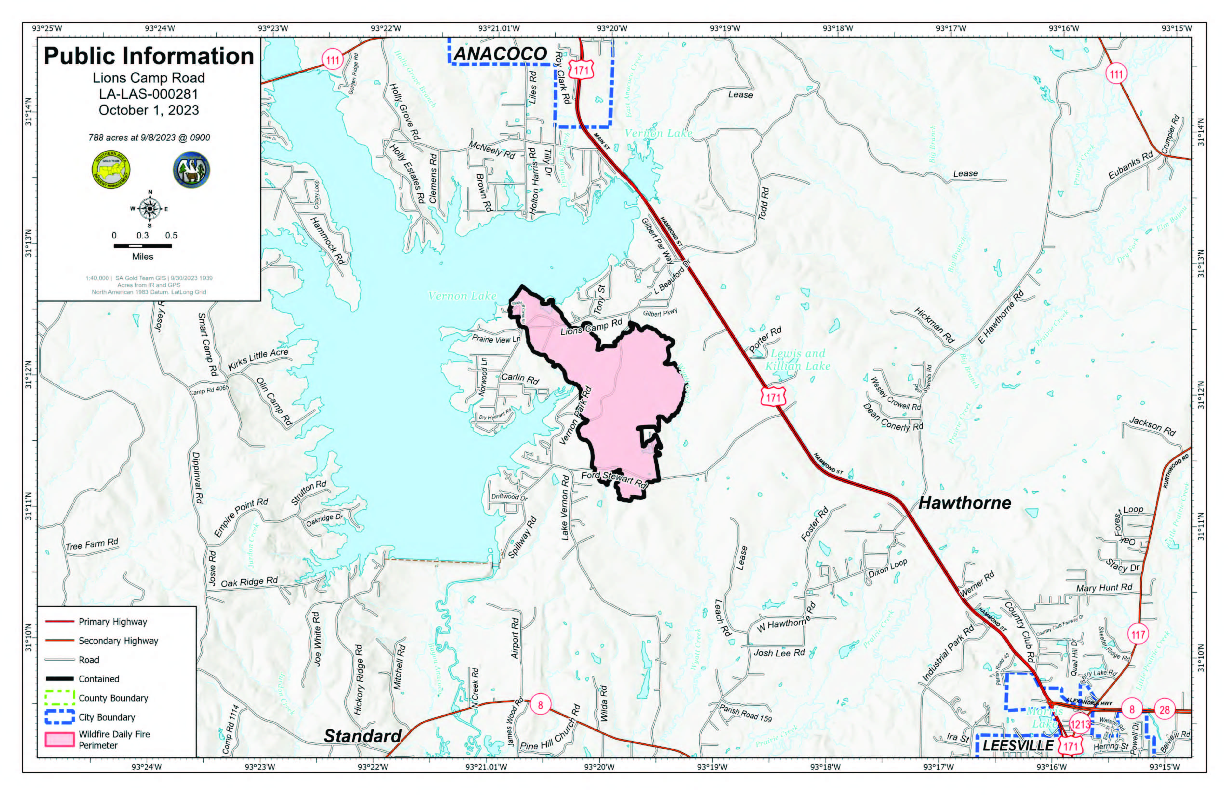
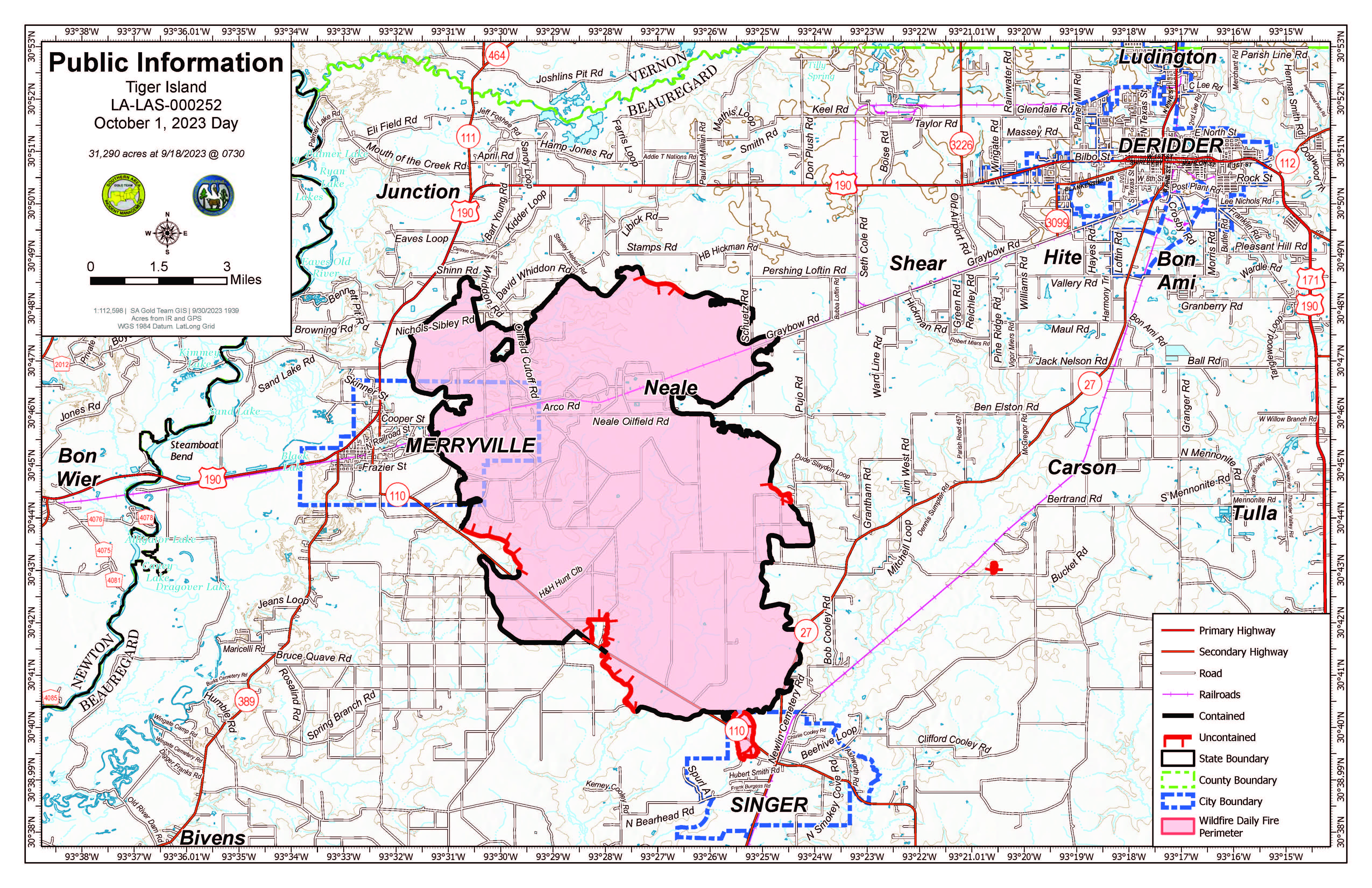
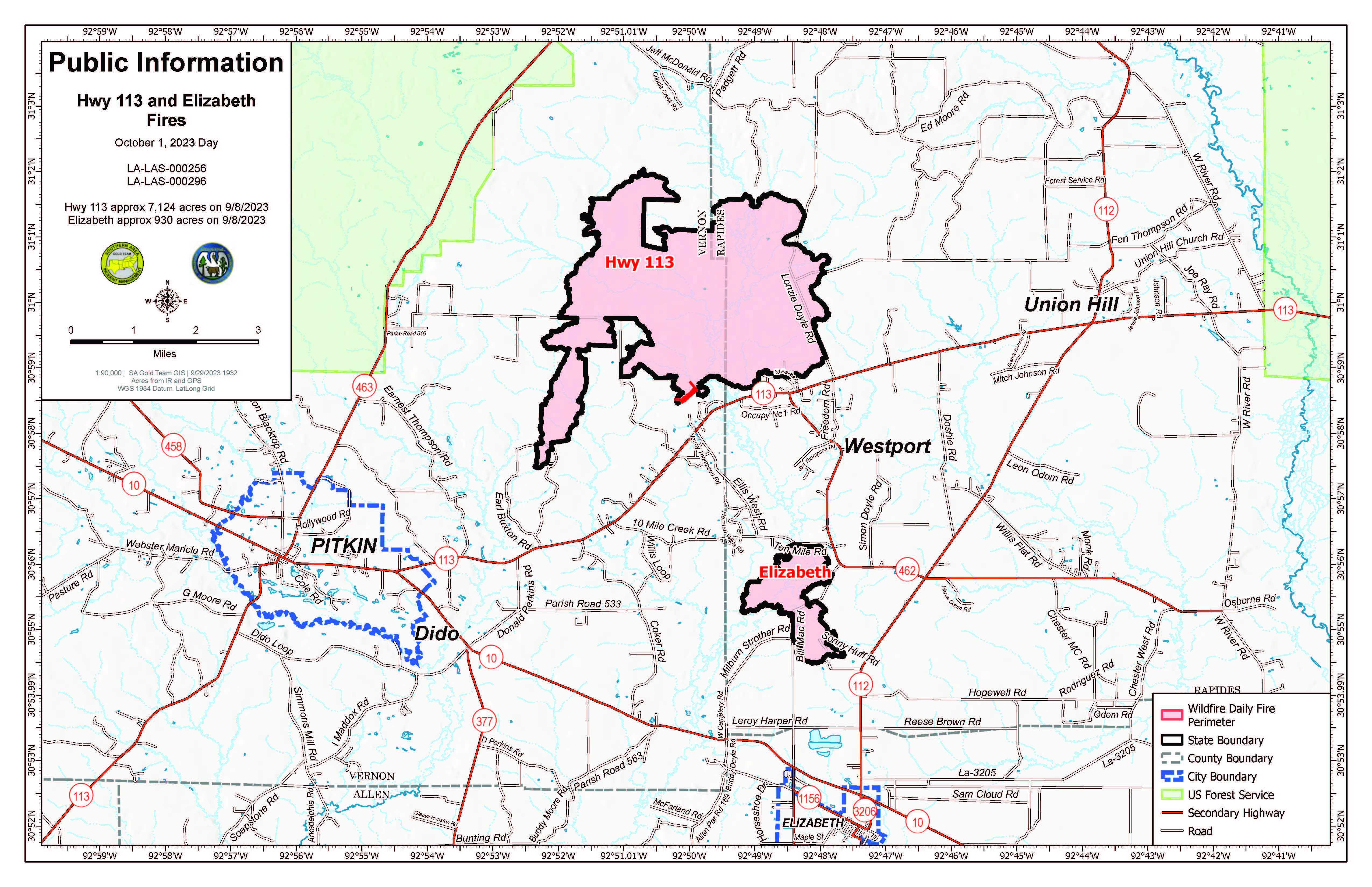
Daily Update Sunday October 1 2023
Related Incident: Tiger Island FireLions Camp Road FireElizabeth Fire
Publication Type: News
![]()
![]() Tiger Island, Hwy 113, Lions Camp Road and Elizabeth Fires
Tiger Island, Hwy 113, Lions Camp Road and Elizabeth Fires
Daily Update – Sunday October 1, 2023
Southern Area Complex Incident Management Gold Team
Hours: 8 a.m. – 8 p.m. Phone: 318-239-9263 Email: 2023.TigerIsland@firenet.gov
Facebook page for all fires: https://www.facebook.com/TigerIslandFire
Louisiana Department of Agriculture and Forestry Modifies Statewide Burn Ban
As of 5 p.m. on September 27, 2023, LDAF modified its burn ban order to allow agricultural burning to resume, including but not limited to prescribed burning except for standing sugarcane. The Louisiana Office of the State Fire Marshal also modified its burn ban order to allow individual parishes to opt out of the statewide burn ban, fire chiefs to resume granting burn permissions, and certain live fire training to resume with its written permission effective as of 5 p.m., September 29, 2023. This order is reevaluated weekly. As parishes opt out of the statewide burn ban, the Louisiana Burn Ban Map will be updated at https://t.ly/CETXf. Visit https://t.ly/Y5b9N for more information.
Fire Highlights
A red flag warning is in effect again today as very hot, dry and windy conditions persist over the fires. On the Tiger Island, Hwy. 113, Elizabeth and Lions Camp Road Fires yesterday, crews continued to patrol containment lines, seek out heat signatures, and mop up hotspots. They also checked containment lines and cleared them of needle cast that could increase reburn potential. On the Hwy. 113 and Elizabeth Fires, firefighters continued to investigate heat within the 10-Mile Creek Drainage. Timber salvage operations are progressing on the Tiger Island and Lions Camp Road Fires.
Today, crews will continue to mop up and patrol containment lines for heat sources that could initiate reburning while keeping the fire within its current perimeter. All resources are available to assist the state with initial attack as needed.
Tiger Island Fire: 31,290 acres, no change | 84% contained| 197 personnel assigned
InciWeb: https://inciweb.nwcg.gov/incident-information/lalas-tiger-island-fire
Hwy. 113 Fire: 7,124 acres, no change | 95% contained | 33 personnel assigned
InciWeb: https://inciweb.nwcg.gov/incident-information/lalas-hwy-113-fire
Lions Camp Road Fire: 785 acres, no change | 95% contained | 4 personnel assigned.
InciWeb: https://inciweb.nwcg.gov/incident-information/lalas-lions-camp-road-fire
Elizabeth Fire: 940 acres, no change | 98% contained | 13 personnel assigned
InciWeb: https://inciweb.nwcg.gov/incident-information/lalas-elizabeth-fire
Equipment
Type 6 engines, dozers, tractor plow units, water tenders, medical squads and ambulances are assigned to the fires. Aerial resources including helicopters and fixed-wing aircraft also are available. Parish authorities and departments, sheriff’s offices, and the Governor’s Office of Homeland Security and Emergency Preparedness are providing additional support.
Weather and Fire Behavior
A red flag warning is in effect again today for the fire area. Relative humidity will be between 20 and 30% with high temperatures in the mid-to-upper 90s. Meanwhile vegetation is extremely dry due to the ongoing exceptional drought. Low relative humidity, combined with high temperatures and wind gusts up to 20 mph today favor the start and rapid spread of any new wildland fires. Initial attack remains a possibility; fire behavior will be very aggressive for crews responding to any new fires. Updates on fire weather conditions are available at https://www.weather.gov/lch.
Air Quality
Smoke may occur in reburn areas. Air quality information is available at https://fire.airnow.gov.
Temporary Flight Restrictions (TFRs)
TFRs remain in place over the Tiger Island Fire (https://tfr.faa.gov/save_pages/detail_3_3911.html) and over the Hwy. 113 and Elizabeth Fires https://tfr.faa.gov/save_pages/detail_3_4065.html). Remember: If you fly, we can’t.
Quarry Fire Daily Update Sep 30
Related Incident: 2023-STF-Quarry Fire
Publication Type: Announcement
Quarry Fire Update
Saturday, September 30, 2023
Stanislaus National Forest PIO Contacts:
Incident Management Team (Type-3) Eugenie Moore - eugenie.moore@usda.gov
steve lyon - slyon@nps.gov
Fire Statistics:
Location: The Quarry Fire is located on the Mi-Wok Ranger District, Stanislaus National Forest, off Forest Road 3N01, east of Bourland Creek and approximately four miles west of the Emigrant Wilderness Border.
Acres Burned Today: 40 Cause: Lightning Injuries: 0
Acres Burned to Date: 5,557 Total Personnel: 138
Background: The Quarry fire was one of many fires ignited by lightning strikes across the forest on September 9, 2023. District fire managers immediately worked to ensure these naturally ignited fires stayed within pre-determined boundaries. Fire personnel with the Stanislaus National Forest are currently managing the Quarry Fire to achieve multiple resource objectives.
Current Activities:
There was very little growth on the fire’s perimeter today, with rain and drizzle falling most of the day. Crews worked on clearing hazard trees near roads and trails and gathered down fuels for pile burning.
Fire professionals are managing fire behavior and intensity to provide for multiple resource benefits including reducing concentrations of all fuels, re-establishing multigenerational timber stands, improving wildlife habitat, promoting plant diversity, and re-introducing fire into fire adapted ecosystems.
Closures:
Soft closures are in effect to provide for the safety of the public utilizing public lands as well as fire personnel working in the area. The soft closures are an encouragement for the public to stay clear of the area, to find alternate routes to their locations and to provide fire personnel the widest berth possible as they go about their mission.
With the public’s cooperation, we will continue to monitor the number and duration of each, recognizing that fire personnel and public safety is the focus.
As of September 28, 2023, the following soft closures are in effect:
3N21 where it meets 3N16 3N34Y 3N16
2N71 where it meets 3N16 3N01L 3N16 at 3N94
3N21 where it meets 3N01 3N01J
3N22 where it meets 3N01 3N01H
Smoke:
Smoke impacts from the Quarry Fire, the prescribed burns of the Experimental Forest, Dry Meadows and Beardsley Burn units on the Summit Ranger District will cause smoke to settle in low lying areas. Check out the fire and smoke map at fire.airnow.gov for more information.
Quarry Fire Daily Update Sep 29
Related Incident: 2023-STF-Quarry Fire
Publication Type: Announcement
Quarry Fire Update
Friday, September 29, 2023
Stanislaus National Forest PIO Contacts:
Incident Management Team (Type-3) Phylis Ashmead, phyllis.ashmead@gmail.com
Eugenie Moore, eugenie.moore@usda.gov
Fire Statistics:
Location: The Quarry Fire is located on the Miwok Ranger District, Stanislaus National Forest, off Forest Road 3N01, east of Bourland Creek and approximately four miles west of the Emigrant Wilderness Border.
Acres Burned Today: 819 Cause: Lightning Injuries: 0
Acres Burned to Date: 5,517 Total Personnel: 114
Background: The Quarry fire was one of many fires ignited by lightning strikes across the forest on September 9, 2023. District fire managers immediately worked to ensure these naturally ignited fires stayed within pre-determined boundaries. Fire personnel with the Stanislaus National Forest are currently managing the Quarry Fire to achieve multiple resource objectives.
These objectives include benefits such as reducing concentrations of dead ground fuels, re-establishing multigenerational timber stands, improving wildlife habitat, promoting vegetation diversity, and re-introducing fire into fire adapted ecosystems.
Current Activities:
Crews completed firing on the eastern flank bringing fire down to Reynolds Creek. Favorable burning conditions produced good consumption of heavy dead and down woody material. UAS (Unmanned Aerial System) conducted reconnaissance for future burning opportunities.
On the western flank of the fire, crews on the ground and crews flying the UAS brought fire down to the 3N27C road, filling in the unburned areas.
Fire professionals are managing fire behavior and intensity to provide for multiple resource benefits including reducing concentrations of all fuels, re-establishing multigenerational timber stands, improving wildlife habitat, promoting plant diversity, and re-introducing fire into fire adapted ecosystems.
Closures:
Soft closures are in effect to provide for the safety of the public utilizing public lands as well as fire personnel working in the area. The soft closures are an encouragement for the public to stay clear of the area, to find alternate routes to their locations and to provide fire personnel the widest berth possible as they go about their mission. With the public’s cooperation, we will continue to monitor the number and duration of each, recognizing that fire personnel and public safety is the focus.
As of September 28, 2023, the following soft closures are in effect:
- 3N21 where it meets 3N16
- 2N71 where it meets 3N16
- 3N21 where it meets 3N01
- 3N22 where it meets 3N01
- 3N34Y
- 3N01L
- 3N01J
- 3N01H
- 3N16
- 3N01 between Bourland Creek to Reynolds Creek
- 3N01 at 3N16
- 3N16 at 3N94
- 3N01 at 2N05X
Smoke:
Smoke impacts from the Quarry Fire, the prescribed burns of the Experimental Forest, Dry Meadows and Beardsley Burn units on the Summit Ranger District will cause smoke to settle in low lying areas. Check out the fire and smoke map at fire.airnow.gov for more information.
Quarry Fire Daily Update Sep 28
Related Incident: 2023-STF-Quarry Fire
Publication Type: Announcement
Quarry Fire Update
Thursday, September 28, 2023
Stanislaus National Forest PIO Contacts:
Incident Management Team (Type-3) Phylis Ashmead, phyllis.ashmead@gmail.com
Eugenie Moore, ugenie.moore@usda.gov
Fire Statistics:
Location: The Quarry Fire is located on the Miwok Ranger District, Stanislaus National Forest, off Forest Road 3N01, east of Bourland Creek and approximately four miles west of the Emigrant Wilderness Border.
Acres Burned Today: 1,369 Cause: Lightning Injuries: 0
Acres Burned to Date: 4,737 Total Personnel: 159
Background: The Quarry fire was one of many fires ignited by lightning strikes across the forest on September 9, 2023. District fire managers immediately worked to ensure these naturally ignited fires stayed within pre-determined boundaries. Fire personnel with the Stanislaus National Forest are currently managing the Quarry Fire to achieve multiple resource objectives.
These objectives include benefits such as reducing concentrations of dead ground fuels, re-establishing multigenerational timber stands, improving wildlife habitat, promoting vegetation diversity, and re-introducing fire into fire adapted ecosystems.
Current Activities:
Both UAS (Unmanned Aerial System) crews worked together along the eastern flank bringing fire toward the Emigrant Wilderness boundary west of Cherry Creek and Reynolds Creek to the east.
Crews brought fire down the western flank towards FS Rd 3N16, filling in unburned areas.
Fire managers are strategically using this lightning caused fire to benefit the overall health of this fire-adapted forest. Wildfires are a natural part of the Stanislaus National Forest ecosystem. The Quarry Fire will improve the landscape in the long term as favorable burning conditions are resulting in a mosaic of low intensity burn effects.
Closures:
Soft closures are in effect to provide for the safety of the public utilizing public lands as well as fire personnel working in the area. The soft closures are an encouragement for the public to stay clear of the area, to find alternate routes to their locations and to provide fire personnel the widest berth possible as they go about their mission. With the public’s cooperation, we will continue to monitor the number and duration of each, recognizing that fire personnel and public safety is the focus.
As of September 28, 2023, the following soft closures are in effect:
- 3N21 where it meets 3N16
- 2N71 where it meets 3N16
- 3N21 where it meets 3N01
- 3N22 where it meets 3N01
- 3N34Y
- 3N01L
- 3N01J
- 3N01H
- 3N16
- 3N01 Between Bourland Creek to Reynolds Creek
- 3N01 at 3N16
- 3N16 at 3N94
- 3N01 at 2N05X
Smoke:
Smoke impacts from the Quarry Fire, the prescribed burns of the Experimental Forest, Dry Meadows and Beardsley Burn units on the Summit Ranger District will cause smoke to settle in low lying areas. Check out the fire and smoke map at fire.airnow.gov for more information.