
Morning Update Monday October 2 2023
Related Incident: Bedrock FireLookout FirePetes Lake Fire2023 Horse Creek Fire
Publication Type: News
Lookout, Bedrock, Petes Lake, Horse Creek and Pothole Fires
Monday, October 2, 2023 - Morning Update – 9:00 a.m.
Lookout Fire - Size: 25,751 acres | Start Date: August 5 | Cause: Lightning | Containment: 50%
Bedrock Fire - Size: 31,590 acres | Start Date: July 22 l Cause: Under Investigation l Containment: 98%
Petes Lake Fire - Size: 3,254 acres | Start Date: August 25 | Cause: Lightning | Completion: 80%
Horse Creek Fire - Size: 763 acres | Start Date: August 24 | Cause: Lightning | Containment: 100%
Pothole Fire - Size: 109 acres | Start Date: August 25 | Cause: Lightning | Containment: 100%
Total Assigned Personnel: 419| 13 engines | 8 crews | 2 dozers | 3 water tenders | 2 masticators | 2 helicopters
(Walterville, Ore.) – Reconnaissance flights on Sunday confirmed that, while scattered hot spots continue to smolder, the fires remain within established perimeters. Where direct containment lines were not constructed, due to unacceptable risk to firefighter safety from rugged terrain or danger trees/snags, indirect contingency lines and other protections for values at risk are in place. Though fires are controlled, important work remains. Crews continue to repair damage caused by suppression activities, as progress is made fire managers are releasing resources. By the end of the day today, more than one-quarter that started the weekend will be returning to their home units.
Suppression Repair: This critical work has been well underway on the fires. Crews are engaged in activities that will minimize soil erosion and other impacts, aiding ecosystem recovery and reducing the risk of future fires. Work also includes chipping and removing large amounts of woody debris, drainage work and fire line naturalization. These repairs are an integral aspect of restoration of the affected forest. As projects are completed, fire managers will continue to reduce resources.
Burned Area Emergency Rehabilitation (BAER): An Emergency Response Team of resource specialists continue field surveys and assessments for the burned areas of the Lookout, Pothole and Horse Creek Fires. For more information regarding this BAER team’s assessment, follow the Willamette National Forest Facebook.
Weather: Scattered rainfall is in the forecast for early Monday morning and, in the afternoon, wetting rain is expected across the region with a higher chance of precipitation over the Lookout Fire footprint. After Tuesday morning’s chance of drizzle passes, a steady warming trend is forecast for the rest of the week.
Forest Closures: Established closures on the Willamette National Forest remain in place around fire-impacted areas, including the Lookout and Bedrock Fires. The public is urged to “Know Before You Go” by visiting the Willamette National Forest official webpage. For specific hunting-related questions, contact Oregon Department of Fish and Wildlife at (503) 947-6000.
Safety: The public is asked to exercise caution along roadways around the fire. Drivers should be extra vigilant along Forest Road 15 between Highway 126 and Highway 20 where crews and heavy equipment are traveling and engaging in suppression repair work.
Daily Update Monday October 2 2023
Related Incident: Tiger Island FireElizabeth FireLions Camp Road Fire
Publication Type: News
Tiger Island, Hwy 113, Lions Camp Road and Elizabeth Fires
Daily Update – Monday October 2, 2023
Southern Area Complex Incident Management Gold Team
Hours: 8 a.m. – 8 p.m. Phone: 318-239-9263 Email: 2023.TigerIsland@firenet.gov
Facebook page for all fires: https://www.facebook.com/TigerIslandFire
Louisiana Department of Agriculture and Forestry Modifies Statewide Burn Ban
As of 5 p.m. on September 27, 2023, LDAF modified its burn ban order to allow agricultural burning to resume, including but not limited to prescribed burning except for standing sugarcane. The Louisiana Office of the State Fire Marshal also modified its burn ban order to allow individual parishes to opt out of the statewide burn ban, fire chiefs to resume granting burn permissions, and certain live fire training to resume with its written permission effective as of 5 p.m., September 29, 2023. This order is reevaluated weekly. As parishes opt out of the statewide burn ban, the Louisiana Burn Ban Map will be updated at https://t.ly/CETXf. Visit https://t.ly/Y5b9N for more information.
Fire Highlights
A red flag warning is in effect for the third day in a row as very dry, hot and windy conditions continue over the fires.
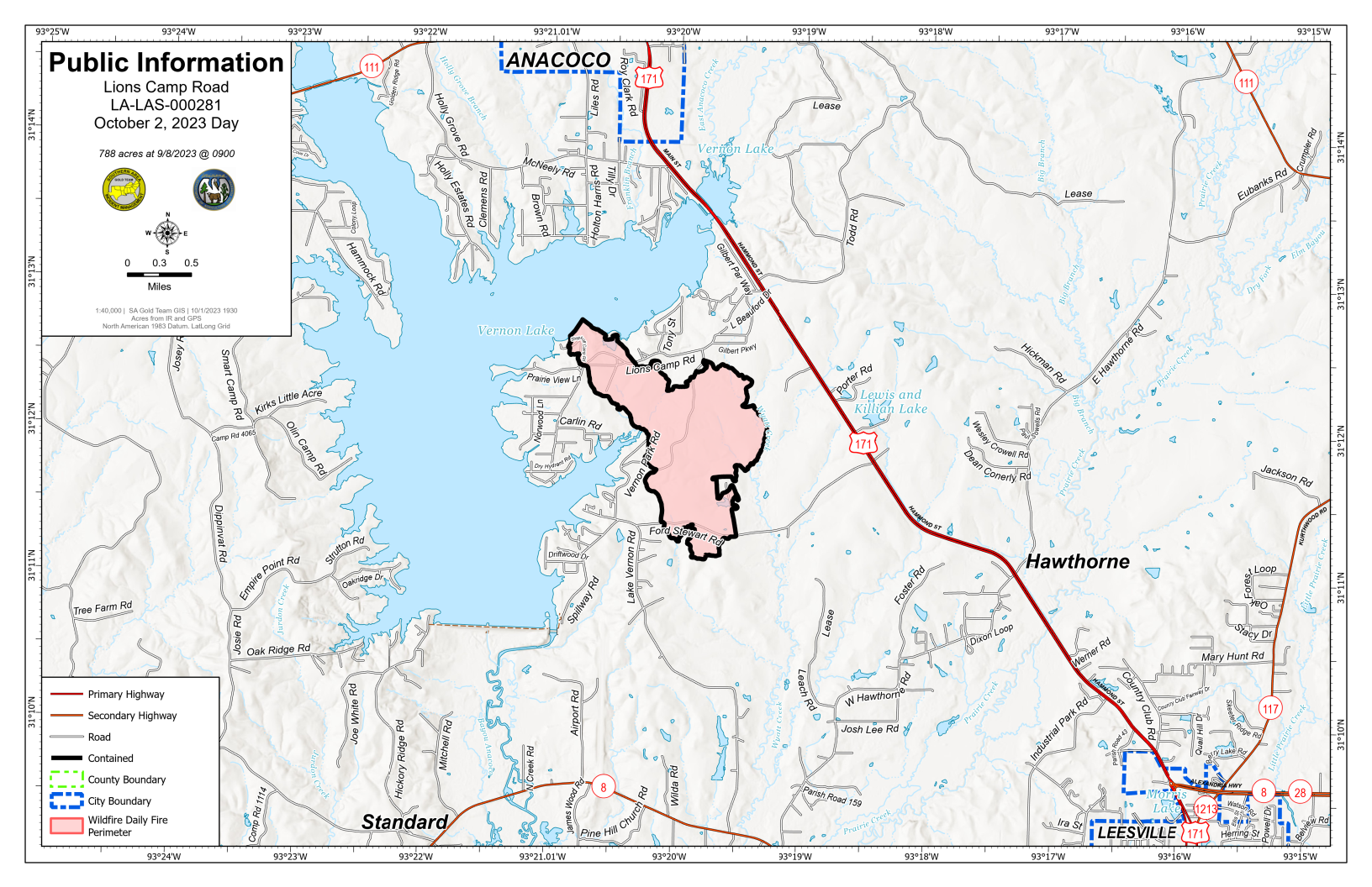
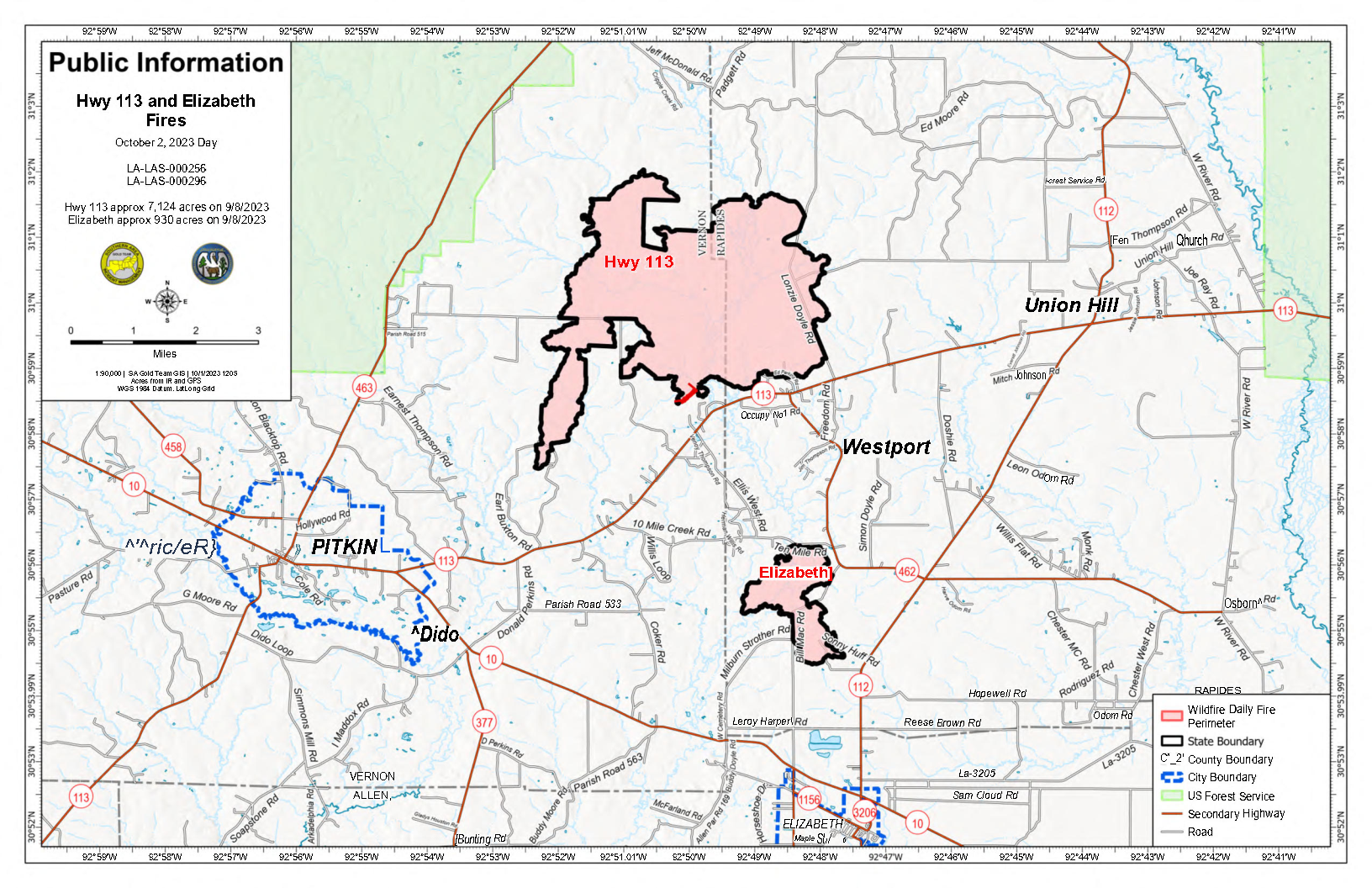
Fire behavior inside the fires’ footprints were minimal yesterday. On the Tiger Island, Hwy. 113, Elizabeth and Lions Camp Road Fires, crews patrolled containment lines, sought out heat signatures, and mopped up hotspots. They also cleared containment lines of needle cast that have the potential to reburn. Specific to the Hwy. 113 and Elizabeth Fires, firefighters continued to investigate heat within the 10-Mile Creek Drainage. Timber salvage operations continue making progress on the Tiger Island and Lions Camp Road Fires.
Crews will patrol containment lines for heat sources, mop up and patrol containment lines again today. All resources are available to assist the state of Louisiana with initial attack as needed.
Tiger Island Fire: 31,290 acres, no change | 84% contained| 194 personnel assigned
InciWeb: https://inciweb.nwcg.gov/incident-information/lalas-tiger-island-fire
Hwy. 113 Fire: 7,124 acres, no change | 95% contained | 33 personnel assigned
InciWeb: https://inciweb.nwcg.gov/incident-information/lalas-hwy-113-fire
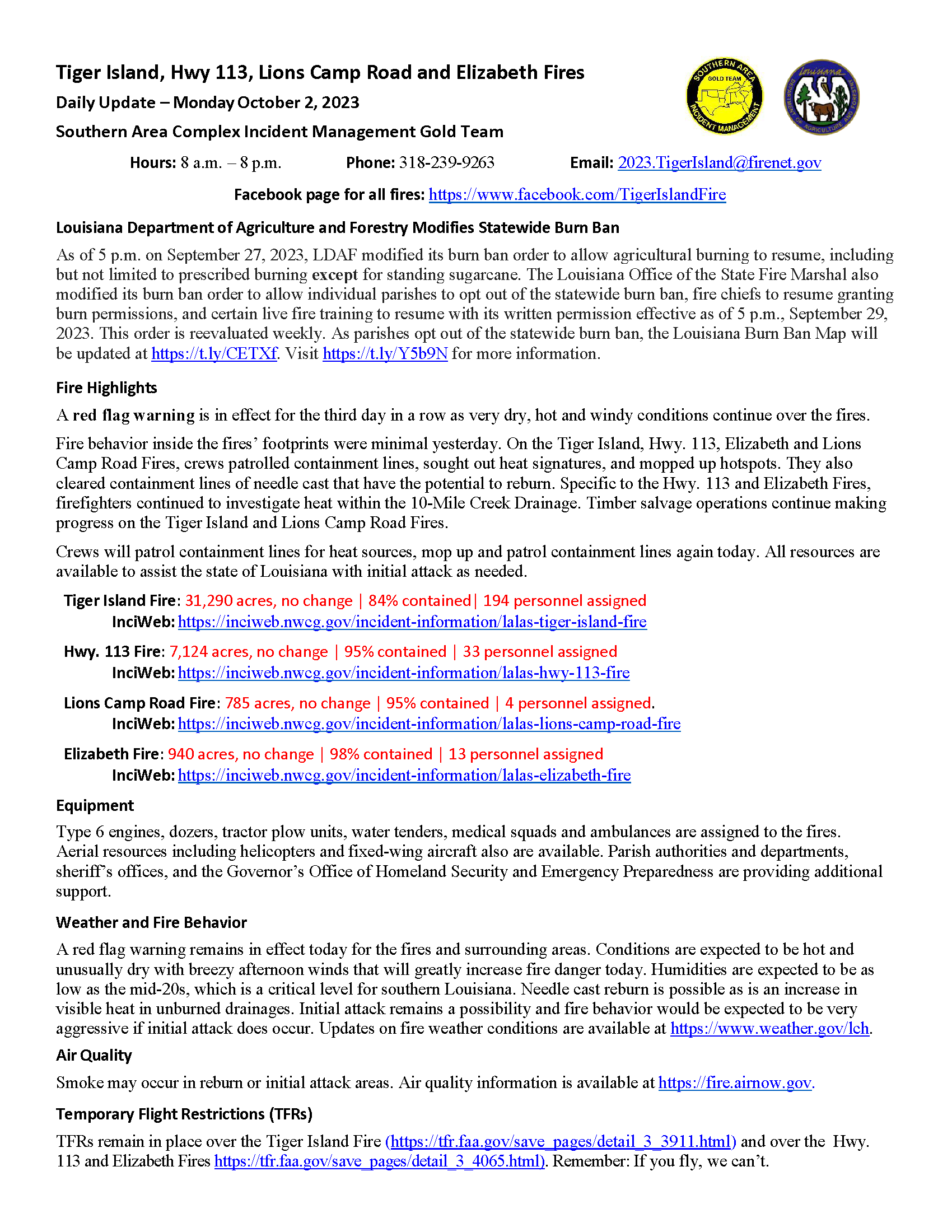
Lions Camp Road Fire: 785 acres, no change | 95% contained | 4 personnel assigned.
InciWeb: https://inciweb.nwcg.gov/incident-information/lalas-lions-camp-road-fire
Elizabeth Fire: 940 acres, no change | 98% contained | 13 personnel assigned
InciWeb: https://inciweb.nwcg.gov/incident-information/lalas-elizabeth-fire
Equipment
Type 6 engines, dozers, tractor plow units, water tenders, medical squads and ambulances are assigned to the fires. Aerial resources including helicopters and fixed-wing aircraft also are available. Parish authorities and departments, sheriff’s offices, and the Governor’s Office of Homeland Security and Emergency Preparedness are providing additional support.
Weather and Fire Behavior
A red flag warning remains in effect today for the fires and surrounding areas. Conditions are expected to be hot and unusually dry with breezy afternoon winds that will greatly increase fire danger today. Humidities are expected to be as low as the mid-20s, which is a critical level for southern Louisiana. Needle cast reburn is possible as is an increase in visible heat in unburned drainages. Initial attack remains a possibility and fire behavior would be expected to be very aggressive if initial attack does occur. Updates on fire weather conditions are available at https://www.weather.gov/lch.
Air Quality
Smoke may occur in reburn or initial attack areas. Air quality information is available at https://fire.airnow.gov.
Temporary Flight Restrictions (TFRs)
TFRs remain in place over the Tiger Island Fire (https://tfr.faa.gov/save_pages/detail_3_3911.html) and over the Hwy. 113 and Elizabeth Fires https://tfr.faa.gov/save_pages/detail_3_4065.html). Remember: If you fly, we can’t.
2023 SRF Lightning Complex Update October 2 2023
Related Incident: 2023 SRF Lightning Complex and Redwood Lightning Complex
Publication Type: News
Fire Update
2023 SRF Lightning Complex
Monday, October 2, 2023 – 8:00 A.M.
California Interagency Incident Management Team 16
John Goss, Incident Commander
Information Phone: 530-536-0767
Email: 2023.lightningcomplex@firenet.gov
Information Staffing Hours: 8 am to 8 pm
This update covers 6 of the 15 fires being managed as part of the SRF Lightning Complex. The Copper Fire (2184 acres) was absorbed by the Blue Creek #2 Fire. On September 22, 2023, the Bluff #1 Fire (4270 acres) and Blue Creek #2 Fire (9751 acres) were absorbed by the Mosquito Fire. The combination of Blue Creek #2 Fire, Bluff #1 Fire, and Mosquito Fire is now referred to as the Mosquito Fire. On September 30, 2023 we incorporated the management of the Hancock fire (1,728 acres, 100% contained). The remaining 6 fires (Big Foot, Blue Creek, Creek, Flat, Iron, and Merrill) totaling 34 acres, are contained and in patrol status. They are checked daily, and their size and containment remain unchanged.
Current Situation:
The 15 fires on this incident total 49,428 acres and overall containment is 20%. In total, 585 personnel are assigned to the incident. A warming and drying trend is occurring across the Complex. Firefighters continue to diligently respond to and address additional smokes as they present themselves. This written incident update will be distributed every other day. If fire conditions necessitate this update will return to being distributed as often as necessary.
Crews continue to actively assess the conditions of the Pearch and Mosquito Fires. Prioritizing the safety of firefighters and the public is paramount, given that recent rainfall has heightened the risk of fire-weakened trees falling due to the saturation of soil. Continuous monitoring efforts have been extended to cover the remote Marlow Fire and the north side of the Mosquito Fire. Progress resumed on the mowing and mastication work along the Bluff Creek Road and Slate Creek Road. This work is intended to establish a fuel break for potential future needs. On the Pearch Fire, the process of backhauling pumps and hoses from locations where they are no longer needed is ongoing. Suppression repair has begun where appropriate.
Firefighters are closely monitoring the Highway 96 corridor and Salmon River Road for any signs of falling rocks, debris, or fire activity. Both CalTrans and Siskiyou County crews remain on standby to clear roadways if necessary. Special attention is being given to assessing and mitigating the risk posed by fire-weakened trees with root systems affected by wet soils before reengaging on fire control lines. Fire activity is expected to increase throughout the week, several areas still contain heat sources and large diameter trees that continue to burn and generate smoke. Therefore, smoke may remain visible across all areas affected by the fires as warmer and dryer conditions return in the coming days.
Pearch Fire (12,126 acres, 31% contained) – Firefighters are holding and improving fire lines along the Highway 96 corridor and Butler Flat. Mop up work continues in and around structures. Continued efforts will focus on packing up and backhauling pumps, hose, and other equipment.
Mosquito Fire (33,445 acres, 10% contained) – Crews and equipment have returned to the Bluff Creek Road and Slate Creek Road to resume mastication work, aimed at creating a fuel break along these routes. Several days of mastication work are anticipated to prepare these roads effectively. Fire managers will maintain vigilance regarding fire activity on the north side, which remains in a remote location. On the east and west sides of the fire, crews continue to secure control lines, mop up and address hot spots near the line.
Marlow Fire (1,988 acres, 0% contained) – Minimal activity is reported on the Marlow Fire, which is in a remote area. The fire is contained by indirect control lines to the east and south, as well as prior fire footprints where fuels are less dense. No values or structures are currently threatened by the Marlow Fire.
Monument (2 acres, 100% contained), Let er-Buck (96 acres, 100% contained) and Hancock (1,729 acres, 100% contained) Fires – A confinement strategy has been employed for these three fires due to the limited values at risk and the challenging, remote, and steep terrain, which presents safety concerns for firefighters. Natural fire barriers such as rock outcroppings and old fire footprints with sparse fuels are being used to contain fire growth until the arrival of season-ending precipitation. Regular monitoring ensures that both fires remain within an acceptable perimeter, all are now considered 100% contained.
Weather: A weak system will pass to the north of the fire Monday through Tuesday morning bringing increasing clouds, but no precipitation is expected. Temperatures will continue to warm with highs reaching the upper 70s to mid-80s in the valleys and upper 50s to upper 60s on the mid-slopes and ridges. Gusty northerly winds are expected on Tuesday with speeds up to 25 mph on the ridges. Afternoon humidity values will trend downward through this period with valleys seeing readings generally in the 20s with lower 30s to lower 40s on the mid-slopes and ridges. Mid-slopes and ridges will see only moderate overnight recoveries with values holding in the upper 30s to mid-40s.
Please stay informed and exercise caution in the affected areas and be aware that warmer and drier conditions may lead to ongoing fire-related challenges.
Evacuation Information
Siskiyou County Office of Emergency Services: https://www.co.siskiyou.ca.us/emergencyservices
Closures
Six Rivers National Forest: Area and campground closures are in effect on portions of Six Rivers National Forest. They can be found at: https://www.fs.usda.gov/detail/srnf/notices/?cid=FSEPRD1096395.
Additional Fire Information
Facebook: https://www.facebook.com/2023SRFRedwoodLightning
More Fire Information Links: www.linktr.ee/srffirepio
For Air Quality Information: www.airnow.gov
NOTE: For information about the Elliot Fire which is part of the
Happy Camp Complex, please visit https://linktr.ee/happycampcomplex2023 .
Ridge Creek Fire Closure extension
Related Incident:
Publication Type: Closures
The existing road, trail, and area closure for the Ridge Creek Fire has been extended through October 6th. See closure document for details and map.
Quarry Fire Daily Update Oct 2
Related Incident: 2023-STF-Quarry Fire
Publication Type: Announcement
Quarry Fire Update
Sunday, October 1st, 2023
Stanislaus National Forest
Incident Management Team (Type-3)
PIO Contacts: Eugenie Moore - eugenie.moore@usda.gov
steve lyon - slyon@nps.gov
Fire Statistics:
Location: The Quarry Fire is located on the Stanislaus National Forest, Mi-Wok Ranger District, off Forest Road 3N01, east of Bourland Creek and adjacent to the Emigrant Wilderness Border.
Acres Burned Today: 40
Acres Burned to Date: 5,557
Cause: Lightning
Containment: 13.5%
Total Personnel: 138
Injuries: 0
Background: The Quarry fire was one of many fires ignited by lightning strikes across the forest on September 9, 2023. District fire managers immediately worked to ensure these naturally ignited fires stayed within pre-determined boundaries. Fire personnel with the Stanislaus National Forest are currently managing the Quarry Fire to achieve multiple resource objectives.
Current Activities: Crews cleared roads and removed hazard trees, reducing the build-up of dead wood on the forest floor, and consolidating the wood into piles. Piled wood consumes faster, reducing lingering smoke impacts.
Fire professionals are managing fire behavior and intensity to provide for multiple resource benefits including reducing concentrations of all fuels, re-establishing multigenerational timber stands, improving wildlife habitat, promoting plant diversity, and re-introducing fire into fire adapted ecosystems.
Closures: Soft closures are in effect to provide for the safety of the public utilizing public lands as well as fire personnel working in the area. The soft closures are an encouragement for the public to stay clear of the area, to find alternate routes to their locations and to provide fire personnel the widest berth possible as they go about their mission.
With the public’s cooperation, we will continue to monitor the number and duration of each, recognizing that fire personnel and public safety is the focus.
As of October 1, 2023, the following soft closures are in effect:
3N21 where it meets 3N16
2N71 where it meets 3N16
3N21 where it meets 3N01
3N22 where it meets 3N01
3N34Y
3N01L
3N01J
3N01H
3N16
3N16 at 3N94
Smoke: Smoke impacts from the Quarry Fire, the prescribed burns of the Experimental Forest, Dry Meadows and Beardsley Burn units on the Summit Ranger District will cause smoke to settle in low lying areas. Check out the fire and smoke map at fire.airnow.gov for more information.
More Information:
INCIWEB - Quarry Fire Info - https://inciweb.wildfire.gov/incident-information/castf-2023stfquarry-fire
Stanislaus National Forest – Official Website - https://www.fs.usda.gov/stanislaus
Umpqua Fires October 2 2023
Related Incident: 2023 Chilcoot Fire UNFGrizzly Fire
Publication Type: News
Crews are now re-engaged after the heavy rains, and the drying trend throughout the week will help suppression repair efforts. A UAS (unmanned aerial system) module is being utilized to perform reconnaissance to better assist firefighters locate hotspots along the fire perimeter.
Dinner: Crews continue to backhaul slash off of the fireline. Suppression repair is estimated to be complete in 2 operational shifts. Containment– 95%
Grizzly: Backhaul is complete and crews continue to patrol the fire. Containment – 0%
Brice Creek: Suppression repair is complete to forest standards and the fire remains in patrol status. Containment – 95%
Chilcoot: Dozer lines are being repaired and roads will be graded. Containment – 82%
Ridge: Suppression repair continues and is expected to be complete in 3 operational shifts. Containment – 95%
A temporary flight restriction has been put in place over the fire area to provide a safe environment for air resources and firefighters who are engaged in mop up and suppression actions on the ground. FAA Temporary Flight Restrictions -- Graphics
There is a forest closure for portions of the Umpqua National Forest in response to fire activity in the area to protect public and wildland firefighter safety.
Fire Information: (541) 900-5862, 8:00 AM – 5:00 PM Email: 2023.chilcoot@firenet.gov
Facebook:
https://www.facebook.com/chilcootridgefires2023
https://www.facebook.com/bricecreekdinnergrizzlyfires2023/
Inciweb:
Grizzly Fire Inciweb: https://inciweb.wildfire.gov/incident-information/orupf-grizzly-fire
Chilcoot Fire Inciweb: https://inciweb.wildfire.gov/incident-information/orupf-2023-chilcoot-fire-unfP
Anvil and Flat Fires Update October 2 2023
Related Incident: Anvil FireFlat Fire
Publication Type: News
Highlight: There will be a public meeting for the Anvil and Flat fires on Tuesday, October 3 at 7:00 PM at the Sixes Grange. The meeting will also be streamed live at facebook.com/flatfireoregon2023
Anvil Fire
Size: 22,173 acres Start Date: August 25, 2023 Location: 8 miles east of Port Orford, OR
Containment: 43% Total personnel: 1,207 Resources: 32 crews, 7 helicopters, 36 engines
Crews made significant progress yesterday constructing containment lines on the north and west side of the fire. Suppression repair work began along the Sixes River Road and a structure group has been cleaning up around residences along the Elk River. On the southeast perimeter of the fire, firefighters continue work to establish contingency lines south towards Milbury Mountain.
Today, crews will work on completing containment lines on the west side of the fire. Work is ongoing to identify and begin construction of secondary and contingency lines for uncontained areas of the fire that are burning in inaccessible and problematic terrain. Large timber and heavier fuels still have below average moisture levels and will continue to hold heat. Burning will become more active as temperatures rise and humidities drop. Additional smoke will be visible as warmer temperatures and strong ridge-top winds contribute to an increase in fire behavior over the next few days.
Evacuations: Curry County Sheriff’s Office has identified evacuation zones near the Anvil Fire: Zones 1, 2, and 4 are in Level 2 “Set” status. Zone 3 is in Level 1 “Ready” status. Conditions may change quickly. Monitor for updates in evacuation levels. View the interactive evacuation map at https://bit.ly/AnvilEvacs. Sign up for Curry Co. emergency alerts at https://bit.ly/CurryCoEM.
Flat Fire
Size: 34,242 acres Start Date: July 15, 2023 Location: 2 miles southeast of Agness, OR Containment: 88% Total personnel: 48 Resources: 3 engines
Containment has been increased to 88% as crews secure line along the east side of the Flat Fire. Excavators have arrived to assist with the repair of suppression lines on the northern perimeter of the fire. Crews are working to mitigate hazard trees and repair roads. Helicopter operations will begin to drop straw bales within the Flat Fire for erosion control.
Emergency Fire Area and Road Closures Still in Effect: Forest closures remain in place in both fire areas. Recent precipitation across the forest allowed for the lifting of Public Use Restrictions, which allows campfires on areas of the forest that are not currently under a closure order. Lifting Public Use Restrictions for campfires does not rescind closure orders. Forest staff are working closely with fire managers daily to re-evaluate closures and look for opportunities to reopen them as soon as safely possible for both firefighters and the public. For current closure information and maps, please visit: https://bit.ly/RRSNFAlerts or https://inciweb.wildfire.gov/incident-closures/orrsf-anvil-fire.
Fire Restrictions: The Rogue River-Siskiyou National Forest lifted all Public Use Restrictions on Forest Service lands and moved to “moderate” fire danger. The Industrial Fire Precaution Level was reduced to Level 1. Public Use Restrictions on the Wild Section of the Rogue River are at Stage 1- campfires must be in a fire pan below the high-water mark.
Weather: There is a slight chance for a trace of rain this afternoon as a front passes to the north. Temperatures will warm through the rest of the week.
Smoke: Smoke may be visible at times. For current smoke and air quality updates visit, https://bit.ly/SWORsmoke . Please drive slowly and with headlights on through any fire area.
Roads: Visit www.tripcheck.com or call 511 for current road closures. Do not use forest roads for alternate routes.
Contact Fire Information: (541) 216-4579 or (541) 237-6369
Email: 2023.anvil@firenet.gov
Facebook: facebook.com/flatfireoregon2023
X/Twitter: twitter.com/RRSNF
Inciweb Anvil Fire: bit.ly/AnvilFireOR
Inciweb Flat Fire: bit.ly/FlatFireOR
Informacin actual para los incendios Anvil y Flat 2 de octubre 2023
Related Incident: Anvil FireFlat Fire
Publication Type: News
Puntos importantes: Se estará llevando a cabo una reunión para la comunidad acerca del Incendio Anvil y Flat, el martes, 3 de octubre a las 7:00 pm en Sixes Grange. Se estará transmitiendo en vivo: facebook.com/flatfireoregon2023
Incendio Anvil
Área: 22,173 acres Fecha de inicio: 25 de agosto, 2023 Localizado: 8 millas al Este de Port Orford, OR
Contención: 43% Personal: 1,207 Recursos: 32 escuadrillas de bomberos, 7 helicópteros,36 camiones de bomberos
El día de ayer, los bomberos hicieron un progreso significativo construyendo líneas de contención sobre los lados Norte y Oeste del incendio. Se iniciaron los trabajos de reparación a lo largo de Sixes River Road y un grupo para la infraestructura se ha dedicado a la tarea de limpieza alrededor de las residencias en Elk River. Sobre el perímetro Sureste del Incendio, las escuadrillas de bomberos continúan trabajando arduamente en el establecimiento de las líneas de contingencia al Sur y hacia Milbury Mountain. El día de hoy, los bomberos completaran las líneas de contención sobre el lado Oeste. Se prosigue con la identificación de áreas apropiadas para la construcción de líneas secundarias y de contingencia para las áreas en donde no se ha logrado contener el fuego y localizadas en zonas inaccesibles sobre terrenos difíciles. Arboles de gran tamaño y el resto de material de combustión pesado, aun presenta niveles de humedad por debajo del promedio y continuara manteniendo calor interno. El fuego pasara a ser mas activo en cuanto las temperaturas se incrementen y se dé una disminución en el porcentaje de humedad. Se podrá observar más humo, clima más caluroso y vientos fuertes en los próximos días sobre las partes más elevadas.
Evacuaciones: La Oficina del Alguacil para el Condado de curry, creo zonas de evacuación cerca del Incendio Anvil; Zonas 1, 2 y 4 se encuentran en un Nivel 2 “LISTOS”, la Zona 3 se encuentra en un Nivel de evacuación 1 “PREPARESE”. Las condiciones climáticas podrían cambiar rápidamente. Por favor, este atento a la información actualizada. Para revisar un mapa interactivo de evacuación, visite: https://bit.ly/AnvilEvacs. Puede registrarse en el sistema de Alertas de emergencias para el condado: https://bit.ly/CurryCoEM
Incendio Flat
Área: 34,242 acres Inicio:15 de agosto, 2023 Localizado: 2 millas Sureste de Agness, OR
Contención: 88% Personal: 48 Recursos: 3 camiones de bomberos
Se logro una contención en el incendio de un 88% mientras los bomberos aseguraron las líneas que se extienden a lo largo del lado Este en el incendio Flat. Arribaron las excavadoras al área con el objetivo de apoyar en la reparación de líneas de supresión en el perímetro Norte. Las escuadrillas de bomberos están trabajando en la eliminación de arboles peligrosos y en la reparación de caminos. Se iniciarán las operaciones con helicópteros los cuales derramarán pacas de paja dentro del incendio Flat para controlar el efecto de la erosión sobre el terreno.
Las áreas para Emergencia de Incendio y las Ordenes de Cierre de Carreteras aún se encuentran en efecto: Permanece en pie la Orden de Cierre para los incendios Anvil y Flat. La reciente precipitación a través del bosque ha permitido levantar las Restricciones de Uso Público, permitiendo el uso de fogatas en áreas en donde el bosque no se encuentra bajo Ordenes de Cierre. Tenga en cuenta que esta Orden referida a fogatas, no elimina la Orden de Cierre de caminos. El personal forestal se encuentra trabajando de manera cercana con los manejadores del incendio en la evaluación de medidas de cierre y buscando el momento oportuno para levantarlas tan pronto como sea posible para los bomberos y para el público en general. Puede encontrar mapas e información más detallada en: https://bit.ly/RRSNFAlerts o https://inciweb.wildfire.gov/incident-closures/orrsf-anvil-fire
Restricciones: El Bosque Nacional de Rogue River Siskiyou, levanto todas las Restricciones en las tierras del bosque para uso del público, moviendo el Nivel de Peligro de Incendio a “Moderado” y reduciendo el Nivel de Precaución de Incendios a Nivel 1. Restricciones para el Publico en la sección silvestre de Rogue River, se encuentran en una Fase 1 – el cual se refiere a uso de fogatas en un sartén para fuego y a una altura más baja del nivel del agua.
Condiciones climáticas: Existe una ligera posibilidad de lluvias en horas de la tarde al darse paso el frente pasando hacia el Norte. Las temperaturas se incrementarán a lo largo de la semana.
Condiciones del humo: Se podrá ver la presencia del humo de vez en cuando durante el día. Para información actualizada en cuanto a la presencia del humo y la calidad del aire, visite: https://bit.ly/SWORsmoke. Por favor conduzca despacio y con las luces encendidas a través de cualquier área de incendio.
Carreteras: Visite www.tripcheck.com o llame 511 para información al día acerca de cierres de carreteras. Por favor no utilice las carreteras forestales como una ruta alternativa.
Líneas Informativas: (541) 216-4579 o (541) 237-6369
Email: 2023.anvil@firenet.gov
Facebook: facebook.com/flatfireoregon2023
X/Twitter: twitter.com/RRSNF
Inciweb Anvil Fire: bit.ly/AnvilFireOR
Inciweb Flat Fire: bit.ly/FlatFireOR
Forest Service News Release Sep 15
Related Incident: 2023-STF-Quarry Fire
Publication Type: News
Multiple Lightning Caused Fires Being Managed as the Quarry Fire
Forest Service News Release
Benjamin Cossel, Public Affairs Officer, Stanislaus National Forest
W: 209.288.6261 | C: 209.916.5919 | Benjamin.cossel@usda.gov
SONORA, California Sept 15, 2023 – Following a tumultuous series of weekend storms resulting in more than 38 ignitions on the Forest, fire personnel with the Stanislaus National Forest are currently managing the Quarry Fire to achieve multiple resource objectives. The Quarry Fire is located off Forest Road 3N01, east of Bourland Creek and approximately four miles east of the Emigrant Wilderness Border..
Of the other fires across the forest, three (Pilot, Hamilton, and Bar) are out, 14 fires are listed as contained, 15 in control status, eight in patrol status and two (Dome and Sheering) on the Summit/Mi-Wok district are currently staffed.
The lightning ignitions were originally detected on September 9, and district fire managers immediately began work to ensure these naturally ignited fires stayed within pre-determined boundaries. The Stanislaus National Forest’s Wildland Fire Module Crew 2 and four smoke jumpers are currently assigned to the fires.
“Our main objective is to manage the fire for resource benefit while keeping it away from sensitive historical and archeological sites and any other potential items at risk,” said Summit/Mi-Wok Fire Management Officer, Shaun Craig.
“Allowing natural fire to spread in areas where it can be safely and effectively managed helps restore natural fire return intervals, increasing forest resiliency and aiding in reducing catastrophic wildfire risk to our communities,” said Stanislaus National Forest Supervisor, Jason Kuiken.
Kuiken noted that every fire – prescribed or wildfire – has a containment strategy developed using a full spectrum of management actions that consider fire and fuel conditions, predicted short- and long-term weather conditions, values at risk, resource availability, land management plans and designations, smoke impacts, and the potential for successful consumption of fuel loads.
“Every management strategy identifies places suppression resources need to prioritize activities based on values at risk. However, containment strategies may include identification of natural barriers or locations where fire could be ecologically beneficial,” said Kuiken.
Smoke may be visible from Highway 108, Rim of the World Vista Point and the potential for temporary road closures may be in effect along Forest Service Road 3N01. Individuals traveling in the area are encouraged to use extreme caution and drive slower than normal as fire equipment moves in and out of the area.
Quartz Ridge Closures Update
Related Incident: Quartz Ridge Fire
Publication Type: Closures
The trail closures have been reduced in the Quartz Ridge Fire area.
The Quartz Ridge Trail (NFST 570) , and Quartz Creek (Meadows) Road (NFS Road 684) are now open. The Quartz Creek Trail (NFST 571) remains closed. See the attached order from the San Juan National Forest.