
Daily Update Tuesday October 3 2023
Related Incident: Tiger Island FireElizabeth FireLions Camp Road Fire
Publication Type: News
Tiger Island, Hwy 113, Lions Camp Road and Elizabeth Fires
Daily Update – Tuesday October 3, 2023
Southern Area Complex Incident Management Gold Team
Hours: 8 a.m. – 8 p.m. Phone: 318-239-9263 Email: 2023.TigerIsland@firenet.gov
Facebook page for all fires: https://www.facebook.com/TigerIslandFire
Louisiana Statewide Burn Ban Modified
As of 5 p.m. on September 27, 2023, LDAF modified its burn ban order to allow agricultural burning to resume, including but not limited to prescribed burning except for standing sugarcane. The Louisiana Office of the State Fire Marshal also modified its burn barn order to allow individual parishes to opt out of the statewide burn ban, fire chiefs to resume granting burn permissions, and certain live fire training to resume with its written permission as of 5 p.m., September 29, 2023. This order is reevaluated weekly. As parishes opt out of the statewide burn ban, the Louisiana Burn Ban Map will be updated at https://t.ly/CETXf. Visit https://t.ly/Y5b9N for more information.
Fire Highlights
Fire Behavior inside the fires’ footprint was minimal again yesterday. On the Tiger Island, Hwy.113, Elizabeth and Lions Camp Road Fires, crews continue to patrol containment lines, sought out heat signatures identified from infrared flights, and mop up hot spots. Crews continue to clear containment lines of needle cast that has the potential to reignite fires. On the Highway 113 and Elizabeth Fires, firefighters continue to identify heat sources within the 10-mile Creek Drainage. Timber salvage operations continue making progress on the Tiger Island and Lions Camp Road Fires.
Crews will continue to patrol containment lines today for heat sources that could initiate reburning of fuels, mop up and patrol containment lines again today All resources will be available to assist the state with initial attack resources as needed.
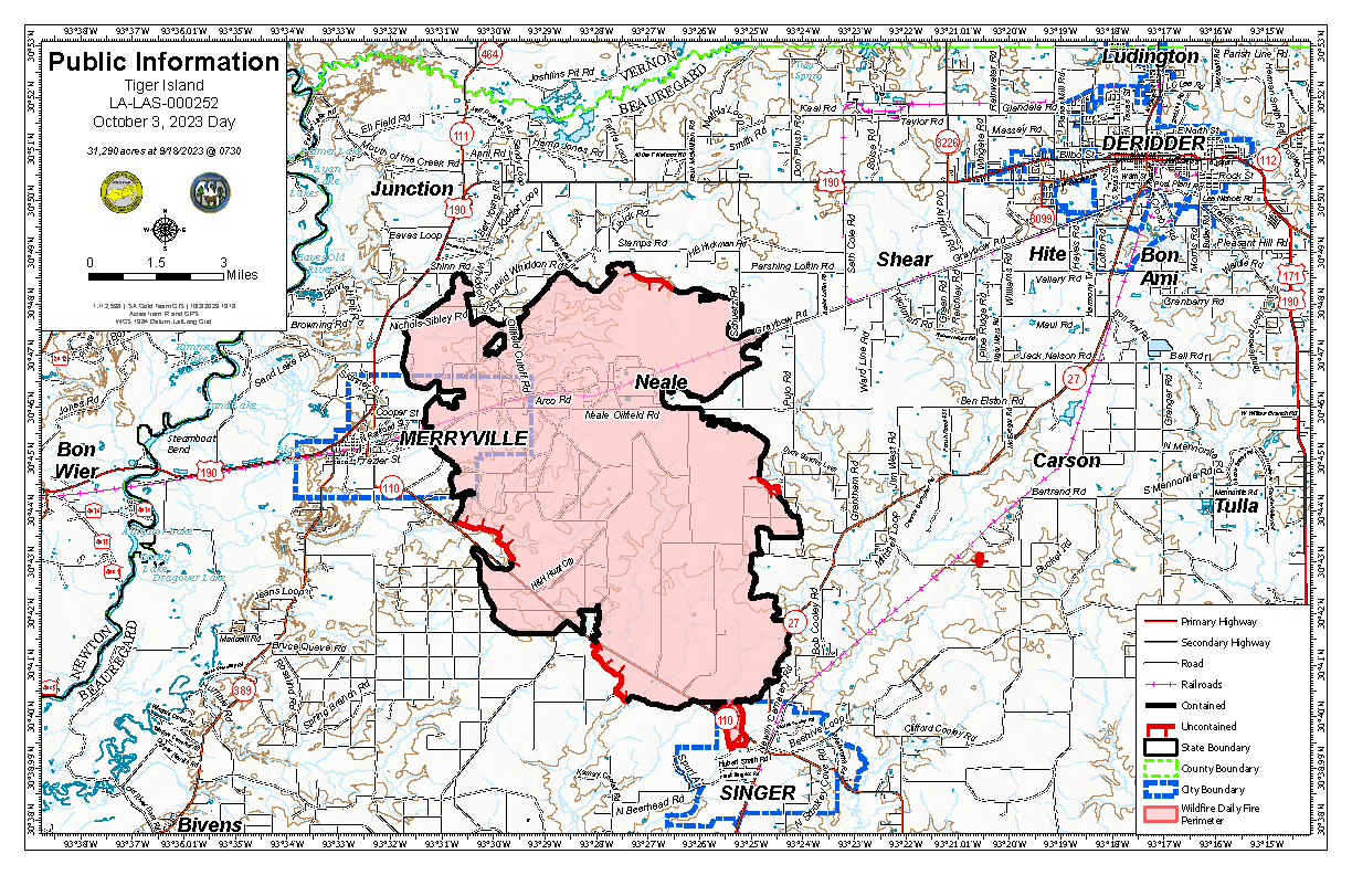
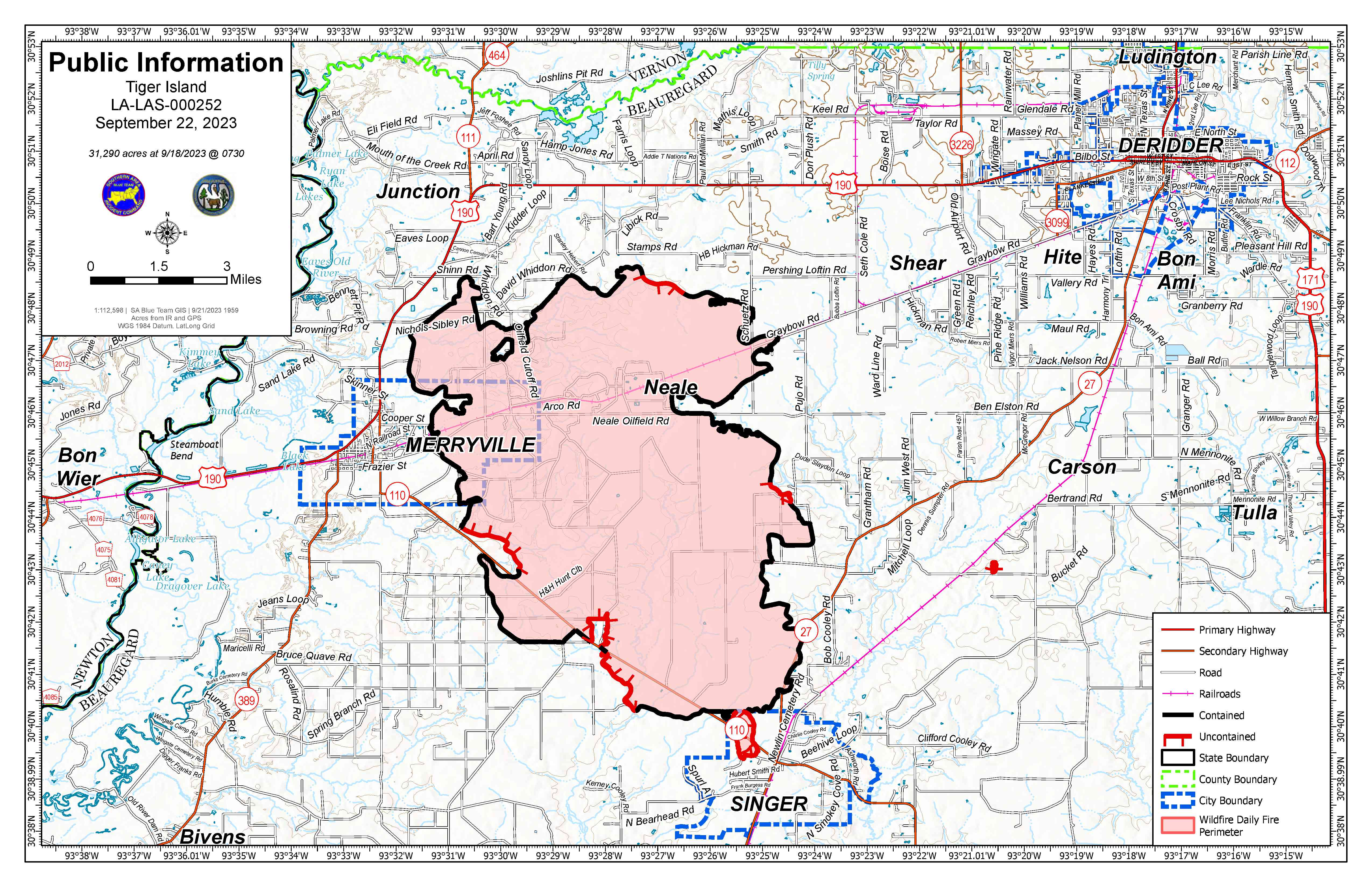
Tiger Island Fire: 31,290 acres, no change | 84% contained| 189 personnel assigned
InciWeb: https://inciweb.nwcg.gov/incident-information/lalas-tiger-island-fire
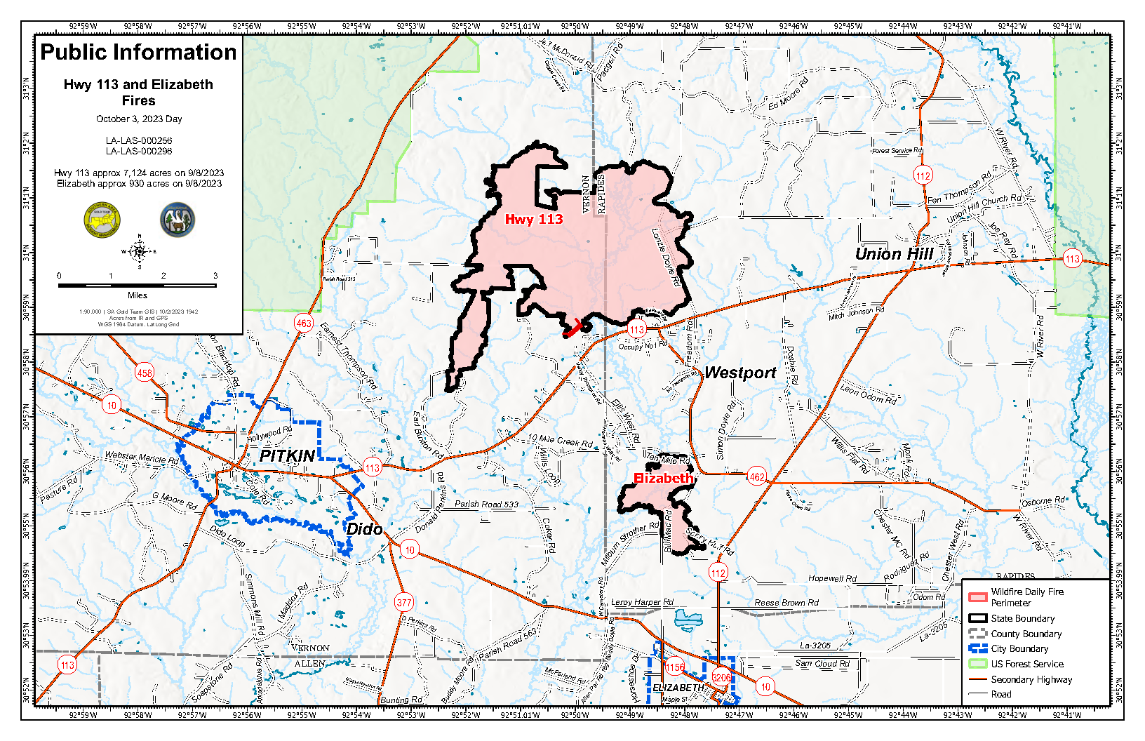
Hwy. 113 Fire: 7,124 acres, no change | 95% contained | 30 personnel assigned
InciWeb: https://inciweb.nwcg.gov/incident-information/lalas-hwy-113-fire
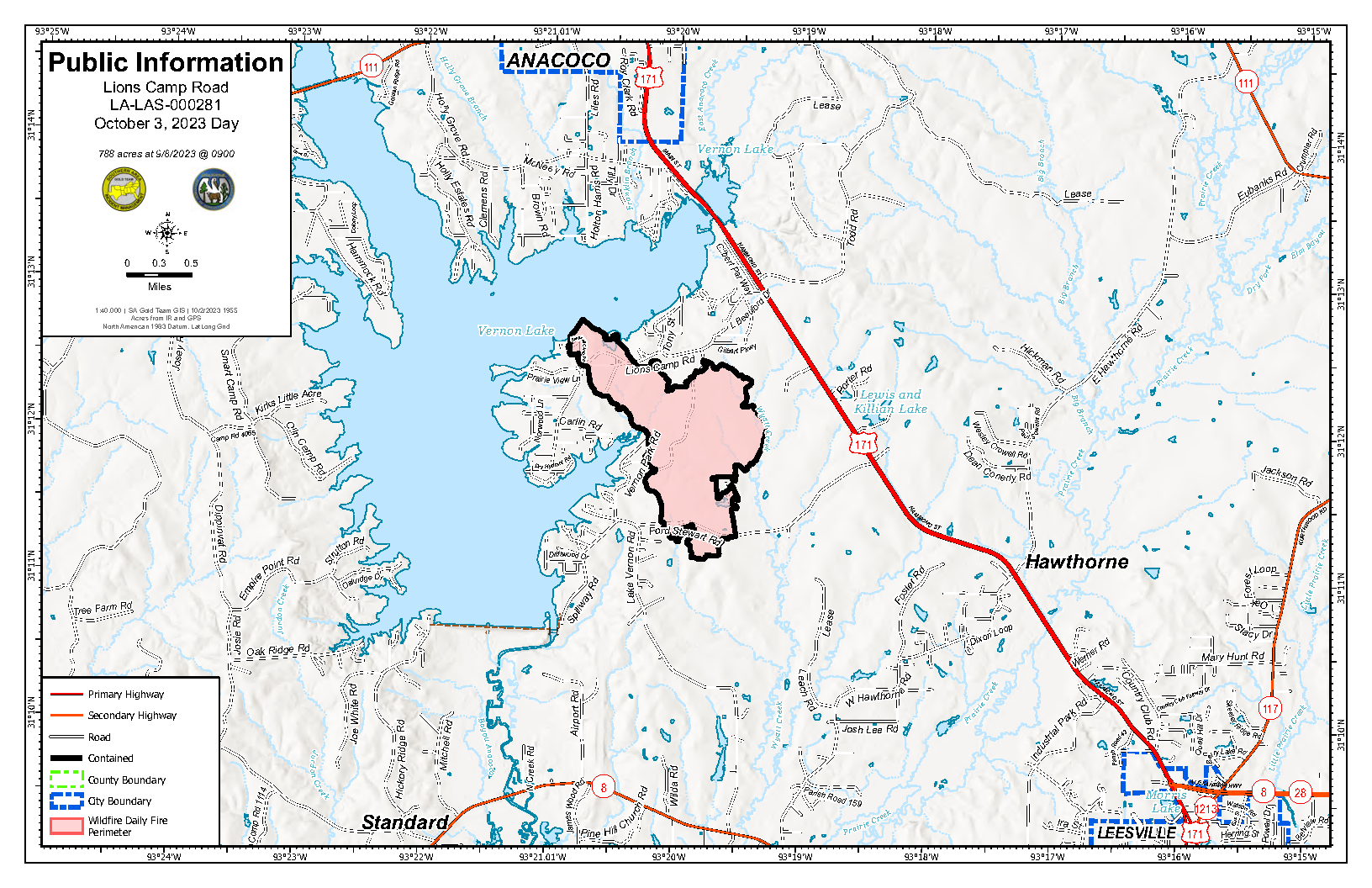
Lions Camp Road Fire: 785 acres, no change | 95% contained | 4 personnel assigned.
InciWeb: https://inciweb.nwcg.gov/incident-information/lalas-lions-camp-road-fire
Elizabeth Fire: 940 acres, no change | 98% contained | 13 personnel assigned
InciWeb: https://inciweb.nwcg.gov/incident-information/lalas-elizabeth-fire
Equipment
Type 6 engines, dozers, tractor plow units, water tenders, medical squads and ambulances and aerial resources including helicopters and fixed-wing aircraft are assigned to the fires. Parish authorities and departments, sheriff’s offices, and the Governor’s Office of Homeland Security and Emergency Preparedness are also providing additional support.
Weather and Fire Behavior
A Red Flag Warning was issued yesterday from 10:00 AM – 8:00 PM for the fires and surrounding area. Today will bring elevated fire danger with hot and unusually dry conditions with breezy afternoons that will favor the initiation and rapid spread of wildfires. Initial attack remains a possibility and fire behavior will be very aggressive for crews responding to those fires. Continuing updates on fire weather conditions are available at https://www.weather.gov/lch/.
Air Quality
Smoke may occur in reburn areas. Air quality information is available at https://fire.airnow.gov.
Temporary Flight Restrictions (TFRs)
TFRs remain in place over the Tiger Island Fire (https://tfr.faa.gov/save_pages/detail_3_3911.html). A smaller, new TFR is in place for the Hwy. 113 and Elizabeth Fires https://tfr.faa.gov/save_pages/detail_3_4065.html). Remember: If you fly, we can’t.
Informacin actual para los incendios Anvil y Flat 3 de octubre 2023
Related Incident: Anvil FireFlat Fire
Publication Type: News
Puntos importantes: Se estará llevando a cabo una reunión para la comunidad acerca del Incendio Anvil y flat, hoy, el martes, 3 de octubre a las 7:00 PM en Sixes Grange. Se estará transmitiendo en vivo:facebook.com/flatfireoregon2023
Incendio Anvil
Área: 22,173 acres Fecha de inicio: 25 de agosto, 2023 Localizado: 8 millas al Este de Port Orford, OR Contención: 45% Personal: 1,127 Recursos: 29 cuadrilla de bomberos, 7 helicópteros, 34 camiones de bomberos
El día de ayer, los bomberos seguían progresando en la construcción líneas de contención sobre el lado oeste del incendio que ya está cerca de finalizar. El perímetro de incendio no había avanzado por culpa de la lluvia y la alta humedad. Los bomberos usaron un helicóptero para derramar agua sobre el área de Elk River Hatchery cuando empezó a calentar el día. Supresión de reparaciones continuo sobre la calle de Sixes River y el grupo de estructura limpió sobre la residencia de Elk River. El progreso también continuo sobre las líneas de contención en el lado norte y oeste del incendio. Las cuadrillas de bomberos sacaron mangueras y otro equipajes y partes de las líneas seguras. En el sudeste del incendio, los bomberos seguían construyendo líneas de contención hacia Milbury Mountain.
Hoy, si el clima permite, las cuadrillas de bomberos aseguraran la línea de contención sobre el lado oeste del incendio. También, las cuadrillas de bomberos localizarán la mejor área para construir líneas secundarias y contingencias para áreas sin contención en terreno inaccesible. Grandes maderas y combustibles aún tienen niveles bajos para humedad. Siempre quedan combustible que están quemando. No se ve lumbre, pero este comportamiento de incendio resulte con producción de humo que puede existir por las semanas que siguen especialmente cuando la temperatura sea más caliente y los combustibles secan.
Evacuaciones: La Oficina del Alguacil para el Condado de curry, creo zonas de evacuación cerca del Incendio Anvil; Zonas 1, 2 y 4 se encuentran en un Nivel 2 “LISTOS”, la Zona 3 se encuentra en un Nivel de evacuación 1 “PREPARESE”. Las condiciones climáticas podrían cambiar rápidamente. Por favor, este atento a la información actualizada. Para revisar un mapa interactivo de evacuación, visite: https://bit.ly/AnvilEvacs. Puede registrarse en el sistema de Alertas de emergencias para el condado: https://bit.ly/CurryCoEMIncendio Flat
Incendio Flat
Área: 34,242 acres Inicio:15 de julio, 2023 Localizado: 2 millas Sureste de Agness, OR Contención: 88% Personal: 48 Recursos: 1 cuadrilla de bombero y 3 camiones de bombero
Excavadoras continúan de reparar líneas de supresión en el lado norte del incendio. La cuadrilla de bombero está trabajando para mitigar peligros de arboles y reparar calles.
Las áreas para Emergencia de Incendio y las Ordenes de Cierre de Carreteras aún se encuentran en efecto: Permanece en pie la Orden de Cierre para los incendios Anvil y Flat. La reciente precipitación a través del bosque ha permitido levantar las Restricciones de Uso Público, permitiendo el uso de fogatas en áreas en donde el bosque no se encuentra bajo Ordenes de Cierre. Tenga en cuenta que esta Orden referida a fogatas, no elimina la Orden de Cierre de caminos. El personal forestal se encuentra trabajando de manera cercana con los manejadores del incendio en la evaluación de medidas de cierre y buscando el momento oportuno para levantarlas tan pronto como sea posible para los bomberos y para el público en general. Puede encontrar mapas e información más detallada en: https://bit.ly/RRSNFAlerts o https://inciweb.wildfire.gov/incident-closures/orrsf-anvil-fire.
Restricciones: El Bosque Nacional de Rogue River Siskiyou, levanto todas las Restricciones en las tierras del bosque para uso del público, moviendo el Nivel de Peligro de Incendio a “Moderado” y reduciendo el Nivel de Precaución de Incendios a Nivel 1. Restricciones para el Publico en la sección silvestre de Rogue River, se encuentran en una Fase 1 – el cual se refiere a uso de fogatas en un sartén para fuego y a una altura más baja del nivel del agua.
Condiciones climáticas: Existe una ligera posibilidad de lluvias en horas de la tardeal darse paso el frente pasando hacia el Norte. Las temperaturas se incrementarána lo largo dela semana.
Condiciones del humo: Se podrá ver la presencia del humo de vez en cuando durante el día. Para información actualizada en cuanto a la presencia del humo y la calidad del aire, visite: https://bit.ly/SWORsmoke. Por favor conduzca despacio y con las luces encendidas a través de cualquier área de incendio.
Carreteras: Visite www.tripcheck.com o llame 511 para información al día acerca de cierres de carreteras. Por favor no utilice las carreteras forestales como una ruta alternativa.
Líneas Informativas: (541) 216-4579 o (541) 237-6369
Email: 2023.anvil@firenet.gov
Facebook: facebook.com/flatfireoregon2023
X/Twitter: twitter.com/RRSNF
Inciweb Anvil Fire: bit.ly/AnvilFireOR
Inciweb Flat Fire: bit.ly/FlatFireOR
Anvil and Flat Fires Update October 3 2023
Related Incident: Anvil FireFlat Fire
Publication Type: News
Highlight: There will be a public meeting for the Anvil and Flat fires tonight, Tuesday October 3 at 7:00 PM at the Sixes Grange. The meeting will also be streamed live at facebook.com/flatfireoregon2023
Anvil Fire
Size: 22,173 acres Start Date: August 25, 2023 Location: 8 miles east of Port Orford, OR
Containment: 45% Total personnel: 1,127 Resources: 29 crews, 7 helicopters, 34 engines
Firefighters continue making progress constructing containment lines on the west side of the fire and nearing completion. Rain and higher humidities has resulted in no perimeter growth. Yesterday a helicopter assisted firefighters with bucket drops when an area above the Elk River Hatchery began to show more heat. Suppression repair work continues along the Sixes River Road and a structure group has been cleaning up around residences along the Elk River. Progress continues on containment lines on the north and west side of the fire. Crews have been backhauling - removing hose and other equipment from secured portions of the line. On the southeast perimeter of the fire, firefighters continue to build contingency lines south towards Milbury Mountain.
Today, weather permitting, crews will work on completing containment lines on the west side of the fire. Work is ongoing to identify and begin construction of secondary and contingency lines for uncontained areas of the fire in inaccessible terrain. Large timber and heavier fuels still have below average moisture levels. Smoldering may become more active in the coming days as temperatures rise and humidities drop. Additional isolated smokes will be visible as temperatures warm back up and fuels begin drying back out.
Evacuations: Curry County Sheriff’s Office has identified evacuation zones near the Anvil Fire: Zones 1, 2, and 4 are in Level 2 “Set” status. Zone 3 is in Level 1 “Ready” status. Conditions may change quickly. Monitor for updates in evacuation levels. View the interactive evacuation map at https://bit.ly/AnvilEvacs. Sign up for Curry Co. emergency alerts at https://bit.ly/CurryCoEM.
Flat Fire
Size: 34,242 acres Start Date: July 15, 2023 Location: 2 miles southeast of Agness, OR Containment: 88% Total personnel: 48 Resources: 1 crew, 3 engines
Excavators continue to repair suppression lines on the northern perimeter of the fire. Crews are working to mitigate hazard trees and repair roads.
Emergency Fire Area and Road Closures Still in Effect: Forest closures remain in place in both fire areas. Recent precipitation across the forest allowed for the lifting of Public Use Restrictions, which allows campfires on areas of the forest that are not currently under a closure order. Lifting Public Use Restrictions for campfires does not rescind closure orders. Forest staff are working closely with fire managers daily to re-evaluate closures and look for opportunities to reopen them as soon as safely possible for both firefighters and the public. For current closure information and maps, please visit: https://bit.ly/RRSNFAlerts or https://inciweb.wildfire.gov/incident-closures/orrsf-anvil-fire.
Fire Restrictions: The Rogue River-Siskiyou National Forest lifted all Public Use Restrictions on Forest Service lands and moved to “moderate” fire danger. The Industrial Fire Precaution Level was reduced to Level 1. Public Use Restrictions on the Wild Section of the Rogue River are at Stage 1- campfires must be in a fire pan below the high-water mark.
Weather: Light rain fell over the fire yesterday afternoon and will continue until noon today. Temperatures will warm and winds will increase after the front passes.
Smoke: Smoke may be visible at times. For current smoke and air quality updates visit, https://bit.ly/SWORsmoke . Please drive slowly and with headlights on through any fire area.
Roads: Visit www.tripcheck.com or call 511 for current road closures. Do not use forest roads for alternate routes.
Contact Fire Information: (541) 216-4579 or (541) 237-6369
Email: 2023.anvil@firenet.gov
Facebook: facebook.com/flatfireoregon2023
X/Twitter: twitter.com/RRSNF
Inciweb Anvil Fire: bit.ly/AnvilFireOR
Inciweb Flat Fire: bit.ly/FlatFireOR
Fact Sheet for the Hope Fire October 3 2023
Related Incident: Hope Fire
Publication Type: News
![]()
The Hope Fire was lightning-caused and detected on September 21st. The fire is being managed under a full suppression strategy by local resources from the Dolores Ranger District of the San Juan National Forest. It is currently burning at Hoppe Point located northwest of the McPhee Dam and Reservoir, east of Bradfield Campground.
The location of the fire is within the boundaries of a prescribed fire burn unit. Fire personnel have been working to prepare lines around the estimated 3,000-acre section. Firefighters are reinforcing and using previously defined and prepared control lines to allow this naturally caused wildfire to reduce forest fuels and improve forest health within those boundaries. This will decrease risk of future catastrophic wildfire, protect infrastructure and private lands, and improve forage for wildlife.
Current
- Rain over the area diminished fire behavior on Monday.
- Today, firefighters will work to improve line and patrol the fire’s edge as the weather trends toward a drying period.
Outlook
- Cooler and drier temperatures today will transition to a warming trend later in the week.
- Firefighters will continue patrolling and improving lines in anticipation of the anticipated change in the weather.
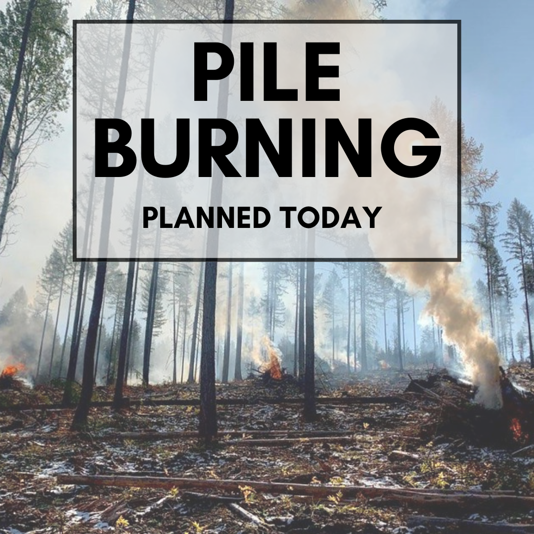
October 3 2023 Pile Burn Update
Related Incident: Lolo National Forest Prescribed Fire Operations
Publication Type: Announcement
Pending conditions, several districts on the Lolo National Forest are planning to conduct pile burns today to reduce hazardous fuels from previous vegetation management operations.
Pile burning is commonly used to mitigate wildfire risk in areas where broadcast burning may not be feasible, such as adjacent to communities or private lands. Piles are made from the residual woody debris often left after a mechanical thinning treatment and can range in size from small hand stacked piles to large piles created with mechanical equipment. Piles are typically burned in fall, winter, or early spring after the piles have dried out and conditions allow, reducing the damage to the remaining trees and confining the majority of fire to the footprint of the pile.
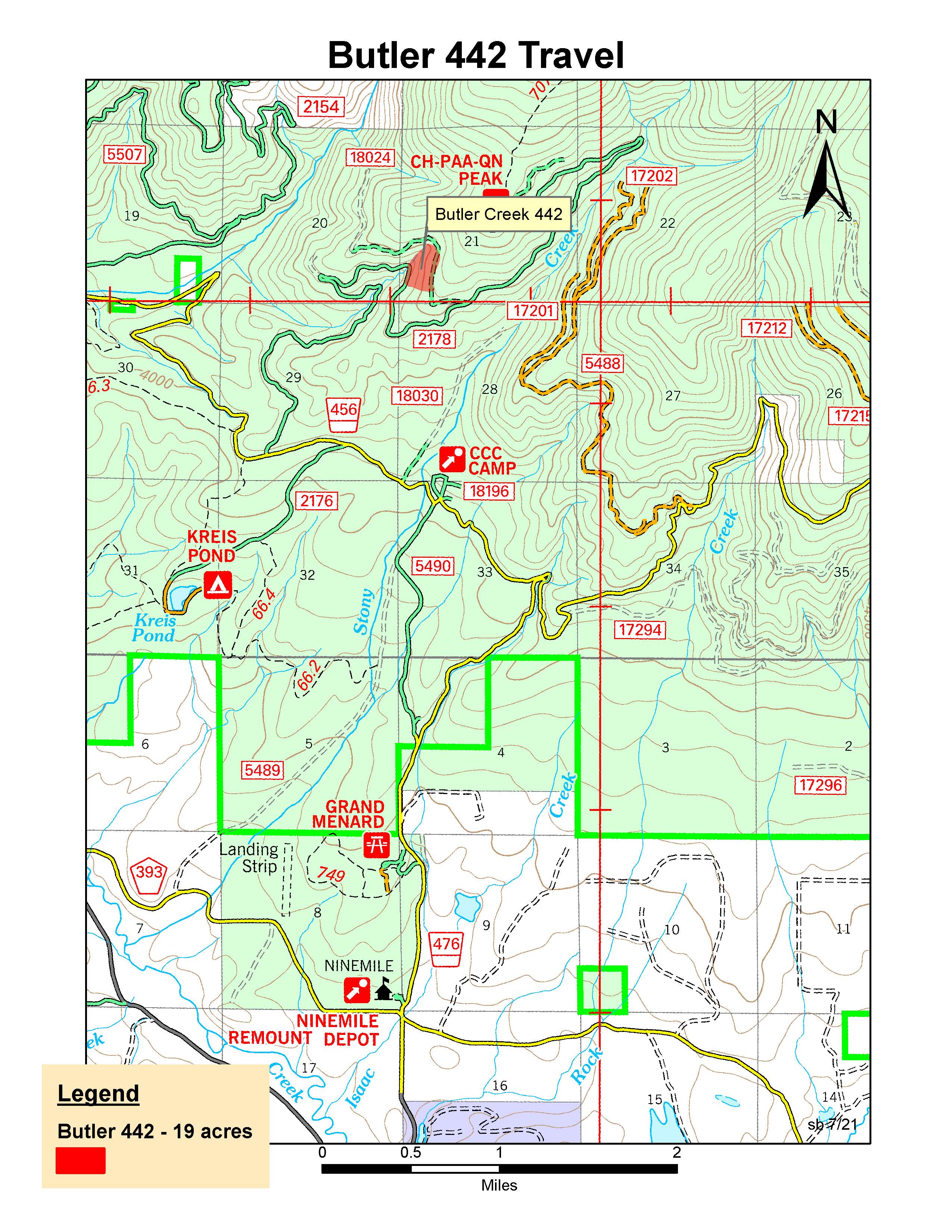
Ninemile Ranger District: 24 firefighters will conduct up to 10 acres of hand pile burning 4 miles north of Ninemile District Office in Huson, MT. Smoke may be visible from Huson, Butler Creek, and the Ninemile Valley.
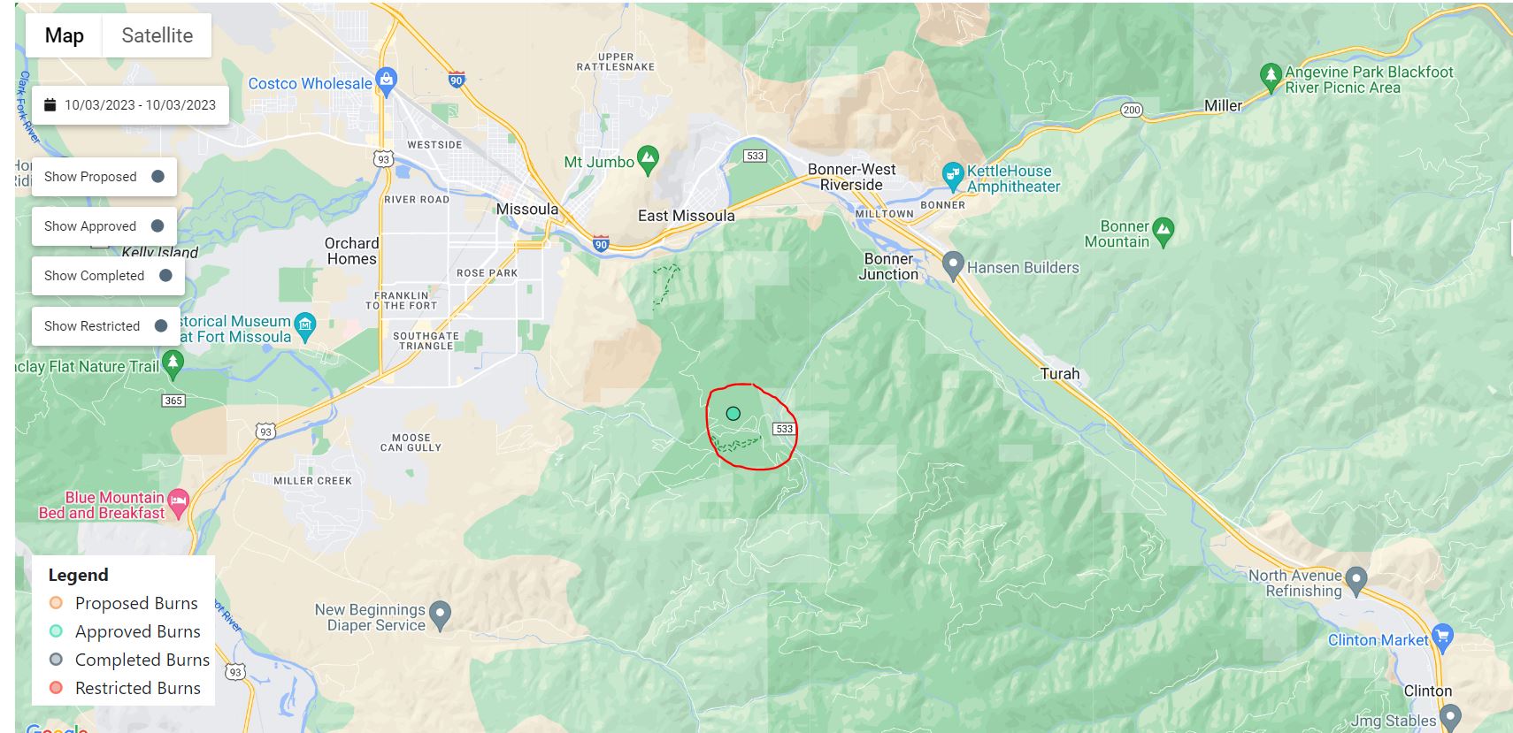
Missoula Ranger District: Firefighters will conduct up to 10 acres of hand pile burning located 15 miles southeast of Missoula, MT in the Pattee Canyon Disk Golf Course area. Smoke may be visible from the Missoula, Bonner, and parts of the I-90 corridor.
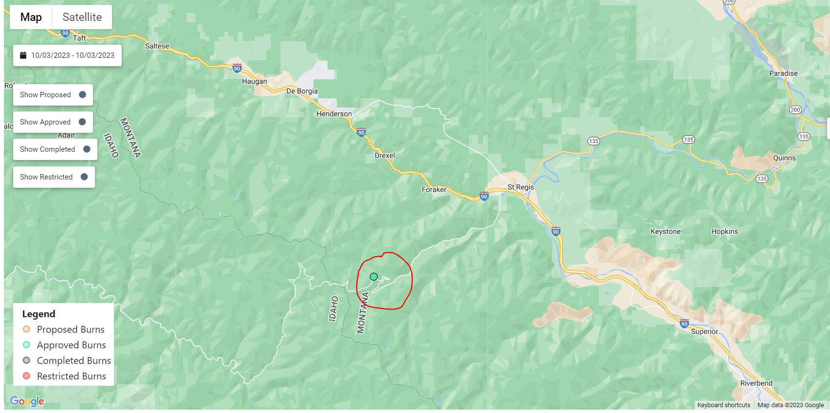
Superior Ranger District: Firefighters will conduct up to 45 acres of hand pile burning located 7 miles southwest of St. Regis, MT in Cold Creek. Smoke may be visible from the St. Regis and surrounding areas.
Firefighters will patrol and monitor the burning over the next few days.

2023 Area Closure 10 06 2023
Related Incident:
Publication Type: Announcement
A closure order in in effect for the Blue Ridge Prescribed Burn area. See a map and more details.
Described Area is south of Hot Sulphur Springs, Colorado along Blue Ridge in Sections 18, 19, 20, 29 and 30, Township 1 North, Range 77 West; and Sections 13, 14, 23, 24, 25 and 26, Township 1 North, Range 83 West; 6th P.M. It includes all NFS lands within the following boundaries: beginning at the junction of NFS road (NFSR) 133 (Beaver Creek) and Spring Creek, following the ridge to its junction with NFSR 253.1D, following NFSR 253.1D to its junction with NFSR 253, following NFSR 253 east to its Order Number: # ARP-SRD-2023-10 junction with NFSR 253.1F, following the ridge south to its junction with NFSR 133, following NFSR 133 east and ending at its junction with Spring Creek. The Described Roads include the following NFSR in their entirety, unless otherwise noted, which are within, border, or adjacent to the Described Area: NFSR 253.1B, 253.1C, 253.1D, 253.1E, 253.1F, 253.1G, 253.1H, 253.1I, 253.1J, 253.1K, 253.1L, 253.1N, and the portion of 253 beginning at its junction with NFSR 253.2 and 253.2H extending west for 3.6 miles.
Update 10022023
Related Incident: Cow Creek Prescribed Burn
Publication Type: Announcement
Fire personnel continued to monitor the #CowCreekRx burn area over the weekend. The burn area had minimal fire behavior and minimal smoke, which came primarily from the interior of the burn area.
With a current trend of colder and wetter weather, firefighters will continue to monitor the Cow Creek Prescribed Burn area and the GMUG will be assessing for a return of favorable prescribed burning conditions for Unit 2 for the #CowCreekRx burn.
For more information on how prescribed fire smoke may affect your health, please visit https://www.colorado.gov/pacific/cdphe/wood-smoke-and-health
Prescription (RX) burning is important to maintain a fire-adapted ecosystem and is essential for wildfire prevention. For more information on prescription burning and its use, please visit: https://www.fs.usda.gov/managing-land/prescribed-fire
Hope Fire Daily Update Oct 2
Related Incident: Hope Fire
Publication Type: News
Fact Sheet for the Hope Fire – October 2, 2023
The Hope Fire was lightning-caused and detected on September 21st. The fire is being managed under a full suppression strategy by local resources from the Dolores Ranger District of the San Juan National Forest. It is currently burning at Hoppe Point located northwest of the McPhee Dam and Reservoir, east of Bradfield Campground.
The location of the fire is within the boundaries of a prescribed fire burn unit. Fire personnel have been working to prepare lines around the estimated 3,000-acre section. Firefighters are reinforcing and using previously defined and prepared control lines to allow this naturally caused wildfire to reduce forest fuels and improve forest health within those boundaries. This will decrease risk of future catastrophic wildfire, protect infrastructure and private lands, and improve forage for wildlife.
Current
- Despite increased winds yesterday, fire activity remained low and acreage remained at 1,290 acres.
- Rain is forecast for today and firefighters will take advantage of the weather to improve containment lines.
Outlook
- Rain today will transition into cooler and drier weather tomorrow.
- Firefighters will continue patrolling and improving lines in anticipation of a warming and drying trend beginning midweek.
For Hope Fire Information:
2023.hope@firenet.gov
inciweb.nwcg.gov/incident-information/cosjf-hope-fire
Fire information line: (541)-802-3112
Quartz Ridge Bear Creek Fires Update100223
Related Incident: Bear Creek FireQuartz Ridge Fire
Publication Type: News
Update: October 2, 2023
Type 3 Team, Incident Commander: Scotty Nilson
Updates will be produced every other day unless significant activity occurs
Highlights:
Multiple days of rainfall have reduced fire behavior to a minimum on both the Quartz Ridge and Bear Creek Fires. Firefighters have removed some of the structure protection equipment in place near the Bear Creek fire that is no longer needed.
On Tuesday, October 3, command of both fires will be turned over to a smaller type 4 organization.
Quartz Ridge Fire: 2,850 acres | 22 personnel assigned
The fire received rainfall on Saturday and Sunday. Firefighters have continued to patrol and use spotters to keep an eye out for fire activity. Infrared on September 29 showed very little heat along the edges or within the perimeter.
The fire is located in steep, remote terrain in the San Juan Wilderness, 13 miles northeast of Pagosa Springs.
Bear Creek Fire: 1,094 acres | 24 personnel assigned
A few isolated areas of heat continue to produce smoke, mainly when there is direct sunlight hitting them. Rain showers over the weekend have dampened fire activity and smoke output. On Sunday, firefighters removed structure protection equipment from homes and ranch properties in the southern Weminuche Valley. The fire is no longer considered a threat to those southern valley properties. Firefighters will keep structure protection equipment in place in the northern part of the Weminuche Valley until fire managers conclude it is no longer needed.
Weather:
More rain and cooler temperatures for the early part of the week. Measurable rainfall is predicted for Monday, with winds gusting to 35 mph. Tuesday will be slightly less windy with a smaller chance of rain and high temps in the 50s.
San Juan NF Temporary Closures: The closure order for the Quartz Ridge Fire has been amended. Quartz Meadows Rd (NFSR#684) and the Quartz Ridge Trail (NFST#570) have re-opened. Quartz Creek Trail (NFST#571) remains closed. In the Bear Creek Fire area, Little Sand Trail (NFST #591) and Shaw Creek Trail (NFST#584) are closed. For more info: Quartz Ridge Closure and Bear Creek Closure.
Prescribed Fire: There has been increased smoke production this week caused by prescribed burning in locations on the San Juan National Forest. For the most up to date and detailed information, visit https://inciweb.nwcg.gov/incident-maps-gallery/cosjf-san-juan-national-forest-prescribed-fire-program
2023 PRESS RELEASE Blue Ridge Prescribed Burn could resume as early as October 9 202310 09 2023
Related Incident:
Publication Type: News
Granby, Colo. (Oct. 2, 2023) – Arapaho National Forest fire managers and their partners are monitoring conditions for an opportunity in the coming weeks to continue the Blue Ridge prescribed fire project, located near Cottonwood Pass. Implementing prescribed fire is a critical part of reducing the risk of wildfire to communities and improving forest health conditions in Grand County. Blue Ridge is the geographic feature that runs North-South from Granby to Fraser, between the East Troublesome, Church Park and Williams Fork fires. Improving forest health conditions in this area is a key component of the Hot Sulphur, Fraser and Grand County Community Wildfire Protection Plans.
In past seasons, Arapaho National Forest firefighters with the help of many local cooperating agencies have successfully burned approximately 500 acres in the Blue Ridge area. This fall, fire managers are preparing to burn up to 1200 acres over multiple days, starting in Big Meadows south of Cottonwood Pass. Several local cooperating agencies will be involved. If conditions allow, burning could begin as soon as October 9, 2023.
Smoke from these activities could be visible from many areas in the county, including Parshall, Granby and parts of the Fraser Valley. Firefighters work closely with experts to minimize the impacts of smoke, and air quality is carefully monitored before and during a prescribed fire. All prescribed burns comply with state air quality regulations to minimize impacts. To learn more about the potential health impacts of smoke visit the Colorado Department of Public Health and Environment.
Prescribed fire is only implemented under very specific environmental conditions (e.g., wind speed, relative humidity, smoke dispersion). Prescribed fires are conducted by trained fire managers with a strong understanding of fire behavior and years of on-the-ground experience. These prescribed burns will only be implemented when pre-identified and contingency firefighting resources are available to support safe operations. Fire managers develop containment lines in advance by building fire line by hand, laying hose, and identifying existing fire breaks and natural barriers such as ridges, rivers, and roads. This helps keep the prescribed fire within its planned perimeter. Fire managers staff the fire until it is deemed secure and patrol the prescribed fire until it is declared out.
Even with the most thorough planning and preparation, the use of prescribed fire carries an innate level of risk that cannot be eliminated entirely. However, prescribed fire is one of the most efficient ways of reducing wildfire risk. Regularly conducting prescribed fires, which mimic nature, reduces the buildup of flammable vegetation and overgrowth.
This prescribed burn is part of the overall strategy on the Arapaho and Roosevelt National Forests to address the Wildfire Crisis. Prescribed fire is one of the most efficient ways of reducing wildfire risk. Regularly conducting prescribed fires, which mimic nature, reduces the buildup of flammable vegetation and overgrowth.
To receive updates, follow us on Facebook and Twitter, and join our email list through Constant Contact and select the list "Forest Health & Fire: Grand County (Winter Park, Fraser, Granby, Grand Lake, Hot Sulphur)."