
Settings - change map background and toggle additional layers
Filter - control incident types displayed on map.
Zoom to your location
Reset map zoom and position
Could not determine your location.
Show Legend
 Wildfire
 Prescribed Fire
 Burned Area
Response
Burned Area
Response Other
Other
2023 Black Bear Fire
Unit Information
Incident Contacts
Matts Creek Fire Morning Update Nov 15 2023
Related Incident:
Publication Type: News
Current Status: The Matts Creek Fire is 5 miles southeast of Glasgow, Virginia and 5 miles northwest of Big Island, Virginia. The fire is located south of US-501 and the James River within the James River Face Wilderness on the Jefferson National Forest.
The entire fire is on National Forest lands, there are no structures threatened.
Estimated Acreage: 1400 acres
County: Bedford County
Containment: 0% contained
Date and Cause Reported: The fire was reported on Sunday, November 12, 2023. The cause of this fire is undetermined.
Resources on the Fire: Approximately 80 firefighters and support staff, this includes 4 fire crews, 1 type-6 engine, and 3 Type 1 helicopters.
Incident Objectives:
• Safety of the public, firefighters, and aviation resources is always the number one priority.
• Protect and minimize threats to all private property and other identified properties in and around Hunt Club Road (FSR54) and Peters Creek Road (SR600) in Bedford County utilizing manmade features such as trail systems, roads, and other natural barriers.
Smoke and Air Quality: Winds will be light today so smoke may occur in nearby communities. For information on air quality visit www.AirNow.gov
Cooperators: National Park Service-Blue Ridge Parkway, Bedford County Fire & Rescue, Amherst County Public Safety, Rockbridge County Fire-Rescue & Emergency Management, Virginia Department of Transportation, Virginia Department of Forestry.
Wilderness Area Closures: The James River Face Wilderness and all associated trails, including a section of Appalachian National Scenic Trail, are closed to all public use due to the on-going wildland fire.
The following areas are temporarily closed to allow for public and fire fighter safety:
• Appalachian Trail (FT #1) from James River Foot Bridge to Petite’s Gap Road (FR #35)
• James River Foot Bridge Parking Lot
• Matts Creek Trail (FT #4/Old A.T.)
• Piney Ridge Trail (FT #2)
• Balcony Falls Trail (FT #7)
• Gunther Ridge Trail (FT #8)
• Belfast Trail (FT #9)
• Sulphur Springs Trail (FT# 3001)
Use caution and obey all road signs for your safety. Motorists should be alert for firefighter vehicles and smoke.
Fire Restrictions:
Stage 1 Fire Restrictions in effect: For the protection of public health and safety, the following acts are prohibited on all lands administered by George Washington & Jefferson National Forest.
1. Building, maintaining, attending, or using a fire or campfire outside of developed recreation sites.
2. Possessing, discharging, or using any kind of firework or other pyrotechnic device.
Campfires in a Forest Service provided metal fire pit, ring or grill at a developed recreation site are allowed.
General Fire Information:
• Safety of the public and firefighters is always the number one priority when dealing with wildfires.
• Homeowners can learn how to make their homes less susceptible to wildfires by visiting: www.firewise.org
For fire updates: https://inciweb.wildfire.gov/incident-information/vavaf-matts-creek-fire
Visit forest information for the George Washington & Jefferson National Forests website www.fs.usda.gov/gwj or follow us on Facebook: www.facebook.com/GWJNF
Matts Creek Fire Evening Update Nov 14 2023
Related Incident:
Publication Type: News
Current Status: The Matts Creek Fire is 5 miles southeast of Glasgow, Virginia and 5 miles northwest of Big Island, Virginia. The fire is located south of US-501 and the James River within the James River Face Wilderness on the Jefferson National Forest.
The entire fire is on National Forest lands, there are no structures threatened.
Estimated Acreage: 1200 acres
County: Bedford County
Containment: 0% contained
Date and Cause Reported: The fire was reported on Sunday, November 12, 2023. The cause of this fire is undetermined.
Resources on the Fire: Approximately 80 firefighters and support staff, 1 type 6 engine, 3 Type 1 helicopters, and 2 fixed wing air tankers using water only.
Wilderness Area Closures: The James River Face Wilderness and all associated trails, including a section of Appalachian National Scenic Trail, are closed to all public use due to the on-going wildland fire.
The following areas are temporarily closed to allow for public and fire fighter safety:
- Appalachian Trail (FT #1) from James River Foot Bridge to Petite’s Gap Road (FR #35)
- James River Foot Bridge Parking Lot
- Matts Creek Trail (FT #4/Old A.T.)
- Piney Ridge Trail (FT #2)
- Balcony Falls Trail (FT #7)
- Gunther Ridge Trail (FT #8)
- Belfast Trail (FT #9)
- Sulphur Springs Trail (FT# 3001)
Use caution and obey all road signs for your safety. Motorists should be alert for firefighter vehicles and smoke.
Fire Restrictions:
Stage 1 Fire Restrictions in effect: For the protection of public health and safety, the following acts are prohibited on all lands administered by George Washington & Jefferson National Forest.
1. Building, maintaining, attending, or using a fire or campfire outside of developed recreation sites.
2. Possessing, discharging, or using any kind of firework or other pyrotechnic device.
Campfires in a Forest Service provided metal fire pit, ring or grill at a developed recreation site are allowed.
General Fire Information:
- Safety of the public and firefighters is always the number one priority when dealing with wildfires.
- Homeowners can learn how to make their homes less susceptible to wildfires by visiting: www.firewise.org
For fire updates: https://inciweb.wildfire.gov/incident-information/vavaf-matts-creek-fire
Visit forest information for the George Washington & Jefferson National Forests website www.fs.usda.gov/gwj or follow us on Facebook: www.facebook.com/GWJNF
Matts Creek Fire Morning Update Nov 14 2023
Related Incident:
Publication Type: News
Current Status: The Matts Creek Fire is 5 miles southeast of Glasgow, Virginia and 5 miles northwest of Big Island, Virginia. The fire is located south of US-501 and the James River within the James River Face Wilderness on the Jefferson National Forest. The entire fire is on National Forest lands, there are no structures threatened.
Estimated Acreage: 150 acres
County: Bedford County
Containment: 0% contained
Date and Cause Reported: The fire was reported on Sunday, November 12, 2023. The cause of this fire is undetermined.
Resources on the Fire: Approximately 57 firefighters and support staff, 1 type-6 engine and 2 Type 1 helicopters.
Wilderness Area Closures: The James River Face Wilderness and all associated trails, including a section of Appalachian National Scenic Trail, are closed to all public use due to the on-going wildland fire.
The following areas are temporarily closed to allow for public and fire fighter safety:
- Appalachian Trail (FT #1) from James River Foot Bridge to Petite’s Gap Road (FR #35)
- James River Foot Bridge Parking Lot
- Matts Creek Trail (FT #4/Old A.T.)
- Piney Ridge Trail (FT #2)
- Balcony Falls Trail (FT #7)
- Gunther Ridge Trail (FT #8)
- Belfast Trail (FT #9)
- Sulphur Springs Trail (FT# 3001)
Use caution and obey all road signs for your safety. Motorists should be alert for firefighter vehicles and smoke.
Fire Restrictions:
Stage 1 Fire Restrictions in effect: For the protection of public health and safety, the following acts are prohibited on all lands administered by George Washington & Jefferson National Forest.
1. Building, maintaining, attending, or using a fire or campfire outside of developed recreation sites.
2. Possessing, discharging, or using any kind of firework or other pyrotechnic device.
Campfires in a Forest Service provided metal fire pit, ring or grill at a developed recreation site are allowed.
General Fire Information:
- Safety of the public and firefighters is always the number one priority when dealing with wildfires.
- Homeowners can learn how to make their homes less susceptible to wildfires by visiting: www.firewise.org
For fire updates: https://inciweb.wildfire.gov/incident-information/vavaf-matts-creek-fire
Visit forest information for the George Washington & Jefferson National Forests website www.fs.usda.gov/gwj or follow us on Facebook: www.facebook.com/GWJNF
Matts Creek Fire Update Nov 13 2023
Related Incident:
Publication Type: News
Current Status: The Matts Creek Fire is 5 miles southeast of Glasgow, Virginia and 5 miles northwest of Big Island, Virginia. The fire is located south of US-501 and the James River within the James River Face Wilderness on the Jefferson National Forest. The entire fire is on National Forest lands.
Estimated Acreage: 15 acres
County: Bedford County
Containment: 0% contained
Date and Cause Reported: The fire was reported on Sunday, November 12, 2023. The cause of this fire is undetermined.
Resources on the Fire: Approximately 40 firefighters and support staff, 1 type-6 engine and 2 Type 1 helicopters.
Restrictions and Closures: The following areas are temporarily closed to allow for public and fire fighter safety:
- Appalachian Trail (FT #1) from James River Foot Bridge to Petite’s Gap Road (FR #35)
- James River Foot Bridge Parking Lot
- Matts Creek Trail (FT #4/Old A.T.)
Use caution and obey all road signs for your safety. Motorists should be alert for firefighter vehicles and smoke.
General Fire Information:
- Safety of the public and firefighters is always the number one priority when dealing with wildfires.
- Homeowners can learn how to make their homes less susceptible to wildfires by visiting: www.firewise.org
For fire updates: https://inciweb.wildfire.gov/incident-information/vavaf-matts-creek-fire
Visit forest information visit the George Washington & Jefferson National Forests website www.fs.usda.gov/gwj or follow us on Facebook: www.facebook.com/GWJNF
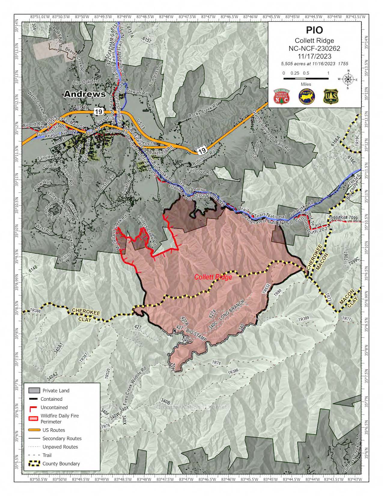
Daily Update Friday November 17 2023
Related Incident: 2023 Collett Ridge Fire
Publication Type: Announcement
5,505 acres | 80% containment | 223 personnel assigned
Highlights: This will be the final update on the Collett Ridge Fire from the Southern Area Incident Management Team Blue Team. The National Forests of North Carolina will assume command of the incident on Saturday, November 18. Crews will continue to monitor and patrol, perform mop-up operations, such as extinguishing any lingering hotspots, and remain available to respond to any new fires. Smoke will continue to be visible as forest floor fuels and snags continue to smolder.
Facebook: https://www.facebook.com/nfsnc/
Resources assigned to the fire include one 20-person handcrew, 1 engine, and 1 dozer. Aerial resources include two helicopters.
Weather & Fire Behavior: A cold front will approach the region today. Winds will shift from the southeast this morning to the west this afternoon. Clouds will gradually increase with an opportunity for showers, with the best chance for wetting showers tonight with amounts of a tenth of an inch or less. Skies will clear for the weekend with fair weather on Saturday and Sunday.
Surface fuels have become dry enough to support conditional fire spread where a heat source is present. Until sufficient precipitation occurs, expect areas of isolated smoldering, primarily in heavy woody fuels, such as log ends, snags, and stumps. Heavy fuel concentrations will retain heat and serve as future heat sources. The primary fire behavior characteristic for the day continues to be isolated smoldering. Smoldering leaf litter may kindle to flame with a little wind and/or sunshine, and burning snags may fall into fresh fuels, such as newly fallen leaves.
Air Quality: Smoke may occur in nearby communities. Air quality information provided by the North Carolina Department of Environmental Quality is available at airquality.climate.ncsu.edu/.
Burn Bans: Due to increased fire risk, the N.C. Forest Service has issued a ban on all open burning until further notice in several counties in western North Carolina. For more information visit https://www.ncforestservice.gov/fire_control/sit_report.htm
The U.S. Forest Service has implemented fire restrictions across the Pisgah and Nantahala National Forests. To view the closure order visit www.fs.usda.gov/alerts/nfsnc/alerts-notices
Temporary Flight Restriction: A Temporary Flight Restriction (TFR) is in place over the Collett Ridge Fire area. If you fly, we can’t. Aircraft or drone intrusions into the restricted airspace endangers aircrews conducting fire operations and aerial resources are grounded for safety. This unnecessarily places aircrews and ground fire crews at risk in a dynamic and dangerous fire environment.
Closures: For public and firefighter safety the following road and area closures are in effect due to increased fire activity and suppression operations in the area from Big Stamp east to Shinbone Ridge to Signal Bald and a road closure is in effect from the intersection of Little Fires Creek Road, 340B, and Fires Creek Road, 340. The Rim Trail is temporarily closed for approximately 7 miles from Big Stamp to Shinbone.
Steep Valley Fire November 17th 2023 Update
Related Incident:
Publication Type: News
GLEN JEAN, WV - The Steep Valley Fire remains at 2,206 acres and containment is up to 81% as of Friday morning, November 17th, 2023. The fire area is in steep and rugged terrain in the War Ridge and Backus Mountain areas, a remote part of the park. The cause of the fire is under investigation. There was minimal fire activity on Thursday which produced isolated pockets of smoke. Air quality levels are expected to improve over the next few days.
This will be the final regular update for the Steep Valley Fire. Resources currently assigned to the fire are being demobilized or dispatched to higher priority incidents throughout the region as Steep Valley Fire operations de-escalate. Further downsizing of personnel is expected after the weekend. Remaining crews will continue to monitor and improve existing lines and scout for any remaining hot spots over the next few days. Management of the fire will transition to a Type 4 local unit at 6:00 AM on Saturday morning, November 18th, 2023. Any fire activity is expected to remain minimal. To date, there has been one minor injury to a firefighter.
A closure order remains in place for the War Ridge and Backus Mountain areas. This closure order will remain in place for the foreseeable future. “We understand this area is a popular hunting spot. To ensure the safety of firefighters, this area remains closed. As things progress, we will reevaluate with fire managers and provide an update on the status of the closure.”, said Charlie Sellars, Superintendent at New River Gorge National Park and Preserve. The closure area includes all National Park Service lands bounded by the New River on the south and west to the town of Quinnimont, due east along State Highway 41 to the intersection of Backus-Red Spring road, then continues directly south to the CSX railroad right of way at the river. The remainder of the park is open for normal hours of operation.
A Temporary Flight Restriction (TFR) remains in effect for 5,000 feet above ground level and a 5-mile radius around the fire area. Any drone incursions into the Steep Valley Fire TFR area are a violation of FAA regulations. Additionally, all aircraft supporting firefighter operations would temporarily be grounded which could put firefighters at extreme risk and could result in grave consequences for those who may be engaged in fire suppression. Remember, If You Fly, We Can’t. As a reminder, launching, landing, or operating a drone within National Park Service lands is strictly forbidden.
With this being the final regular fire update, please visit the park’s Facebook page or check back here for periodic updates.
November 17 2023 Pile Burn Update
Related Incident: Lolo National Forest Prescribed Fire Operations
Publication Type: Announcement
Pile burning is continuing on the Superior Ranger District 3 miles northeast of Superior in the Flat Creek drainage. Smoke may be visible from the Superior and Interstate 90.
Pile burning reduces hazardous fuels contributing to the efforts of the Wildfire Crisis Strategy.
Trail Springs and Mill Creek 2 Fire Update November 16 2023
Related Incident: Trail Springs FireMill Creek 2 Fire
Publication Type: News
Update: November 16, 2023
Type 4, Incident Commander Levi Sensenig, 20 Personnel
The fire danger level is currently HIGH. It is important that forest users completely drown campfires to prevent unintended escape. Use the “drown, stir, feel” method to be sure it's dead out.
Trail Springs Fire | Size: 1358 Acres | Containment: 43% | Cause: Lightning
Updated mapping shows the fire increased 55 acres in size over the last week. That growth is mostly along the northwest edge. It is located 12 miles northwest of Pagosa Springs, burning through grass, brush and dead and down wood. During the recent stretch of warm, dry weather, burning activity and smoke output have been increasing in the afternoon hours. On Thursday, higher humidity levels and possible precipitation should reduce fire activity. The fire remains to the east of West Devil Creek, and firefighters have established containment line to protect values to the east. Firefighters continue to patrol the area to make sure fire activity remains within the defined management area. Crews are also prepared to respond to any new fires within the Pagosa Ranger District.
Mill Creek 2 Fire |
Size: 150 Acres | Containment: 0% | Cause: Human
The fire is located in rugged, remote terrain near the border of the South San Juan Wilderness Area northeast of Pagosa Springs. New mapping information shows minimal (4 acres) growth over the last week. The fire area has significant pockets of standing dead and dead and down trees, which are fueling much of the fire activity. No homes, ranches or other significant values are at risk. Firefighters will continue to closely watch fire activity. Smoke may be visible until the fire gets significant precipitation, and it may increase if windy conditions return.
Weather: Moisture streams up from the Southwest on Thursday, bringing cloud cover higher humidity and a small chance of morning rain showers. High temps will be in the mid-40’s, humidity levels in the upper 20’s and winds out of the SW at 10-15. Sunny skies return on Friday, but the RH levels remain higher, at 35-40%, with SW winds 8-12. Forecasters say there is a chance for some rain or snow over the weekend.
San Juan NF Temporary Closures: An area closure is in place involving roads and trails in or near the Trail Springs Fire area (Middle Mountain area). Details of the closure are in the Closures section of this Inciweb site, and on the “Alerts and Notices” page of the forest website: https://www.fs.usda.gov/alerts/sanjuan/alerts-notices
Fire Information: 970-426-5370 (8 a.m. to 8 p.m.) | Facebook: https://www.facebook.com/sanjuannationalforest
Settings - change map background and toggle additional layers
Filter - control incident types displayed on map.
Zoom to your location
Reset map zoom and position
Could not determine your location.
Show Legend
- Wildfire
- Prescribed Fire
- Burned Area
Response
- Other