
Matts Creek Fire Final Smoke Outlook Nov 22
Related Incident:
Publication Type: News
Special Statement
This will be the LAST OUTLOOK ISSUED by IWFAQRP for this incident. Air quality impacts are expected to be limited to locations directly adjacent to the fire area, and below USG for the duration of the fire season. Thank you for your support, inputs, and feedback!
Fire
Improved mapping accuracy is responsible for the increase in acres burned being reported. No additional fire growth occurred yesterday. Fire crews will now shift their energy to extinguishing any remaining heat sources along the perimeter. Roadside hazards like weakened trees, rockslides, and smoldering stumps will be mitigated to tuck this fire response in for the duration.
Smoke
FOGGY conditions are expected in the local area today with GOOD air quality all day. The leaf litter and brush layer will not be available to burn again until several warm, dry, windy days without any additional moisture occur. Smoldering stumps and logs will produce small pockets of MOD-USG conditions within a mile of Glasgow, but the duration of these impacts will be short. IF dry conditions continue without any additional moisture, expect light smoke, haze, and MODERATE air quality within the forecast area. Very low potentials for extended impacts to exceed USG conditions in the next few weeks. Passing light rain showers, cooler temps, and limited availability of fuels to burn will help keep the air quality between GOOD and MODERATE across the entire forecast area into the winter.
Blue Ridge Parkway Now Open to Public Travel
Related Incident:
Publication Type: Announcement
As of 6:15 p.m. on Tuesday, Nov. 21, the Blue Ridge Parkway is now open to the public for travel.
Firefighters have cleared fire-weakened trees and other debris on and along the parkway making it safe for travel. However, please note that with today's rain, the parkway may be icy at higher elevations and the parkway is still subject to normal winter closures when conditions warrant.
Daily Update Tuesday November 21 2023
Related Incident: 2023 Black Bear Fire
Publication Type: Announcement
Black Bear Fire
Daily Update – Tuesday, November 21, 2023
Southern Area Blue CIMT
1,888 acres | 42% containment | 195 personnel assigned
Highlights: Crews completed the handline along the Groundhog Creek drainage east of the fire completing all primary containment line preparation. Despite winds last night, fire behavior was minimal and containment lines were not tested by the fire. Today will bring breezy conditions and rain, further moderating fire behavior. While flames may not be visible, fuels will continue to smolder, and smoke will be visible.
This will be the final update on the Black Bear Fire from the Southern Area Incident Management Team Blue Team. The National Forests in North Carolina will assume command of the incident on Wednesday, November 22.
Facebook: https://www.facebook.com/nfsnc/
Inciweb: https://inciweb.nwcg.gov/incident-information/ncncf-2023-black-bear-fire
Weather: Heavy rain and gusty winds today with potential for winds from the south and southeast gusting 40-50 mph at times on exposed ridges. Periods of torrential rain could lead to reduced visibility with gusty winds increasing driving hazards. West to northwest winds develop this evening and overnight following the passage of a cold front. Northwest flow over the mountains and lingering moisture will lead to cloudy skies and areas of light rain on Wednesday.
Fire Behavior: Surface fuels will not support active fire spread with wind today. Scattered heavy fuels, such as log ends, snags, and stump holes, will retain heat and may provide a source of ignition in the event of drying in the future. Flare-ups and increased fire activity will not occur with wind. Fire behavior today will be minimal.
Air Quality: No smoke impacts anticipated today. For information regarding smoke impacts and what you can do to protect yourself, visit the North Carolina Department of Environmental Quality Air Quality Portal at airquality.climate.ncsu.edu/.
Burn Bans: Fire restrictions remain in place to help minimize the chances of human-caused wildland fires. These restrictions prohibit campfires outside of established recreation and wilderness areas. www.fs.usda.gov/alerts/nfsnc/alerts-notices.
Temporary Flight Restriction (TFR): There is a flight restriction over the fire area and drones are also prohibited. If you fly, we can't!
Evacuations: None.
Closures: For public and firefighter safety, a closure order is in effect over the fire area. This includes Cold Springs, Harmon Den Mountain, Groundhog, Hickory Ridge, and Skiffely Creek, Chestnut, Carmicheal, and Snowbird Roads. The Appalachian Trail is closed from I-40 to Brown Gap. You can find more information at linktr.ee/blackbearfire. Road closures are in effect for Cold Springs Road and Brown Gap Road. Impacts to travel along Interstate 40 are expected. Check current road conditions at drivenc.gov.
Matts Creek Fire Update Nov 21 2023
Related Incident:
Publication Type: News
Acres: 11,016
Containment: 33%
Cause: undetermined
Total personnel: 380
Start Date: Sunday, November 12, 2023
Location: James River Face Wilderness and Blue Ridge Parkway
Fuels: Mixed hardwoods, shrubby vegetation, and leaf litter
A strong weather system with a large amount of moisture from the Gulf of Mexico and western Atlantic Ocean will bring "prolific rain" to the area today, according to Incident Meteorologist Christian Cassell. Rain will fall all day, intensifying in the evening, with a predicted 1-3 inches across the fire area. As a result, Fire Behavior Analyst Greg Titus said, "Due to the ongoing rain, fire spread is nearly impossible. Do not expect to see active fire today." Due to the good work done to contain the fire, lack of active fire and concern over public and firefighter safety during heavy rain, firefighters will take a pause from field operations today and focus on training and equipment maintenance at the Incident Command Post. Tomorrow, they will return to the fire area to continue work to contain the fire and begin repairs to areas affected by fire suppression operations.
Operations: Yesterday, firefighters continued to improve, mop up and patrol fire lines around the fire perimeter. The fire moved off slopes on the western side of the fire where firefighters conducted an aerial strategic firing operation on Sunday. Firefighters helped bring the fire to containment lines on flatter ground with tactical firing, closing gaps of unburned fuel between the fire and the control lines. Structure protection specialists assessed structures in the Hunt Camp Road area on the eastern side of the fire and in the Arnold Valley area west of the fire.
Investigators have determined that the small, 0.75-acre Hercules Fire near Snowden was caused by human activity and was not the result of a spot fire from the Matts Creek Fire. The Hercules Fire was contained and is in patrol status. The cause of the Matts Creek Fire is still under investigation.
Personnel and equipment on the fire include 7 hand crews, 15 engines, 4 helicopters, 2 water tenders and 1 drone.
Weather and Fire Behavior: With the rain, no active fire behavior is expected. Heat remains in larger fuels and in areas where vegetation is sheltered from the rain. Temperatures will remain in the lower 40s and easterly winds will be 5-10 miles per hour with gusts of up to 12 mph. For tomorrow, temperatures will increase to the mid-50s and northwest winds of 15-20 mph with gusts of up to 30 mph.
Smoke and Air Quality: An incident air resource advisor issues smoke reports at https://outlooks.wildlandfiresmoke.net/outlook. For more information on air quality visit AirNow.gov. Please use caution when driving in low-visibility areas.
Temporary Flight Restrictions: A Temporary Flight Restriction is in place around the fire area. Further information can be found at https://tfr.faa.gov/save_pages/detail_3_4016.html
Road Closures: Petites Gap Road (FSR35) is closed to all public use between the Belfast Trailhead and the Blue Ridge Parkway.
Blue Ridge Parkway Temporary Closure: The Blue Ridge Parkway is closed from milepost 66.3, near US Highway 501, to milepost 85.9, at VA Route 43 until further notice. Park visitors should plan for a detour from the north or south using adjacent routes and Interstate 81.
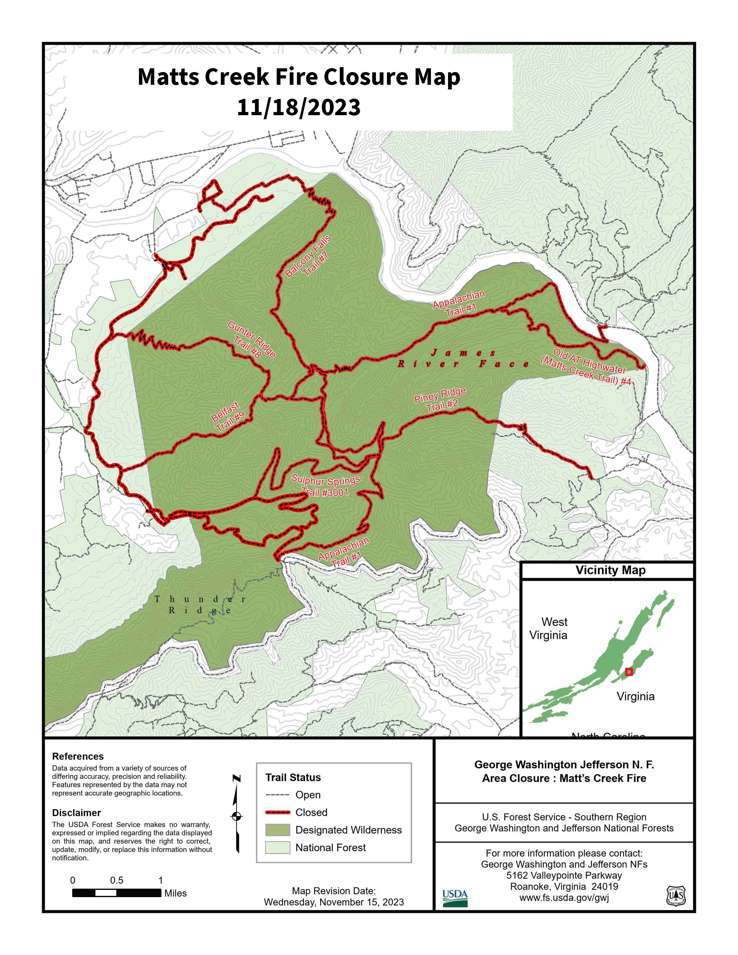
Closures: The James River Face Wilderness and all associated trails, including a section of Appalachian National Scenic Trail, are closed to all public use due to the on-going wildland fire.
The following areas are temporarily closed to allow for public and fire fighter safety:
- Locher Tract
- Glenwood Horse Trail (FT#3004) from the Blue Ridge Parkway to the Hellgate Trailhead
- Appalachian Trail (FT #1) from James River Foot Bridge to Petites Gap Road (FR #35)
- James River Foot Bridge Parking Lot
- Matts Creek Trail (FT #4/Old A.T.)
- Piney Ridge Trail (FT #2)
- Gunther Ridge Trail (FT #8)
- Belfast Trail (FT #9)
- Sulphur Springs Trail (FT# 3001)
Use caution and obey all road signs for your safety. Motorists should be alert for firefighter vehicles and smoke.
Fire Restrictions:
Stage 1 Fire Restrictions in effect: For the protection of public health and safety, the following acts are prohibited on all lands administered by George Washington & Jefferson National Forest.
1. Building, maintaining, attending, or using a fire or campfire outside of developed recreation sites.
2. Possessing, discharging, or using any kind of firework or other pyrotechnic device.
Campfires in a Forest Service provided metal fire pit, ring or grill at a developed recreation site are allowed.
Matts Creek Fire Smoke Outlook Nov 21
Related Incident:
Publication Type: News
Fire
Very successful firing operations over the past two days have helped strengthen containment lines all around the perimeter. Crews will start taking advantage of today's rain, mopping up smoldering logs and stumps along the lines. No additional fire spread is expected today.
Smoke
Pockets of heavy smoke that have settled overnight will begin to receive rinsing rains between 4-6AM. By late morning, any suspended smoke particles will be scrubbed clean by mother nature. GOOD air across the forecast area will continue into the weekend. Minimal smoldering and smoke impacts are expected for the next few days.
Steep Valley Fire Closure Order Update
Related Incident:
Publication Type: Closures
CLOSURE ORDER UPDATE:
The closure order for the Steep Valley Fire has been lifted as of Monday evening, 7:00 PM, November 20th, 2023.
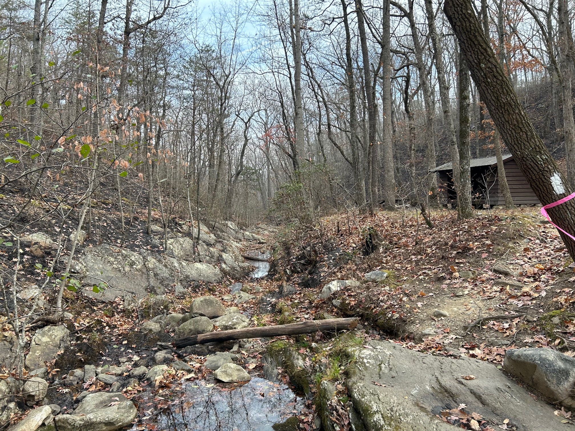
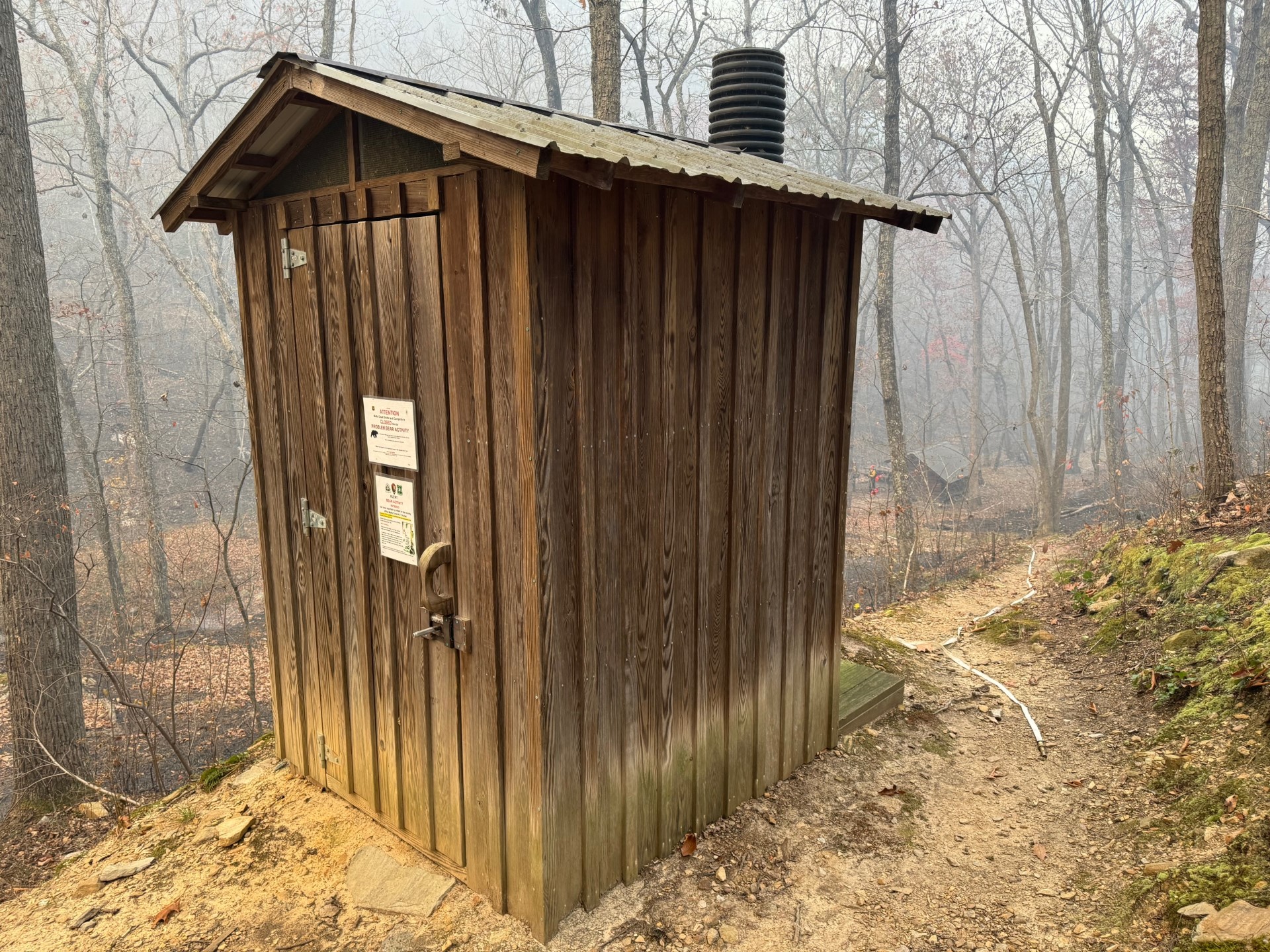
Matts Creek Shelter and Privy on the Appalachian National Scenic Trail Survives Matts Creek Fire
Related Incident:
Publication Type: News
During the early hours and days of the fire, firefighters used a combination of leaf blowers, hand tools, pump and hoses to successfully protect the shelter and surrounding area. Hand tools and leaf blowers were used to remove the leaf litter around the structures to create a defensible space area. Hoses were placed to wet down the whole area to keep the fire from getting too close while the fire approached.
When a wildfire isn't burning in the area, the Appalachian Trail is collaboratively managed under a partnership agreement with the Natural Bridge Appalachian Trail Club (NBATC) and Appalachian Trail Agreement. NBATC members maintain both the shelter and trail itself, mitigating hazards and ensuring a quality user experience for hikers of the Appalachian Trail.
This stretch of the Appalachian Trail is a very popular hiking destination for local and regional hikers as well as for thru-hikers. The Matts Creek Shelter was built in the early 1960s, along with many others on the 90-mile stretch of Appalachian Trail maintained by the NBATC, and is a piece of history we wanted to protect.
Matts Creek Fire Closures
Related Incident:
Publication Type: Closures
The James River Face Wilderness and all associated trails, including a section of Appalachian National Scenic Trail, are closed to all public use due to the on-going wildland fire.
The following areas are temporarily closed to allow for public and fire fighter safety:
- Locher Tract
- Glenwood Horse Trail (FT#3004) from the Blue Ridge Parkway to the Hellgate Trailhead
- Appalachian Trail (FT #1) from James River Foot Bridge to Petites Gap Road (FR #35)
- James River Foot Bridge Parking Lot
- Matts Creek Trail (FT #4/Old A.T.)
- Piney Ridge Trail (FT #2)
- Gunther Ridge Trail (FT #8)
- Belfast Trail (FT #9)
- Sulphur Springs Trail (FT# 3001)
Use caution and obey all road signs for your safety. Motorists should be alert for firefighter vehicles and smoke.
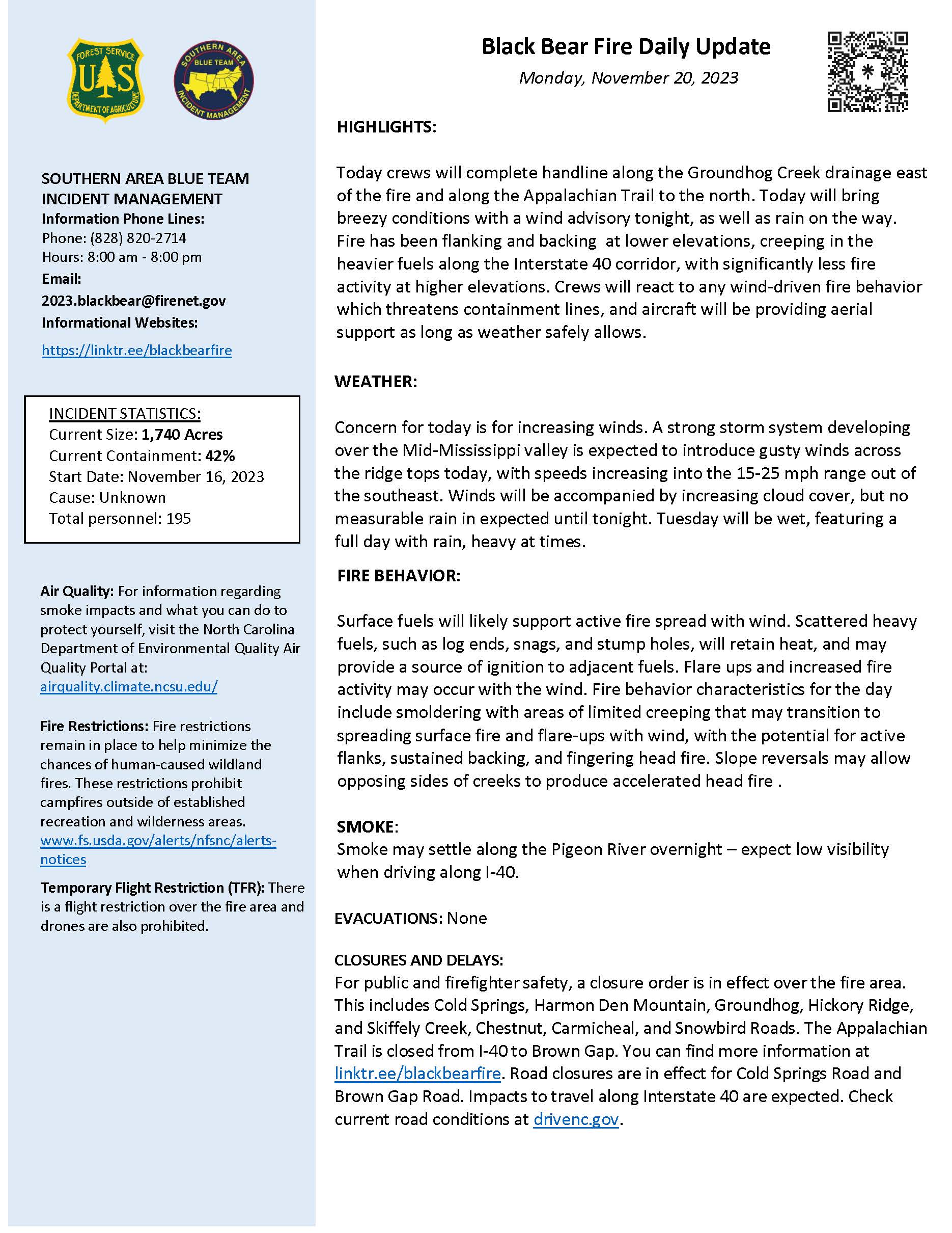
Daily Update Monday November 20 2023
Related Incident: 2023 Black Bear Fire
Publication Type: Announcement
Black Bear Fire
Daily Update – Monday, November 20, 2023
Southern Area Blue CIMT
1,740 acres | 42% containment | 195 personnel assigned
Highlights: Today crews will complete handline along the Groundhog Creek drainage east of the fire and along the Appalachian Trail to the north. Today will bring breezy conditions with a wind advisory tonight, as well as rain on the way. Fire has been flanking and backing at lower elevations, creeping in the heavier fuels along the Interstate 40 corridor, with significantly less fire activity at higher elevations. Crews will react to any wind-driven fire behavior which threatens containment lines, and aircraft will be providing aerial support as long as weather safely allows.
Facebook: https://www.facebook.com/nfsnc/
Weather: Concern for today is for increasing winds. A strong storm system developing over the Mid-Mississippi valley is expected to introduce gusty winds across the ridge tops today, with speeds increasing into the 15-25 mph range out of the southeast. Winds will be accompanied by increasing cloud cover, but no measurable rain in expected until tonight. Tuesday will be wet, featuring a full day with rain, heavy at times.
Fire Behavior: Surface fuels will likely support active fire spread with wind. Scattered heavy fuels, such as log ends, snags, and stump holes, will retain heat, and may provide a source of ignition to adjacent fuels. Flare ups and increased fire activity may occur with the wind. Fire behavior characteristics for the day include smoldering with areas of limited creeping that may transition to spreading surface fire and flare-ups with wind, with the potential for active flanks, sustained backing, and fingering head fire. Slope reversals may allow opposing sides of creeks to produce accelerated head fire.
Air Quality: Smoke may settle along the Pigeon River overnight – expect low visibility when driving along I-40. For information regarding smoke impacts and what you can do to protect yourself, visit the North Carolina Department of Environmental Quality Air Quality Portal at airquality.climate.ncsu.edu/.
Burn Bans: Fire restrictions remain in place to help minimize the chances of human-caused wildland fires. These restrictions prohibit campfires outside of established recreation and wilderness areas. www.fs.usda.gov/alerts/nfsnc/alerts-notices.
Temporary Flight Restriction (TFR): There is a flight restriction over the fire area and drones are also prohibited. If you fly, we can't!
Evacuations: None.
Closures: For public and firefighter safety, a closure order is in effect over the fire area. This includes Cold Springs, Harmon Den Mountain, Groundhog, Hickory Ridge, and Skiffely Creek, Chestnut, Carmicheal, and Snowbird Roads. The Appalachian Trail is closed from I-40 to Brown Gap. You can find more information at linktr.ee/blackbearfire. Road closures are in effect for Cold Springs Road and Brown Gap Road. Impacts to travel along Interstate 40 are expected. Check current road conditions at drivenc.gov.
Matts Creek Fire Update Nov 20 2023
Related Incident:
Publication Type: News
Acres: 10,106
Containment: 27%
Cause: undetermined
Start Date: Sunday, November 12, 2023
Total personnel: 317
Location: James River Face Wilderness and Blue Ridge Parkway
Fuels: Mixed hardwoods, shrubby vegetation, and leaf litter
Operations: Yesterday, firefighter conducted a strategic firing operation south of Glasgow, and east of Greenlee between the James River and Belfast Creek using a helicopter. Removing this fuel will provide added protection for surrounding communities, and the forest and will help firefighters prevent spread of the fire. This operation will decrease the risk of intense fire behavior and long-duration smoke. Crews took advantage of favorable conditions, and the operation was successful in producing a low intensity burn with no spot fires reported. A low intensity fire can decrease leaf litter, remove brush, moderate fire behavior and will cause little to no damage to the trees, similar to a prescribed fire. The strategic firing operation helped move the fire over the slopes and into flatter terrains. This will allow firefighters to engage the fire in a safer area and proved a greater chance to successfully stop the fire from spreading to the west.
In the northeastern portion of the fire, near Snowden, crews continued to improve fire lines and the area is looking very good and forward progression has stopped. Crews will search for and extinguish any “hot spots” in logs, stumps and under the ground.
In the southeastern portion of the fire near Big Island and Powells Store, fire activity was minimal. Firefighters patrolled the area and removed fire-damaged trees.
In the southwestern area fire lines have held well, increasing containment to 27 percent.
Firefighters continued to watch the Hercules Fire, a small fire that started yesterday across the James River. A local volunteer fire department had responded and contacted crews on the night shift for additional help. The fire was slightly under one acre in size. Crews will continue to monitor this fire throughout the day.
Today, firefighters will work within the strategic burn operation to locate and extinguish areas of heat and monitor the fire. Crews will also continue to improve existing fire containment lines and patrol the Blue Ridge Parkway for burning material rolling into the roadway. Firefighters continue to improve monitor handline to the James River. They will continue working to assess structures along Hunt Camp Road and along the western side of the fire and to develop a protection plan for the area if needed. The fire will be monitored overnight.
Personnel and equipment on the fire include 6 hand crews, 15 engines, 4 helicopters, 2 water tenders and 1 drone.
Weather and Fire Behavior
Today, temperatures are expected to be in the lower 50s with humidity between 40-60 percent. East winds will be between 5-10 miles per hour, turning east/southeast during the afternoon. Tonight will bring increased clouds and possibly some light winds after midnight. For Tuesday, rain is expected to remain steady and may possibly become heavier at times. Rainfall may be 1-2 inches and is anticipated to fall throughout the day. Winds will remain 5-10 mph with an occasional gust of up to 14 mph. Fire activity is expected to pick up later this afternoon. The strategic firing operation helped move the main fire front over slopes and into flatter areas. This will provide safer access to firefighters and allow a greater chance to successfully stop the fire from spreading to the west.
Smoke and Air Quality: Heavy smoke is likely in communities and along roadways near the fire area today. An incident air resource advisor issues smoke reports at https://outlooks.wildlandfiresmoke.net/outlook For more information on air quality visit AirNow.gov. Please use caution when driving in low-visibility areas.
Temporary Flight Restrictions: A Temporary Flight Restriction is in place around the fire area. Further information can be found at https://tfr.faa.gov/save_pages/detail_3_4016.html
Road Closures: Petites Gap Road (FSR35) is closed to all public use between the Belfast Trailhead and the Blue Ridge Parkway. This closure may be extended to the intersection of Arnold Valley Road (SR 781) and Back Run Road due to fire activity.
Blue Ridge Parkway Temporary Closure: The Blue Ridge Parkway is closed from milepost 66.3, near US Highway 501, to milepost 85.9, at VA Route 43 until further notice. Park visitors should plan for a detour from the north or south using adjacent routes and Interstate 81.
Closures: The James River Face Wilderness and all associated trails, including a section of Appalachian National Scenic Trail, are closed to all public use due to the on-going wildland fire.
The following areas are temporarily closed to allow for public and fire fighter safety:
- Locher Tract
- Glenwood Horse Trail (FT#3004) from the Blue Ridge Parkway to the Hellgate Trailhead
- Appalachian Trail (FT #1) from James River Foot Bridge to Petites Gap Road (FR #35)
- James River Foot Bridge Parking Lot
- Matts Creek Trail (FT #4/Old A.T.)
- Piney Ridge Trail (FT #2)
- Gunther Ridge Trail (FT #8)
- Belfast Trail (FT #9)
- Sulphur Springs Trail (FT# 3001)
Use caution and obey all road signs for your safety. Motorists should be alert for firefighter vehicles and smoke.
Fire Restrictions:
Stage 1 Fire Restrictions in effect: For the protection of public health and safety, the following acts are prohibited on all lands administered by George Washington & Jefferson National Forest.
1. Building, maintaining, attending, or using a fire or campfire outside of developed recreation sites.
2. Possessing, discharging, or using any kind of firework or other pyrotechnic device.
Campfires in a Forest Service provided metal fire pit, ring or grill at a developed recreation site are allowed.