
Daily Update Thursday November 16 2023
Related Incident: 2023 Collett Ridge Fire
Publication Type: Announcement
5,447 acres | 80% containment | 232 personnel assigned
Highlights: Isolated sources of heat flared up yesterday along the northwest flank of the fire as fuels continued to dry out, with fire creeping downslope through forest floor fuels, producing visible flames and an increased volume of smoke. As a result, firefighters conducted tactical firing operations along the containment lines on McClelland Creek Road and Snider Road, removing available fuels from the fire and providing additional security for area residences. Fuel reduction activities will continue around residences in the area, and aerial resources will continue to conduct water drops as needed.
Facebook: https://www.facebook.com/nfsnc/
Resources assigned to the fire include two 20-person handcrews, 8 Engines, and 1 dozer. Aerial resources include two helicopters.
Weather & Fire Behavior: High pressure over the region will maintain fair weather but with variable amounts of cloud cover. Dewpoints are on the increase so the relative humidity minimums will be higher today compared to yesterday. A few sprinkles can’t be ruled out but the chance for measurable rainfall is very low. Temperatures are forecast to be warmer with highs in the 60s with gusty winds along the ridges.
Surface fuels have become dry enough to support conditional fire spread where a heat source is present. Until sufficient precipitation occurs, expect areas of isolated smoldering, primarily in heavy woody fuels, such as log ends, snags, and stumps. Heavy fuel concentrations will retain heat and serve as future heat sources. The primary fire behavior characteristic for the day continues to be isolated smoldering. Smoldering leaf litter may kindle to flame with a little wind and/or sunshine, and burning snags may fall into fresh fuels, such as newly fallen leaves.
Air Quality: Smoke will be present for the next few days until the inversion layer lifts or an increase in moisture occurs, with air quality expected to be between Moderate and Unhealthy for Sensitive Groups. Air quality information provided by the North Carolina Department of Environmental Quality is available at airquality.climate.ncsu.edu/.
Burn Bans: Due to increased fire risk, the N.C. Forest Service has issued a ban on all open burning until further notice in several counties in western North Carolina. For more information visit https://www.ncforestservice.gov/fire_control/sit_report.htm
The U.S. Forest Service has implemented fire restrictions across the Pisgah and Nantahala National Forests. To view the closure order visit www.fs.usda.gov/alerts/nfsnc/alerts-notices
Temporary Flight Restriction: A Temporary Flight Restriction (TFR) is in place over the Collett Ridge Fire area. If you fly, we can’t. Aircraft or drone intrusions into the restricted airspace endangers aircrews conducting fire operations and aerial resources are grounded for safety. This unnecessarily places aircrews and ground fire crews at risk in a dynamic and dangerous fire environment.
Closures: For public and firefighter safety the following road and area closures are in effect due to increased fire activity and suppression operations in the area from Big Stamp east to Shinbone Ridge to Signal Bald and a road closure is in effect from the intersection of Little Fires Creek Road, 340B, and Fires Creek Road, 340. The Rim Trail is temporarily closed for approximately 7 miles from Big Stamp to Shinbone.
Steep Valley Fire November 16th 2023 Update
Related Incident:
Publication Type: News
GLEN JEAN, WV - The Steep Valley Fire is currently 2,206 acres and containment remains at 78% as of Wednesday, November 15th, 2023. The fire continues to burn in steep and rugged parts of inaccessible terrain in the War Ridge and Backus Mountain areas, a remote part of the park. The cause of the fire is under investigation. Minimal fire activity Wednesday produced pockets of smoke within the gorge. With minimal fire activity, air quality levels are forecast to be in the good and moderate range.
Today, crews will monitor existing fire lines as the fire is expected to remain minimally active. Firefighters continued to make tactical decisions that included strategic firing to burn out pockets of fuel to help strengthen existing lines. “We appreciate all the dedicated crews and the countless hours they have put in while working the fire. We will continue to monitor the fire and focus on firefighter safety,” said Nate Orsburn, Incident Commander Trainee for the Steep Valley Fire. Orsburn continued, “We would like to thank the community for their hospitality, support, and patience since the beginning of this challenging fire, it hasn’t gone unnoticed.” To date, there has been one minor injury to a firefighter.
A UAS, or drone, was spotted in the fire area earlier this week. A Temporary Flight Restriction (TFR) is currently in effect for 5,000 feet above ground level and a 5-mile radius around the fire area. Any drone incursions into the Steep Valley Fire TFR area are a violation of FAA regulations. Additionally, all aircraft supporting firefighter operations would temporarily be grounded as drones endanger air crews that are flying. This interruption in firefighting support could put firefighters at extreme risk and could result in grave consequences for those actively engaged in fire suppression. Remember, If You Fly, We Can’t. As a reminder, launching, landing, or operating a drone within National Park Service lands is strictly forbidden.
A closure order remains in place for all National Park Service lands bounded by the New River on the south and west to the town of Quinnimont, due east along State Highway 41 to the intersection of Backus-Red Spring road, then continues directly south to the CSX railroad right of way at the river. The remainder of the park is open for normal hours of operation.
Resources from multiple federal and state agencies from across the country along with a private crew from Oregon are actively assisting fire personnel.
Quaker Run Fire Daily Update for Thursday November 16 2023
Related Incident:
Publication Type: News
Contact Information
- Email: 2023_QuakerRun@firenet.gov
- Phone: (540) 613-1809 (8 a.m.– 8 p.m.)
- Facebook: https://www.facebook.com/shenandoahNPS
- InciWeb: https://inciweb.wildfire.gov/vavas-2023-quaker-run-fire
Statistics
- Acres: 3,937
- Containment: 83%
- Location: 970 Quaker Run Road, Syria, VA 22727
- Date of Origin: October 24, 2023
- Cause: Undetermined
- Structures Damaged/Destroyed: 0
- Crews: 1
- Helicopters: 0*
- Engines: 1
- Dozers: 0
- Personnel: 134
- *If needed, a helicopter can be ordered from Virginia dispatch
Fire Activity
Yesterday, firefighters under the command of the Gold Team repaired trails within the park, including trails to Camp Hoover; removed pumps and hoses at Camp Hoover, also known as the Historic Rapidan Camp—National Park Service; and assisted National Park Service trail crews. They also monitored and patrolled the perimeter of the entire fire seeking new hotspots.
Today, many firefighters will leave the Quaker Run Fire and travel to other fires that need additional resources. The remaining crews and engines will monitor and patrol the uncontained section of the fire’s perimeter. They will also repair trails, roads and other areas as needed.
At 8 p.m. tonight, the Southern Area Gold Incident Management Team will transfer command to a Type 3 team. After that time, the phone number for fire information will be 540-999-3500 ext. 3183 and the email will be claire_comer@NPS.gov.
Incident Commander Debbie Beard thanks all the firefighters and team members who successfully worked on the fire. Please see her letter to the community on the last page of this update.
For information about fire management activities on private lands, follow www.facebook.com/ForestryVA. For information about fire management activities on NPS lands, follow www.facebook.com/shenanadoahNPS.
Weather
Critically low humidity is forecast today, even in the morning when very poor moisture recovery is forecast. This will be paired with sunny skies throughout the day. Winds will be south-southeast around 5-10 mph in the fire area. Temperatures will be in the low to mid-60s. Cloud cover will increase overnight. Humidities will rise rapidly to 80%. Temperatures will drop into the 40s.
Fire Behavior
Relative humidity levels are expected to be low today! Fine fuels will be very receptive to fire spread, especially in the mid-afternoon on a south or west facing slope. The risk of reburn inside the footprint today is high—multiple areas of reburn could occur simultaneously in the afternoon. Reburn intensity would be low, but potentially persistent. Isolated smokes could be visible across the fire footprint today. North and east facing slopes are still damp and may not carry fire, but south-facing slopes could readily support fire spread. In an uphill run, the intensity could be high.
Fire Bans
- Madison County has issued a county-wide burn ban. Outdoor burning is prohibited on all private and public land. Violations are punishable as a Class 3 misdemeanor as well as potential responsibility for the full amount of all expenses incurred in suppressing such fire. For more information, visit https://www.madisonco.virginia.gov/AlertCenter.aspx.
- Shenandoah National Park has implemented a complete fire ban. Building, attending, maintaining or using an open fire anywhere within the boundaries of the park is prohibited. This ban includes all wood, charcoal, coal or other solid-fuel open air fires and fires in grates, grills, rings or pits in campgrounds, picnic areas, shelters and huts. For more information, visit https://www.nps.gov/shen/planyourvisit/quaker-run-fire-information.htm.
Evacuations
Voluntary evacuations remain in place for Finks Hollow Road, north of Route 681.
Smoke
Air quality is currently good. Yesterday, smoke from other wildfires came into the area. Additional information is available at https://outlooks.airfire.org/outlook/dc5a2d56?
Closures
Shenandoah National Park
The Harry S. Byrd, Sr. Visitor’s Center remains open. The center was scheduled to close due to a power outage for firefighter safety. The power was restored prior to the scheduled closing. For hours and additional information, please visit https://www.nps.gov/shen/planyourvisit/visitorcenters.htm.
The following closures remain in effect in Shenandoah National Park:
- Rapidan Camp (also known as Historic Camp Hoover) area near the eastern boundary in the center of the park. The closure includes the area around the historic camp and the trails leading to it including the following:
- Mill Prong Trail
- Mill Prong Horse Trail
- Stony Mountain Trail
- Fork Mountain Trail
- Laurel Prong from Cat Knob intersection
- Upper Dark Hollow Trail (does NOT impact access to falls)
- The lower Rapidan Fire Road beyond the portion open to bicycles
- Graves Mill Trail from the intersection of the Staunton River Trail to the Rapidan Fire Road
- Wilhite Wagon Trail
Rapidan Wildlife Management Area – Rapidan Tract
Due to wildfire activity in the area, the Rapidan Tract of Rapidan Wildlife Management Area is temporarily closed in the interest of public safety. In addition, per Code of Virginia § 29.1-521, it is illegal “to kill or capture any wild bird or wild animal adjacent to any area while a field or forest fire is in progress.”
Temporary Flight Restrictions
The temporary flight restriction over the Quaker Run Fire has been lifted.
Donations
If you are considering donating to the Quaker Run Fire firefighting efforts, please take them to the Madison County Department of Emergency Medical Services at 1494 N. Main Street, Madison, VA 22727. Thank you.
![]()
Southern Area Gold Complex Incident Management Team
November 16, 2023
To the communities surrounding the Quaker Run Fire:
On behalf of all the firefighters and Gold Team members who worked on the Quaker Run Fire, we thank you for the support you have given us during the last two weeks.
We know this has been an incredibly stressful time for everyone in the community, yet you have dedicated your time and energy to help everyone work on this fire. Church members provided meals to firefighters, people greeted us with smiles and Southern hospitality wherever we went, and throughout it all we have felt welcome, supported and appreciated.
As a team, we travel around the country—sometimes around the world—to manage and fight wildfires. From the minute we arrive, our goal is to protect lives, homes and communities. In fact, we often say, “It’s our job to work ourselves out of a job.” You have made our job so much easier and have treated us with respect and humility. That’s why so many of us are proud to call the South our home.
At the end of this assignment, our team members will go their separate ways. As we say our goodbyes, many of us will say, “See you on the next one”, but there are those few special experiences that we hold close in our hearts for years to come. This incident, and the kindness you have shown us, will certainly be one we remember with fondness.
Again, thank you for everything.
Sincerely,
Debbie Beard Paul Varnedoe
Incident Commander Incident Commander, Trainee
Before Wrapping up Prescribed Fire Crews Treat 500 Acres and Respond to Small Wildfire
Related Incident:
Publication Type: News
Nov. 15, 2023—Fire crews today completed an additional 500 acres of treatment on Alamosa Unit 1, wrapping up ignitions on the project for the time being. Weather and conditions, particularly ventilation of on-site smoke, continue to fluctuate, often in a manner not conducive to prescribed fire.
Fire managers will continue to look for opportunities to finish treating the unit in the future. 3,250 acres of the 4,500-acre unit were treated over the last week.
“I’m really proud of our team for their progress,” said District Ranger Angie Krall. “Their work reduces the risk of wildfire to Vallecitos and brings many other benefits to the landscape and forest community members.”
Alamosa Unit 1 is directly adjacent to the southwest end of the Rio Arriba County community of Vallecitos. It’s bounded by Forest Roads 44, 44K and 725.
The prescribed fire will likely continue to smolder, creep and back within the unit in upcoming days and may produce some smoke. Carson National Forest crew members will continue to patrol and monitor the fire until it is called out. Other resources who traveled to assist on the project will demobilize and return to their home units.
Alamosa Unit 1 is within the Rio Chama Collaborative Forest Landscape Restoration Project, which covers 3.8 million acres in Northern New Mexico and Southern Colorado. It aims to improve the health of the Rio Chama and Rio Grande watersheds, among many other goals.
Crews Respond to Small Nearby Wildfire
During ignitions, crew members noticed light smoke coming from the northwest of Alamosa Unit 1. An engine crew assigned to the prescribed fire responded and found an estimated one-acre human-caused wildfire in mostly mixed conifer near Posos Spring. They fully contained it at 4:49 p.m. The fire’s cause is under investigation.
November 16 2023 Pile Burning Update
Related Incident: Lolo National Forest Prescribed Fire Operations
Publication Type: Announcement
Pending conditions, pile burning efforts will continue today on the Plains/Thompson Falls and Superior Districts to reduce hazardous fuels from previous vegetation management operations.
Plains/Thompson Falls Ranger District: The Plains/Thompson Falls District will conduct pile burning 7 miles southwest of Plains. Smoke may be visible from Plains.
Superior Ranger District: Firefighters will initiate up to 20 acres of pile burning operations located 8 miles southeast of Superior. Smoke may be visible from Superior and Interstate 90.
Change of Weather Prompts Ignitions Today
Related Incident:
Publication Type: News
Nov. 15, 2023—Due to a change in weather and conditions, including improved ventilation, fire crews are planning to pivot from only patrolling and monitoring to additionally conducting ignitions. If a test fire is successful, up to 500 acres may be treated with prescribed fire later today.
It is unlikely ignitions will continue Thursday.
Steep Valley Fire November 15th 2023 Update
Related Incident:
Publication Type: News
GLEN JEAN, WV - The Steep Valley Fire is currently 2,182 acres and containment is up to 78% as of Tuesday, November 14th, 2023. The fire continues to burn in steep and rugged parts of inaccessible terrain in the War Ridge and Backus Mountain areas, a remote part of the park. The cause of the fire is under investigation.
Fire activity increased on Tuesday which produced pockets of smoke in the fire area. However, upon reaching the established containment lines, activity was significantly reduced. Pockets of smoke accompanied the increased fire activity and could linger in the area for a few days. With minimal fire activity, air quality levels are forecast to be in the good and moderate range.
Today, crews will improve existing fire lines as the fire is expected to remain minimally active. Yesterday during suppression efforts, firefighters made tactical decisions that included strategic firing to burn out pockets of fuel to help strengthen existing lines. Firefighter safety remains a number one priority. To date, there has been one minor injury to a firefighter.
A UAS, or drone, was spotted in the fire area earlier this week. A Temporary Flight Restriction (TFR) is currently in effect for 5,000 feet above ground level and a 5-mile radius around the fire area. Any drone incursions into the Steep Valley Fire TFR area are a violation of FAA regulations. Additionally, all aircraft supporting firefighter operations would temporarily be grounded as drones endanger air crews that are flying. This interruption in firefighting support could put firefighters at extreme risk and could result in grave consequences for those actively engaged in fire suppression. Remember, If You Fly, We Can’t. As a reminder, launching, landing, or operating a drone within National Park Service lands is strictly forbidden.
A closure order remains in place for all National Park Service lands bounded by the New River on the south and west to the town of Quinnimont, due east along State Highway 41 to the intersection of Backus-Red Spring Road, then continues directly south to the CSX railroad right of way at the river. The remainder of the park is open for normal hours of operation. Should conditions change, park management will reassess for any needs to adjust park operations.
Resources from multiple federal and state agencies from across the country along with a private crew from Oregon have arrived to assist fire personnel.
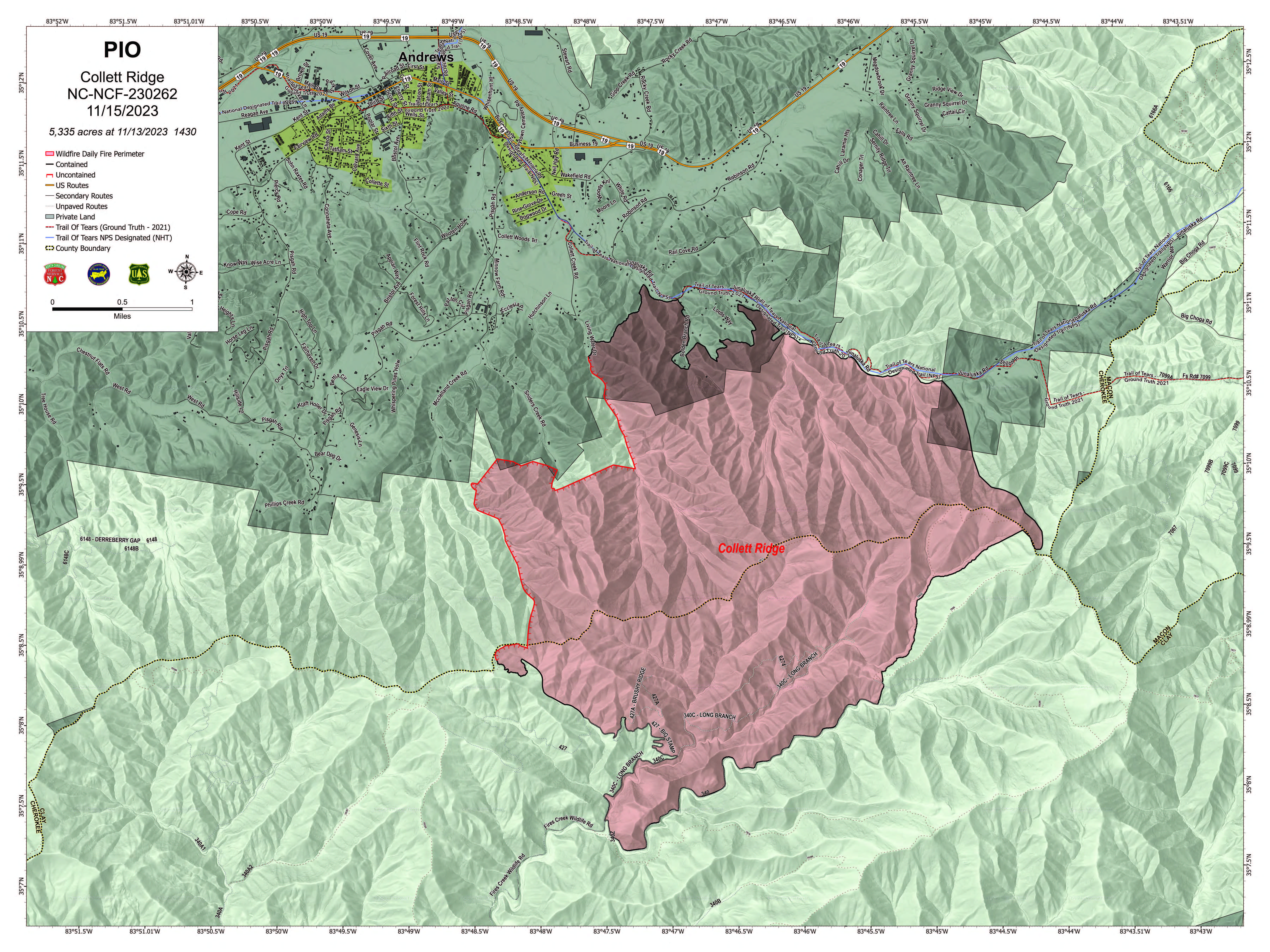
Daily Update Wednesday November 15 2023
Related Incident: 2023 Collett Ridge Fire
Publication Type: Announcement
5,335 acres | 79% containment | 268 personnel assigned
Highlights: Firefighters continue to perform mop-up operations, extinguishing any lingering hotspots, as needed. Crews hold and improve containment and completed fireline. Fire activity is minimal; however, some visible smoke may be present in the area where the fire is most active in the northwest perimeter near Rattlesnake Knob.
Fuel reduction activities are being performed around residences in the area of the Snowbird Wilderness Outfitters as a protection measure, with plans to continue fuel reduction work around residences located south of Pisgah Road to the McClelland Creek Road and Snider Road area, and along the south side of Junaluska Road towards Junaluska Baptist Church. Aerial resources continue to conduct flights to monitor for changing fire conditions and are ready to respond if needed.
Facebook: https://www.facebook.com/nfsnc/
Resources assigned to the fire include four 20-person handcrews, 19 Engines 2 dozers, and 1 water tenders. Aerial resources include two helicopters.
Weather & Fire Behavior: Overcast conditions are expected today as a storm system passes to our south. Although there is a slight chance of light rain throughout the day, overall humidity will be under 30%. Cloud cover will keep high temperatures mainly in the 50s with southeasterly winds at 5 to 15 mph.
Where a heat source is present, surface fuels have become dry enough to allow limited fire spread. The primary fire behavior characteristic continues to be isolated smoldering. Smoldering leaf litter may kindle to flame with a little wind and/or sunshine, and burning snags may fall into fresh fuels, such as newly fallen leaves. Heavy fuel concentrations will retain heat and serve as future heat sources. Areas of isolated smoldering, primarily in heavy woody fuels, such as log ends and snags will continue until a season-ending rain event occurs.
Air Quality: Smoke may occur in nearby communities. Air quality information provided by the North Carolina Department of Environmental Quality is available at airquality.climate.ncsu.edu/.
Burn Bans: Due to increased fire risk, the N.C. Forest Service has issued a ban on all open burning until further notice in several counties in western North Carolina. For more information visit https://www.ncforestservice.gov/fire_control/sit_report.htm.
The U.S. Forest Service has implemented fire restrictions across the Pisgah and Nantahala National Forests. To view the closure order visit www.fs.usda.gov/alerts/nfsnc/alerts-notices.
Temporary Flight Restriction: A Temporary Flight Restriction (TFR) is in place over the Collett Ridge Fire area. If you fly, we can’t. Aircraft or drone intrusions into the restricted airspace endangers aircrews conducting fire operations and aerial resources are grounded for safety. This unnecessarily places aircrews and ground fire crews at risk in a dynamic and dangerous fire environment.
Closures: For public and firefighter safety the following road and area closures are in effect due to increased fire activity and suppression operations in the area from Big Stamp east to Shinbone Ridge to Signal Bald and a road closure is in effect from the intersection of Little Fires Creek Road, 340B, and Fires Creek Road, 340. The Rim Trail is temporarily closed for approximately 7 miles from Big Stamp to Shinbone.
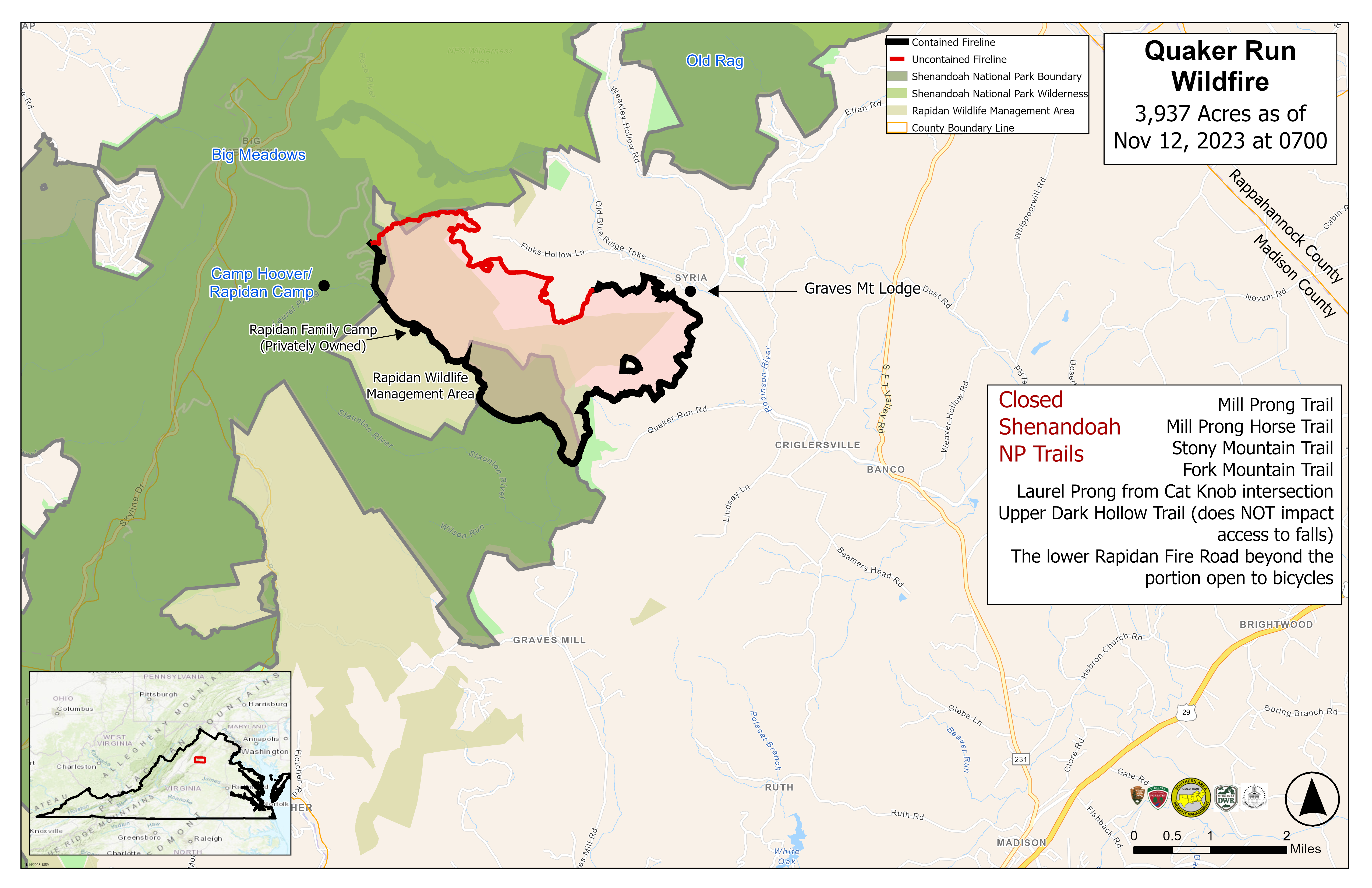
Quaker Run Fire Daily Update for Wednesday November 15 2023
Related Incident:
Publication Type: News
Contact Information
- Email: 2023_QuakerRun@firenet.gov
- Phone: (540) 613-1809 (8 a.m.– 8 p.m.)
- Facebook: https://www.facebook.com/shenandoahNPS
- InciWeb: https://inciweb.wildfire.gov/vavas-2023-quaker-run-fire
Statistics
- Acres: 3,937
- Containment: 61%
- Location: 970 Quaker Run Road, Syria, VA 22727
- Date of Origin: October 24, 2023
- Cause: Undetermined
- Structures Damaged/Destroyed: 0
- Crews: 6
- Helicopters: 1
- Engines: 4
- Dozers: 1
- Personnel: 160
Fire Activity
Thanks to the excellent work done by firefighters over the last few days, containment lines around the fire held during the day yesterday. A small area in the fire’s eastern section experienced reburn, which firefighters were able to put out quickly (approximately 0.25 acre located about 200 yards inside the containment line). Crews also blew leaves off the entire eastern containment line to ensure no additional reburn would occur. A helicopter did a reconnaissance flight across the fire and saw only one smoke, which was at least 350 yards inside the containment line. Firefighters dismantled pumps and hoses at Camp Hoover, also known as the Historic Rapidan Camp—National Park Service, which is no longer threatened.
As of 8 p.m. last night, the Quaker Run Fire is no longer in unified command. The Southern Area Gold Complex Incident Management Team continues to manage the fire on lands within the Shenandoah National Park. The Virginia Department of Forestry continues to manage the fire on private lands.
Today, firefighters under the command of the Gold Team will repair trails within the park, including trails to Camp Hoover; remove pumps and hoses at Camp Hoover; and assist National Park Service trail crews as needed. They also will continue to monitor and patrol containment lines.
For information about fire management activities on private lands, follow www.facebook.com/ForestryVA. For information about fire management activities on National Park Service lands, follow www.facebook.com/shenanadoahNPS
Weather
Today will be mostly cloudy with humidity this morning around 80%, dropping to about 40% this afternoon. High temperatures will be in the mid- to upper 50s with southwest winds at 5-10 mph with occasional gusts up to 14 mph in the afternoon and along the ridges.
Fire Behavior
Clouds and somewhat higher humidity will keep fine fuel moistures slightly higher today as compared to yesterday. Fuels will not be quite as volatile. Reburn activity is still possible, but overall should be less than yesterday. Isolated smokes will likely remain visible across the fire footprint. Smoldering, creeping or ground fire is also possible.
Fire Bans
- Madison County has issued a county-wide burn ban. Outdoor burning is prohibited on all private and public land. Violations are punishable as a Class 3 misdemeanor as well as potential responsibility for the full amount of all expenses incurred in suppressing such fire. For more information, visit https://www.madisonco.virginia.gov/AlertCenter.aspx.
- Shenandoah National Park has implemented a complete fire ban. Building, attending, maintaining or using an open fire anywhere within the boundaries of the park is prohibited. This ban includes all wood, charcoal, coal or other solid-fuel open air fires and fires in grates, grills, rings or pits in campgrounds, picnic areas, shelters and huts. For more information, visit https://www.nps.gov/shen/planyourvisit/quaker-run-fire-information.htm.
Evacuations
Voluntary evacuations remain in place for Finks Hollow Road, north of Route 681.
Smoke
Air quality is currently good. Additional information is available at https://outlooks.airfire.org/outlook/dc5a2d56?
Closures
Shenandoah National Park
The Harry S. Byrd, Sr. Visitor’s Center remains open. The center was scheduled to close due to a power outage for firefighter safety. The power was restored prior to the scheduled closing. For hours and additional information, please visit https://www.nps.gov/shen/planyourvisit/visitorcenters.htm.
The following closuresremain in effect in ShenandoahNational Park:
- Rapidan Camp (also known as Historic Camp Hoover) area near the eastern boundary in the center of the park. The closure includes the area around the historic camp and the trails leading to it including the following:
- Mill Prong Trail
- Mill Prong Horse Trail
- Stony Mountain Trail
- Fork Mountain Trail
- Laurel Prong from Cat Knob intersection
- Upper Dark Hollow Trail (does NOT impact access to falls)
- The lower Rapidan Fire Road beyond the portion open to bicycles
- Graves Mill Trail from the intersection of the Staunton River Trail to the Rapidan Fire Road
- Wilhite Wagon Trail
Rapidan Wildlife Management Area – Rapidan Tract
Due to wildfire activity in the area, the Rapidan Tract of Rapidan Wildlife Management Area is temporarily closed in the interest of public safety. In addition, per Code of Virginia § 29.1-521, it is illegal “to kill or capture any wild bird or wild animal adjacent to any area while a field or forest fire is in progress.”
Temporary Flight Restrictions
A temporary flight restriction is in place over the Quaker Run Fire area from the surface up to and including 6,500 feet to provide a safe environment for firefighting. For more information, visit: https://tfr.faa.gov/save_pages/detail_3_7678.html.
Donations
If you are considering donating to the Quaker Run Fire firefighting efforts, please take them to the Madison County Department of Emergency Medical Services at 1494 N. Main Street, Madison, VA 22727. Thank you.
More Ignitions Tentatively Planned for Thursday
Related Incident:
Publication Type: News
Nov. 14, 2023—Fire crews are potentially planning to continue ignitions on Thursday, Nov. 16, when current weather and conditions, particularly the ventilation rate, are forecasted to improve. Crews have remained on scene the past two days monitoring and patrolling the fire, which has grown 150 acres since Sunday evening as it creeps and backs along the forest floor. The fire will continue to produce smoke that may be visible at times.
A limited number of portable HEPA air filters purifiers are still available for loan at the El Rito Ranger Station. Call (575) 581-4554 to reserve one before picking up.
A total of 2,750 acres of the 4,500-acre unit has been treated so far.