
Trail Springs and Mill Creek 2 Fire Update November 12 2023
Related Incident: Trail Springs FireMill Creek 2 Fire
Publication Type: News
Update: November 12, 2023
Type 4, Incident Commander Shane McCracken, 21 Personnel
The fire danger level is currently HIGH. It is important that forest users completely drown campfires to prevent unintended escape. Use the “drown, stir, feel” method to be sure it's dead out.
Trail Springs Fire | Size: 1303 Acres | Containment: 43% | Cause: Lightning
The fire is located 12 miles northwest of Pagosa Springs on Forest land to the east of West Devil Creek. A helicopter reconnaissance flight on Saturday showed minimal fire activity. The fire continues to burn through ground fuels and dead and down wood, within defined management boundaries. There has not been significant growth in recent days and the fire has not crossed to the other side of West Devil Creek. With containment line established to protect values to the east, firefighters will continue to closely watch fire activity and take more fire control measures, if necessary. They also remain ready to respond should any new fires start in the Pagosa Ranger District.
Mill Creek 2 Fire |
Size: 146 Acres | Containment: 0% | Cause: Human
This fire is located in rugged, remote terrain near the border of the South San Juan Wilderness Area northeast of Pagosa Springs. Aerial observations on Saturday showed increased activity, as the fire continues to creep through pockets of fuel. No homes, ranches or other significant values are at risk. Fire managers expect that smoke will continue to be visible until the area gets a significant precipitation event, and may get heavy again if windy conditions return.
Weather: A high pressure system over the fire areas means continued dry conditions with little cloud cover for the early part of the week. High temperatures will be in the mid 50’s Sunday and Monday with light winds out of the north in the morning, shifting to southerly in the afternoon. Overnight lows temps will be in the upper 20’s. There is an increased chance of precipitation later in the week.
San Juan NF Temporary Closures: An area closure is in place involving roads and trails in or near the Trail Springs Fire area (Middle Mountain area). Details of the closure are on the Trail Springs Fire InciWeb page (QR code below) and on the “Alerts and Notices” page of the forest website: https://www.fs.usda.gov/alerts/sanjuan/alerts-notices
Fire Information: 970-426-5370 (8 a.m. to 8 p.m.) | Facebook: https://www.facebook.com/sanjuannationalforest
Daily Update Sunday November 12 2023
Related Incident: 2023 Collett Ridge Fire
Publication Type: Announcement
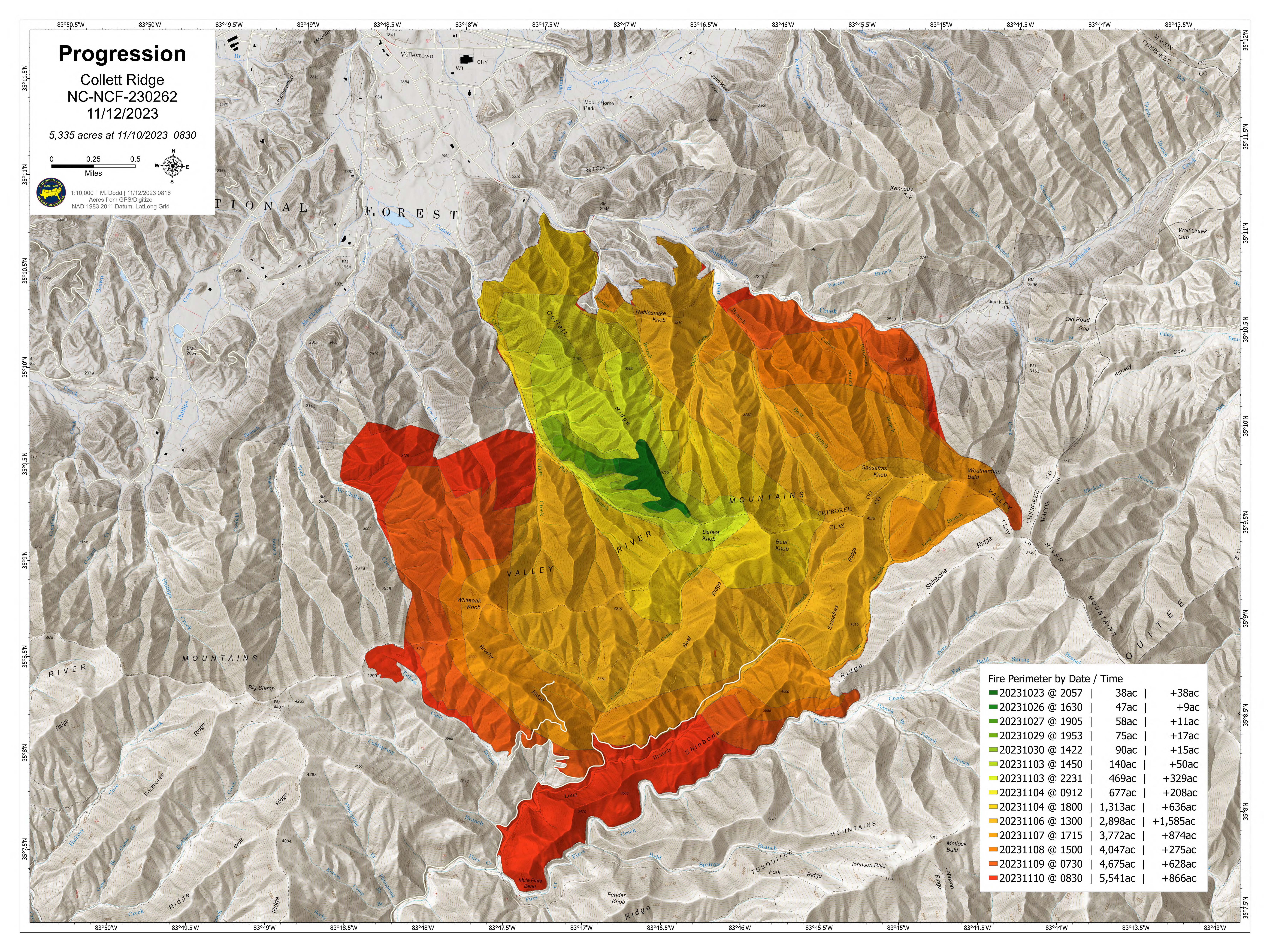
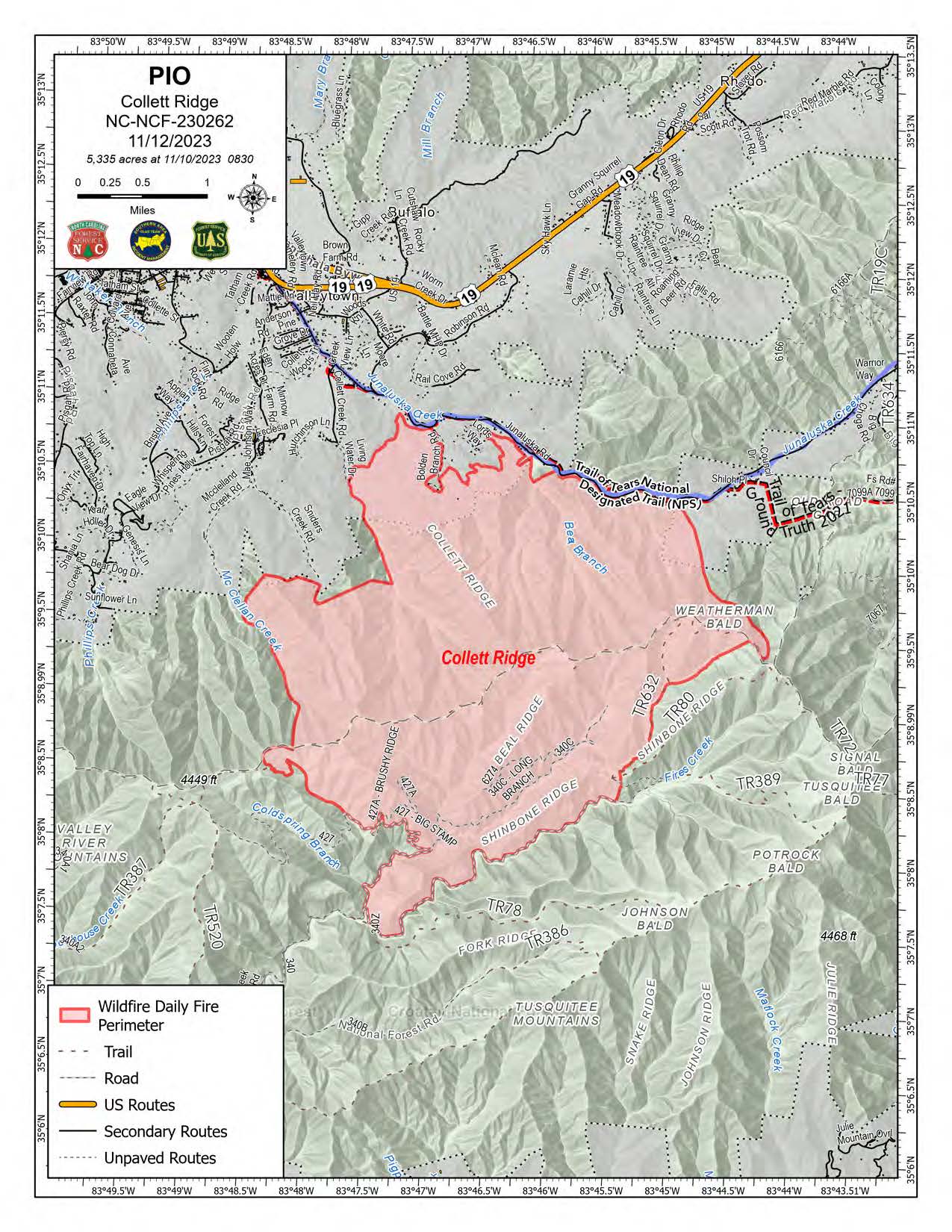
5,335 acres | 18% containment | 263 personnel assigned
Highlights: Fire behavior was minimal again yesterday thanks to the continued cloud cover, cooler temperatures, increased humidity, and precipitation; today’s forecast calls for these conditions to continue through the morning with gradual clearing this afternoon.
Crews completed the hand line between Snider’s Creek Road and McClelland Creek Road yesterday connecting it with the dozer line along the western side of the fire. Construction of hand line will continue from the dozer line south along Polecat Branch to connect in with Forest Road 427 along the southern edge of the fire. Firefighters will begin thinning fire fuels around residences in the Phillips Creek Road and Pisgah Road area as a protection measure from future fires.
Along the northern edge of the fire, crews will continue to patrol near the communities of Bolden Branch, Lord’s Way, and the Kimsey Cove area and perform mop-up operations, such as extinguishing any lingering hotspots, as needed. Fire activity along the southern edge of the fire has been minimal, and crews will patrol the area and perform mop-up operations.
Facebook: https://www.facebook.com/nfsnc/
Resources assigned to the fire includes, five 20-person hand crews, Type 4 and 6 Engines; Dozers; and Water Tenders. Aerial resources include three helicopters.
Weather & Fire Behavior: Any residual light rain or drizzle this morning is expected to diminish today with partial clearing this afternoon. High pressure is forecast to move into the area from the north today into Monday with a period of slow drying the next two to three days. Temperatures will be near, or just below, the seasonal normal for this time of year with highs in the 50s. Winds will be very light.
Until sufficient precipitation occurs on the fire, expect areas of smoldering and isolated creeping. Forest floor leaf litter may continue to burn even with the high relative humidity. Heavy fuel concentrations will retain heat and serve as future heat sources. Primary fire behavior characteristic for the day continues to be limited smoldering and creeping. With a little wind and/or sunshine, small flames may resume in leaf litter.
Air Quality: Smoke may occur in nearby communities. Air quality information provided by the North Carolina Department of Environmental Quality is available at airquality.climate.ncsu.edu/.
Burn Bans: Due to increased fire risk, the N.C. Forest Service has issued a ban on all open burning until further notice in several counties in western North Carolina. For more information visit https://www.ncforestservice.gov/fire_control/sit_report.htm.
The U.S. Forest Service has implemented fire restrictions across the Pisgah and Nantahala National Forests. To view the closure order visit www.fs.usda.gov/alerts/nfsnc/alerts-notices.
Temporary Flight Restriction: A Temporary Flight Restriction (TFR) is in place over the Collett Ridge Fire area. If you fly, we can’t. Aircraft or drone intrusions into the restricted airspace endangers aircrews conducting fire operations and aerial resources are grounded for safety. This unnecessarily places aircrews and ground fire crews at risk in a dynamic and dangerous fire environment.
Closures: For public and firefighter safety the following road and area closures are in effect due to increased fire activity and suppression operations in the area from Big Stamp east to Shinbone Ridge to Signal Bald and a road closure is in effect from the intersection of Little Fires Creek Road, 340B, and Fires Creek Road, 340. The Rim Trail is temporarily closed for approximately 7 miles from Big Stamp to Shinbone.
Steep Valley Fire November 12th 2023 Update
Related Incident:
Publication Type: News
GLEN JEAN, WV - The Steep Valley Fire increased to 1946 acres as of Saturday, November 12th, 2023. Although minimal fire activity was seen Saturday, the increase in acreage is due to updated imaging and mapping. The fire continues to burn in the War Ridge and Backus Mountain areas, a remote part of the park and remains within park boundaries. Containment is now up to 50% as of Saturday evening. Smoke may be visible when the fire is actively burning, and it may linger in the gorge for several days as it moves across the landscape. The cause of the fire is under investigation.
While the rain on Friday diminished fire activity, the fire is not out. The weather outlook shows a drying trend settling into the area starting today which will likely lead to an increase in fire activity. When the fire reanimates, firefighters who are actively engaging in suppression make tactical decisions which may include burning out pockets of fuels to help strengthen existing lines. With any increase in fire activity, smoke will be present within the gorge and will likely linger for a few days. Air quality in the New River Gorge area is currently listed as good and will be monitored in the coming days.
As of Saturday, 62 firefighters were actively engaged on the fire. Today, crews will reinforce and maintain fire lines as a warming and drying trend is expected for the area. Firefighter safety remains our number one priority. To date, there has been one minor injury to a firefighter.
The War Ridge Campground and access road are the only closures in the park. The remainder of the park is open for normal hours of operation. Should fire activity and conditions change, park management will reassess for any needs to adjust park operations.
Resources from multiple federal and state agencies from across the country along with a private hand crew from Oregon have arrived to assist New River Gorge National Park and Preserve personnel.
Quaker Run Fire Daily Update for Sunday November 12 2023
Related Incident:
Publication Type: News
Statistics
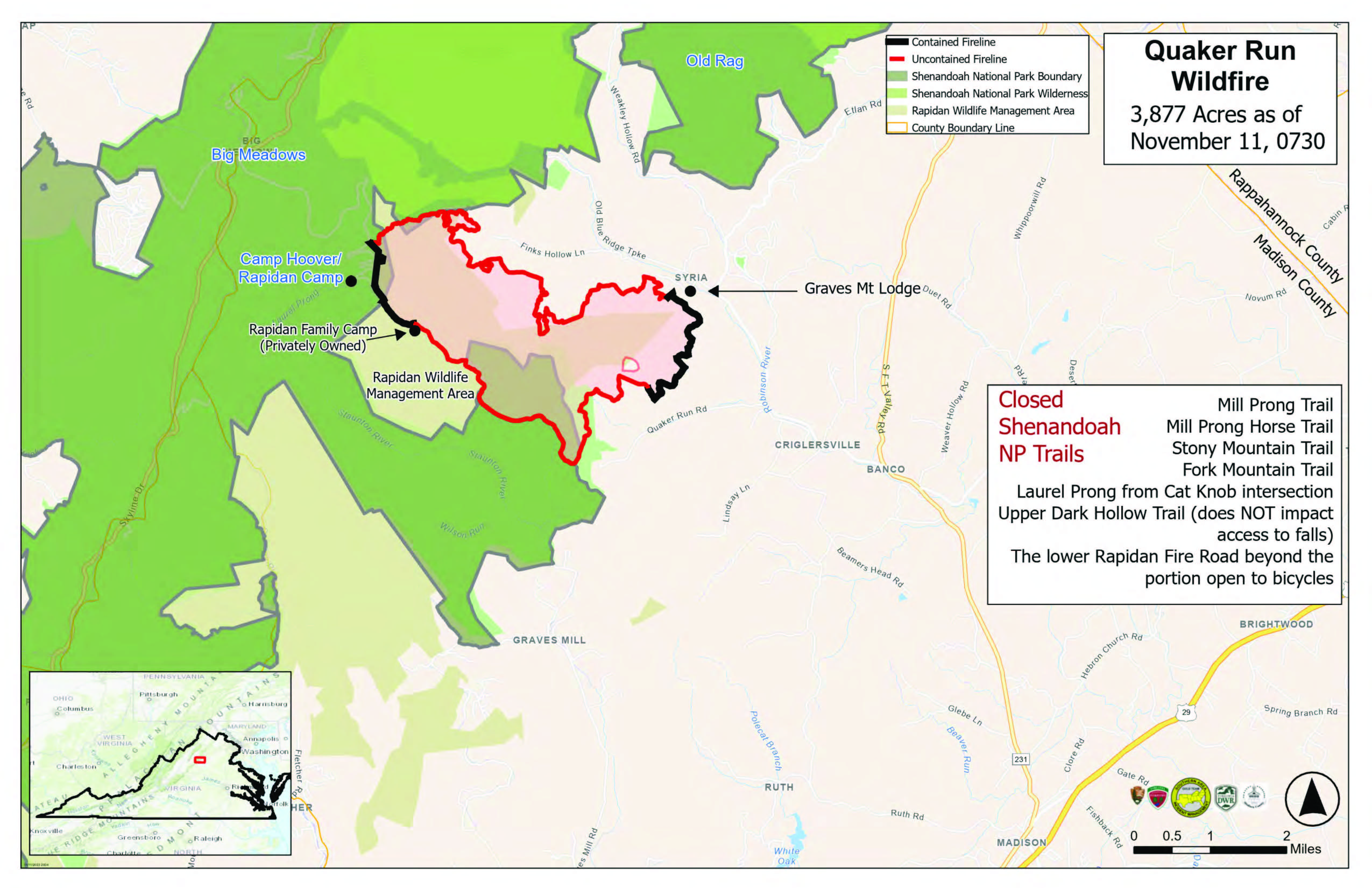
- Acres: 3,877 (increase in acres due to more accurate mapping)
- Containment: 40%
- Location: 970 Quaker Run Road, Syria, VA 22727
- Date of Origin: October24, 2023
- Cause: Undetermined
- Structures Destroyed: 0
- Crews: 9
- Helicopters: 2
- Engines: 7
- Dozers: 6
- Personnel: 201
Fire Activity
Yesterday, firefighters had another productive day mopping up hot spots, strengthening containment lines, monitoring and patrolling. They also checked on the privately owned Rapidan Family Camp and ran sprinklers on and around Camp Hoover, also known as the Historic Rapidan Camp—National Park Service. A video of firefighters working on Camp Hoover is available at https://bit.ly/FFatCampHoover. Crews did find several snags along containment lines and continue to remove those for safety reasons. Fire behavior was minimal with only a few minor and isolated smokes. No one observed open flames or active fire spread.
Today, firefighters will continue with similar work—remove snags, look for and mop up hot spots, strengthen and widen containment lines, monitor and patrol— in preparation for Monday night’s predicted wind event. They will again run the sprinklers around Camp Hoover, as well as check the area around the Rapidan Family Camp and homes in and around Syria.
Weather
Today will get off to a cold start. Afternoon highs will be the coldest temperatures the area will see all week. Some morning clouds will give way to mostly sunny skies around or just before noon. High temperatures will be in the upper 40s on ridges and in the low- to mid-50s in the valleys. Relative humidity will be 45 to 50%. Tonight, will bring mostly clear skies, with low temperatures from 20 to 30 degrees. Maximum relative humidity will be near 90 to 100%. Monday will start even colder, but temperatures will reach as high as 60 degrees. Active fire weather conditions are possible Monday night into Tuesday.
Fire Behavior
Minimal fire behavior is expected today, but fuels are drying and could become modestly available during the afternoon. Cold temperatures this morning will delay the availability somewhat. Any burn window would be short and most likely limited to the mid-afternoon on a south- or west-facing slope. Even then, fire potential would be low and limited to low rates of spread with low flame lengths. Heavy fuels may cause isolated smokes or smoldering
Fire Bans
- Madison County has issued a county-wide burn ban. Outdoor burning is prohibited on all private and public land. Violations are punishable as a Class 3 misdemeanor as well as potential responsibility for the full amount of all expenses incurred in suppressing such fire. For more information, visit https://www.madisonco.virginia.gov/AlertCenter.aspx.
- Shenandoah National Park has implemented a complete fire ban. Building, attending, maintaining or using an open fire anywhere within the boundaries of the park is prohibited. This ban includes all wood, charcoal, coal or other solid-fuel open air fires and fires in grates, grills, rings or pits in campgrounds, picnic areas, shelters and huts. For more information, visit https://www.nps.gov/shen/planyourvisit/quaker-run-fire-information.htm.
Evacuations
There are no evacuations in place for the Quaker Run Fire.
Smoke
Air quality is currently excellent. Additional information is available at https://outlooks.airfire.org/outlook/l/xxx_nz5bvpxt?.
Closures
Shenandoah National Park
The following closures are in effect in Shenandoah National Park:
- Rapidan Camp area near the eastern boundary in the center of the park. The closure includes the area around the historic camp and the trails leading to it including the following:
- Mill Prong Trail
- Mill Prong Horse Trail
- Stony Mountain Trail
- Fork Mountain Trail
- Laurel Prong from Cat Knob intersection
- Upper Dark Hollow Trail (does NOT impact access to falls)
- The lower Rapidan Fire Road beyond the portion open to bicycles
- Graves Mill Trail from the intersection of the Staunton River Trail to the Rapidan Fire Road
- Wilhite Wagon Trail
Rapidan Wildlife Management Area – Rapidan Tract
Due to wildfire activity in the area, the Rapidan Tract of Rapidan Wildlife Management Area is temporarily closed in the interest of public safety. In addition, per Code of Virginia § 29.1-521, it is illegal “to kill or capture any wild bird or wild animal adjacent to any area while a field or forest fire is in progress.”
Temporary Flight Restrictions
A temporary flight restriction is in place over the Quaker Run Fire area from the surface up to and including 6,500 feet to provide a safe environment for firefighting. For more information, visit: https://tfr.faa.gov/save_pages/detail_3_7678.html.
Donations
If you are considering donating to the Quaker Run Fire firefighting efforts, please take them to the Madison County Department of Emergency Medical Services at 1494 N. Main Street, Madison, VA 22727. Thank you.
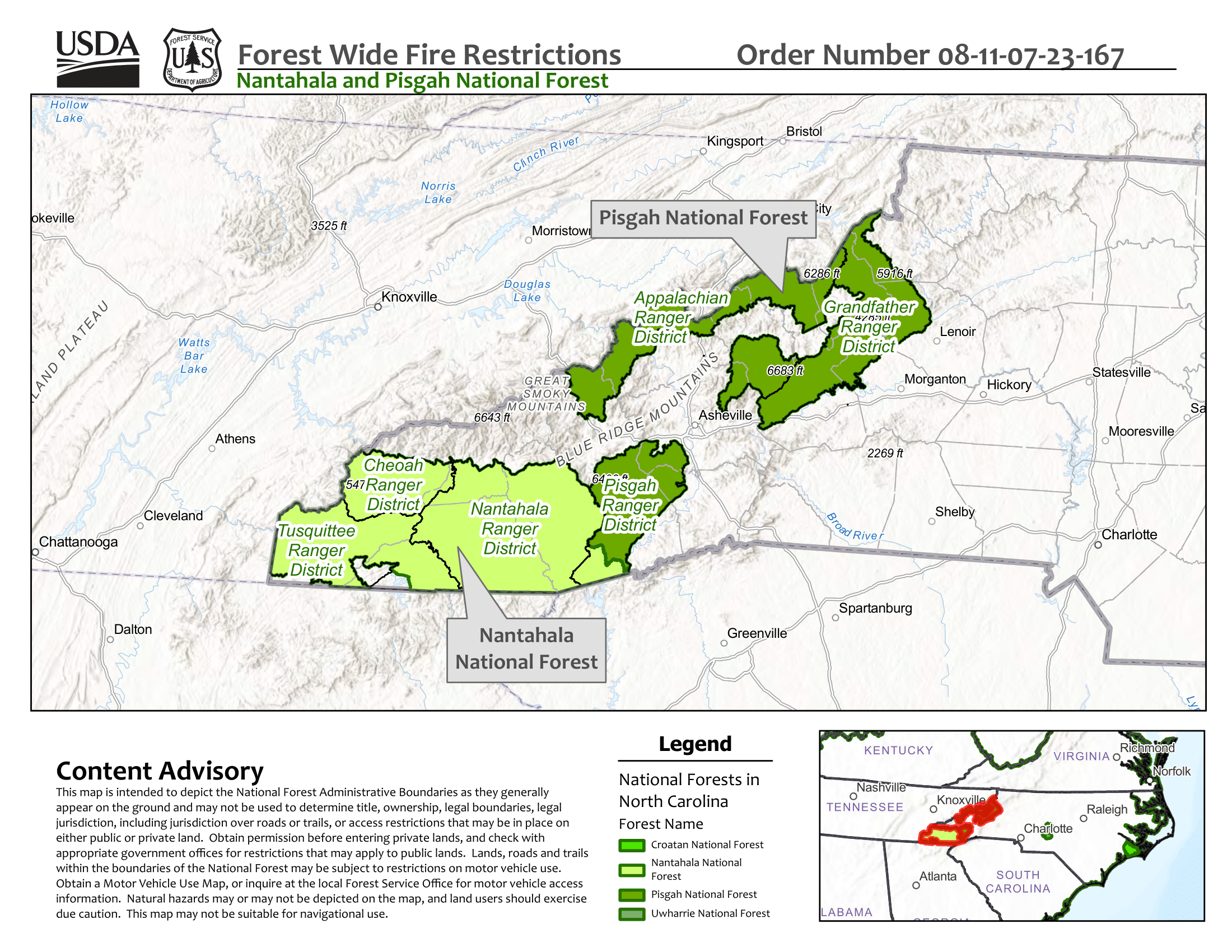
Forest Order Fire Restrictions on Nantahala and Pisgah National Forests
Related Incident: 2023 Collett Ridge Fire
Publication Type: Closures
Pursuant to 16 U.S.C. § 551 and 36 CFR §§ 261.50 (a) and (b), for the protection of public health and safety, the following acts are prohibited on all lands administered by the Pisgah and Nantahala National Forest. This closure is effective from November 7, 2023, through December 31, 2023, or until rescinded by an authorized Forest Service official, whichever occurs first.
1. Building, maintaining, attending, or using a fire or campfire outside of developed recreation sites. 36 CFR § 261.52 (a).
2. Possessing, discharging, or using any kind of firework or other pyrotechnic device. 36 CFR § 261.52 (f).
3. Violating North Carolina state law (NCGS 106-944 & 106-946) concerning burning, or any fire, for the purpose of preventing or restricting the spread of fires. 36 CFR § 261.52(k).
Pursuant to 36 CFR, § 261.50 ( e ), the following persons or areas are exempt from this Order:
1. Persons with a special use permit or contract specifically authorizing the otherwise prohibited act of omission, issued by the Forest Supervisor or District Ranger.
2. Any Federal, State, or local officer, or member of an organized rescue or firefighting force in the performance of an official duty.
3. The use of commercially available fuel stoves (portable gas camp stoves or grills) forest wide.
4. Fire or campfire in a Forest Service provided metal fire pit, metal fire ring, or pole mounted grill at a developed recreation area or campground with a camp host (Balsam Lake Lodge, Curtis Creek Campground, Davidson River Campground, Kimsey Creek Group Camp, Lake Powhatan Campground, North Mills River Campground, Sunburst Campground, Standing Indian Campground, Wolf Ford Horsecamp).
Daily Update Saturday November 11 2023
Related Incident: 2023 Collett Ridge Fire
Publication Type: Announcement
5,335 acres | 15% containment | 244 personnel assigned
Highlights: Fire behavior was moderated yesterday due to the cold front which passed through the area, bringing cloud cover, cooler temperatures, increased humidity, and light precipitation; today’s forecast calls for these conditions to through Sunday morning.
Firefighters will continue to build and improve containment lines in the area of Snider’s Creek Road and McClellan Road today to the northwest of the fire. Engines remained on scene throughout the night to provide point protection for structures. Crews will patrol near the communities of Bolden Branch and Lord’s Way and perform mop-up operations, such as extinguishing any lingering hotspots, as needed.
To the northeast of the fire in the Kimsey Cove area, hand lines were completed, and crews will take advantage of the fire-moderating weather to work on contingency lines to the east. Fire activity along Shinbone Ridge on the southern edge of the fire has been minimal, and fire managers anticipate patrol and mop-up operations to begin soon.
Facebook: https://www.facebook.com/nfsnc/
Resources assigned to the fire includes, five 20-person hand crews, Type 4 and 6 Engines; Dozers; and Water Tenders. Aerial resources include three helicopters.
Weather & Fire Behavior: Light rain is expected over the fire area today along with increased humidity, clouds, and cooler temperature. This trend will continue through the weekend with the possibility of light rain on Sunday. Until sufficient rain occurs, fire activity and growth are expected to continue with areas of heavy fuels potentially causing flareups.
Air Quality: Smoke may occur in nearby communities. Air quality information provided by the North Carolina Department of Environmental Quality is available at airquality.climate.ncsu.edu/.
Burn Bans: Due to increased fire risk, the N.C. Forest Service has issued a ban on all open burning until further notice in several counties in western North Carolina. For more information visit https://www.ncforestservice.gov/fire_control/sit_report.htm
The U.S. Forest Service has implemented fire restrictions across the Pisgah and Nantahala National Forests. To view the closure order visit www.fs.usda.gov/alerts/nfsnc/alerts-notices
Temporary Flight Restriction: A Temporary Flight Restriction (TFR) is in place over the Collett Ridge Fire area. If you fly, we can’t. Aircraft or drone intrusions into the restricted airspace endangers aircrews conducting fire operations and aerial resources are grounded for safety. This unnecessarily places aircrews and ground fire crews at risk in a dynamic and dangerous fire environment.
Closures: For public and firefighter safety the following road and area closures are in effect due to increased fire activity and suppression operations in the area from Big Stamp east to Shinbone Ridge to Signal Bald and a road closure is in effect from the intersection of Little Fires Creek Road, 340B, and Fires Creek Road, 340. The Rim Trail is temporarily closed for approximately 7 miles from Big Stamp to Shinbone.
Daily Update Friday November 10 2023
Related Incident: 2023 Collett Ridge Fire
Publication Type: Announcement
5,116 acres | 5% containment | 178 personnel assigned
Highlights: The Southern Area Blue Incident Management Team assumed command of the fire at 8:00 a.m. today, Friday, November 10, 2023.
Firefighters are assessing structure protection needs for communities to the northwest of the fire in the McClellan Creek area. Engines remain on scene throughout the night to provide point protection as needed. Crews continue to establish handline and dozer lines to the northwest of the fire from Snyder Creek to Polecat Creek. To the south firefighters are strengthening and securing the containment line along Fires Creek Road and when weather permits, are utilizing strategic firing operations to reduce unburned vegetation between the fire and the containment line. Crews are finishing handline to the northeast in the Kimsey Cove area. To the north firefighters continue to patrol the area near the communities of Bolden Branch and Lord’s Way and perform mop-up operations, such as extinguishing any lingering hotspots, as needed.
Facebook: https://www.facebook.com/nfsnc/
Inciweb: https://inciweb.nwcg.gov/incident-information/ncncf-2023-collett-ridge-fire
Resources assigned to the fire includes, three 20-person hand crews, Type 4 and 6 Engines; Dozers; and Water Tenders. Aerial resources include helicopters and fixed wing aircraft.
Weather & Fire Behavior: Light rain is expected over the fire area today along with increased humidity, clouds, and cooler temperature. This trend will continue through the weekend with the possibility of light rain on Sunday. Until sufficient rain occurs, fire activity and growth are expected to continue with areas of heavy fuels potentially causing flareups.
Air Quality: Smoke may occur in nearby communities. Air quality information provided by the North Carolina Department of Environmental Quality is available at www.airquality.climate.ncsu.edu/.
Burn Bans: Due to increased fire risk, the N.C. Forest Service has issued a ban on all open burning until further notice in several counties in western North Carolina. For more information visit https://www.ncforestservice.gov/fire_control/sit_report.htm
The U.S. Forest Service has implemented fire restrictions across the Pisgah and Nantahala National Forests. To view the closure order visit www.fs.usda.gov/alerts/nfsnc/alerts-notices
Temporary Flight Restriction: A Temporary Flight Restriction (TFR) is in place over the Collett Ridge Fire area. If you fly, we can’t. Aircraft or drone intrusions into the restricted airspace endangers aircrews conducting fire operations and aerial resources are grounded for safety. This unnecessarily places aircrews and ground fire crews at risk in a dynamic and dangerous fire environment.
Closures: For public and firefighter safety the following road and area closures are in effect due to increased fire activity and suppression operations in the area from Big Stamp east to Shinbone Ridge to Signal Bald and a road closure is in effect from the intersection of Little Fires Creek Road, 340B, and Fires Creek Road, 340. The Rim Trail is temporarily closed for approximately 7 miles from Big Stamp to Shinbone.
Crews to Return Sunday for Potential Ignitions
Related Incident:
Publication Type: News
Nov. 11, 2023—Fire crews this afternoon conducted a test fire to observe fire behavior after recent rain and snow increased fuel moistures. Fire behavior was low to moderate. Crews plan to return Sunday to monitor conditions and prepare for potential ignitions within the unit.
4,000 acres of the 6,333-acre unit were treated with prescribed fire in October. The remaining 2,333 acres are located north of Forest Road 1950 between a half mile east of McCrystal Campground and Windy Gap.
Crews to Return Sunday
Related Incident:
Publication Type: News
Nov. 11, 2023—Fire crews on Saturday patrolled and monitored as the fire smoldered, crept and backed. They will return Sunday for the same actions and may conduct ignitions if there is conducive weather and ventilation.
Steep Valley Fire November 11th 2023 Update
Related Incident:
Publication Type: News
GLEN JEAN, WV - The Steep Valley Fire increased to 1904 acres overnight Thursday into Friday. The rain on Friday morning andearly afternoon dampened fire activity. However, it continues to burn in the War Ridge and Backus Mountain areas, a remote part of the park within park boundaries. Containment is now up to 29% as of Friday evening. Smoke may be visible when the fire is actively burning, and it may linger in the gorge for several days as it moves across the landscape. The cause of the fire is under investigation.
“Fire activity was diminished significantly due to precipitation over the area on Friday,” said Steep Valley Fire Incident Commander Trainee Nate Orsburn. “Fire activity continues in steep, rugged, and inaccessible terrain making it difficult for crews to put in direct fire line,” Orsburn continued. Firefighter safety remains a number one priority. To date, there has been one minor injury to a firefighter.
As of Friday, 40 firefighters were actively engaged on the fire focused on maintaining and holding existing fire lines due to rain over the fire area. Today, crews will focus on holding maintaining, and improving fire lines as a warming and drying trend is expected for the area starting this weekend. As fuels dry out, fire activity may steadily reanimate, as well.
The War Ridge Campground is currently the only area in the park that is closed at this time. The access road beyond the campground is closed as well. The remainder of the park is open for normal hours of operation. Should fire activity and conditions change, park management will reassess for any needs to adjust parkoperations.
Resources from multiple federal and state agencies from across the country have arrived to assist New River Gorge National Park and Preserve personnel.