
500 More Acres Treated Crews Plan to Return Friday
Related Incident:
Publication Type: News
Nov. 9, 2023—Fire crews continued progress on the Alamosa Unit 1 Prescribed Fire today with 500 acres treated. Approximately 2,100 acres have been accomplished to date.
Crew members used drip torches to continue blacklining along the boundaries of the 4,500-acre unit. Blackining is pre-burning fuels along the control line, in this case roads, before interior areas are treated. The blackline is usually up to 100 feet deep.
Winds were 5 to 10 mph with temperatures in the 40s. Crew members temporarily paused operations in the middle of the day due to sleet and other conditions that were not conducive for burning. Nonetheless, crews accomplished their goal of 500 acres, a number that was set to reduce smoke impacts amid a lower ventilation rate than Wednesday, when 1,600 acres were burned.
Crews will return tomorrow but new ignitions will depend on weather and conditions. If they are able to move forward, up to 1,500 acres could be treated.
When large acres are treated, smoke is expected to mainly move to the east and impact communities and areas in and around the Sangre de Cristo Mountains. Check the Fire and Smoke Map for local air quality and protective actions.
The prescribed fire will help maintain forest health within an area that was first treated with in 2014. Fire-dependent forests in the Southwestern Region must undergo fire disturbance on a regular basis to maintain resiliency. If a future wildfire reaches an area with recent fire history, fire behavior is likely to be modified to a less intense, more manageable surface fire, making it safer for firefighters to engage, as was seen in the nearby Midnight Fire in 2022.
As part of the Rio Chama Collaborative Forest Landscape Restoration Project, prescribed fire in this area also contributes to goals of improving and maintaining the health and resiliency of the Rio Chama and Rio Grande watersheds.
Settings - change map background and toggle additional layers
Filter - control incident types displayed on map.
Zoom to your location
Reset map zoom and position
Could not determine your location.
Show Legend
 Wildfire
 Prescribed Fire
 Burned Area
Response
Burned Area
Response Other
Other
March 2023 Broyles Gap Fire
Unit Information
Incident Contacts
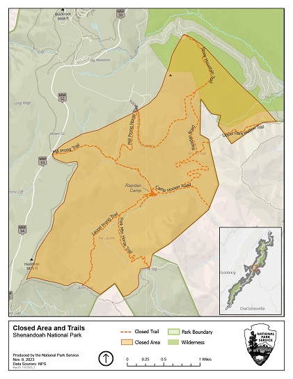
Shenandoah National Park Trail Closures
Related Incident:
Publication Type: Closures
The following closures are in effect in Shenandoah National Park:
- Rapidan Camp area near the eastern boundary in the center of the park. The closure includes the area around the historic camp and the trails leading to it including the following:
- Mill Prong Trail
- Mill Prong Horse Trail
- Stony Mountain Trail
- Fork Mountain Trail
- Laurel Prong from Cat Knob intersection
- Upper Dark Hollow Trail (does NOT impact access to falls)
- The lower Rapidan Fire Road beyond the portion open to bicycles
- Graves Mill Trail from the intersection of the Staunton River Trail to the Rapidan Fire Road
- Wilhite Wagon Trail
The Harry S. Byrd, Sr. Visitor’s Center remains open. The center was scheduled to close due to a power outage for firefighter safety. The power was restored prior to the scheduled closing. For hours and additional information, please visit https://www.nps.gov/shen/planyourvisit/visitorcenters.htm.
Mililani Mauka Fire Daily Update Thursday November 9 2023
Related Incident:
Publication Type: News
FOR IMMEDIATE RELEASE
MILILANI MAUKA WILDFIRE UPDATE
THURSDAY NOVEMBER 9, 2023
The Mililani Mauka Fire is located four miles east of Mililani Mauka in a remote, mountainous area with steep terrain on private lands, Kamehameha Schools lands and the O‛ahu Forest National Wildlife Refuge. The fire remains 90% contained and current acreage is approximately 1,625 acres due to more accurate mapping. The fire footprint did not grow yesterday.
Resources include an interagency hotshot crew, one wildland fire module, ten smokejumpers, two helicopter modules and one type 3 helicopter. There are a total of 63 personnel assigned to the fire. Yesterday, crews identified areas of heat along the fire perimeter and continued to hike into the accessible portions of the fire edge to ensure that all residual heat is identified and extinguished. Significant progress continues on the west and southwest portions of the fire edge closest to Mililani Mauka and the southeast fire edge on Kamehameha Schools lands. Crews will continue to identify and extinguish hot spots and improve the fire perimeter as they traverse accessible portions further around the fire perimeter in this steep and rugged terrain.
Scattered showers will be possible over the fire area today, especially during the overnight and morning hours. Winds will be more southeasterly through Thursday before returning to a more easterly trade wind direction on Friday.
The fire is primarily located within the O‛ahu Forest National Wildlife Refuge. The refuge protects some of the last remaining intact native forest on the island and supports at least 22 federally listed species, including native plants.
For additional information, please contact 2023.mililani@firenet.gov or search for the Mililani Mauka fire on http://inciweb.nwcg.gov.
###
Quaker Run Fire Update 11923
Related Incident:
Publication Type: News
Daily Update for November 9, 2023
Statistics
Acres: 3,700
Containment: 40%
Location: 970 Quaker Run Road, Madison, VA 22727
Date of Origin: October 26, 2023
Cause: Undetermined
Structures Destroyed: 0
Resources
Crews: 9
Helicopters: 4
Engines: 9
Dozers: 4
Personnel: 220
Fire Activity
Yesterday at 9 a.m., the Southern Area Gold Complex Incident Management Team joined the Virginia Department of Forestry in unified command of the Quaker Run Fire. The Gold Team thanks the Virginia Department of Forestry’s Type 3 Incident Management Team for their dedication and hard work on the Quaker Run Fire.
Firefighters held and strengthened containment lines yesterday. Crews successfully conducted a strategic firing operation northeast of Camp Hoover (Rapidan Camp) to the north towards Dark Hollow Trail. Helicopters assigned to the fire made over 50 water drops to slow the fire’s progress, On the fire’s east side, firefighters and hand crews continued to hold containment lines and mopping up. Every effort is being made to protect the historic Camp Hoover. Firefighters put fire hoses and water tanks around the structure so they are ready to respond if the fire moves in that direction.
Today, firefighters may conduct additional firing operations south of Dark Hollow Trail to prevent fire spread to the northeast. The fire is cooler north of the Rapidan Family Camp (privately owned) to the east and southeast, adjacent to the Rapidan Wildlife Management Area. In those areas, crews will continue to monitor and improve containment lines, including removing snags, mopping up and patrolling. Bulldozers, engines and hand crews continue to work off of Finks Hollow Road protecting structures, improving fireline, mopping up and patrolling. Helicopters are available again today to support firefighters on the ground, including two National Guard Black Hawks. However, they may be grounded by high winds later in the day.
Weather and Fire Behavior
Near-record temperatures in the low 80s with breezy conditions are expected today with 15 mph winds and gusts up to 30 mph. A cold front will pass through the area and winds will shift from the SW, W and NW. Relative humidity is expected to drop to critical levels of 30-35%. Tomorrow, conditions should improve with increased cloud cover and higher relative humidity.
The fire is expected to remain active. The chance of embers and leaves blowing across firelines is significant. Burning conditions will be elevated all day.
Fire Bans
Madison County has issued a county-wide burn ban. Outdoor burning is prohibited on all private and public land. Violations are punishable as a Class 3 misdemeanor as well as potential responsibility for the full amount of all expenses incurred in suppressing such fire. For more information, visit https://www.madisonco.virginia.gov/AlertCenter.aspx.
Shenandoah National Park has implemented a complete fire ban. Building, attending, maintaining or using an open fire anywhere within the boundaries of the park is prohibited. This ban includes all wood, charcoal, coal or other solid-fuel open air fires and fires in grates, grills, rings or pits in campgrounds, picnic areas, shelters and huts. For more information, visit https://www.nps.gov/shen/planyourvisit/quaker-run-fire-information.htm
Evacuations
A voluntary evacuation is in place for homes north of 681 Finks Hollow.
Smoke
Smoke continues to impact the area around the Quaker Run Fire. In the Shenandoah National Park, Whiteoak Canyon and Old Rag Trails are open but at times are impacted by dense smoke which may reach unhealthy to very unhealthy levels. These are strenuous trails requiring prolonged heavy exertion. Smoke sensitive groups are advised to avoid these trails. All visitors are encouraged to take precautions as conditions can change quickly. Additional information is available at https://outlooks.airfire.org/outlook/l/xxx_nz5bvpxt?.
Closures
Shenandoah National Park
As of November 7, 2023, the following closures are in effect in the Shenandoah National Park:
- Rapidan Camp area near the eastern boundary in the central park. The closure includes the area around the historic camp and the trails leading to it including the following:
- Mill Prong Trail
- Mill Prong Horse Trail
- Stony Mountain Trail
- Fork Mountain Trail
- Laurel Prong from Cat Knob intersection
- Upper Dark Hollow Trail (does NOT impact access to falls)
- The lower Rapidan Fire Road beyond the portion open to bicycles
- Graves Mill Trail from the intersection of the Staunton River Trail to the Rapidan Fire Road
- Wilhite Wagon Trail
Temporary Flight Restrictions
As of November 6, 2023, a temporary flight restriction is in place over the Quaker Run Fire area from the surface up to and including 6,500 feet to provide a safe environment for firefighting. For more information, visit: https://tfr.faa.gov/save_pages/detail_3_7678.html.
Donations
If you are considering donating to the Quaker Run Fire firefighting efforts, please take them to the Madison County Department of Emergency Medical Services at 1494 N. Main Street, Madison, VA 22727. Thank you.
Contact Information
Email: 2023_QuakerRun@firenet.gov
Phone: (540) 613-1809 (8 a.m. – 8 p.m.)
Facebook: https://www.facebook.com/ForestryVA
InciWeb: https://inciweb.wildfire.gov/vavas-2023-quaker-run-fire
Ignitions Planned as Early as Nov 11 2023
Related Incident:
Publication Type: News
Nov. 7, 2023—After meeting with meteorologists to discuss weather and conditions today, fire managers are tentatively planning returning to Valle Vidal for prescribed fire operations in the McCrystal Rock Unit: Ignitions on the remaining 2,333 acres of this unit in Valle Vidal is tentatively scheduled to begin as early as Saturday, Nov. 11. The remaining acres are on the western third of the unit (see map). Fire crews completed 4,000 acres in mid-October. Ignitions are anticipated to occur over at least three days.
Fire managers will continue to consult with meteorologists for the prescribed fire and will postpone ignitions if weather conditions adversely change.
Public information officers will post updates for both projects to InciWeb (Alamosa, McCrystal), New Mexico Fire Information and Carson National Forest social media channels (Facebook, X).
Ignitions Continuing Today
Related Incident:
Publication Type: News
Nov. 9, 2023—Crews are back on scene of the Alamosa Unit 1 Prescribed Fire. They conducted a successful test burn and are continuing ignitions. Up to 500 acres could be treated to limit smoke impacts due to lower ventilation rates than yesterday.
Surface winds are forecasted to be 5 to 10 mph throughout the day with temperatures in the low to mid 40s. Minimum relative humidity is considerably higher than yesterday at 45 to 49%, according to the National Weather Service spot forecast. With lower number of possible acres burned, smoke may not be widely noticeable. The public can continue to check the Fire and Smoke Map for local air quality and protective actions.
News Release Sugar Bay Wildfire 100 Contained
Related Incident:
Publication Type: News
The USDA Forest Service announced that the Sugar Bay Wildfire in Allegheny National Forest reached 100 percent containment.
Suppression efforts by Allegheny National Forest staff on November 8 were highly effective. The Glade Volunteer Fire Department and the US Army Corps of Engineers provided transportation to the fire by boat, greatly enhancing the efficiency of the operation. Given the weather forecast, fire activity is projected to remain minimal. Wildland firefighters will continue to monitor the area over the next few days.
Pile Burning FAQ 11 29 2023
Related Incident: Arapaho and Roosevelt National Forests Pile Burning
Publication Type: News
Q: What is a pile burn?
A: Pile burns are a type of prescribed fire where firefighters pile and burn forest debris to reduce an area’s wildfire risk. Piles are only ignited under certain conditions, including favorable smoke dispersal and adequate snow cover, which helps contain the piles. These conditions direct firefighters on where within project areas burning can occur due to the localized nature of conditions. Smoke, flames, and glowing embers are often visible and are a normal part of pile burning operations, and they can be visible throughout the night. Firefighters monitor the area until the piles are considered out. Public and firefighter safety is always the number one priority in burning operations. Prescribed fire is an important tool for decreasing long-term fire risk to communities and to restore our forests so they are more resilient to natural fire in the future.
Q: Why do you burn piles when it is windy?
A: Firefighters watch the forecast very carefully for favorable weather conditions and can safely burn piles in windy conditions. We analyze the short term and extended forecast every time we ignite. While wind is needed for smoke dispersal, if winds are forecast that could potentially create fire behavior that would put communities or residences at risk, firefighters don’t ignite piles.
If conditions do allow firefighters to burn piles, it isn’t unusual for wind to cause more smoke and flames to be visible in the days after ignitions begin. Open flame and flare ups can occur and be visible to surrounding communities, especially during wind events and patchy snow conditions. Areas in between piles within the prescribed fire unit are sometimes allowed to burn. This can reduce more hazardous fuels, therefore further reducing the overall wildfire risk. It’s important to note that even with the most thorough planning and preparation, the use of prescribed fire carries an inherent level of risk that cannot be eliminated entirely. At the same time, prescribed fire is one of the most efficient and effective ways to reduce wildfire risk.
Q: What should I expect when burning occurs?
A: Expect to see flames at pile locations and smoke in the area until firefighters call the piles out. Over time the heat and flames from the piles becomes less intense as the fuel is consumed. Mild fire behavior between piles is expected and is beneficial for future wildfire risk reduction. This includes forest litter and debris between piles and lower limbs of trees. This mild type of burning helps reduce available flammable fuels.
Q: How long do the piles burn for?
A: Pile burn areas can remain active and smolder for days to weeks after they are ignited. In most cases the piles go out naturally, but on rare occasions firefighters will suppress burning debris that have not gone out on their own.
Q: How do you ensure fire stays within your project area and doesn’t threaten communities, landowners, residences, and infrastructure?
A: Patrolling and Monitoring:
- We patrol and monitor our previous pile burns until they can be declared “out,” or cold.
- When a change in weather occurs, we adjust the monitoring and patrolling schedule appropriately.
- It is not unusual for smoke and flame to be present for up to a week after burning a small slash pile, and longer for larger piles.
Public and firefighter safety are our top priority. That said, we can’t remove all risk associated with prescribed burning.
- We make decisions based on the best available science. We insure we have adequate resources and staffing available.
- High winds are a regular event along Colorado’s Front Range, and we analyze the short term and extended forecast every time we ignite. Piles can burn for a longer duration than our forecast is reliable.
- With the amount of forest management work that we need to do across the Front Range to address the wildfire crisis over the next decade, we must be prepared for strong wind events to occur between pile burning ignitions.
- Being prepared includes making sure we have the sufficient staffing, resources, and coordination with partners, including local fire departments.
Q: Do firefighters watch the burning piles 24 hours a day?
A: When site-specific conditions dictate it is safe to do so, firefighters may leave burning piles overnight. When an unfavorable change in weather occurs, they adjust the monitoring and patrolling schedule to accommodate.
Q: Is smoke from pile burning unhealthy?
A: Burning piles produces smoke and breathing too much smoke may affect your health. Pile burning often produces far less smoke than a large wildfire. Often, smoke from pile burning does not impact the public. Firefighters look for conditions with favorable wind to aid smoke dispersal, lifting smoke up and away to keep the impact low for local communities. For more information see https://www.colorado.gov/pacific/cdphe/wood-smoke-and-health.
Q: How many piles can you burn in one day?
A: We obtain smoke permits from the State of Colorado and these permits will have limitations on the number of piles we can burn in one day to minimize smoke effects. When conditions are favorable, it is not uncommon to burn more than 500 piles a day within a project area.
Q: Why are you killing trees when burning piles?
A: Standing live trees may be affected by our pile burning. It is common and acceptable to have “scorched” trees within our project areas. Many, if not most, of these trees will not die. Approximately 2/3 of a tree crown can be scorched without killing the tree. That said, if the top of the tree is scorched or burned, the tree will most likely die. We take precautions when lighting piles to avoid this, but it is within our planning specifications to accept minimal tree mortality.
Q: What alternatives are there instead of burning the piles?
A: Pile burning is the most efficient option to reduce forest debris at the scale and speed needed to meet our goals and reduce wildfire risk.
One alternative would be to leave piles, but it is unclear how that would affect the forest, it creates a visual problem, and it would not reduce hazardous forest fuels which is the intent.
Other options for utilizing forest debris are slowly gaining traction in the Rockies. Driven largely by the push to develop more renewable energy sources, forest debris and other wood waste is being used to generate heat and electricity, biofuels, and products such as biochar and activated carbon. One USDA-funded regional project, the Bioenergy Alliance Network of the Rockies (BANR), is exploring the use of beetle-killed forest biomass as a bioenergy feedstock. Colorado’s first biomass plant, located in Gypsum, has been generating electricity from beetle-killed trees since 2013. Still, there will always be piles that are too inaccessible to be transported, and so continued work for mitigating pile burn effects will remain relevant, especially for sensitive and inaccessible areas.
First Day of Ignitions Completed
Related Incident:
Publication Type: News
Nov. 8, 2023—Fire crews made significant progress on their first day of ignitions on the Alamosa Unit 1 Prescribed Fire. Approximately 1,600 acres within the 4,500-acre unit were treated.
Crew members used drip torches to put fire on the forest floor around the unit’s northeastern boundary before interior sections were ignited by helicopter. Low to moderate-intensity fire traveled across the ground, successfully consuming surface fuels, such as pine needles, fallen leaves and Gambel’s oak.
On-site winds were a brisk 7-11 mph with gusts up to 16 mph. Temperatures were in the low 50s with a low relative humidity or 18-22 percent.
Crews will return tomorrow but new ignitions will depend on weather and conditions. They will, nonetheless, patrol and monitor the prescribed fire on the ground and by air.
When ignitions do occur, smoke is expected to mainly move to the east and may impact areas as far as the Taos and Moreno valleys. Check the Fire and Smoke Map for local air quality and protective actions.
The prescribed fire will help maintain forest health within an area that was first treated with in 2014. Fire-dependent forests in the Southwestern Region must undergo fire disturbance on a regular basis to maintain resiliency. If a future wildfire reaches an area with recent fire history, fire behavior is likely to be modified to a less intense, more manageable surface fire, making it safer for firefighters to engage, as was seen in the nearby Midnight Fire in 2022.
As part of the Rio Chama Collaborative Forest Landscape Restoration Project, prescribed fire in this area also contributes to goals of improving and maintaining the health and resiliency of the Rio Chama and Rio Grande watersheds.