
Trail Springs and Mill Creek 2 Fire Update November 6 2023
Related Incident: Trail Springs FireMill Creek 2 Fire
Publication Type: News
Update: November 6, 2023
Type 3 Team, Incident Commander Scott Bovey, 112 Personnel
The fire danger level is currently high, so it is important that forest users completely drown campfires to prevent unintended escape. Use the “drown, stir, feel” method to be sure it's dead out.
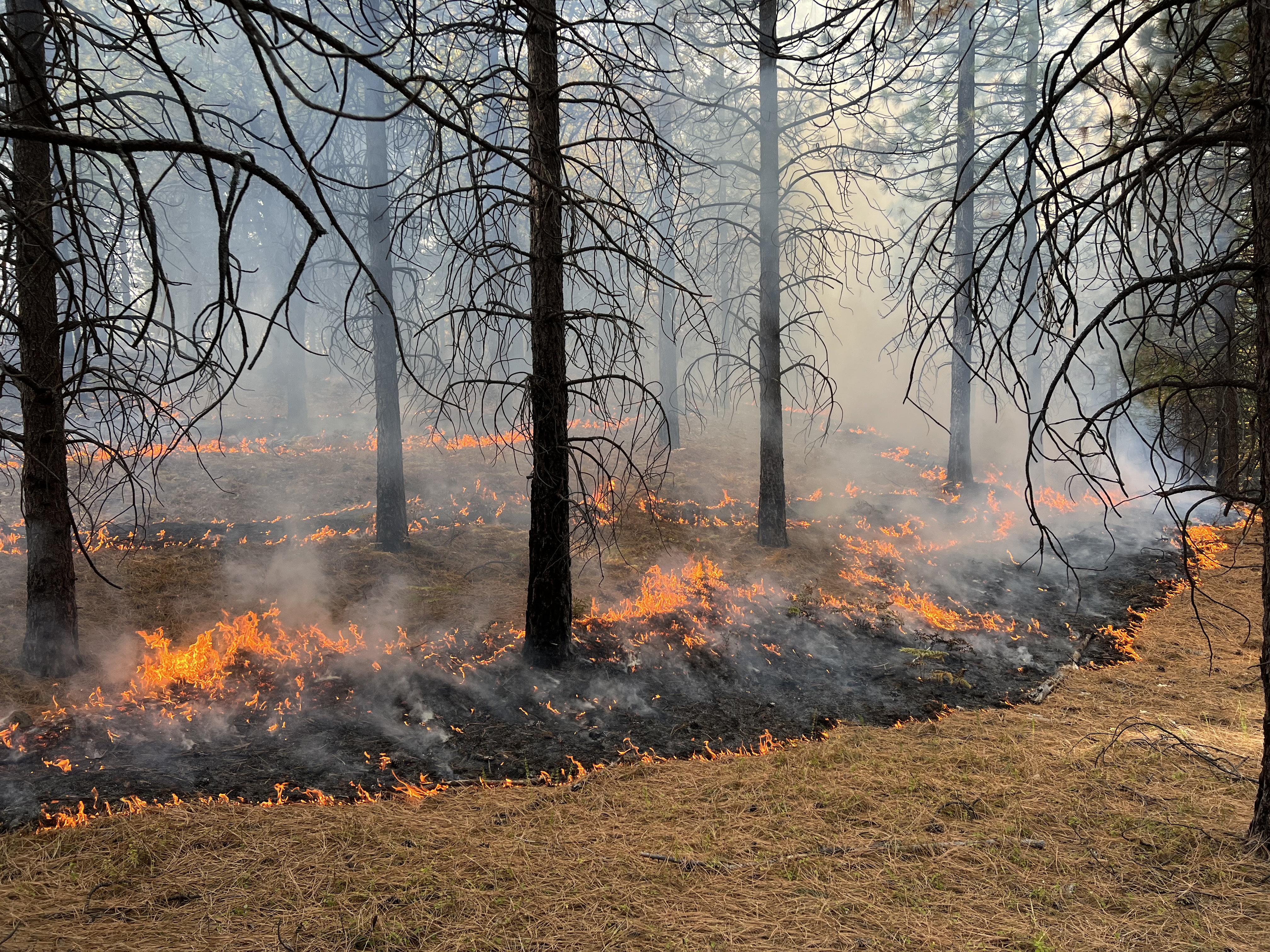
Trail Springs Fire | Size: 1269 Acres | Containment: 37% | Cause: Lightning
Saturday’s infrared mapping flight showed approximately 18 acres of growth, primarily to the north. There’s still some heat in the West Fork of Devil Creek drainage on the west side of the fire but it has not crossed the creek. Little to no growth is expected to the south due to the presence of the Chris Mountain Fire scar and the east side is contained. Crews have completed the work that was being done to create a shaded fuel break on the west side of Corral Mountain Road and the chipping along East Monument Road. Select resources assigned to this fire remain available to assist local agencies with new fires. They were dispatched to help suppress several new starts over the weekend. On Trail Springs, firefighters will be continually patrolling to make sure isolated areas of active fire are not advancing beyond the limits defined in the incident objectives.
Mill Creek 2 Fire |Size: 126 Acres | Containment: 0% | Cause: Human
This fire is located in rugged, remote terrain near the border of the South San Juan Wilderness Area northeast of Pagosa Springs. Saturday’s infrared data showed that scattered pockets of heat remained within the fire perimeter and the fire area grew approximately four acres in size. Yesterday’s gusty weather created more smoke than what has been seen for the past couple of weeks and that smoke may continue tomorrow. Firefighters investigated the smoke and confirmed that it poses no threat.
Weather: Another sunny day, with no chance of rain in the forecast. Winds are expected to come from the west, shifting to the southwest in the afternoon, at 10-15mph. Relative humidity will be in the low 20’s again.
San Juan NF Temporary Closures: An area closure is in place involving roads and trails in or near the Trail Springs Fire area (Middle Mountain area). Details of the closure are on the Trail Springs Fire InciWeb page (QR code below) and on the “Alerts and Notices” page of the forest website: https://www.fs.usda.gov/alerts/sanjuan/alerts-notices
A Temporary Flight Restriction is in effect: https://tfr.faa.gov/save_pages/detail_3_8962.html#areas
Fire Information: 970-426-5370 (8 a.m. to 8 p.m.) | Facebook: https://www.facebook.com/sanjuannationalforest
Nov 6 2023 Suppression efforts continue on 543acre Maid Fire
Related Incident:
Publication Type: News
FLAGSTAFF, Ariz., Nov. 6, 2023 — Firefighters continue to work on containing the Maid Fire on Apache Maid mountain just southeast of Interstate 17’s Stoneman Lake exit.
By using a drone, firefighters were able to accurately map the perimeter of the wildfire, which is currently 543 acres and 0% contained, though containment numbers should increase in the next couple of days.
Firefighters also used a drone yesterday to conduct burnout operations in steep and difficult terrain on the west side of the mountain, while hand ignitions were conducted on the southern side, using a forest road as a control feature.
Crews plan on focusing their efforts today on the west and southwest sides of Apache Maid mountain, connecting burnout operations from forest roads to the fire itself to increase control. Weather and wind will be a determining factor as to whether they are able to continue burnout operations and how much they are able to accomplish today.
Smoke is predicted to move in a northeast direction and will be heavy today if burnout operations continue. Aside from weather and wind conditions, rough, rocky, and steep terrain create challenges for on-the-ground suppression efforts.
Resources on scene include four crews, two engines, a dozer, one helicopter and a medic team, equating to 81 personnel. This wildfire is very visible to surrounding areas such as Camp Verde, Sedona and Rimrock, as well as those driving along Interstate 17 between the mileposts of 285-310.
The human-caused wildfire was first reported at 5:11 a.m. on November 4 by a member of the public, and the specific cause is under investigation. Details about the wildfire will be updated daily on the 2023 Maid Fire Inciweb site online.
November 6 2023 Pile Burning Update
Related Incident: Lolo National Forest Prescribed Fire Operations
Publication Type: Announcement
Pile burning will continue across several districts today and throughout the week on the Lolo National Forest. Pile burning helps reduce the amount of fuels that are available to burn, lowering a wildfire’s intensity and reducing risks to firefighters and communities.
Missoula Ranger District: Firefighters will be burning 20 acres of piles by hand approximately in Marshall Canyon. Smoke may be visible from I-90 along East Missoula and Bonner.
Plains/Thompson Falls Ranger District: The Plains/Thompson Falls District will conduct pile burning on two different units located 5 miles southwest of Thompson Falls, near Prospect Creek and 18 miles northeast of Plains in the North Fork Little Thompson drainage. Smoke may be visible from Thompson Falls and Plains.
Superior Ranger District: Firefighters will initiate up to 20 acres of pile burning operations on two different units located 3 miles east of Superior in the Johnson Creek drainage and 3 miles northeast of Superior, in the Flat Creek drainage. Smoke may be visible from Superior and I-90.
Learn more about prescribed fire at: https://www.fs.usda.gov/detail/lolo/fire/?cid=fseprd1139761
Current Pile Burning Activity11 06 2023
Related Incident: Arapaho and Roosevelt National Forests Pile Burning
Publication Type: Announcement
Update (11/6/23): Due to warmer conditions over the weekend, pile burning is on hold until later in the week. Firefighters continue to monitor the piles that were burned last week.
Areas where piles could be burned this week as conditions allow:
Near the Fair Subdivision, east of Tabernash along Water Board Rd (FSR 128). See map
Smoke may be visible in the Fraser Valley and over the divide. Please do not call 911.
Join our email list for a weekly update on prescribed burning or general Forest information! http://tiny.cc/w0ddvz
Nov 5 2023 Wildfire on Apache Maid mountain grows to more than 200 acres
Related Incident:
Publication Type: News
FLAGSTAFF, Ariz., Nov. 5, 2023 — The Maid Fire, located on Apache Maid mountain 17 miles northwest of Clints Well, has grown to more than 200 acres as crews have worked overnight to protect Apache Maid lookout tower and used surrounding forest roads as control features.
Resources currently on scene include three crews, four engines, one dozer, one helicopter, and Jerome Fire Department, which equates to about 90 firefighting personnel.
Firefighters used burnout operations around the lookout Saturday to protect it from the wildfire moving up the mountain and consuming it.
Crews plan to spend the next two days (Sunday – Monday) conducting burnout operations near surrounding forest roads to create better control of the movement of wildfire and keep it from moving across the landscape.
Smoke is predicted to move in a northeast direction and will be heaviest the next two days as burnout operations commence. Rough and rocky terrain and steep mountain faces create challenges for on-the-ground suppression efforts.
This wildfire is very visible to those driving along Interstate 17 near the Stoneman Lake exit since it is only 5 miles from the interstate.
It’s possible that smoke from the wildfire may settle and drain in the evening hours in places like Wet Beaver Wilderness, which could drain toward communities such as Rimrock.
The human-caused wildfire was first reported at 5:11 a.m. Saturday by a member of the public, and the specific cause is under investigation.
Nov 4 2023 Crews responding to 25acre Maid Fire near Apache Maid lookout
Related Incident:
Publication Type: News
FLAGSTAFF, Ariz., Nov. 4, 2023 — Crews are responding to the 25-acre Maid Fire, located approximately 17 miles northwest of Clints Well near Apache Maid lookout (GPS: 34.723056, -111.543889).
Resources responding to the fire include three engines, multiple firefighter crews and personnel, one helicopter, one dozer, Taylor and Jerome fire departments. Additional resources have been ordered.
The fire is moving at a moderate rate of spread through ponderosa pine and grass and is producing visible smoke to those in the immediate area.
This fire was reported early this morning and its cause is under investigation.
There are no closures associated with the Maid Fire at this time, but forest visitors are asked to avoid the fire area and remain cognizant of firefighting efforts.
Trail Springs and Mill Creek 2 Fire Update November 4 2023
Related Incident: Trail Springs FireMill Creek 2 Fire
Publication Type: News
Update: November 4, 2023
Type 3 Team, Incident Commander Scott Bovey, 112 Personnel
Notice: This update will now occur every other day unless significant activity occurs.
The fire danger level is currently high, so it is important that forest users completely drown campfires to prevent unintended escape. Use the “drown, stir, feel” method to be sure it's dead out.
Trail Springs Fire | Size: 1251 Acres | Containment: 37% | Cause: Lightning
Fire activity has been minimal over the past few days. Large fuels, such as stumps and logs, continue to smolder and just a few areas have shown active backing to the northeast within the existing footprint. There was a small spot fire to the north of the main perimeter yesterday that firefighters were able to extinguish. Crews finished repairing the handlines located where fire growth is no longer a threat. There still remains several days of chipping, cutting, and brush removal along East Monument Road and Corral Mountain Road. A NIROPS flight is scheduled for Saturday night to measure the heat remaining within the area’s fires. NIROPS is the National Infrared Operations program that flies thermal infrared detection and mapping missions. Their equipment can detect heat sources as small as 6 inches from 10,000 feet above ground. An interpreter works with the incident’s GIS mapping specialists to turn the infrared data they collect into meaningful maps that are a critical tool for fire management.
Mill Creek 2 Fire |Size: 122 Acres | Containment: 0% | Cause: Under Investigation
This fire is located in rugged, remote terrain near the border of the South San Juan Wilderness Area. On their last recon flight, firefighters spotted only a few isolated locations still smoldering. Firefighters will continue to observe fire activity via aircraft until heat is no longer detected.
Weather: There is still no sign of precipitation in the five-day forecast. Temperatures will increase slightly this weekend with highs in the mid-60’s. Winds remain light out of the west tomorrow but may get gusty on Sunday.
Lafitte Fire Daily Update November 4 2023
Related Incident: Lafitte
Publication Type: News
Lafitte Fire Update
November 4, 2023
Fire Information Phone: (504) 382-0291
Email: Meredith_Hardy@nps.gov
Incident Commander: Fulton Jeansonne (11/4-11/5), Ruben Pedraza (11/6)
Size: 147 acres | Containment: 90% | Total Personnel: 54 | Location: 0.5 miles north of Jean Lafitte, 1.5 miles north of Barataria | County: Jefferson | Start Date: October 17, 2023 | Cause: Undetermined
This will be the last Fire Update published by the Incident Management Team. Questions or concerns regarding this fire should be directed to Meredith Hardy of the National Park Service.
Jean Lafitte, LA – Fire officials have nearly accomplished the incident objectives for the Lafitte Fire in the Jean Lafitte National Historical Park and Preserve. Fire containment has reached 90% and is contained in the 147-acre footprint.
This week- The Incident Management Team will be in place until Sunday, November 5th when downsizing should be completed and transition to a local Incident Commander (IC4) will take place.
Smoke persists in the general area and is coming from other south Louisiana fires. No smoke nor heat exists in the Lafitte Fire area, however firefighters continue to patrol and monitor for any activity. Backhaul of hose, sprinklers and other equipment is ongoing. Minimal resources will remain on the fire to ensure it remains out. Firefighters who are no longer needed on the Lafitte Fire are getting reassigned to other fires in the Eastern and Southern Regions.
Special Note- As hunting season continues and cooler temperatures prevail, it will be critical that locals, accustomed to having warming fires while hunting, curtail this activity as fire danger will remain high in the region until rains arrive. Hunting and firearm discharge near the Lafitte Fire is discouraged as there will be firefighters patrolling the area for a couple of more weeks.
Weather- Northeast winds of 5 to 10 mph can be expected both today and on Sunday. Temperatures will reach in the high 70s this weekend. Relative humidity will remain in the 55 to 60 percent range on Saturday, but a push of drier air into the area on Sunday will result in lower humidity of 35 to 40 percent during the afternoon hours. Tonight, humidity will recover to near 100 percent, but conditions do not look favorable for fog development.
Firewise/Wildland Fire Prevention- This online resource is designed for homeowners to help them prepare their homes to withstand ember attacks and minimize the likelihood of flames or surface fire touching the home or any attachments. Embers are burning pieces of airborne wood and/or vegetation that can be carried more than a mile through the wind and can cause spot fires and ignite homes, debris and other objects.
Firewise: https://www.nfpa.org/Public-Education/Fire-causes-and-risks/Wildfire/Preparing-homes-for-wildfire
Lafitte Fire Information: https://inciweb.nwcg.gov/incident-information/lajep-lafitte
National Park Service Information: https://www.facebook.com/JeanLafitteNPS
Prescribed Fire Updates Nov 3 2023
Related Incident: Mendocino NF Fall 2023/Spring 2024 RX Fire Projects
Publication Type: News
Ignitions were successful yesterday on the 34-acre understory burn at Howard Mill (near the junction of M1 and 16N01 Road on Elk Mountain).
Upper Lake District fire crews and Northshore FPD’s Hogback Ridge Fuels Crew implemented the burn with goals to reduce surface fuels, shrub cover while protecting oaks and overstory trees.
Crews will continue to monitor and patrol this weekend and into next week. Smoke may be visible on Elk Mountain Road near the burn unit.
See video of the Howard Mill understory burn.
.
Current Pile Burning Activity11 03 2023
Related Incident: Arapaho and Roosevelt National Forests Pile Burning
Publication Type: Announcement
Update (11/3/23; 3 p.m.): Pile burning ignitions near the Fair subdivision east of Tabernash have ended for the weekend. Firefighters completed 1,000 piles today for a total of 1,500 piles. The pile burning project will resume in the same area on Monday.