
Lafitte Fire Update October 31 2023
Related Incident: Lafitte
Publication Type: News
National Park Service U.S. Department of the Interior
Jean Lafitte National Historical Park and Preserve
Lafitte Fire Update
October 31, 2023
Fire Information Line – (504) 382-0291
2023.lafitte@firenet.gov
Fulton Jeansonne, Incident Commander
Size: 147 acres | Containment: 60% | Total Personnel: 63 | Location: 0.5 miles north of Jean Lafitte,
1.5 miles north of Barataria | County: Jefferson | Start Date: October 17, 2023 | Cause: Undetermined
Fire Updates will be published every other day.
Special Note- Please help firefighters by following all local regulations. “If you fly, we can’t.” https://www.fs.usda.gov/managing-land/fire/uas/if-you-fly Unauthorized drone flights pose serious risks to firefighter and public safety and disrupt the effectiveness of wildfire suppression operations. Airspace restrictions are called Temporary Flight Restrictions (TFRs) and are communicated to pilots through Notices to Air Missions (NOTAMs). They restrict aircraft (including float planes & drones) from operating without permission in a certain area for a limited time. You must always check NOTAMs prior to your flight. Incursions into the TFR have occurred over the last couple of days. Drone incursions within wildfire areas with active aerial operations create a collision risk and may result in aircraft being grounded until the threat is mitigated. These delays adversely affect the safety and efficiency of the overall firefighting effort.
Jean Lafitte, LA - The Lafitte Fire in the Jean Lafitte National Historical Park and Preserve has not exceeded its October 21st footprint. It is still 147 acres. However, containment has increased to 60% as a result of firefighters’ efforts including tactical saturation of hot spots. Any smoke that is produced by the fire is due to burning within the interior of the fire’s containment lines.
This week- Firefighters have deployed fire hose, set up sprinklers, and erected portable tanks across the fire area in an effort to saturate the ground with fresh water and extinguish the fire. With a thermal imaging capable drone, firefighters are able to precisely identify hot spots and then extinguish them.
Weather- The National Weather Service in New Orleans has issued a Red Flag Warning for Critical Fire Weather Conditions, which is in effect on Tuesday, October 31st from 10am-7pm. Winds are expected to be 10-20 mph with gusts up to 35 mph. Humidity is expected to drop to as low as 20%. Mostly cloudy skies are forecast with a 20% chance for showers in the morning. On Wednesday, a Fire Weather Watch is in effect. The forecast calls for a sunny day with highs on the upper 50s and north winds 15-20 mph with gusts possible up to 40 mph.
Lafitte Fire information link: https://inciweb.nwcg.gov/incident-information/lajep-lafitte
National Park Service information link: https://www.facebook.com/JeanLafitteNPS
Crews Wrap Up Pile Burning for Now
Related Incident:
Publication Type: News
Fire crews completed another 45 acres of pile burning within the Taos Ski Valley resort area today. With 90 acres accomplished, all high-priority areas that would immediately affect winter visitors have been mitigated. The remaining 113 acres of piles will be treated at future time. The piles are the result of fuels reduction, mostly blowdown from the December 2021 snow squall. Other piles were created from hazard tree mitigation and trail development.
Crew members used drip torches to light piles that were dusted with snow overnight. The fire consumed the piles and by the end of operations, smoke was drifting away from the valley.
Today’s ignitions were conducted by numerous partners, including two new groups today. The All-Hands All-Lands Burn Team from the Forest Stewards Guild and members of the Carson Hotshots joined Taos Ski Valley resort staff, Village of Taos Ski Valley Fire Dept., Red River Fire Dept., Latir Volunteer Fire Department, Taos County Fire Dept. and other Forest Service personnel.
Crew members will now monitor and patrol the piles until they are called out.
Nearby piles visible along Highway 150 and the Wheeler Peak Trail are slated for burning this winter. They were created from 300 acres of thinning as part of the Highway 150 Corridor Wildland Urban Interface Project.
Both projects are in the Enchanted Circle Landscape and support efforts of the Wildfire Crisis Strategy.
Prescribed Fire Updates Oct 30 2023
Related Incident: Mendocino NF Fall 2023/Spring 2024 RX Fire Projects
Publication Type: News
Last week Upper Lake District fire personnel completed 54 acres of pile burning in the Lake Pillsbury basin (Westshore and Pillsbury Homesites) last week. Burning operations were patrolled over the weekend, and patrols reported no issues with the weather or wind. For this week district personnel are planning an understory burn at Howard Mill for approximately 30-70 acres, pending favorable weather conditions. Ignitions would begin on Thursday, Nov. 2.
On the Grindstone District fire personnel completed 10 acres of pile burning last week. Conditions have been ideal for pile burning, and the district will continue to burn up to 23 acres of piles this week—at Snow Basin, Three Prong, Pacific Ridge, and Toomes Camp. The weather forecast beginning this Thursday through the weekend is showing light precipitation.
Ignitions Proceeding
Related Incident:
Publication Type: News
Oct. 30, 2023—Fire crews are continuing with ignitions today. Read last night's update for the latest information.
Trail Springs and Mill Creek 2 Fire Update October 30 2023
Related Incident: Trail Springs FireMill Creek 2 Fire
Publication Type: News
Type 3 Team, Incident Commander Scott Bovey, 156 Personnel
Trail Springs Fire | Size: 1250 Acres | Containment: 37% | Cause: Lightning
Thanks to the hard work of firefighters and support personnel, along with a fortunate break in the dry weather, the entire eastern edge, as well as the large spot fire to the northeast of the main perimeter, are now contained. Precipitation was sparse over the fire area yesterday. As the clouds lifted midday, smoke became visible again over the West Devil Creek drainage. Logs, stumps, and other large fuels continue to smolder and fire is still creeping through the duff layer within the fire perimeter. Fire managers say the smoke will remain for some time, especially as we move into a high pressure system that brings back drier weather. The western portion of the fire remains inaccessible to ground resources, so the strategy for suppression continues to be confine and contain using indirect tactics.
Yesterday, firefighters were able to accomplish a great deal of clean up and suppression repair work. They removed brush that had been cut and piled during fireline construction by chipping and burning slash piles. Crews also continued clearing “ladder fuels” - any vegetation that allows flames to climb into the canopy, such as brush and the lower limbs of trees - along East Monument Road. This will make the road more effective as a fireline if fire behavior changes on the Trail Springs Fire, or if another fire occurs in this area in the future. They will continue this work today.
Fire Danger remains Moderate despite recent winter weather, so it is important that Forest users completely drown campfires to prevent unintended escape. Use the “drown, stir, feel” method to be sure it's dead out.
Mill Creek 2 Fire |Size: 121 Acres | Containment: 0% | Cause: Under Investigation
No growth or increased fire behavior has been observed on the Mill Creek 2 Fire. A small number of firefighters are positioned nearby and ready to respond, if needed. An aerial infrared survey is scheduled for Monday night to see if any areas of heat remain.
Weather: Drier and much colder weather is forecast for the next couple of days, followed by a warming trend mid-week. Winds are expected to remain light. However, relative humidity levels will decrease significantly as the week progresses.
San Juan NF Temporary Closures: An area closure is in place involving roads and trails in or near the Trail Springs Fire area (Middle Mountain area), including Forest Road 630, East Monument Road, at its intersection with Turkey Springs Road. Details of the closure are on the Trail Springs Fire InciWeb page (link and QR code below) and on the “Alerts and Notices” page of the forest website: https://www.fs.usda.gov/alerts/sanjuan/alerts-notices
A Temporary Flight Restriction is in effect: https://tfr.faa.gov/save_pages/detail_3_8962.html#areas
Saint Charles Daily Update 10302023
Related Incident: Saint Charles Fire
Publication Type: News
Saint Charles Fire Update
Monday, October 30, 2023 – 9:00 a.m.
Rocky Mountain Complex Incident Management Team 1
Dan Dallas, Incident Commander
Information Phone: 970-628-0130
Email: 2023.saintcharles@firenet.gov
Information Staffing Hours: 8 a.m. to 8 p.m.
Current Situation:
The Saint Charles Fire is 459 acres and 23% contained. This morning, operations will be delayed until the snow melts enough to safely gain proper access to the fire perimeter. The snowfall and colder temperatures have slowed the fire’s growth and reduced the fire behavior. Wet and icy conditions remain around much of the fire. All of the fireline has been accessed by firefighters with the exception a small section of the northeastern corner that is within a rock cliff area.
Firefighters were not on the line Sunday due to inclement weather posing increased risk to firefighters. Crews utilized the opportunity to conduct trainings on general medical response and field evacuations as well as catch up on administrative tasks and maintenance. The Saint Charles Fire will begin to release some of the assigned resources that have completed their duties.
Snow did not suppress the fire; heavier fuels will continue to burn within the perimeter. The fireline will need to be improved and mopped up before full containment is achieved. Warmer temperatures and dryer conditions are predicted throughout the week. As conditions return to more seasonal norms, smoke may again be visible from inside the perimeter.
Weather, Fuels, and Fire Behavior:
The passing cold front delivered a blast of winter weather to the area Sunday with a substantial drop in temperatures and 8” of snow over the fire area. The snow contained approximately .4” of moisture. Colder temperatures will slow snow melt. Today will be sunny and cold with a low temperature around 6 degrees overnight and high temperatures predicted to be in the 30s.
Evacuations, Closures, and Fire Restrictions:
County officials met with the IMT this morning. With the snowfall received over the fire area, the pre-evacuation status is expected to change this morning. to sign up for emergency alerts please visit https://www.custercounty-co.gov/ (Custer County) or https://www.pueblosheriff.com/242/Emergency-Telephone-Notification (Pueblo County).
Pueblo County implemented a burn ban on October 24, 2023. More information can be found at https://www.pueblosheriff.com/162/Emergency-Management. Custer County initiated Stage 1 fire restrictions on October 24, 2023. More information can be found at https://www.custercounty-co.gov/.
An Area Closure is in place for the fire area on the San Carlos Ranger District of the Pike-San Isabel National Forests & Cimarron and Comanche National Grasslands (PSICC). For additional information, visit: https://www.fs.usda.gov/alerts/psicc/alerts-notices.
Wildfires are a no-fly zone for unauthorized aircraft, including drones. If you fly, we can’t. For more information, visit http://knowbeforeyoufly.org.
Fire Statistics:
Size: 459 acres
Containment: 23%
Total Personnel: 365
Location: 7 Miles SW of Beulah, CO
Reported: October 14, 2023
Cause: lightning
For More Information:
Information Phone: 970-628-0130 (public)
719-470-0459 (media)
Email: 2023.saintcharles@firenet.gov
InciWeb: https://inciweb.nwcg.gov/incident-information/copsf-saint-charles-fire
Facebook: www.facebook.com/SaintCharlesFire
YouTube: https://www.youtube.com/@SaintCharlesFireInformation
Interactive Map: https://tinyurl.com/SaintCharlesFireInteractiveMap
Text Alerts: Text SaintCharlesFire to 77295. Text and data rates apply.
October 30 2023 Pile Burning Update
Related Incident: Lolo National Forest Prescribed Fire Operations
Publication Type: Announcement
Pile burning will continue across several districts today and throughout the week on the Lolo National Forest. Pile burning helps reduce the amount of fuels that are available to burn, lowering a wildfire’s intensity and reducing risks to firefighters and communities.
Missoula Ranger District: Firefighters will be burning 60 acres of piles by hand one mile northeast of the confluence of Gold Creek and the Blackfoot River. Fire crews also plan to burn up to 20 acres of piles on the west side of the upper Marshall Creek drainage. Smoke may be visible from I-90 along East Missoula and Bonner, Highway 20, and the Blackfoot River corridor.
Ninemile Ranger District: Firefighters will burn approximately 31 acres of piles associated with fuels reduction projects in the Cromwell drainage, 3 miles west of the Ninemile District Office and in the Moncure drainage, 10 miles northwest of the District Office. Smoke may be visible from the Ninemile Valley.
Superior Ranger District: Firefighters will initiate up to 22 acres of pile burning operations on two units located east of Superior. Smoke may be visible from Superior and I-90.
Seeley Lake Ranger District: Five miles northwest of Seeley Lake, firefighters will work to burn approximately 59 acres of piles to reduce hazardous fuel accumulation near the Wildland Urban Interface. Smoke may be visible from the town of Seeley Lake and residences on the Boy Scout Road.
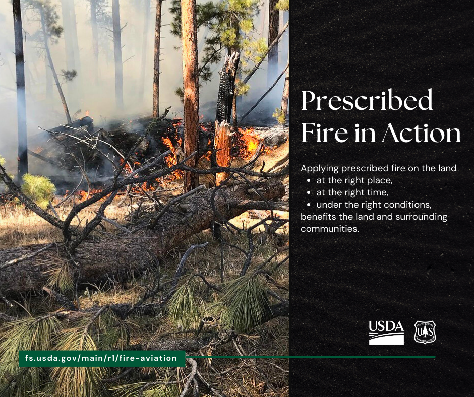
Applying prescribed fire on the land at the right place, at the right time, under the right conditions benefits the land and the surrounding communities.
Prescribed fires are only implemented under the right conditions. Favorable conditions include correct temperature, wind, fuel moisture and ventilation for smoke. When these criteria are met, firefighters implement, monitor, and patrol each burn to ensure it meets forest health and public safety goals including air quality.

Ignitions Completed More Planned this Week
Related Incident:
Publication Type: News
Oct. 29, 2023—Fire crews completed ignitions on 45 acres of piles within the Taos Ski Valley resort area today. Snow flurries occurred throughout the day as fire consumed piles and wet ground limited it from spreading across the forest floor.
Crew members traversed steep slopes with drip torches, lighting piles mostly created from trees felled during the December 2021 snow squall. Other downed and piled trees and branches are the result of hazard tree mitigation and trail development.
Fire qualified staff from Taos Ski Valley joined crew members from Village of Taos Ski Valley Fire Dept., Red River Fire Dept., Latir Volunteer Fire Department, Taos County Fire Dept. and Carson National Forest.
With 163 acres remaining, fire managers plan to continue the operation on Monday and into the week, as weather and conditions allow.
Piles visible along Highway 150 and the Wheeler Peak Trail are slated for burning this winter. They were created from 300 acres of thinning as part of the Highway 150 Corridor Wildland Urban Interface Project.
Both projects are in the Enchanted Circle Landscape and support efforts of the Wildfire Crisis Strategy.
Crews Begin Ignitions
Related Incident:
Publication Type: News
Oct. 29, 2023—After a successful test burn, crews began ignitions on piles throughout the resort area at 10:55 a.m. Light snow has been falling since about 10:00 a.m.
The piles are located in the lower frontside, lower frontside steeps, Minnesota’s and parts of the backside of the resort. They represent 208 acres of fuels reduction, mostly blowdown from the December 2021 snow squall. Other piles were created from hazard tree mitigation and trail development.
With lower ventilation rates forecasted, crews plan to light a portion of the piles to limit smoke impacts today. Ignitions on remaining piles will continue on subsequent days as conditions allow.
Piles currently visible along Highway 150 and the Wheeler Peak Trail are slated for burning this winter. They were created from 300 acres of thinning as part of the Highway 150 Corridor Wildland Urban Interface Project.
Both projects are in the Enchanted Circle Landscape and support efforts of the Wildfire Crisis Strategy.
Saint Charles Daily Update 10292023
Related Incident: Saint Charles Fire
Publication Type: News
Saint Charles Fire Update
Sunday, October 29, 2023 – 9:00 a.m.
Rocky Mountain Complex Incident Management Team 1
Dan Dallas, Incident Commander
Information Phone: 970-628-0130
Email: 2023.saintcharles@firenet.gov
Information Staffing Hours: 8 a.m. to 8 p.m.
Current Situation: The Saint Charles Fire is currently 456 acres and 15% contained. Firefighters have completed construction of containment lines around the entire perimeter of the Saint Charles Fire. Although the area is expected to receive significant snowfall today, this does not mean that the fire is out. These firelines will need to be improved and mopped up before full containment is achieved.
Firefighters will be kept off the line until 11 am today as fire managers monitor weather conditions. At 11 am, the Incident Management Team will brief firefighters on the plan for the remainder of the shift. It is likely that firefighters will not be sent to the line today but will use this time to catch up on paperwork, conduct crew training, and rehabilitate hand tools.
Weather, Fuels, and Fire Behavior: A cold front moved over the fire area yesterday causing a sharp drop in temperatures falling into the 30s during the afternoon. Last night into today, easterly winds will bring a blast of winter weather with several inches of snow expected as temperatures fall even lower. A Winter Storm Warning is in effect until 6 pm today with 8 – 12 inches of snow predicted in the fire area. Temperatures will likely not lift out of the teens with the steadiest period of snow during the morning hours. High pressure will bring an extended period of dry weather next week with mostly sunny skies following the winter blast.
Evacuations, Closures, and Fire Restrictions: Simonson Meadows in Pueblo County and Aspen Acres, Tara J, and the San Isabel area in Custer County remain on pre-evacuation notice. To sign up for emergency alerts please visit https://www.custercounty-co.gov/ (Custer County) or https://www.pueblosheriff.com/242/Emergency-Telephone-Notification (Pueblo County).
Pueblo County implemented a burn ban on October 24, 2023. More information can be found at https://www.pueblosheriff.com/162/Emergency-Management. Custer County initiated Stage 1 fire restrictions on October 24, 2023. More information can be found at https://www.custercounty-co.gov/.
An Area Closure is in place for the fire area on the San Carlos Ranger District of the Pike-San Isabel National Forests & Cimarron and Comanche National Grasslands (PSICC). For additional information, visit: https://www.fs.usda.gov/alerts/psicc/alerts-notices.
Wildfires are a no-fly zone for unauthorized aircraft, including drones. If you fly, we can’t. For more information, visit http://knowbeforeyoufly.org.
Fire Statistics:
Size: 456 acres
Containment: 15%
Total Personnel: 381
Location: 7 Miles SW of Beulah, CO
Reported: October 14, 2023
Cause: lightning
For More Information:
Information Phone: 970-628-0130 (public)
719-470-0459 (media)
Email: 2023.saintcharles@firenet.gov
InciWeb: https://inciweb.nwcg.gov/incident-information/copsf-saint-charles-fire
Facebook: www.facebook.com/SaintCharlesFire
YouTube: https://www.youtube.com/@SaintCharlesFireInformation
Interactive Map: https://tinyurl.com/SaintCharlesFireInteractiveMap
Text Alerts: Text SaintCharlesFire to 77295. Text and data rates apply.