
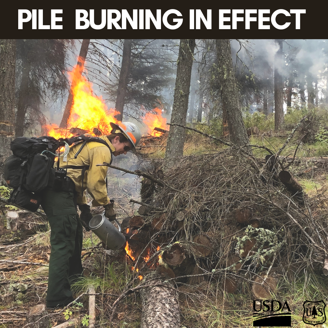
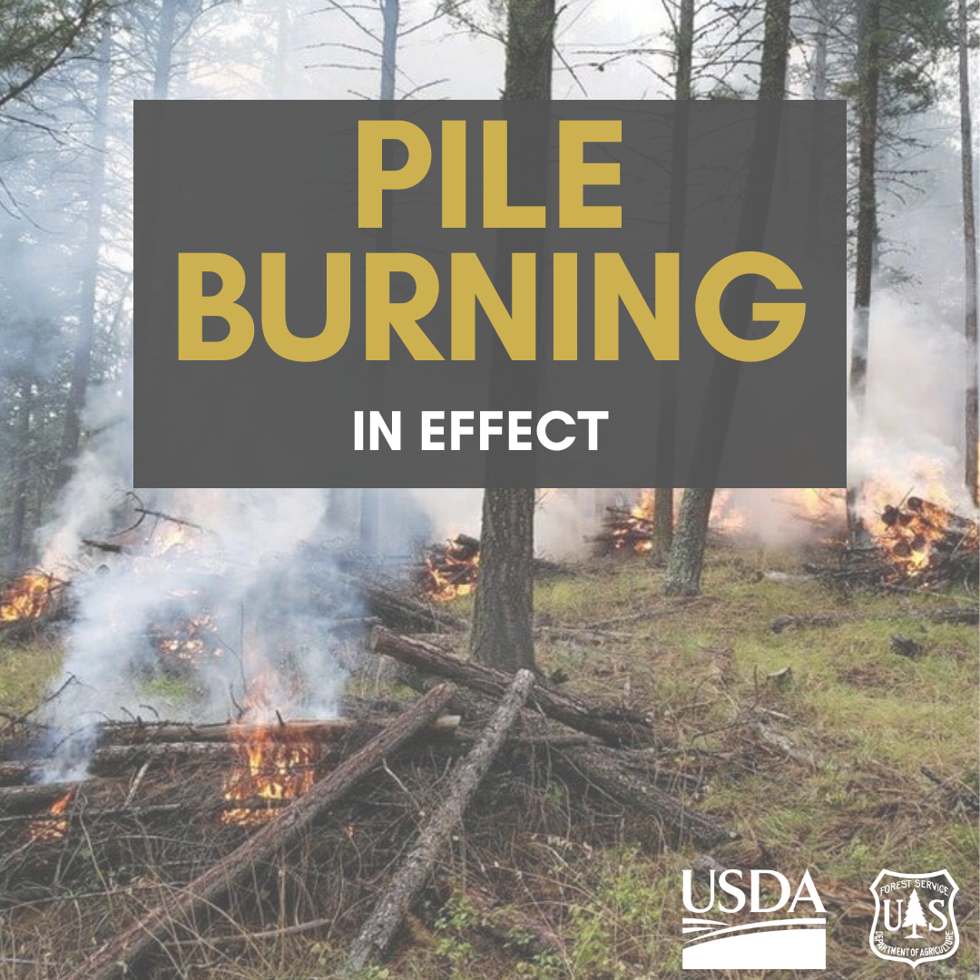
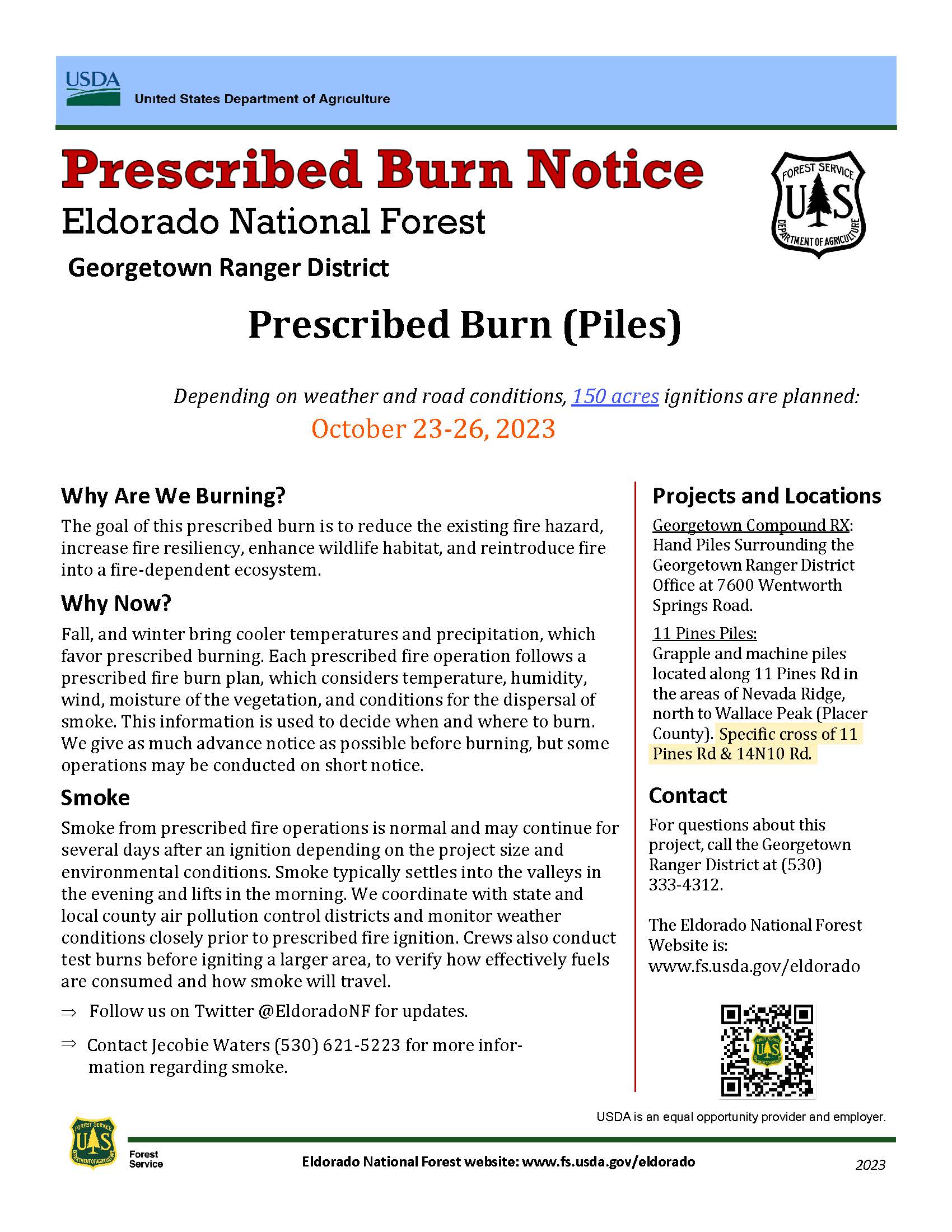
Georgetown Pile Burns
Related Incident:
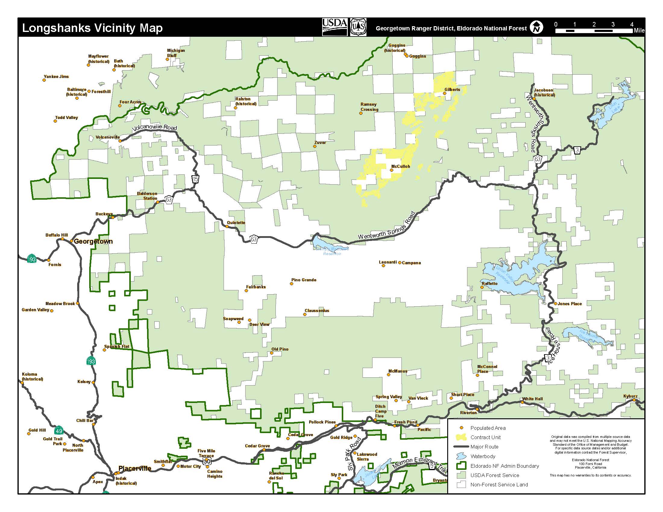
Publication Type: News
Taking advantage of favorable weather conditions and upcoming precipitation the Georgetown Ranger district has planned prescribed pile burning operations until Thursday October 26th. Fire crews will be treating 20 acres of hand piles at the Georgetown district office and 102 acres in the King Fire scar and Rubicon area.
With all fire comes smoke, and the U.S. Forest Service works to mitigate smoke impacts from prescribed fires on the communities in the area. While smoke may be visible in the area during the prescribed fire operation, individuals with respiratory issues or sensitive conditions should take precautions to avoid exposure to smoke. Smoke from prescribed fire operations is normal and may continue for several days after an ignition depending on the project size, conditions, and weather.
Prescribed fire smoke is generally less intense and of much shorter duration than smoke produced by unwanted wildfires. Fire managers consider optimal conditions for dispersal and duration of smoke impacts when planning prescribed burns.
The Eldorado Nation Forest will provide updates and information about the prescribed fire operation to the public as needed.
Please visit the InciWeb page for updates.
Trail Springs and Mill Creek 2 Fire Update October 25 2023
Related Incident: Trail Springs Fire
Publication Type: News
Update: October 25, 2023
Type 3 Team, Incident Commander Pat Seekins
130 Personnel
Overview:
The Trail Springs Fire grew only slightly yesterday and fire crews made good progress working both to contain part of the fire and to prepare other areas for containment in the coming days. To that end, firefighters are preparing to do firing operations that could begin as early as this afternoon. A new closure order has been put into effect, covering multiple roads and trails in and near the Trail Springs Fire area.
Trail Springs Fire | Size:749 Acres | Containment: 0% | Cause: Lightning
Yesterday firefighters directly engaged a portion of the northeast edge of the fire. Water drops from helicopters helped cool the fire’s edge, allowing handcrews to get in close to construct fireline.
Other firefighters were busy clearing and widening designated areas in preparation for strategic firing operations. Their work involved digging line, cutting down hazard trees, limbing healthy trees and removing debris. The control line they are developing will help anchor firing operations. If conditions are favorable, firing operations may begin as early as this afternoon. The goal is to create containment line by burning out grasses, brush and wood debris, which takes the fuel away from the fire.
Mill Creek 2 Fire |Size: 118 Acres | Containment: 0% | Cause: Undetermined
The Mill Creek 2 Fire continues to show very limited fire activity. It is caught up in a high, steep, rocky area without access to substantial fuels. Because of the extremely difficult access and firefighter risk, firefighters are not being sent in to engage the fire. No homes, ranches or private holdings are at risk. Firefighters continue to closely watch fire behavior and assess potential control options should the fire move to lower ground.
Weather: High temps around 60, relative humidity around 30% and light winds out of the southwest.
San Juan NF Temporary Closures: An Area Closure is in place as of 10/24, covering multiple roads and trails in or near the Trail Springs Fire area. That includes NFS Roads 629.B, 629B1, and 620) Details of the closure are on the Trail Springs Fire InciWeb site (link is below).
Temporary Flight Restrictions (TFRs): A TFR is in effect over the Trail Springs Fire area. Details here: https://tfr.faa.gov/save_pages/detail_3_8962.html#areas
Fire Information Phone: 970-426-5370
Facebook:
https://www.facebook.com/sanjuannationalforest
InciWeb: https://inciweb.nwcg.gov/incident-information/cosjf-trail-springs-fire
InciWeb: https://inciweb.nwcg.gov/incident-information/cosjf-mill-creek-2-fire
Trail Springs and Mill Creek 2 Fire Update October 25 2023
Related Incident: Trail Springs Fire
Publication Type: News
Update: October 25, 2023
Type 3 Team, Incident Commander Pat Seekins
130 Personnel
Overview:
The Trail Springs Fire grew only slightly yesterday and fire crews made good progress working both to contain part of the fire and to prepare other areas for containment in the coming days. To that end, firefighters are preparing to do firing operations that could begin as early as this afternoon. A new closure order has been put into effect, covering multiple roads and trails in and near the Trail Springs Fire area.
Trail Springs Fire | Size:749 Acres | Containment: 0% | Cause: Lightning
Yesterday firefighters directly engaged a portion of the northeast edge of the fire. Water drops from helicopters helped cool the fire’s edge, allowing handcrews to get in close to construct fireline.
Other firefighters were busy clearing and widening designated areas in preparation for strategic firing operations. Their work involved digging line, cutting down hazard trees, limbing healthy trees and removing debris. The control line they are developing will help anchor firing operations. If conditions are favorable, firing operations may begin as early as this afternoon. The goal is to create containment line by burning out grasses, brush and wood debris, which takes the fuel away from the fire.
Mill Creek 2 Fire | Size:118 Acres | Containment: 0% | Cause: Under Investigation
The Mill Creek 2 Fire continues to show very limited fire activity. It is caught up in a high, steep, rocky area without access to substantial fuels. Because of the extremely difficult access and firefighter risk, firefighters are not being sent in to engage the fire. No homes, ranches or private holdings are at risk. Firefighters continue to closely watch fire behavior and assess potential control options should the fire move to lower ground.
Weather: High temps around 60, relative humidity around 30% and light winds out of the southwest.
San Juan NF Temporary Closures: An Area Closure is in place as of 10/24, covering multiple roads and trails in or near the Trail Springs Fire area. That includes NFS Roads 629.B, 629B1, and 620) Details of the closure are on the Trail Springs Fire InciWeb site (link is below).
Temporary Flight Restrictions (TFRs): A TFR is in effect over the Trail Springs Fire area. Details here: https://tfr.faa.gov/save_pages/detail_3_8962.html#areas
Fire Information Phone: 970-426-5370
Facebook:
https://www.facebook.com/sanjuannationalforest
InciWeb: https://inciweb.nwcg.gov/incident-information/cosjf-trail-springs-fir
InciWeb: https://inciweb.nwcg.gov/incident-information/cosjf-mill-creek-2-fire
Settings - change map background and toggle additional layers
Filter - control incident types displayed on map.
Zoom to your location
Reset map zoom and position
Could not determine your location.
Show Legend
 Wildfire
 Prescribed Fire
 Burned Area
Response
Burned Area
Response Other
Other
Saint Charles Fire
Unit Information
Incident Contacts
October 25 2023 Prescribed Fire Update
Related Incident: Lolo National Forest Prescribed Fire Operations
Publication Type: Announcement
Pile burning will continue today across all five districts on the Lolo National Forest. Pile burning reduces the amount of fuels that are available to burn, lowering a wildfire’s intensity and reducing risks to firefighters and communities, a key component of the Wildfire Crisis Strategy.
Missoula Ranger District: Firefighters will conduct approximately 75 acres total on three pile burn units on the Missoula Ranger District. Pending conditions, the pile burning will take place on the west side of Marshall Canyon, north of Highway 200 along Lower Blackfoot Corridor, and 2 miles northwest of Lolo Hotsprings. Smoke may be visible from the Missoula, Bonner, parts of the I-90, Highway 12 and Highway 200 Corridors.
Ninemile Ranger District: Firefighters will burn up to 10 acres of landing piles located 3 miles west of the Tarkio, south of Interstate 90. The Ninemile District also plans to burn up to 26 acres of hand piles 4 miles northwest of Alberton. Smoke may be visible from the Ninemile Valley, Alberton and Interstate 90.
Plains/Thompson Falls Ranger District: The Plains/Thompson Falls District will conduct pile burning on two different units located 3 miles north of Thompson Falls and 7 miles northwest of Plains. Smoke may be visible from Thompson Falls and Plains.
Superior Ranger District: Firefighters on the Superior District will conduct pile burning 7 miles east of St. Regis. Smoke may be visible from Interstate 90 and St. Regis.
Seeley Lake Ranger District: The 5-acre pile burn will occur at 4 miles west of the summit on Highway 83 north of Seeley Lake. Smoke could be visible from Highway 200 and Ovando.

REVISED San Juan National Forest Area Closure Order for Trail Springs Fire 11723
Related Incident: Trail Springs Fire
Publication Type: Closures
Please download the complete closure order and map (below) for complete details and exemptions.
Pursuant to 16 U.S.C. § 551 and 36 C.F.R. § 261.50 (a) and (b), the following are prohibited on the National Forest System (NFS) lands, road, and trails in the Pagosa Ranger District, San Juan National Forest, described below and shown on the attached map incorporated into this Order as Exhibit A (the “Described Area, Road, and Trails”):
- Going into or being upon the Described Area.36C.F.R.§261.52(e).
- Being on the Described Roads. 36 C.F.R. § 261.54(e).
- Being on the Described Trails.36C.F.R.§261.55(a).
The closure area is described as beginning at the intersection of the East Monument Road (NFS Road 630) and Turkey Springs Road (NFS Road 629), extending south along Turkey Springs Road (NFS Road 629) but excluding the road itself (which will remain open) to its intersection with Snow Ranch Road (NFS Road 628); then, extending west along Snow Ranch Road (NFS 628) but excluding the road itself (which will remain open) to its intersection with Snow Ranch Trail (NFS Trail 704); then extending north on Snow Ranch Trail (NFS Trail 704) to its intersection with Snow Springs Trail (NFS Trail 605); then, extending north on Snow Springs Trail (NFS 605) to its intersection with Devil
Mountain Trail (NFS Trail 600); then, extending north and east on Devil Mountain Trail (NFS 600) to its intersection with the private property boundary; then, extending east along the private property boundary to its intersection with East Monument Road (NFS Road 630); then extending southeast to its intersection with Turkey Springs Road (NFS 629).
Settings - change map background and toggle additional layers
Filter - control incident types displayed on map.
Zoom to your location
Reset map zoom and position
Could not determine your location.
Show Legend
- Wildfire
- Prescribed Fire
- Burned Area
Response
- Other
H&H Complex
Unit Information
Incident Contacts
Oct 24 Update Biggie Underburn
Related Incident: Biggie Underburn - Phase 1
Publication Type: Announcement
45 acres completed over the weekend. Additional ignitions on hold due to precipitation. Resources currently working to mop up.
Trail Springs and Mill Creek 2 Fire Update October 24 2023
Related Incident: Trail Springs FireMill Creek 2 Fire
Publication Type: News
Trail Springs and Mill Creek 2 Fires
Update: October 24, 2023
Type 3 Team, Incident Commander Pat Seekins
95 Personnel
Overview:
The Trail Springs Fire continued to grow to the east and north yesterday, while additional firefighting crews have arrived to help implement an indirect control strategy designed to contain the fire. Fire activity has decreased significantly on the Mill Creek 2 Fire. There is chance rain over the fire areas on Tuesday.
Trail Springs Fire | Size:720 Acres | Containment: 0% | Cause: Lightning
The fire grew steadily yesterday across terrain flanking to the east and north from West Devil Creek. It is now 720 acres. Crews yesterday constructed indirect fireline yesterday as part of a strategy designed to control fire in places that show the highest probability of success, while minimizing risks to firefighters. A Chinook helicopter delivered water drops to help keep the fire’s western edge from crossing West Devil Creek.
Today firefighters will continue to develop fireline, while looking for opportunities to engage the fire. There is a chance of rainfall, which would reduce fire activity.
Mill Creek 2 Fire |Size: 117 Acres | Containment: 0% | Cause: Undetermined
The Mill Creek 2 Fire has lost much of its intensity over the last two days. The fire is located in steep, rugged terrain about 10 miles northeast of Pagosa Springs. It had been producing significant smoke as it burned through a large section of heavy dead and down trees, but the fire has run into rocky areas without significant fuels.
Because of the extremely difficult access and firefighter risk, firefighters are not being sent in to engage the fire. No homes, ranches or private holdings are at risk. Firefighters continue to closely watch fire behavior and assess potential control options should the fire move to lower ground.
Weather:
There is a chance of scattered showers and thunderstorms over the fire areas today. Temperatures will be around 60 degrees. Light winds out of the west early, shifting to sw winds with potential erratic gusts near any thunderstorms.
San Juan NF Temporary Closures: On the Trail Springs Fire, FS 630 (East Monument) is closed to the public due to increased fire activity and the need to allow access for firefighting apparatus. A full description of road and trail closures can be found under the closures tab of this website.
Temporary Flight Restrictions (TFRs): A TFR is in effect over the Trail Springs Fire area. Details here: https://tfr.faa.gov/save_pages/detail_3_8962.html#areas
October 24 2023 Prescribed Fire Update
Related Incident: Lolo National Forest Prescribed Fire Operations
Publication Type: Announcement
Yesterday was a successful day of prescribed fire operations (pile burning) across the forest, work will continue today. Burning piles reduces hazardous fuels and contributes to the implementation of the Wildfire Crisis Strategy.
Missoula Ranger District: Firefighters will conduct up to 20 acres of hand pile burning on three units on the Missoula Ranger District. Pending conditions, the pile burning will take place on the west side of Marshall Canyon, north of Highway 200 along Lower Blackfoot Corridor, and north of Highway 12 in the Howard Creek drainage off Hwy 12. Smoke may be visible from the Missoula, Bonner, parts of the I-90, Highway 12, and Highway 200 Corridors.
Ninemile Ranger District: Firefighters will burn up to 9 acres of landing piles located 3 miles west of the Tarkio, south of Interstate 90. The Ninemile District also plans to burn up to 50 acres of hand piles 2 miles south of the district office. Smoke may be visible from the Ninemile Valley, Alberton and Interstate 90.
Plains/Thompson Falls Ranger District: Firefighters will be burning several piles located 12 miles northwest of Plains and 10 miles northwest of Thompson Falls. Smoke may be visible from Plains and Thompson Falls.
Superior Ranger District: The Superior District will conduct pile burning on two different units located 6 miles north of Cabin City and 8 miles northeast of St. Regis. Smoke may be visible from Interstate 90 and St. Regis.
Seeley Lake Ranger District: The 10-acre pile burn will occur at the Monture Guard Station, north of Ovando. Smoke could be visible from Highway 200 and Ovando.
