
October 27 2023 Pile Burn Update
Related Incident: Lolo National Forest Prescribed Fire Operations
Publication Type: Announcement
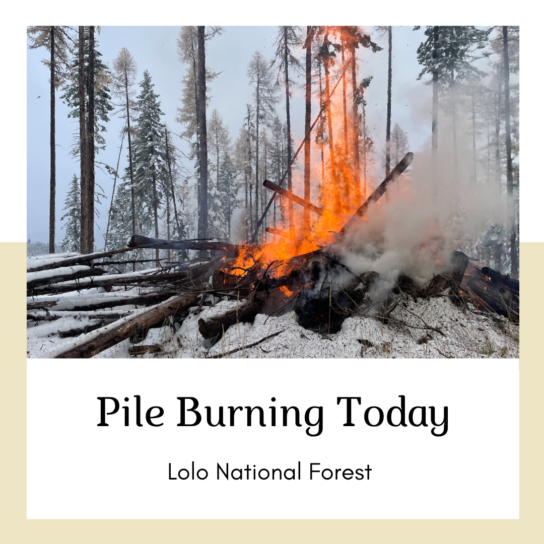
Pile burning efforts will continue today on the Missoula, Ninemile, and Superior Ranger Districts to reduce hazardous fuels from previous vegetation management operations.
Missoula Ranger District: Firefighters will conduct up to 10 acres of pile burning located west of Lolo Hot Springs, north of Highway 12. Smoke may be visible from Highway 12.
Ninemile Ranger District: Firefighters will burn up to 22 acres of piles located 5.5 miles west of the Ninemile District Office, and 4 miles northwest of Alberton. Smoke may be visible from the Ninemile Valley, Alberton and Interstate 90.
Superior Ranger District: Firefighters will initiate pile burning operations 5 miles northeast of Superior. Smoke may be visible from Superior and I-90.
Fuel moisture, wind, temperature, and ventilation for smoke are all considered before beginning a pile burn. Smoke and flames are often visible and are a normal part of pile burning operations. Snow helps contain the piles and firefighters monitor the area during and after the burn.

Trail Springs and Mill Creek 2 Fire Update October 26 2023
Related Incident: Mill Creek 2 Fire
Publication Type: News
Update: October 26, 2023
Type 3 Team, Incident Commander Scott Bovey, 139 Personnel
Overview:
Firefighters worked both directly and indirectly to contain the Trail Springs Fire Wednesday – using hand tools, fire engines, drip torches, and helicopters. Although the fire did continue to grow to the east, much of the smoke visible Wednesday was from strategic firing – fighting fire with fire. That work will continue today, conditions permitting. Minimal fire activity occurred on the Mill Creek2 Fire for the second day in a row.
Trail Springs Fire | Size:871 Acres | Containment: 0% | Cause: Lightning
Using drip torches on the ground and a helicopter, firefighters carefully “burned out” an area between previously prepared containment lines (roads and trails) and the burn scar left by this summer’s Chris Mountain Fire. This is being done to block the potential of additional fire spread to the northeast, towards private property. At the same time, other crews worked directly along the fire’s edge further north to contain the fire in that area. Both those operations are expected to continue today.
On the southern end of the fire along the West Fork of Devil Creek, a heavy lift helicopter used water drops to cool fire activity and prevent the fire from crossing to the west side of the creek. An infrared mapping flight over the fire last night shows the fire grew by about 120 acres in the 24 hours since the last flight. That figure includes both natural growth and the fire put on the ground by aerial and ground personnel.
Mill Creek 2 Fire |Size: 118 Acres | Containment: 0% | Cause: Under Investigation
Though it is not out, the Mill Creek 2 Fire has shown little activity in the past several days. The fire ran uphill until it ran out of fuel and hit natural barriers, including a rock scree field. The fire is being watched, both by air and on the ground, and firefighters will take action if appropriate and is necessary to protect values.
Weather: High temperatures of 57- 60, with winds out of the southwest with gusts approaching 15mph.
San Juan NF Temporary Closures: An area closure is in place as of 10/24, covering some roads and trails in or near the Trail Springs Fire area. These include NFS Roads 630, 629.B, 629B1, and 620. Details of the closure are on the Trail Springs Fire InciWeb page (link below).
Temporary Flight Restrictions (TFRs): A TFR is in effect over the Trail Springs Fire area. Details here: https://tfr.faa.gov/save_pages/detail_3_8962.html#areas
Fire Information Phone: 970-426-5370 (8 a.m. to 8 p.m.)
HH Complex Daily Update October 26
Related Incident: H&H Complex
Publication Type: News
H&H Complex Daily Update, October 26
9:00 PM
- Size: 10,559 acres
- Containment: 95% -North Fire, 100% South Fire
- Start Date: October 24, 2023
Fire Summary
On October 24th, Texas A&M Forest Service received a request for assistance for multiple fires off State Highway 73 and State Highway 87, approximately 7 miles west of Port Arthur, Texas. The fires were actively burning in a marsh grassland during initial response. In coordination with local fire departments, crews from Texas A&M Forest Service, Texas Parks and Wildlife Department, Texas Division of Emergency Management, Jefferson County EMC, and U.S. Fish and Wildlife Service as well as several aviation resources responded to the incident.
Availability to use of heavy equipment is limited, as the majority of the fire perimeter is not stable enough for bulldozers, due to swampy conditions. A marsh-master from U.S. Fish and Wildlife Service assisted with access to the fire's edge. Multiple pieces of aviation were ordered during the first day and provided support to slow forward progression on both the North Fire (just south of HWY 73 west of Port Arthur) and South Fire (north of HWY 87 west of Sabine Pass) that make up the complex. Local fire crews initially focused on structure protection on a limited number of homes and outbuildings in the area of the South Fire.
Yesterday Afternoon and Today
Small decrease in acreage is due to accurate mapping of fire perimeters.
Reconnaissance flights from yesterday showed no smoke heat on the perimeter of the North Fire, and remained unstaffed by ground personnel.
Crews completed conducting mop up operations on the South Fire yesterday evening and were released. The South Fire was not staffed by Texas A&M Forest Service personnel today. It will continue to be monitored by local resources through the weekend. Jefferson County Office of Emergency Management plans to conduct a reconnaissance flight on October 30 to make final judgements on containment.
Closures
There are no road closures currently. Any information on road accessibility in the area can be found on www.drivetexas.org
Smith River Complex PostFire BAER Assessment Summary Released
Related Incident: Smith River Complex Post-Fire BAER
Publication Type: Announcement
Smith River Complex Post-Fire BAER Assessment Summary Released
Attached below under Related Information is a summary (PDF document) of the Six Rivers National Forest's Burned Area Emergency Response (BAER) team's post-fire assessment of the Smith River Complex burned areas.
Trail Springs and Mill Creek 2 Fire Update October 26 2023
Related Incident: Trail Springs Fire
Publication Type: News
Update: October 26, 2023
Type 3 Team, Incident Commander Scott Bovey, 139 Personnel
Overview:
Firefighters worked both directly and indirectly to contain the Trail Springs Fire Wednesday – using hand tools, fire engines, drip torches, and helicopters. Although the fire did continue to grow to the east, much of the smoke visible Wednesday was from strategic firing – fighting fire with fire. That work will continue today, conditions permitting. Minimal fire activity occurred on the Mill Creek2 Fire for the second day in a row.
Trail Springs Fire | Size:871 Acres | Containment: 0% | Cause: Lightning
Using drip torches on the ground and a helicopter, firefighters carefully “burned out” an area between previously prepared containment lines (roads and trails) and the burn scar left by this summer’s Chris Mountain Fire. This is being done to block the potential of additional fire spread to the northeast, towards private property. At the same time, other crews worked directly along the fire’s edge further north to contain the fire in that area. Both those operations are expected to continue today.
On the southern end of the fire along the West Fork of Devil Creek, a heavy lift helicopter used water drops to cool fire activity and prevent the fire from crossing to the west side of the creek. An infrared mapping flight over the fire last night shows the fire grew by about 120 acres in the 24 hours since the last flight. That figure includes both natural growth and the fire put on the ground by aerial and ground personnel.
Mill Creek 2 Fire |Size: 118 Acres | Containment: 0% | Cause: Under Investigation
Though it is not out, the Mill Creek 2 Fire has shown little activity in the past several days. The fire ran uphill until it ran out of fuel and hit natural barriers, including a rock scree field. The fire is being watched, both by air and on the ground, but no suppression activities are planned.
Weather: High temperatures of 57- 60, with winds out of the southwest with gusts approaching 15mph.
San Juan NF Temporary Closures: An area closure is in place as of 10/24, covering some roads and trails in or near the Trail Springs Fire area. These include NFS Roads 630, 629.B, 629B1, and 620. Details of the closure are on the Trail Springs Fire InciWeb page (link below).
Temporary Flight Restrictions (TFRs): A TFR is in effect over the Trail Springs Fire area. Details here: https://tfr.faa.gov/save_pages/detail_3_8962.html#areas
Fire Information Phone: 970-426-5370 (8 a.m. to 8 p.m.)
October 26 2023 Prescribed Fire Update
Related Incident: Lolo National Forest Prescribed Fire Operations
Publication Type: Announcement
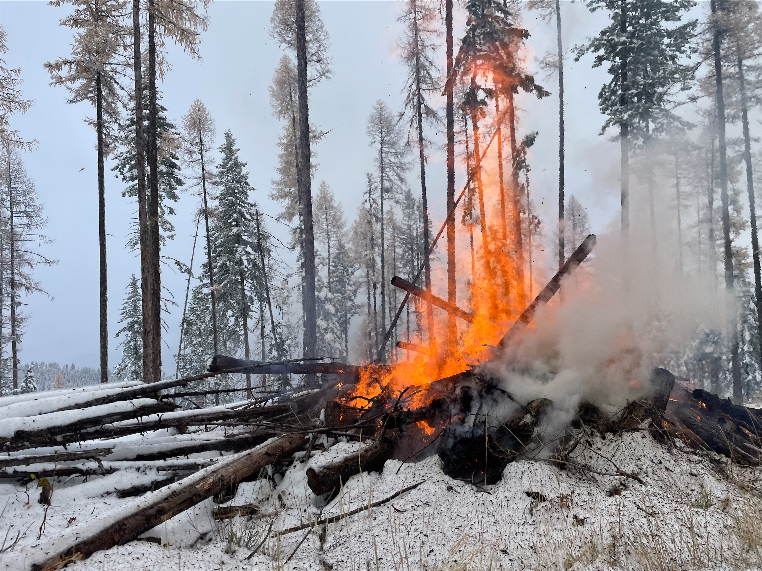
Pending conditions, the Superior Ranger District is planning to conduct pile burns today to reduce hazardous fuels from previous vegetation management operations.
Superior Ranger District: Firefighters on the Superior District will conduct pile burning 5 miles northeast of Superior. Smoke may be visible from Superior and I-90.
Anvil Fire Updated Closure Order 0610282368
Related Incident: Anvil Fire
Publication Type: Closures
Powers, Ore – October 25, 2023 Rogue River-Siskiyou National Forest Acting Forest Supervisor Jake Winn has signed an order that reduces the Emergency Area and Road Closure for the Anvil Fire. This reduction of the closure area is effective October 25, 2023 through July 1, 2024 unless rescinded sooner.
The area closure now includes:
- The entirety of the Grassy Knob Wilderness
The road closure includes:
- FSR 5201 (Sixes River Road) from the junction of FSR 5325 (Elk River Road) to the junction of
- FSR 5201-390 (Butler Creek Road)
The trail closure includes
- Trail # 1241 – Grassy Knob Trail
See attached PDF for map and details.
HH Complex Daily Update October 25
Related Incident: H&H Complex
Publication Type: News
H&H Complex Daily Update, October 25
1:30 PM
- Size: 11,200 acres
- Containment: 60%
- Start Date: October 24, 2023
Fire Summary
On October 24th, Texas A&M Forest Service received a request for assistance for multiple fires off State Highway 73 and State Highway 87, approximately 7 miles west of Port Arthur, Texas. The fires were actively burning in a marsh grassland during initial response. In coordination with local fire departments, crews from Texas A&M Forest Service, Texas Parks and Wildlife Department, Texas Division of Emergency Management, Jefferson County EMC, and U.S. Fish and Wildlife Service as well as several aviation resources responded to the incident.
Use of heavy equipment is limited, as the majority of the fire perimeter is not stable enough for bulldozers, due to swampy conditions. A marsh-master from U.S. Fish and Wildlife Service is assisting with access to the fire's edge. Multiple pieces of aviation were ordered during the first day and provided support to slow forward progression on both the North Fire (just south of HWY 73 west of Port Arthur) and South Fire (north of HWY 87 west of Sabine Pass) that make up the complex. Local fire crews initially focused on structure protection on a limited number of homes and outbuildings in the area of the South Fire.
Today
While neither fire seemed to grow over night, efforts today continue to focus on accurate mapping of the fire perimeters. Access to extremely limited due to terrain conditions.
Reconnaissance flights from this morning show no active flames on the North Fire, but significant heat. A helicopter is supporting suppression activities, making water drops on hot spots that could threaten containment lines.
Crews are patrolling and conducting mop up operations on the South Fire. The perimeter lines have minimal to no heat along the entirety.
Weather
Forecasts show the area will experience mostly clear conditions today, then becoming mostly cloudy this evening with a chance of overnight showers. Temperatures are expected to stay in the mid-70's to low 80's, with minimum relative humidity briefly dipping to 60% midday. Winds remain from the southeast at 9-14 mph, and gusts from 16-20 mph.
Closures
There are no road closures currently. Any information on road accessibility in the area can be found on www.drivetexas.org
Prescribed Fire Updates Oct 25 2023
Related Incident: Mendocino NF Fall 2023/Spring 2024 RX Fire Projects
Publication Type: News
Last week Upper Lake Ranger District completed 24 acres of understory burning at Howard Mill and 50 acres of piles at Pillsbury Homesites, and 4 acres of piles at Westshore. This week district personnel will continue pile burn operations in the Westshore project area, and they are potentially planning to burn 5 acres of piles at Little Doe Campground on Covelo Ranger District. Last week Grindstone District personnel completed 4 acres of pile burning at the Snow Basin Homesites. Plans to burn next week are dependent on weather conditions and resource availability.
Quidazoic Project Pile Burns on Pacific Ranger District
Related Incident:
Publication Type: News
The Pacific Ranger district is planning to begin implementation of pile burning on the Quidazoic Project this week. The Quidazoic project continues to dispose of biomass piles created as part of King Fire Recovery operations. We are hoping to take advantage of favorable weather conditions to burn high elevation piles before accumulation of winter snow.
With all fire comes smoke, and the U.S. Forest Service works to mitigate smoke impacts from prescribed fires on the communities in the area. While smoke may be visible in the area during the prescribed fire operation, individuals with respiratory issues or sensitive conditions should take precautions to avoid exposure to smoke. Smoke from prescribed fire operations is normal and may continue for several days after an ignition depending on the project size, conditions, and weather.
Prescribed fire smoke is generally less intense and of much shorter duration than smoke produced by unwanted wildfires. Fire managers consider optimal conditions for dispersal and duration of smoke impacts when planning prescribed burns.
The Eldorado Nation Forest will provide updates and information about the prescribed fire operation to the public as needed.