
Saint Charles Daily Update 11012023
Related Incident: Saint Charles Fire
Publication Type: News
Saint Charles Fire Update
Wednesday, November 1, 2023 – 9:00 a.m.
Information Phone: 970-628-0130
Email: 2023.saintcharles@firenet.gov
Information Staffing Hours: 8 a.m. to 8 p.m.
Current Situation:
The Saint Charles Fire is 492 acres and 99% contained. Management of the fire has transitioned to a Type 4 incident management team, alongside local forest resources on the Pike-San Isabel National Forests & Cimarron and Comanche National Grasslands (PSICC). Efforts are now focused on fire suppression repair, bringing landscape conditions to what they were prior to the fire.
Access to the fireline is still limited due to icy and muddy conditions on the steep terrain and areas of inaccessibility due to snowpack. Brush chippers are on-scene to disperse piles of slash (cut brush and limbs) created during line-building operations. Chipping crews completed work at the Boy Scout Camp and will begin work in Division K as the snow melts to allow access. Excavators will continue work in the Boy Scout Camp.
When it is safe to do so, heavy equipment will work to redistribute soil that was disturbed during fire suppression operations in Divisions A and D.
Weather and Fire Behavior:
Dry weather and sunny skies are expected this week. A slow warming trend will continue each day over the fire area, with maximum temperatures expected to reach or exceed 50 degrees. This pattern will melt the snowpack, except in shaded areas.
Closures and Fire Restrictions:
An Area Closure is in place for the fire area on the San Carlos Ranger District of the PSICC. For additional information, visit: https://www.fs.usda.gov/alerts/psicc/alerts-notices.
There are currently no fire restrictions in place in Pueblo and Custer Counties.
Wildfires are a no-fly zone for unauthorized aircraft, including drones. If you fly, we can’t. For more information, visit http://knowbeforeyoufly.org.
Fire Statistics:
Size: 492 acres
Containment: 99%
Total Personnel: 257
Location: 7 Miles SW of Beulah, CO
Reported: October 14, 2023
Cause: lightning
For More Information:
Information Phone: 970-628-0130 (public)
Email: 2023.saintcharles@firenet.gov
InciWeb: https://inciweb.nwcg.gov/incident-information/copsf-saint-charles-fire
Facebook: www.facebook.com/SaintCharlesFire
YouTube: https://www.youtube.com/@SaintCharlesFireInformation
Interactive Map: https://tinyurl.com/SaintCharlesFireInteractiveMap
Text Alerts: Text SaintCharlesFire to 77295. Text and data rates apply.
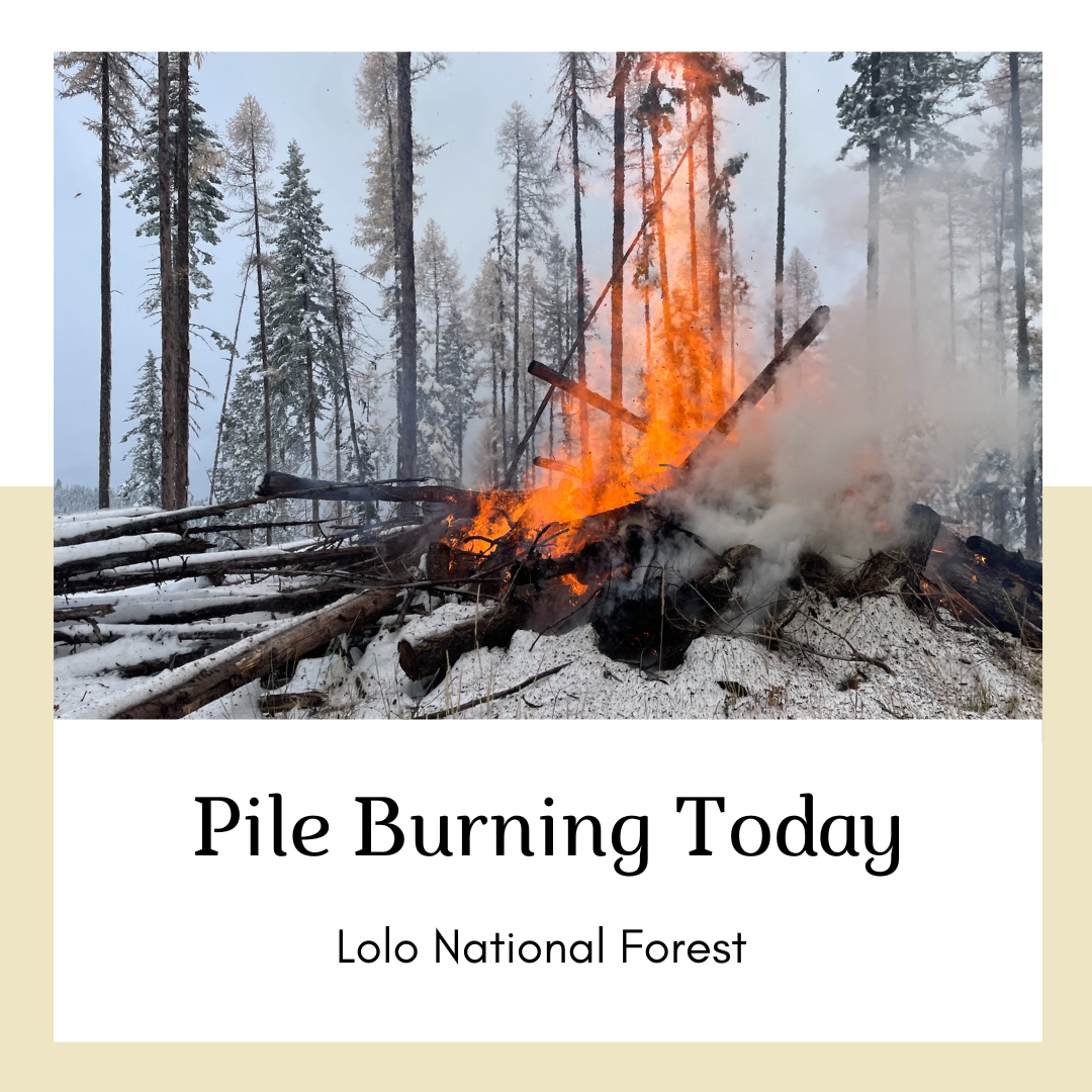
November 1 2023 Pile Burning Update
Related Incident: Lolo National Forest Prescribed Fire Operations
Publication Type: Announcement
Yesterday was a successful day of pile burning across the forest, work will continue today. Burning piles reduces hazardous fuels and contributes to implementing the Wildfire Crisis Strategy.
Missoula Ranger District: Firefighters will burn 10 acres of piles by hand east of Marshall Mountain Ski Resort. Fire crews also plan to burn up to 10 acres of piles one mile northeast of Gold Creek and the Blackfoot River. Smoke may be visible from I-90 along east Missoula, Bonner, and the Blackfoot River corridor.
Ninemile Ranger District: The Ninemile District plans to pile burn, 5 miles northwest of the District Office, between Kennedy Creek and Butler Creek. Smoke may be visible from Alberton and Interstate 90.
Plains/Thompson Falls Ranger District: 25-acre pile burn will occur 7 miles southwest of Plains. Smoke may be visible from Plains.
Superior Ranger District: Firefighters will initiate up to 6 acres of pile burning operations 4 miles northeast of Cabin City and 4 miles northeast of Superior. Smoke may be visible from Interstate 90 and Superior.
VIDEO Burned Area Emergency Response BAER Team Assesses Potential PostFire Effects from Future Rain
Related Incident: 2023 SRF Lightning Complex Post-Fire BAER
Publication Type: Announcement
After large wildfires on National Forests a Burned Area Emergency Response Team assembles to assess damage and potential adverse effects from future rains. We talked with Tom Giambra a soil scientist, and Eric Merten a fish biologist assigned to the Smith River Complex Fire in Northern California, Southern Oregon, about the effects of extreme wildfires and information scientists can provide to help. (See link below to the USDA Forest Service BAER video by Andrew Avitt)
Burned Area Emergency Response (BAER), Soil and Water - YouTube Video:
VIDEO Burned Area Emergency Response BAER Team Assesses Potential PostFire Effects from Future Rain
Related Incident: Smith River Complex Post-Fire BAER
Publication Type: Announcement
After large wildfires on National Forests a Burned Area Emergency Response Team assembles to assess damage and potential adverse effects from future rains. We talked with Tom Giambra a soil scientist, and Eric Merten a fish biologist assigned to the Smith River Complex Fire in Northern California, Southern Oregon, about the effects of extreme wildfires and information scientists can provide to help. (See link below to the USDA Forest Service BAER video by Andrew Avitt)
Burned Area Emergency Response (BAER), Soil and Water - YouTube Video:
Current Pile Burning Activity10 30 2023
Related Incident: Arapaho and Roosevelt National Forests Pile Burning
Publication Type: Announcement
Near the Fair Subdivision, east of Tabernash along Water Board Rd (FSR 128). See map
Fall 2023 Pile Burning Plans for Sulphur Ranger District10 13 2023
Related Incident: Arapaho and Roosevelt National Forests Pile Burning
Publication Type: News
GRANBY, Colo. (Oct. 13, 2023) – U.S. Forest Service firefighters on the Sulphur Ranger District plan to burn slash piles from multiple fuels reduction and hazardous tree removal projects. Burning of these piles could occur this fall, winter and spring as weather and fuel conditions allow on the Arapaho National Forest.
Throughout the year, fuels reduction programs across the forest are ongoing, improving forest health through both hand and mechanical tree cutting. During this process larger logs are taken to market and smaller limbs, saplings and brush are piled together to dry for later burning. When the weather changes in the fall, winter and spring, and more moisture is present in the ecosystem, conditions become favorable for burning these piles. During this time, firefighters return to ignite piles that have been left to cure from thinning projects.
Piles are only ignited under certain conditions, including favorable smoke dispersal and adequate snow cover. These conditions direct firefighters on where within project areas burning can occur due to the localized nature of conditions.
Smoke, flames, and glowing embers are often visible and are a normal part of pile burning operations. Moisture, namely snow, helps contain the piles and firefighters monitor the area during and after the burn. Monitoring continues until the piles are considered out. Public and firefighter safety is always the number one priority in burning operations.
Areas that could be burned as conditions allow include:
- Fair: 15,000 hand piles, 10 machine piles General Location: East of Tabernash along Water Board Rd (FSR 128)
- Snow Mountain: 20 machine piles General Location: West of Snow Mountain Ranch
- Little HO: 20 machine piles General Location: 6 miles east of Granby
- Upper Fraser: 1,000 hand piles General Location: Northwest of Winter Park near Elk Creek Rd
- Big Blue Ridge Machine: 50 machine piles General Location: South of CR55 along the top of Blue Ridge
- Blue Ridge Unit 15: 50 hand piles General Location: West of CR 50 at the Horseshoe Trailhead
- Kawland Unit 90: 20 machine piles, 400 hand piles General Location: Between Vasquez and East Elk Creeks on FSR 159, West of Winter Park Resort
- Bottle Pass: 150 hand piles General Location: Bottle Pass between Ptarmigan and Bottle Peak
Visit the interactive map for more information.
Trail Springs and Mill Creek 2 Fire Update October 31 2023
Related Incident: Trail Springs FireMill Creek 2 Fire
Publication Type: News
Update: October 31, 2023
Type 3 Team, Incident Commander Scott Bovey, 156 Personnel
Trail Springs Fire | Size: 1251 Acres | Containment: 37% | Cause: Lightning
Fire personnel conducted a reconnaissance flight yesterday afternoon to determine how much impact the wet weather over the weekend had on the fires. They observed that the Trail Springs Fire continues to produce smoke from creeping and smoldering fire behavior within its existing footprint. The infrared flight that took place last night showed minimal heat in the bottom of the West Fork of Devil Creek drainage along the creek itself and detected only one acre of growth since the last IR flight. However, areas of scattered heat remain within the fire perimeter and are anticipated to persist until a season-ending weather event occurs. The continuation of active burning after two days of snow, rain, and cold temperatures is telling of how dry the fuels got during the droughty summer months.
Firefighters finished chipping the brush that had been piled along the containment line. Today, they will continue cutting ladder fuels and chipping along East Monument Road north towards Corral Mountain Road to complete the indirect fireline. Depending on soil moisture, crews may begin repairing hand line, as well. Two engines and one fire module working on this fire have also been made available to assist local agencies if there are any new fires that start.
Fire Danger remains Moderate despite recent winter weather, so it is important that forest users completely drown campfires to prevent unintended escape. Use the “drown, stir, feel” method to be sure it's dead out.
Mill Creek 2 Fire |Size: 122 Acres | Containment: 0% | Cause: Under Investigation
Some smoke was observed from the Mill Creek 2 Fire on yesterday’s recon flight, primarily on the northern portion of the fire area. Last night’s infrared flight confirmed heat within the fire perimeter and one acre of growth. No structures or other values are threatened. A fire engine is positioned nearby and ready to respond, if required.
Weather: Today’s weather will be similar to yesterday. Temps will start in the teens in the morning and reach the mid 40’s by afternoon. Wind is expected to remain light but the relative humidity will drop back down to around 25%.
San Juan NF Temporary Closures: An area closure is in place involving roads and trails in or near the Trail Springs Fire area (Middle Mountain area), including Forest Road 630, East Monument Road, at its intersection with Turkey Springs Road. Details of the closure are on the Trail Springs Fire InciWeb page (link and QR code below) and on the “Alerts and Notices” page of the forest website: https://www.fs.usda.gov/alerts/sanjuan/alerts-notices
A Temporary Flight Restriction is in effect: https://tfr.faa.gov/save_pages/detail_3_8962.html#areas
Fire Information: 970-426-5370 (8 a.m. to 8 p.m.) | Facebook: https://www.facebook.com/sanjuannationalforest
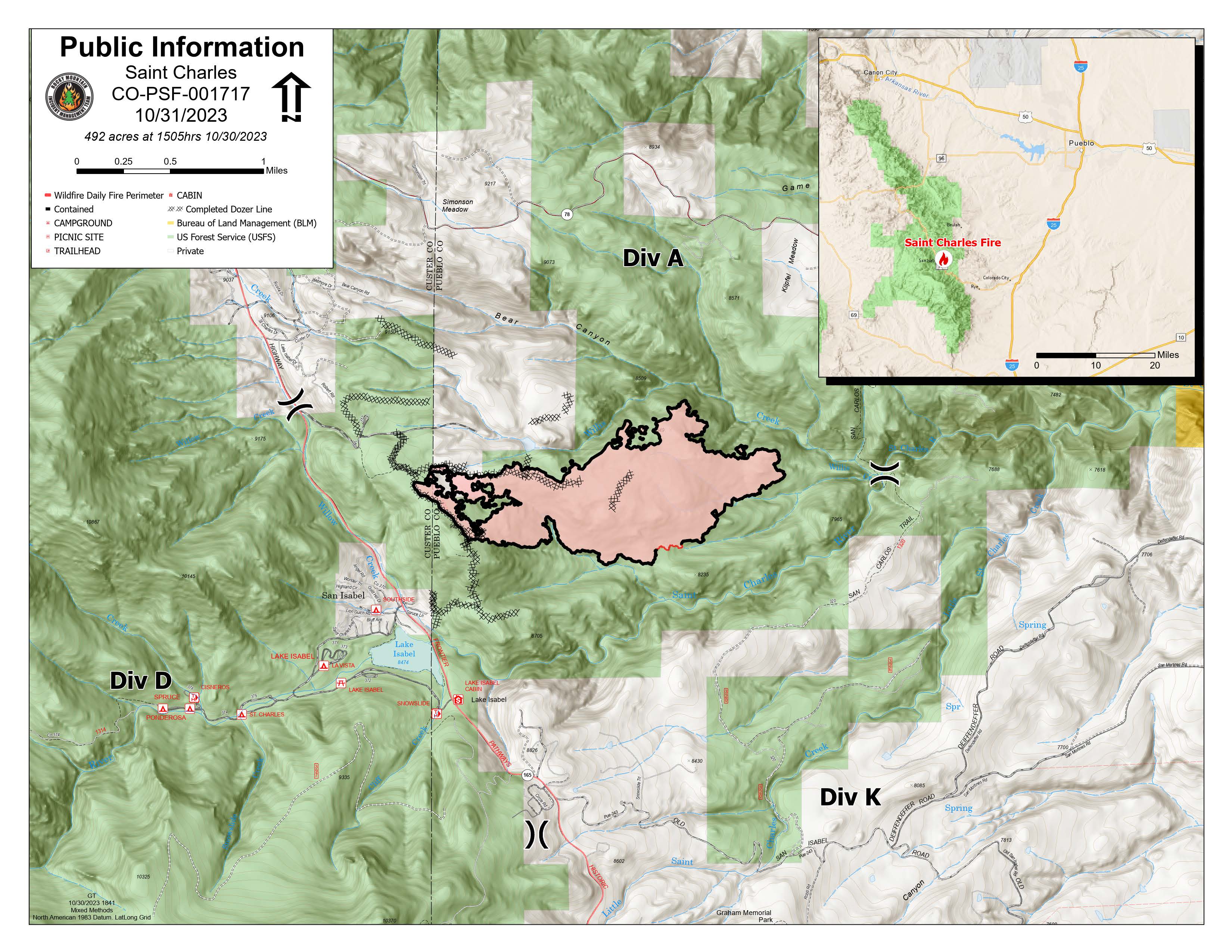
Saint Charles Daily Update 10312023
Related Incident: Saint Charles Fire
Publication Type: News
Saint Charles Fire Update
Tuesday, October 31, 2023 – 9:00 a.m.
Rocky Mountain Complex Incident Management Team 1
Dan Dallas, Incident Commander
Information Phone: 970-628-0130
Email: 2023.saintcharles@firenet.gov
Information Staffing Hours: 8 a.m. to 8 p.m.
Current Situation: The Saint Charles Fire is 492 acres and 99% contained. Rocky Mountain Complex Incident Management Team 1 will be transitioning management of the fire to a local Type 4 incident management team. Some of the current personnel on the fire will continue to help the Type 4 team. Snowy and muddy conditions remain around much of the fire making driving and access difficult.
Firefighters did not return to the line yesterday due to hazardous driving conditions and limited access to the fireline. Equipment retrieval and fire suppression repair activities will resume today. Tasks for today include chipping of the fuels that had been removed during fireline creation in the area of the Scout Camp off Hwy 165. Crews are performing “backhaul”, the packaging and removal of supplies and equipment from the fireline. Necessary firefighting equipment is left in place while items which have served their purpose, such as hoses, and other structure protection supplies, need to be accounted for and removed from the fire area. These backhauled items will be sent back to the cache to be cleaned, inventoried, and restocked for the next fire.
Weather, Fuels, and Fire Behavior: Sunny, with a high near 50. Warmer temperatures and drier conditions are predicted throughout the week. By Friday, the highs for the day are predicted to be above the seasonal average. Heavier fuels and unburned pockets will continue to burn within the perimeter and show occasional smoke.
Closures, and Fire Restrictions: An Area Closure is in place for the fire area on the San Carlos Ranger District of the Pike-San Isabel National Forests & Cimarron and Comanche National Grasslands (PSICC). For additional information, visit: https://www.fs.usda.gov/alerts/psicc/alerts-notices.
Pueblo County implemented a burn ban on October 24, 2023. More information can be found at https://www.pueblosheriff.com/162/Emergency-Management. Custer County initiated Stage 1 fire restrictions on October 24, 2023. More information can be found at https://www.custercounty-co.gov/.
Wildfires are a no-fly zone for unauthorized aircraft, including drones. If you fly, we can’t. For more information, visit http://knowbeforeyoufly.org.
Fire Statistics:
Size: 492 acres
Containment: 99%
Total Personnel: 330
Location: 7 Miles SW of Beulah, CO
Reported: October 14, 2023
Cause: lightning
For More Information: Information Phone: 970-628-0130 (public)
Email: 2023.saintcharles@firenet.gov
InciWeb: https://inciweb.nwcg.gov/incident-information/copsf-saint-charles-fire
Facebook: www.facebook.com/SaintCharlesFire
YouTube: https://www.youtube.com/@SaintCharlesFireInformation
Interactive Map: https://tinyurl.com/SaintCharlesFireInteractiveMap
Text Alerts: Text SaintCharlesFire to 77295. Text and data rates apply.
October 31 2023 Pile Burning Update
Related Incident: Lolo National Forest Prescribed Fire Operations
Publication Type: Announcement
Pile burning will continue today across multiple districts on the Lolo National Forest. Pile burning reduces the amount of fuels that are available to burn, lowering a wildfire’s intensity and reducing risks to firefighters and communities, a key component of the Wildfire Crisis Strategy.
Missoula Ranger District: Firefighters will be burning 70 acres of hand piles in the Howard Creek drainage, north of Highway 12. Smoke may be visible from Highway 12.
Ninemile Ranger District: The Ninemile District plans to pile burn at the Clearwater Crossing Campground located 17 miles southwest of Alberton. Smoke may be visible Interstate 90.
Plains/Thompson Falls Ranger District: 25-acre pile burn will take place 7 miles southeast of Plains. Smoke may be visible from Plains.
Superior Ranger District: Firefighters will initiate up to 6 acres of pile burning operations 4 miles northeast of Cabin City and 5 miles northeast of Superior. Smoke may be visible from Interstate 90 and Superior.
Firefighters will implement, patrol and monitor the pile burning over the next few days.

Lafitte Fire Update October 31 2023
Related Incident: Lafitte
Publication Type: News
National Park Service U.S. Department of the Interior
Jean Lafitte National Historical Park and Preserve
Lafitte Fire Update
October 31, 2023
Fire Information Line – (504) 382-0291
2023.lafitte@firenet.gov
Fulton Jeansonne, Incident Commander
Size: 147 acres | Containment: 60% | Total Personnel: 63 | Location: 0.5 miles north of Jean Lafitte,
1.5 miles north of Barataria | County: Jefferson | Start Date: October 17, 2023 | Cause: Undetermined
Fire Updates will be published every other day.
Special Note- Please help firefighters by following all local regulations. “If you fly, we can’t.” https://www.fs.usda.gov/managing-land/fire/uas/if-you-fly Unauthorized drone flights pose serious risks to firefighter and public safety and disrupt the effectiveness of wildfire suppression operations. Airspace restrictions are called Temporary Flight Restrictions (TFRs) and are communicated to pilots through Notices to Air Missions (NOTAMs). They restrict aircraft (including float planes & drones) from operating without permission in a certain area for a limited time. You must always check NOTAMs prior to your flight. Incursions into the TFR have occurred over the last couple of days. Drone incursions within wildfire areas with active aerial operations create a collision risk and may result in aircraft being grounded until the threat is mitigated. These delays adversely affect the safety and efficiency of the overall firefighting effort.
Jean Lafitte, LA - The Lafitte Fire in the Jean Lafitte National Historical Park and Preserve has not exceeded its October 21st footprint. It is still 147 acres. However, containment has increased to 60% as a result of firefighters’ efforts including tactical saturation of hot spots. Any smoke that is produced by the fire is due to burning within the interior of the fire’s containment lines.
This week- Firefighters have deployed fire hose, set up sprinklers, and erected portable tanks across the fire area in an effort to saturate the ground with fresh water and extinguish the fire. With a thermal imaging capable drone, firefighters are able to precisely identify hot spots and then extinguish them.
Weather- The National Weather Service in New Orleans has issued a Red Flag Warning for Critical Fire Weather Conditions, which is in effect on Tuesday, October 31st from 10am-7pm. Winds are expected to be 10-20 mph with gusts up to 35 mph. Humidity is expected to drop to as low as 20%. Mostly cloudy skies are forecast with a 20% chance for showers in the morning. On Wednesday, a Fire Weather Watch is in effect. The forecast calls for a sunny day with highs on the upper 50s and north winds 15-20 mph with gusts possible up to 40 mph.
Lafitte Fire information link: https://inciweb.nwcg.gov/incident-information/lajep-lafitte
National Park Service information link: https://www.facebook.com/JeanLafitteNPS