
Maid Fire 100 contained
Related Incident:
Publication Type: News
FLAGSTAFF, Ariz., Nov. 13, 2023 — The Maid Fire located just southeast of Interstate 17’s Stoneman Lake exit is 100% contained at 942 acres and may produce very small traces of smoke as leaves and small brush smolder within the fire perimeter on Apache Maid mountain.
An emergency closure order is in place for Apache Maid mountain, which includes Forest Roads 620, 620D, and 644G. This order will be in place through March 30, 2024 unless rescinded earlier. All Forest Orders for Coconino National Forest are posted online on our Forest Orders web page.
Firefighters will continue to patrol the area to ensure the fire remains contained.
The human-caused wildfire was first reported at 5:11 a.m. on November 4 by a member of the public. The specific cause is still under investigation.
Daily Update Monday November 13 2023
Related Incident: 2023 Collett Ridge Fire
Publication Type: Announcement
5,335 acres | 55% containment | 271 personnel assigned
Highlights: Weather continued to play an important role in assisting firefighters in increasing containment on the fire yesterday. A drone was used to conduct aerial reconnaissance to identify heat signatures within the fire area: heat sources from larger smoldering fuels, such as snags, stumps, and dead-and-down trees, were identified well inside the fire perimeter. Hand line work will continue along Polecat Branch to connect with the containment line along the southern edge of the fire. Firefighters will be reducing forest fuels around residences in the Whispering Pines area as a protection measure. Crews continue to patrol the northern, eastern, and southern edges of the fire area and perform mop-up operations, extinguishing any lingering hotspots, as needed.
Facebook: https://www.facebook.com/nfsnc/
Resources assigned to the fire include four 20-person hand crews, Type 4 and 6 Engines; Dozers; and Water Tenders. Three helicopters are also assigned.
Weather & Fire Behavior: High pressure is forecast to nose its way into the area from the northeast today and Tuesday with a period of drying. Temperatures over the next two days are expected to warm into the 60s. It will continue to be rather cool at night with lows in the 30s. Humidity minimums should dip into the 30-45% range today and 25-40% on Tuesday. Wind speeds will increase to 5 to 10 mph today, and 10-15 mph across the ridges tonight. Humidity recovery along the ridges tonight may be poor.
Until sufficient precipitation occurs on the fire, expect areas of isolated smoldering, primarily in heavy woody fuels such as log ends and snags. Timber litter fuels may continue to burn with high relative humidity. Heavy fuel concentrations will retain heat and serve as future heat sources. The primary fire behavior characteristic for the day continues to be isolated smoldering. Smoldering leaf litter may “kindle to flame” with little wind and/or sunshine and burning snags may fall into fresh fuels.
Air Quality: Smoke may occur in nearby communities. Air quality information provided by the North Carolina Department of Environmental Quality is available at airquality.climate.ncsu.edu/.
Burn Bans: Due to increased fire risk, the N.C. Forest Service has issued a ban on all open burning until further notice in several counties in western North Carolina. For more information visit https://www.ncforestservice.gov/fire_control/sit_report.htm
The U.S. Forest Service has implemented fire restrictions across the Pisgah and Nantahala National Forests. To view the closure order visit www.fs.usda.gov/alerts/nfsnc/alerts-notices
Temporary Flight Restriction: A Temporary Flight Restriction (TFR) is in place over the Collett Ridge Fire area. If you fly, we can’t. Aircraft or drone intrusions into the restricted airspace endangers aircrews conducting fire operations and aerial resources are grounded for safety. This unnecessarily places aircrews and ground fire crews at risk in a dynamic and dangerous fire environment.
Closures: For public and firefighter safety the following road and area closures are in effect due to increased fire activity and suppression operations in the area from Big Stamp east to Shinbone Ridge to Signal Bald and a road closure is in effect from the intersection of Little Fires Creek Road, 340B, and Fires Creek Road, 340. The Rim Trail is temporarily closed for approximately 7 miles from Big Stamp to Shinbone.
November 13 2023 Pile Burning Update
Related Incident: Lolo National Forest Prescribed Fire Operations
Publication Type: Announcement
Another day of pile burning will continue today and throughout the week across multiple districts on the Lolo National Forest. Pile burning reduces the amount of fuels that are available to burn, lowering a wildfire’s intensity and reducing risks to firefighters and communities, a key component of the Wildfire Crisis Strategy.
Plains/Thompson Falls Ranger District: The Plains/Thompson Falls District will conduct pile burning on two different units located 7 miles southwest of Plains. Smoke may be visible from Plains.
Superior Ranger District: The Superior District plans to burn approximately 15 acres of piles, 9 miles southeast of Superior and 10 acres of piles in Tamarack Creek, 5 miles northeast of St. Regis. Smoke may be visible from Alberton, St. Regis, and Interstate 90.
Steep Valley Fire November 13th 2023 Update
Related Incident:
Publication Type: News
GLEN JEAN, WV - The Steep Valley Fire remains at 1,946 acres as of Monday, November 13th, 2023 due to minimal fire activity on Saturday. The fire continues to burn in the War Ridge and Backus Mountain areas, a remote part of the park and remains within park boundaries. Containment is now up to 66% as of Sundayevening, approximately five and one-third miles of the eight and one-half miles of the fire perimeter. It continues to burn in steep, rugged, and inaccessible terrain. Smoke may be visible when the fire is actively burning, and it may linger in the gorge for several days as it moves across the landscape. The cause of the fire is under investigation.
The predicted drying trend has settled into the area which has reanimated fire activity. With the uptick in fire behavior, firefighters will be monitoring the fire and reinforcing fire lines. Firefighters will continue to make tactical decisions which may include burning out pockets of fuels to help strengthen existing lines. With the increase in fire activity, smoke will be present within the gorge and will likely linger for a few days. Air quality in the New River Gorge area is currently fluctuating between the good and acceptable range and will be monitored in the coming days.
As of Saturday, 61 firefighters were actively engaged on the fire. Today, crews will reinforce and maintain fire lines as the warming and drying trend continues for next several days. Firefighter safety remains a number one priority. To date, there has been one minor injury to a firefighter.
The original closure order which included War Ridge Campground and its access road has been expanded. The new closure order now includes all National Park Service lands bounded by the New River on the south and west to the town of Quinnimont, due east along State Highway 41 to the intersection of Backus-Red Spring road, then continues directly south to the CSX railroad right of way at the river. This expansion of the closure order is being implemented out of an abundance of caution for firefighter safety. The remainder of the park is open for normal hours of operation. Should fire activity and conditions change, park management will reassess for any needs to adjust park operations.
Resources from multiple federal and state agencies from across the country along with a private crew from Oregon have arrived to assist New River Gorge National Park and Preserve personnel. View the current real-time air quality report for the New River Gorge area.
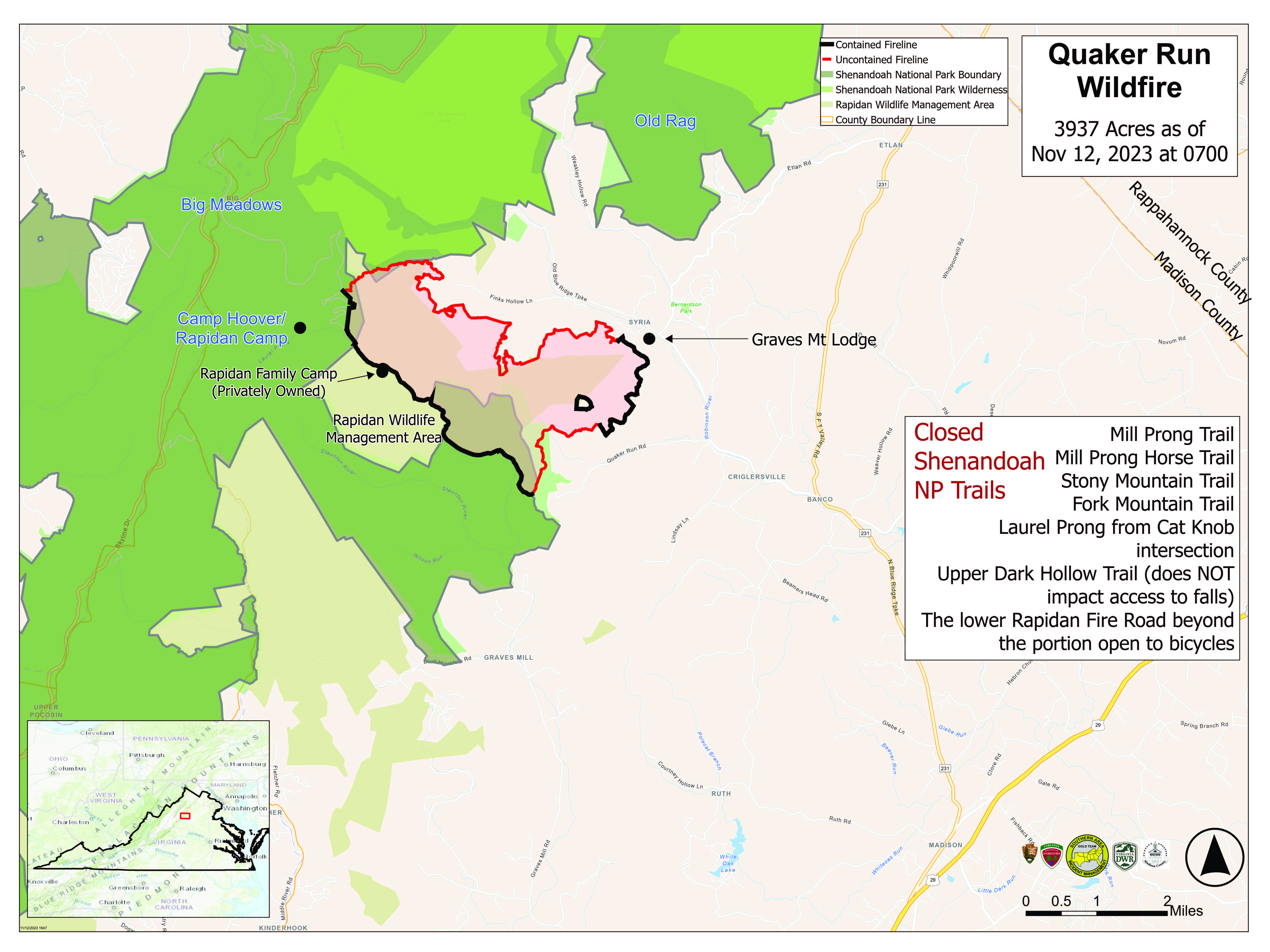
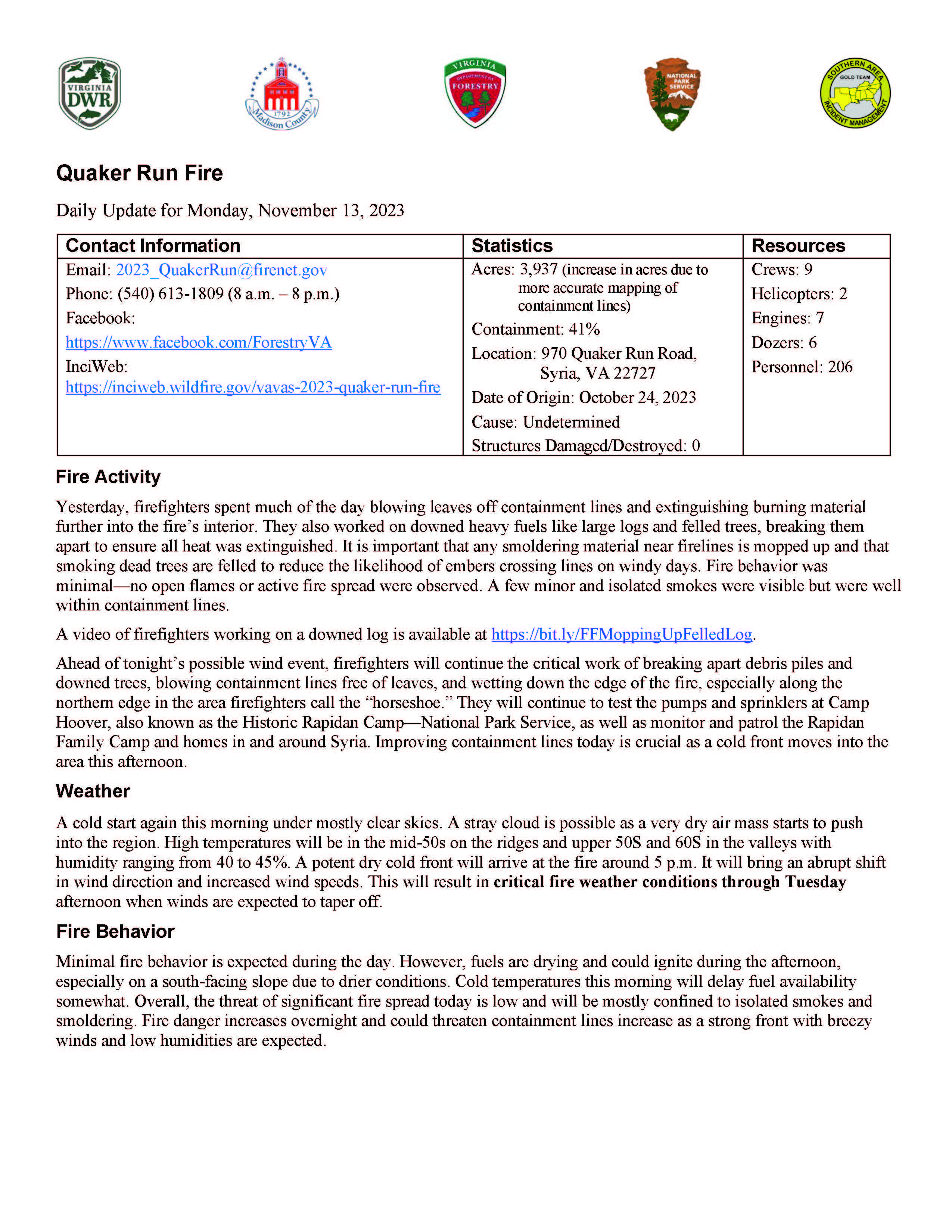
Quaker Run Fire Daily Update for Monday November 13 2023
Related Incident:
Publication Type: News
Contact Information
Statistics
- Acres: 3,937 (increase in acres due to more accurate mapping of containment lines)
- Containment: 41%
- Location: 970 Quaker Run Road, Syria, VA 22727
- Date of Origin: October 24, 2023
- Cause: Undetermined
- Structures Damaged/Destroyed: 0
- Crews: 9
- Helicopters: 2
- Engines: 7
- Dozers: 6
- Personnel: 206
Fire Activity
Yesterday, firefighters spent much of the day blowing leaves off containment lines and extinguishing burning material further into the fire’s interior. They also worked on downed heavy fuels like large logs and felled trees, breaking them apart to ensure all heat was extinguished. It is important that any smoldering material near firelines is mopped up and that smoking dead trees are felled to reduce the likelihood of embers crossing lines on windy days. Fire behavior was minimal—no open flames or active fire spread were observed. A few minor and isolated smokes were visible but were well within containment lines.
A video of firefighters working on a downed log is available at https://bit.ly/FFMoppingUpFelledLog.
Ahead of tonight’s possible wind event, firefighters will continue the critical work of breaking apart debris piles and downed trees, blowing containment lines free of leaves, and wetting down the edge of the fire, especially along the northern edge in the area firefighters call the “horseshoe.” They will continue to test the pumps and sprinklers at Camp Hoover, also known as the Historic Rapidan Camp—National Park Service, as well as monitor and patrol the Rapidan Family Camp and homes in and around Syria. Improving containment lines today is crucial as a cold front moves into the area this afternoon.
Weather
A cold start again this morning under mostly clear skies. A stray cloud is possible as a very dry air mass starts to push into the region. High temperatures will be in the mid-50s on the ridges and upper 50s and 60s in the valleys with humidity ranging from 40 to 45%. A potent dry cold front will arrive at the fire around 5 p.m. It will bring an abrupt shift in wind direction and increased wind speeds. This will result in critical fire weather conditions through Tuesday afternoon when winds are expected to taper off.
Fire Behavior
Minimal fire behavior is expected during the day. However, fuels are drying and could ignite during the afternoon, especially on a south-facing slope due to drier conditions. Cold temperatures this morning will delay fuel availability somewhat. Overall, the threat of significant fire spread today is low and will be mostly confined to isolated smokes and smoldering. Fire danger increases overnight and could threaten containment lines increase as a strong front with breezy winds and low humidities are expected.
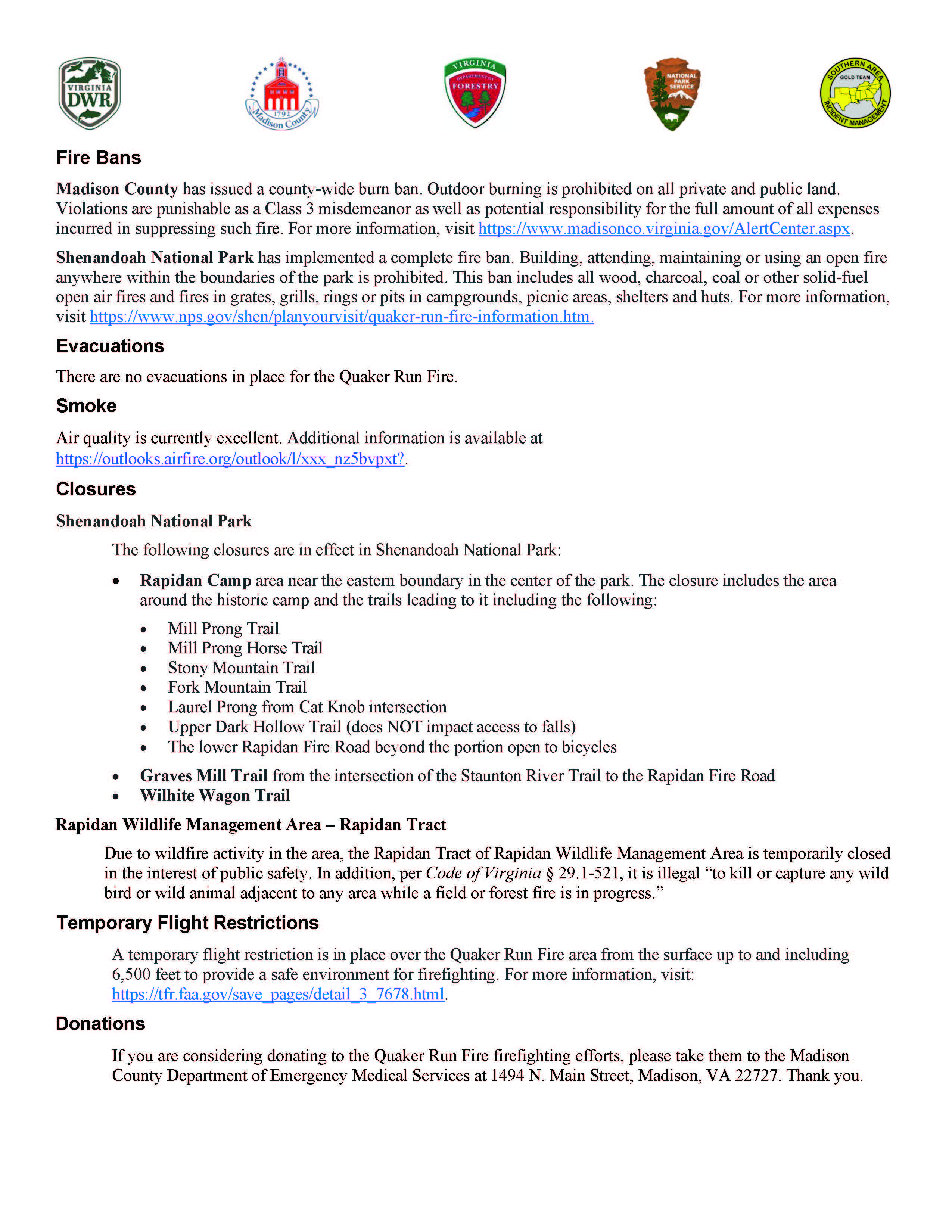
Fire Bans
- Madison County has issued a county-wide burn ban. Outdoor burning is prohibited on all private and public land. Violations are punishable as a Class 3 misdemeanor as well as potential responsibility for the full amount of all expenses incurred in suppressing such fire. For more information, visit https://www.madisonco.virginia.gov/AlertCenter.aspx.
- Shenandoah National Park has implemented a complete fire ban. Building, attending, maintaining or using an open fire anywhere within the boundaries of the park is prohibited. This ban includes all wood, charcoal, coal or other solid-fuel open air fires and fires in grates, grills, rings or pits in campgrounds, picnic areas, shelters and huts. For more information, visit https://www.nps.gov/shen/planyourvisit/quaker-run-fire-information.htm.
Evacuations
There are no evacuations in place for the Quaker Run Fire.
Smoke
Air quality is currently excellent. Additional information is available at https://outlooks.airfire.org/outlook/l/xxx_nz5bvpxt?.
Closures
Shenandoah National Park
The following closures are in effect in Shenandoah National Park:
- Rapidan Camp area near the eastern boundary in the center of the park. The closure includes the area around the historic camp and the trails leading to it including the following:
- Mill Prong Trail
- Mill Prong Horse Trail
- Stony Mountain Trail
- Fork Mountain Trail
- Laurel Prong from Cat Knob intersection
- Upper Dark Hollow Trail (does NOT impact access to falls)
- The lower Rapidan Fire Road beyond the portion open to bicycles
- Graves Mill Trail from the intersection of the Staunton River Trail to the Rapidan Fire Road
- Wilhite Wagon Trail
Rapidan Wildlife Management Area – Rapidan Tract
Due to wildfire activity in the area, the Rapidan Tract of Rapidan Wildlife Management Area is temporarily closed in the interest of public safety. In addition, per Code of Virginia § 29.1-521, it is illegal “to kill or capture any wild bird or wild animal adjacent to any area while a field or forest fire is in progress.”
Temporary Flight Restrictions
A temporary flight restriction is in place over the Quaker Run Fire area from the surface up to and including 6,500 feet to provide a safe environment for firefighting. For more information, visit: https://tfr.faa.gov/save_pages/detail_3_7678.html.
Donations
If you are considering donating to the Quaker Run Fire firefighting efforts, please take them to the Madison County Department of Emergency Medical Services at 1494 N. Main Street, Madison, VA 22727. Thank you.
Steep Valley Fire Closure Orders
Related Incident:
Publication Type: Closures
Closure order and map of closure order for the Steep Valley Fire which covers the War Ridge and Backus Mountain areas. Please see attached PDF for complete details of the closure area along with a map detailing the closure area. The closure will remain in effect until park managers and fire personnel determine the area is safe for the public to re-enter.
Crews Wrap up Test Fire Postpone Ignitions
Related Incident:
Publication Type: News
Fire crews returned to the unit this morning to continue strengthening containment lines and to monitor fire behavior from yesterday’s test fire. Weather conditions today supported additional growth of approximately 15 acres on the test fire. They found that fuel moisture throughout the unit, especially along its boundaries, are variable with some areas still holding moisture.
Based on that information, fire managers decided to postpone ignitions on the rest of the unit until conditions conducive for ignitions arrive. Crews will remain on scene to secure the test fire area before the majority of personnel are demobilized and released. Some fire crew members will continue to patrol and monitor the unit, as they have been since 4,000 acres were treated in mid-October.
Ignitions Completed for the Day
Related Incident:
Publication Type: News
Nov. 12, 2023—Fire crews treated 500 acres, completing blackline around the 4,500-acre unit.
Blackining is pre-burning fuels along the control line, in this case roads, before interior areas are treated. The blackline is usually up to 100 feet deep.
With blackline completed, ignitions can continue on the remainder of the unit’s interior on future days when weather and ventilation allow.
2,600 acres have been accomplished to date.
Test Firing to Continue Today
Related Incident:
Publication Type: News
Nov. 12, 2023—Fire crews are back on scene today for another test burn, this time for an estimated 10-15 acres (yesterday’s test burn was about three acres). If all goes well, crews will potentially move forward with ignitions Monday, most likely only treating a portion of the remaining 2,333 acres.
4,000 acres of the 6,333-acre unit were treated with prescribed fire in October. The remaining acres are located north of Forest Road 1950 between a half mile east of McCrystal Campground and Windy Gap.