
November 20 2023 Pile Burn Update
Related Incident: Lolo National Forest Prescribed Fire Operations
Publication Type: Announcement
Pending conditions, the Superior Ranger District will conduct pile burning today to reduce hazardous fuels from previous vegetation management operations.
Superior Ranger District: Firefighters will initiate up to 25 acres of pile burning operations on two different units located 8 miles southeast of Superior. Smoke may be visible from Superior and Interstate 90.
Pile burning is only implemented under the right conditions. Favorable conditions include correct temperature, wind, fuel moisture and ventilation for smoke. When these criteria are met, firefighters implement, monitor, and patrol each burn to ensure it meets forest health and public safety goals including air quality.
Crews Continue to Patrol and Monitor
Related Incident:
Publication Type: News
Despite recent rain and snowfall over the unit, fire crews will continue to patrol and monitor the prescribed fire until fire managers call it out.
Crews have been on site patrolling and monitoring the fire since Wednesday, Nov. 15, when the last update was published. Along with some clean-up ignitions the following day, the fire continued to creep and smolder, consuming surface fuels like fallen pine needles and oak leaves.
In total, fire managers’ goal of treating the entire 4,500-acre unit has been met.
Daily Update Sunday November 19 2023
Related Incident: 2023 Black Bear Fire
Publication Type: Announcement
INCIDENT STATISTICS:
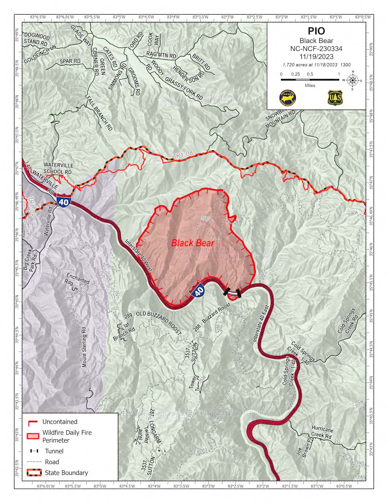
Current Size: 1,720 Acres
Current Containment: 0%
Start Date: November 16, 2023
Cause: Unknown
Total personnel: 193
HIGHLIGHTS: Weather conditions yesterday moderated fire behavior, giving crews the opportunity to work on primary and contingency dozer and handlines.
Along the Appalachian Trail, hand line was completed from the communications site east to Brown Gap and continues west towards I-40. On the eastern side of the fire, hand line has begun along the Groundhog Creek drainage from the Appalachian Trail to the north and I-40 to the south. A dozer completed contingency line work along Cold Spring Creek Road (Forest Roads 148 and 148A) from I-40 to Brown Gap at the Appalachian Trail.
Work on containment lines will continue today, taking advantage of the weather before anticipated winds tomorrow and rain Tuesday and Wednesday. An increase of fire activity is expected this afternoon as the sun dries fuels out – active fire will be visible along I-40 and smoke will remain in the area throughout the day.
WEATHER: High pressure will settle over the area today. After some morning valley fog, dry, sunny, seasonally cool weather is expected, with high temperatures of 55-65 degrees and minimum humidity of 35-45%. Winds are forecast to be light and variable, and smoke concentration may be higher today due to lack of air movement.
FIRE BEHAVIOR: Surface fuels were wetted by rain yesterday and will not likely support fire spread. Heavy fuel concentrations, such as log ends, snags, and stumps, will retain heat and may provide a source of ignition to adjacent fuels. Fire behavior characteristics for the day include smoldering and areas of limited creeping.
SMOKE: Calm winds will keep smoke in the area of the fire – expect low visibility when driving along I-40.
EVACUATIONS: None
CLOSURES AND DELAYS: For public and firefighter safety, a closure order is in effect over the fire area. The Appalachian Trail is closed from Interstate 40 to Browns Gap. You can find more information at linktr.ee/blackbearfire. Road closures are in effect for Cold Springs Road and Brown Gap Road. Impacts to travel along Interstate 40 are expected. Check current road conditions at drivenc.gov.
Matts Creek Fire Update Nov 19 2023
Related Incident:
Publication Type: News
Acres: 7,614
Containment: 15%
Start Date: Sunday, November 12, 2023
Cause: undetermined
Total personnel: 286
Location: James River Face Wilderness and Blue Ridge Parkway
Fuels: Mixed hardwoods, shrubby vegetation, and leaf litter
Please note: Firefighters will use a helicopter to ignite ridgetops in the northwestern portion of the fire this afternoon, east of Greenlee, between the James River and Belfast Creek. Firefighters will take advantage of today’s favorable weather conditions to produce a low-intensity fire which will remove vegetation and protect private communities as well as the forest. This strategy is in response to an anticipated easterly wind tomorrow which could cause the fire to move to the west. Firefighters hope to proactively engage the fire “on our terms.”
Operations
A new fire was detected near Snowden this morning that burned roughly half an acre. Crews quickly located the new start and will work to secure it today. Yesterday, firefighters directly engaged the main fire in the southeastern fire perimeter. By working closer to the active fire front, crews kept the fire away from a section of privately owned lands.
The fire was also active in the southwestern portion and burned laterally along the slope. Firefighters worked to build contingency lines (backup firelines) by using road systems to help control the forward progression of the fire. Fire Operations staff reported that there are still fire-weakened trees along the Blue Ridge Parkway that may pose a threat to public safety.
A drone was used for tactical firing operations along a ridgeline to check the fire’s progression. This is an area where step terrain and hazard trees make it dangerous for firefighters on the ground. Drones can perform precise firing operations, which produce less smoke.
Today, firefighters will continue to improve existing fire containment lines and patrol the Blue Ridge Parkway for burning material rolling into the roadway. Crews continue to improve and strengthen handline to the James River. Firefighters will continue to work with local fire departments to assess structures along Hunt Camp Road and along the western side of the fire. They will continue to work throughout the night to monitor and contain the fire.
People and equipment on the fire include 6 hand crews, 11 engines, 4 helicopters, 2 water tenders and 1 drone.
Weather and Fire Behavior
Today is expected to bring west/northwest winds of 5-10 miles-per-hour and temperatures in the upper 50s. The fire area will see poor relative humidity recovery of between 35-40 percent on the ridgetops and humidity will drop as the day progresses. Monday will bring mostly cloudy skies with moderate moisture of 60 percent. Northeast winds should be around 4-9 mph with temperatures in the low 50s. Fire activity is expected to increase due to drier conditions overnight. Active fire behavior is expected all day, particularly on the eastern flank. The fire continues to move to the southeast, particularly in areas where winds align with terrain.
Smoke and Air Quality
Heavy smoke is likely in communities and along roadways southeast of the fire today. An incident air resource advisor issues smoke reports at https://outlooks.wildlandfiresmoke.net/outlook For more information on air quality visit AirNow.gov. Please use caution when driving in low-visibility areas.
Temporary Flight Restrictions
A Temporary Flight Restriction is in place around the fire area. Further information can be found at https://tfr.faa.gov/save_pages/detail_3_4016.html
Road Closures
Petites Gap Road (FSR35) is closed to all public use between the Belfast Trailhead and the Blue Ridge Parkway. This closure may be extended to the intersection of Arnold Valley Road (SR 781) and Black Run Road due to fire activity.
Blue Ridge Parkway Temporary Closure
The Blue Ridge Parkway is closed from milepost 66.3, near US Highway 501, to milepost 85.9, at VA Route 43 until further notice. Park visitors should plan for a detour from the north or south using adjacent routes and Interstate 81.
Closures
The James River Face Wilderness and all associated trails, including a section of Appalachian National Scenic Trail, are closed to all public use due to the on-going wildland fire.
The following areas are temporarily closed to allow for public and fire fighter safety:
- Locher Tract
- Glenwood Horse Trail (FT#3004) from the Blue Ridge Parkway to the Hellgate Trailhead
- Appalachian Trail (FT #1) from James River Foot Bridge to Petites Gap Road (FR #35)
- James River Foot Bridge Parking Lot
- Matts Creek Trail (FT #4/Old A.T.)
- Piney Ridge Trail (FT #2)
- Gunther Ridge Trail (FT #8)
- Belfast Trail (FT #9)
- Sulphur Springs Trail (FT# 3001)
Use caution and obey all road signs for your safety. Motorists should be alert for firefighter vehicles and smoke.
Fire Restrictions
Stage 1 Fire Restrictions in effect: For the protection of public health and safety, the following acts are prohibited on all lands administered by George Washington & Jefferson National Forest.
1. Building, maintaining, attending, or using a fire or campfire outside of developed recreation sites.
2. Possessing, discharging, or using any kind of firework or other pyrotechnic device.
Campfires in a Forest Service provided metal fire pit, ring or grill at a developed recreation site are allowed.
Black Bear Fire Forest Order Emergency Closure November 19 2023
Related Incident: 2023 Black Bear Fire
Publication Type: Closures
UNITED STATES DEPARTMENT OF AGRICULTURE
UNITED STATES FOREST SERVICE
PISGAH & CHEROKEE NATIONAL FORESTS
APPALACHIAN & UNAKA RANGER DISTRICTS
ORDER NO. 08-11-04-24-001
FOREST ORDER
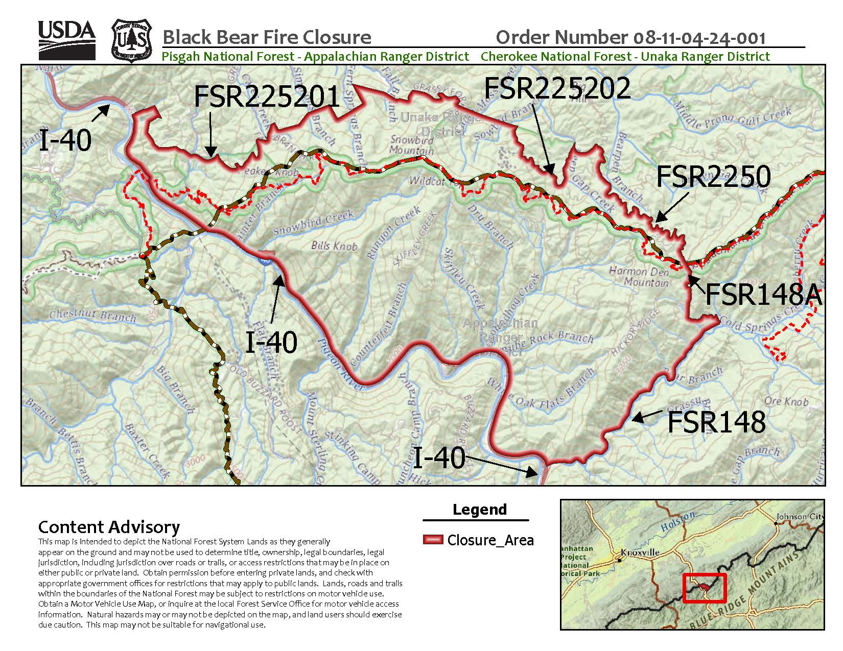
Pursuant to the provisions of 16 USC § Section 551, and Title 36 CFR §Section 261.50 (a) and 261.50(b), the area of National Forest System lands in the “Black Bear Fire Area” located on the Appalachian Ranger District of the Pisgah National Forest and Unaka Ranger District of the Cherokee National Forest is closed to entry. The area is closed to entering or being present in the area, including on roads or trails, so to mitigate risks to public health and safety, to provide for disaster and safety operations, and to protect the resources while responding to and recovering from the Black Bear Fire. This Order is effective through December 31, 2023, or until rescinded by an authorized Forest Service official, whichever occurs first.
The area is signed closed from entering or being present is further indicated on the attached map. Only National Forest System lands are impacted by this closure. On the Appalachian Ranger District, the Appalachian Trail is closed from 1-40 to Brown Gap including Groundhog Creek shelter. The closure area can be described by the following perimeter:
- West of Cold Springs Creek Road (FSR148) and Browns Gap Road (FSR148A),
- South of the Appalachian Trail, and
- North of I-40 to the North Carolina State Line
On the Unaka Ranger District, the Appalachian Trail is closed from 1-40 to Brown Gap.
The closure area can be described by the following perimeter:
- North of the Appalachian Trail
- North of I-40 to Carmichael Tract Road (FSR225201)
- South of Carmichael Tract Road (FSR225201) to the Tennessee State Line
- South of Snowbird Road (FSR225202) to the Tennessee State Line, and
- South of Brown Gap Road (FSR2250) to the Tennessee State Line
All roads and trails on the closure perimeter and within the closure area are closed:
- Cold Springs Creek Road (FSR148)
- Browns Gap Road (FSR148A)
- Harmon Den Mountain Road (FSR352)
- Groundhog Road (FSR3522)
- Hickory Ridge Road (FSR357)
- Skiffley Creek Road (FSR3580)
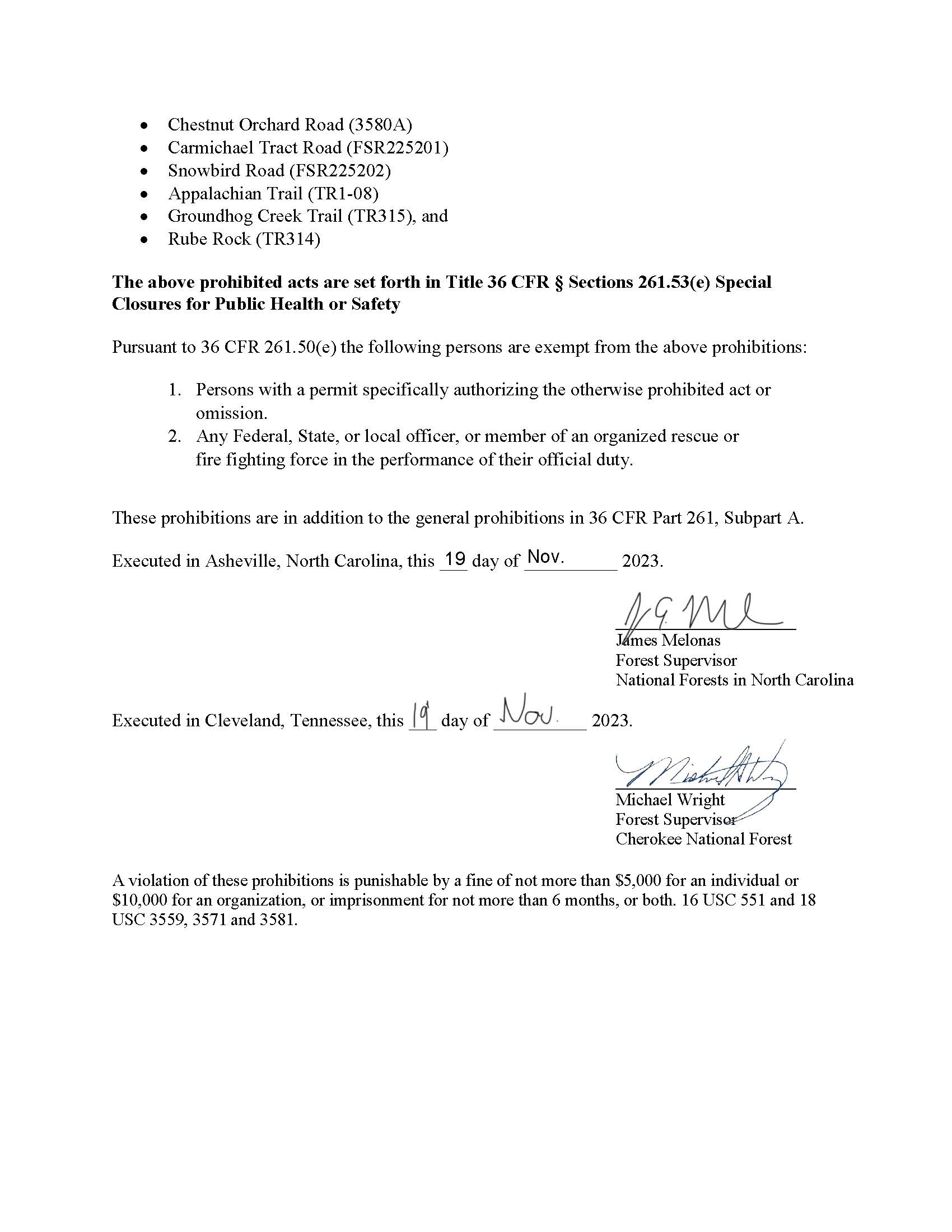
- Chestnut Orchard Road (3580A)
- Carmichael Tract Road (FSR225201)
- Snowbird Road (FSR225202)
- Appalachian Trail (TR1-08)
- Groundhog Creek Trail (TR315), and
- Rube Rock (TR314)
The above prohibited acts are set forth in Title 36 CFR § Sections 261.53(e) Special Closures for Public Health or Safety
Pursuant to 36 CFR 261.50(e) the following persons are exempt from the above prohibitions:
- Persons with a permit specifically authorizing the otherwise prohibited act or omission.
- Any Federal, State, or local officer, or member of an organized rescue or fire fighting force in the performance of their official duty.
These prohibitions are in addition to the general prohibitions in 36 CFR Part 261, Subpart A.
A violation of these prohibitions is punishable by a fine of not more than $5,000 for an individual or $10,000 for an organization, or imprisonment for not more than 6 months, or both. 16 USC 551 and 18 USC 3559, 3571 and 3581.
Matts Creek Fire Smoke Outlook Nov 19
Related Incident:
Publication Type: News
Fire
Matt's Creek fire continues to move around in the heavy leaf litter and shrubs within the Thunder Ridge NF Wilderness Area southeast of the Natural Bridge. Yesterday's winds pushed active fire edges on the west flank of the fire, resulting in additional fire spread between Belfast and Big Hellgate Creek towards the James River. Light west winds today will slow fire activity and reduce smoke production into the evening. Warm and dry conditions will continue to support fast fire growth in the continuous leaf litter. Visit Inciweb for closures, contacts, and more information.
Smoke
Today-expect USG-VERY UNHEALTHY conditions between Bedford and Lexington. Light west winds will disperse smoke along I-81 and the Blue Ridge Parkways. Today's clear skies, light winds, and warmer temps will produce short periods of reduced roadway visibility and pockets of heavier smoke concentrations along drainage and valley bottoms. This evening, smoke will continue to settle in communities between the Natural Bridge, Buena Vista, Amherst, and Lynchburg. A cooler, moist air mass is moving into the area Monday night bringing improved air quality.
Matts Creek Fire Media Briefing Location
Related Incident:
Publication Type: Announcement
The media briefing location for the Matts Creek Fire will be located at the James River Foot Bridge, Appalachian National Scenic Trail, Big Island, VA 24526. The media briefing will begin at noon.
Matts Creek Fire Closures and Restrictions
Related Incident:
Publication Type: Closures
As of Nov. 18, the following closures and restriction remain in place for the Matts Creek Fire area:
Closures and Restrictions: The entire James River Face Wilderness is closed to all public use.
Road Closures: Petites Gap Road (FSR35) is closed to all public use between the Belfast Trailhead and the Blue Ridge Parkway. Arnold Valley Road (SR 781) is closed for firefighter and public safety.
Blue Ridge Parkway Temporary Closure: The Blue Ridge Parkway is closed from milepost 66.3, near US Highway 501, to milepost 85.9, at VA Route 43 until further notice. Park visitors should plan for a detour from the north or south using adjacent routes and Interstate 81.
Closures: The James River Face Wilderness and all associated trails, including a section of Appalachian National Scenic Trail, are closed to all public use due to the on-going wildland fire.
The following areas are temporarily closed to allow for public and fire fighter safety:
- Locher Tract
- Glenwood Horse Trail (FT#3004) from the Blue Ridge Parkway to the Hellgate Trailhead
- Appalachian Trail (FT #1) from James River Foot Bridge to Petites Gap Road (FR #35)
- James River Foot Bridge Parking Lot
- Matts Creek Trail (FT #4/Old A.T.)
- Piney Ridge Trail (FT #2)
- Balcony Falls Trail (FT #7)
- Gunther Ridge Trail (FT #8)
- Belfast Trail (FT #9)
- Sulphur Springs Trail (FT# 3001)
Use caution and obey all road signs for your safety. Motorists should be alert for firefighter vehicles and smoke.
Trail Springs and Mill Creek 2 Fire Update November 18 2023
Related Incident: Trail Springs FireMill Creek 2 Fire
Publication Type: News
Trail Springs and Mill Creek 2 Fires
Update: November 18, 2023
Type 4, Incident Commander Levi Sensenig, 20 Personnel
This will be the final regularly distributed Update for the Trail Springs and Mill Creek 2 Fires. The San Juan National Forest Facebook page and the Inciweb pages for both fires will continue to provide updates on any significant developments, as warranted.
Trail Springs Fire | Size: 1358 Acres | Containment: 43% | Cause: Lightning
The fire is located 12 miles northwest of Pagosa Springs, on Forest land east of West Devil Creek. Higher humidity and some light rainfall on Thursday have helped reduce fire activity and smoke output. More precipitation is expected on Saturday and Sunday. The fire is mostly burning through grasses, brush and dead and down fuels, and fire activity is within the defined management area of the fire. Firefighters have established containment line to protect values to the east. Crews have also been repairing ground where fireline had been established, but is no longer needed. The San Juan Type 4 team will continue to patrol the fire area and firefighters are also prepared to respond to any new fires within the Pagosa Ranger District.
Mill Creek 2 Fire |
Size: 150 Acres | Containment: 0% | Cause: Human
The fire is located in steep, rugged, terrain near the border of the South San Juan Wilderness Area, northeast of Pagosa Springs. Precipitation this week helped reduced smoke output, and rain and snow are possible over the weekend. The fire has been slowly creeping through isolated pockets of dead and down wood on the mountain. No homes, ranches or other significant values are at risk. Firefighters will continue to closely watch fire activity.
Weather:
Two systems move through over the weekend, bringing potential rain and thundershowers Saturday afternoon, and then on Sunday, rain turning to snow. High temps Saturday around 40, with SW winds that could become gusty and erratic near Thunderstorms. Colder on Sunday with rain turning to snow and gusty winds out of the SW.
San Juan NF Temporary Closures: An area closure is in place involving roads and trails in or near the Trail Springs Fire area (Middle Mountain area). Details of the closure are in the Closures section of this Inciweb site, and on the “Alerts and Notices” page of the Forest website: https://www.fs.usda.gov/alerts/sanjuan/alerts-notices
Fire Information: 970-426-5370 (8 a.m. to 4:30 p.m.) | Facebook: https://www.facebook.com/sanjuannationalforest
Daily Update Saturday November 18 2023
Related Incident: 2023 Black Bear Fire
Publication Type: Announcement
1,193 acres | 0% containment | 166 personnel assigned
Highlights: Primary containment lines have been identified around the Black Bear Fire, utilizing Interstate 40 on the southwest, the Appalachian Trail from I-40 to Groundhog Creek Shelter along the north, and Forest Road 3580 on the east south to I-40. Groundhog Creek drainage is being scouted as a better eastern containment line to further limit fire spread potential. Containment line work along the Appalachian Trail will consist of raking away forest floor litter and removing fallen trees, much like normal trail maintenance, to minimize impacts along the National Scenic Trail.
Last night’s wet weather is giving firefighters an excellent opportunity to put containment lines in place, as well as for fire managers to work with local county, state, and federal agencies to plan for drier conditions conducive to fire spread beginning this weekend through early next week before additional rainfall occurs later in the week.
Resources assigned to the fire include four 20-person hand crews, 1 Engine, and 1 dozer. Aerial resources include three helicopters.
Facebook: https://www.facebook.com/nfsnc/
Weather: A cold front passed through the region last night, bringing showers and gusty northwest winds. For today, lingering clouds and showers can be expected this morning with gradual clearing in the afternoon. Ridges may be obscured by cloud cover this morning. It will remain breezy with northwest winds of 15-25 mph. The wind is expected to diminish tonight as skies clear. It will be much cooler today and tonight with highs of 48-55 and lows in the 30’s.
Fire Behavior: Unless fire fuels were wetted by rain, surface fuels will support very active fire spread with slope and wind. Heavy fuel concentrations will cause flare-ups and accelerated spread rates. Fire behavior characteristics for the day include wind and slope aligned head fire spread including fingering runs on steep slopes. Expect active flanking fire with potential head runs. Sustained backing may produce slope reversals in creek bottoms.
Air Quality: Expect smoke when driving along I-40 near the fire. Air quality information provided by the North Carolina Department of Environmental Quality is available at airquality.climate.ncsu.edu/.
Burn Bans: Due to increased fire risk, the N.C. Forest Service has issued a ban on all open burning until further notice in several counties in western North Carolina. For more information visit https://www.ncforestservice.gov/fire_control/sit_report.htm.
The U.S. Forest Service has implemented fire restrictions across the Pisgah and Nantahala National Forests. To view the closure order visit www.fs.usda.gov/alerts/nfsnc/alerts-notices.
Temporary Flight Restriction (TFR): There is a flight restriction over the fire area and drones are also prohibited. If you fly, we can't!
Evacuations: None at this time.
Closures: For public and firefighter safety, the Appalachian Trai is closed from Interstate 40 to Max Patch. Road closures are in effect for Cold Springs Road and Brown Gap Road. Impacts to travel along Interstate 40 are expected. Check current road conditions at drivenc.gov.