
Daily Update Transition to type 3 team as fire winds down 06 08 2024
Related Incident: Blue 2 Fire
Publication Type: News
Transition to type 3 team as fire winds down
Daily Update: June 8, 2024
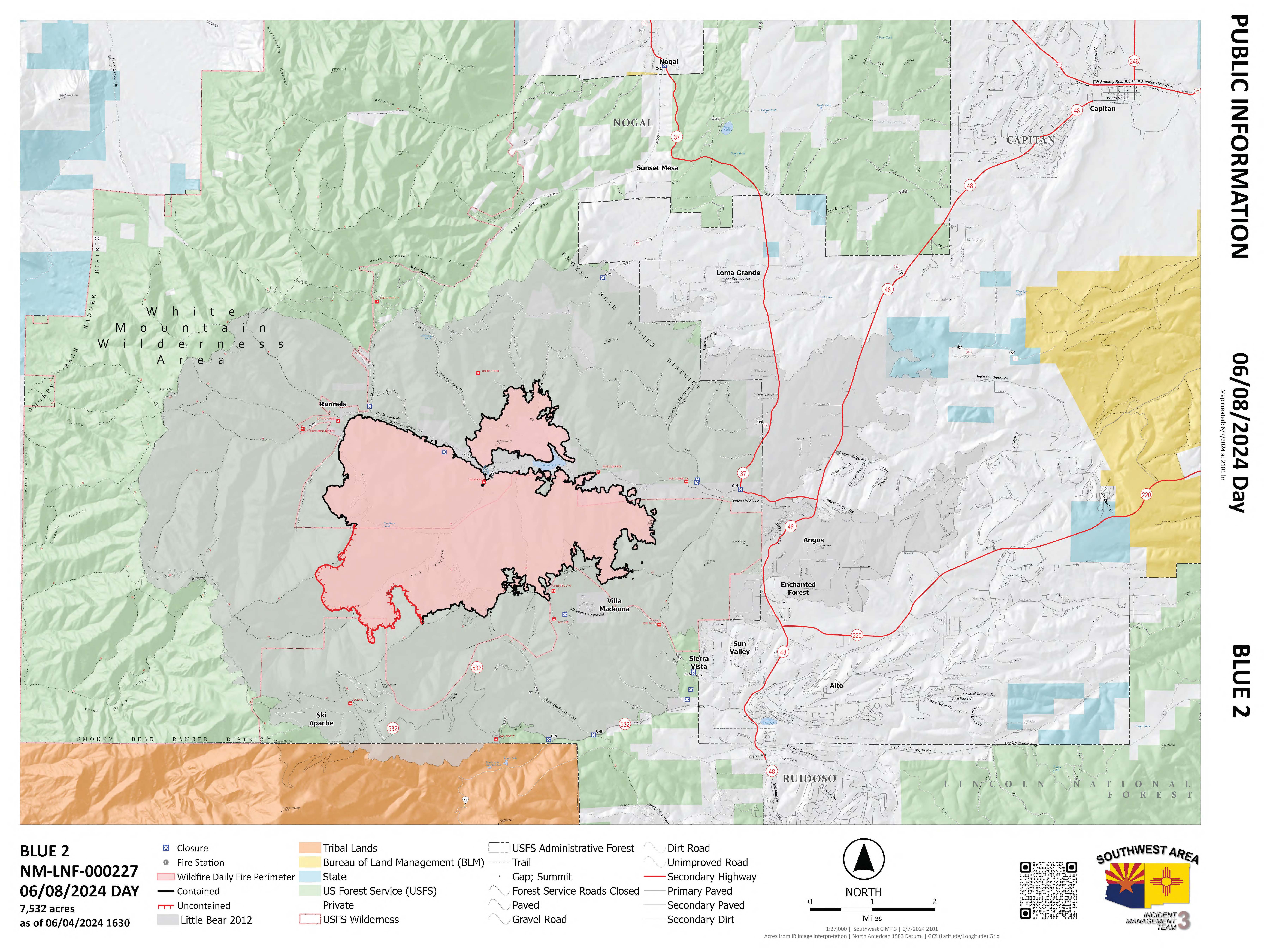
Acres: 7,532 Start '
Date: May 16, 2024
Location: 8 miles North of Ruidoso, White Mountain Wilderness Area
Cause: Lightning
Personnel: 235
Fuels: Timber/Grass/Brush
Containment: 87%
Resources: 2 crews | 11 engines | 2 helicopters | 2 bulldozers | 1 water tender | 3 masticators
Highlights: Today at 6 pm the fire will transfer command to the Pecos Zone type 3 team with Josh DuBoise as the new incident commander. Fire suppression repair is nearly complete across the fire area. Resource advisors inspect work as it is completed to ensure it meets the standards set by the Forest Service and New Mexico Forestry Division.
Operations: Dozer line north of the fire between the 108 road and 131 road has been repaired. The handline west of Enchanted Forest is also repaired. Repair started on the containment line north of Eagle Creek Summer Homes. Masticators continue to finish the contingency line along the Forest boundary, west of Loma Grande. Excavators and crews are piling brush around the mastication line. Crews continue to backhaul the remaining equipment and patrol containment lines. The uncontained section of the fire, north of Buck Mountain, is patrolled by uncrewed aerial systems (drones) as well as monitored by firefighters on foot. Law enforcement continues to enforce the forest closure so firefighters can safely complete their work. The team does have resources on standby for any initial attack due to potential lightning and wind hazards.
Weather: No rain fell over the fire yesterday however a higher moisture pattern has set up in the region. Storms may bring dry lightning, gusty and erratic winds, and even small hail.
Smoke: The fire is producing minimal smoke. Surrounding communities will see good air. Transported smoke or other particulate matter may create hazy skies on occasion. The interactive smoke map can still be found at fire.airnow.gov/
Closures: In the interest of public safety, camping and other recreation activities in the Bonito Lake Area are still restricted due to ongoing firefighter activities. The Forest closure order will continue to remain in effect for the White Mountain Wilderness Area.
Evacuations: All evacuation statuses have been lifted. For an interactive evacuation map go to tinyurl.com/Blue2Evacs
Safety: A Temporary Flight Restriction (TFR) is in place over the area, which includes uncrewed aircraft systems or drones. Find the TFR at tfr.faa.gov/tfr_map_ims/html/

BURNED AREA EMERGENCY RESPOSE TEAM ASSESSING FIRE SEVERITY ON THE BLUE 2 FIRE 06 07 2024
Related Incident: Blue 2 Fire Post-Fire BAER
Publication Type: News
BURNED AREA EMERGENCY RESPOSE TEAM ASSESSING FIRE SEVERITY ON THE BLUE 2 FIRE
Ruidoso, NM., June 7, 2024 — A Burned Area Emergency Response (BAER) team, led by Terry Hardy and Edgar Martinez, began making burned area surveys of the Blue 2 Fire yesterday. BAER team assessments are rapid evaluations of post-fire conditions of the burned landscape to determine the level of risk from potential flooding and debris flow to values on National Forest System lands. If unacceptable risks are found the team recommends appropriate and effective emergency stabilization measures to reduce the risks to National Forest lands and values. BAER emergency stabilization efforts are focused on the protection of human life and safety, property, and critical cultural and natural resources.
BAER teams typically consist of scientists and specialists including hydrologists, geologists, soil scientists, road engineers, botanists, wildlife and fisheries biologists, archaeologists, recreation and trails specialists, and geographic information specialists, from federal and state agencies. BAER teams conduct field surveys and use science-based models to rapidly evaluate and assess the burned area.
BAER teams analyze the data they collect during field surveys to produce a “Soil Burn Severity” map. This is the first step in assessing potential watershed impacts from wildfires to values that may be at-risk from potential increased flooding, sedimentation, debris flows and rockfall. BAER teams produce a report that includes a description of the assessment and findings for the burned area’s post-fire conditions along with recommended emergency stabilization measures and actions. Another key role of BAER Teams is the sharing of data and products with local cooperating agencies that may be affected by post fire flood events. For more information, please see the attached link for the Blue 2 Fire BAER inciweb site at Nmlnf Blue 2 Fire Postfire Baer Information | InciWeb (wildfire.gov)
Daily Update 06 07 2024
Related Incident: Indios Wildfire
Publication Type: News
Resources shift as repair activities continue
Daily Update – Friday, June 7, 2024
Acres: 11,500
Start Date: May 19, 2024
Location: 7 miles north of the village of Coyote, NM
Personnel: 415
Completion: 86%
Fuels: Timber
Highlights: Completion remains at 86% today as crews continue repair and mop-up activities around the fire perimeter. Suppression repair activities are focused on the northwestern fire area where the majority of firefighting actions were implemented. As firefighters complete suppression repair along the western flank, crews are being redistributed to other areas to support ongoing chipping operations.
Operations: As the fire activity diminishes, crews continue to patrol and monitor the fire perimeter to search for any remaining hot spots. Firefighters continued repair activities on the western side where the fire temporarily crossed the line last week before crews successfully stopped the spread. Yesterday, smoke was visible on the western side of the fire perimeter. Crews were sent to the area to investigate on the ground while an uncrewed aircraft system, also known as a drone, assisted the search by air. Firefighters determined that the source of the smoke was an interior pocket of unburned green vegetation inside the fire control lines. Due to its location, firefighters determined that the smoldering fire posed no threat to the control lines. Further south along the western flank, chipping and grading activities were completed on Forest Roads 64 and 77 near Corrales Ranch. These crews then shifted to address repair and chipping needs on Forest Roads 64A and 467. A large chipping operation is ongoing along these roads to ensure that all cut brush is removed or reduced to small wood chips to minimize the likelihood of future ignition. Firefighters who completed structure assessments for residents south of the fire have now been reassigned to respond to any potential new fire starts near the Indios Fire. Crews from the eastern side of the fire will be redistributed to other areas to assist in suppression repair, including backhauling equipment and installing water bars along handlines to minimize erosion.
Weather: Mid-level cloud cover will move into the area today; however, temperatures remain high and humidity values remain low. Scattered thunderstorms may form to the east with a chance for outflow winds and rain over the fire. Much better chances for showers and thunderstorms are expected on Sunday and Monday with possible wetting rains. Strong gusty winds are possible near any storms.
Smoke: Minimal smoke impacts are expected for the foreseeable future. Light dispersed visible smoke will diminish over the next few days. Smoke sensors have been installed and will remain in the communities of Coyote, Gallina, Cañones, and at the Monastery of Christ in the Desert. View an interactive smoke map at https://fire.airnow.gov/. Learn more about smoke impacts at https://www.env.nm.gov/air-quality/fire-smoke-links/.
Closures: The Santa Fe National Forest has issued an emergency area closure for the Indios Fire. The full closure order (No. 03-12-05-23-22) and map are available on Inciweb. Camping and water will be available at the Coyote Ranger Station for Continental Divide Trail hikers impacted by this closure.
Safety: A temporary flight restriction (TFR) is in place over the area, which includes uncrewed aircraft systems or drones. More information on the dangers drones pose to wildland firefighting aircraft and personnel on the ground can be found at: https://uas.nifc.gov/.
inciweb.wildfire.gov/incident-information/nmsnf-indios-wildfire / nmfireinfo.com
575-323-2290 / x.com/SantafeNF / facebook.com/santafeNF / 2024.indios@firenet.gov
Actualización del día: Reparación del obra de supresión está a punto de concluir 06 07 2024
Related Incident: Blue 2 Fire
Publication Type: News
Reparación del obra de supresión está a punto de concluir
Actualización del día: 7 de junio de 2024
Acres: 7,532 Fecha de inicio: 16 de Mayo de 2024
Ubicación: White Mountain Wilderness aproximadamente a 8 millas al norte de Ruidoso
Personal total: 273 Causa: Rayo
Combustibles: Arboles/ Hierba/Arbustos Contención: 87%
Recursos: 4 equipos | 12 motores | 2 helicópteros | 2 bulldozers | 1 licitaciones de agua | 3 masticadores
Puntos destacados: La reparación de la supresión de incendios está casi terminada en toda la zona del incendio. Los consejeros de recursos inspeccionan los trabajos a medida que se completan para garantizar que cumplen las normas establecidas por el Servicio Forestal y la División Forestal de Nuevo México.
Operaciones: La línea del topadora al norte del incendio entre la carretera 108 y la 131 ha sido reparada. También se ha reparado la línea de contención al oeste de Enchanted Forest. Se ha empezado a reparar la línea de contención al norte de Eagle Creek Summer Homes. Los masticadoras o máquinas que trituran continúan terminando el trabajo de trituración de los restos y ramas caídas en la línea de contingencia a lo largo del límite del Bosque, al oeste de Loma Grande. Las cuadrillas continúan retrocediendo el equipo restante y patrullando las líneas de contención. La sección no contenida del incendio, al norte de Buck Mountain, es patrullada por sistemas aéreos no tripulados (drones), así como vigilada por bomberos a pie. A medida que los bomberos terminan su trabajo, abandonan el incidente para regresar a casa o dirigirse a otros incendios. Las fuerzas del orden siguen haciendo cumplir el cierre del bosque para que los bomberos puedan terminar su trabajo con seguridad.
El tiempo: Las temperaturas han ido subiendo hasta situarse muy por encima de lo normal, pero en la región se ha establecido un patrón de aumento de la humedad. Hoy entrará más humedad en la zona del incendio y aumentará durante el fin de semana. Las tormentas pueden traer rayos secos, vientos racheados y erráticos, e incluso granizo pequeño.
Humo: El fuego está produciendo humo mínimo. Las comunidades circundantes verán buen aire. Humo u otras partículas pueden crear cielos brumosos en ocasiones. El mapa interactivo del humo puede seguir consultándose en fire.airnow.gov/
Cierres: En interés de la seguridad pública, la acampada y otras actividades recreativas en la zona del lago Bonito siguen restringidas debido a las actividades de los bomberos. La orden de cierre del bosque seguirá en vigor para el área silvestre de White Mountain.
Evacuaciones: Se han levantado todos los estados de evacuación. Para ver un mapa de evacuación interactivo, visite tinyurl.com/Blue2Evacs
Seguridad: Sobre la zona hay una Restricción Temporal de Vuelo (TFR), que incluye los sistemas de aeronaves sin tripulación o drones. Encuentre el TFR en tfr.faa.gov/tfr_map_ims/html/
Teléfono: 575-386-5077(7 a -7 p) Inciweb: tinyurl.com/Blue2Fire
Correo electrónico: 2024.blue2@firenet.gov
Para más información, consulte el código QR o https://linktr.ee/bluefire.2024


Daily Update: Suppression repair nears completion June 7, 2024 06 07 2024
Related Incident: Blue 2 Fire
Publication Type: News
Suppression repair nears completion
Daily Update: June 7, 2024
Acres: 7,532 Start
Date: May 16, 2024
Location: 8 miles North of Ruidoso, White Mountain Wilderness Area Cause: Lightning
Personnel: 273
Fuels: Timber/Grass/Brush
Containment: 87%
Resources: 4 crews | 12 engines | 2 helicopters | 2 bulldozers | 1 water tender | 3 masticators
Highlights: Fire suppression repair is nearly complete across the fire area. Resource advisors inspect work as it is completed to ensure it meets the standards set by the Forest Service and New Mexico Forestry Division.
Operations: The dozer line north of the fire between the 108 road and 131 road has been repaired. The handline west of Enchanted Forest is also repaired. Repair started on the containment line north of Eagle Creek Summer Homes. The masticators continue to finish the contingency line along the Forest boundary, west of Loma Grande. Crews continue to backhaul the remaining equipment and patrol containment lines. The uncontained section of the fire, north of Buck Mountain, is patrolled by uncrewed aerial systems (drones) as well as monitored by firefighters on foot. As firefighters finish their work, they leave the incident to return home or head to other fires. Law enforcement continues to enforce the forest closure so firefighters can safely complete their work.
Weather: Temperatures have been climbing to well above normal, but an increased moisture pattern has set up in the region. More significant moisture will move into the fire area today and increase through the weekend. Storms may bring dry lightning, gusty and erratic winds, and even small hail.
Smoke: The fire is producing minimal smoke. Surrounding communities will see good air. Transported smoke or other particulate matter may create hazy skies on occasion. The interactive smoke map can still be found at fire.airnow.gov/
Closures: In the interest of public safety, camping and other recreation activities in the Bonito Lake Area are still restricted due to ongoing firefighter activities. The Forest closure order will continue to remain in effect for the White Mountain Wilderness Area.
Evacuations: All evacuation statuses have been lifted. For an interactive evacuation map go to tinyurl.com/Blue2Evacs
Safety: A Temporary Flight Restriction (TFR) is in place over the area, which includes uncrewed aircraft systems or drones. Find the TFR at tfr.faa.gov/tfr_map_ims/html/
Firefighters increase containment on Adams Fire; fire restrictions in effect 06 07 2024
Related Incident: Adams Fire
Publication Type: News
Highlights: The National Fire Prevention Education Team will be at rest stops around the Phoenix metro area this weekend. Stop by to learn how to secure trailer chains, check vehicle brakes, and maintain proper tire pressure. See the full list of locations here. Stage 1 Fire Restrictions are in effect for the Tonto, Coconino, and Apache-Sitgreaves National Forest, as well as other jurisdictions. Fire Restrictions Map for Arizona and New Mexico: https://wildlandfire.az.gov/fire-restrictions
Operations: Yesterday, fire crews made progress on containment on the north and south sides of the fire. Crews also repaired fences and trails that were used for accessing the fire during initial attack. Firefighters will continue strengthening and mopping up control lines around the west side through the week and into the weekend. Fire crews working on the Adams Fire are prepared to support the Tonto National Forest with any new wildfire starts if necessary.
Weather: The fire area will continue to be in an extreme heat warning, with highs of 108 degrees and humidity in the single digits. Fuel moisture is critically low, and fuels are very receptive to fire. Winds will be light out of the east, with gusts to 20 mph in the afternoon. This weather trend continues through the weekend, which will increase fire danger and the possibility of new wildfires.
Closures: Closure orders are in effect in the Tonto National Forest surrounding the Adams Fire. View the current closure order and Stage 1 fire restrictions here: https://www.fs.usda.gov/alerts/tonto/alerts-notices/?aid=87846
Safety: The health and safety of firefighters and the public are always the highest priority. Please avoid the area while crews conduct fire suppression operations. Citizens are urged to sign up for the Maricopa County Emergency Notification System. The system allows you to be quickly notified of emergency evacuations. To learn more about the Arizona Emergency Information Network visit: https://ein.az.gov/ready-set-go. Firefighting aircraft and drones are a dangerous combination. Drones in the area could lead to accidents or slow down wildfire suppression operations. If you fly…we can’t.
Smoke: Smoke from the Adams Fire has decreased; however, it may be visible in the surrounding areas for many days. Smoke will drift to the north and east due to prevailing winds. Individuals who are sensitive to smoke or have conditions aggravated by smoke are encouraged to take precautionary measures. An interactive smoke map at https://fire.airnow.gov/ allows you to zoom into your area to see the latest smoke conditions.
Location: 1 mile east of Fort McDowell, AZ
Start Date: June 2, 2024
Size: Approximately 5,029 acres
Percent Contained: 86%
Cause: Human
Vegetation: The fire is smoldering grass and brush.
Resources: 2 Type-1 Handcrews, 1 Type-2 Handcrew, 4 Helicopters, 12 Engines, and 2 Water Tenders.
Number of Personnel Assigned: 186
View wildfire statistics at Tonto National Forest’s fire dashboard.
Tonto National Forest: https://www.fs.usda.gov/main/tonto/fire
InciWeb: Adams Fire Fire email: 2024.adams@firenet.gov Information Phone: 928-275-8205
Social Media: Instagram @tontonationalforest, X @TontoForest and Facebook @TontoNationalForest
Prescribed Fire on State Line Planned 06 06 2024
Related Incident:
Publication Type: News
LA JARA, CO, June 3, 2024 – With favorable conditions in the forecast, Rio Grande National Forest fire crews have begun preparing for the 1,000-acre Bighorn/Stateline prescribed fire project located approximately six miles southwest of Mogote, CO. Ignitions could begin as early as Tuesday, June 11.
Two of the burn units are on the Conejos Peak Ranger District in Colorado and one 192-acre unit is on the Carson National Forest in New Mexico.
“There is a need to reduce fuel loading and prepare a seed bed that will be receptive to new growth,” said Judi Perez, acting Conejos Peak district ranger. “After a couple of years of unfavorable burn windows, we are excited to resume prescribed fire operations and to be working again with our Carson National Forest partners across the state line.”
The project aims to reduce downed slash from previous hand thinning treatments that were designed to improve forest health with secondary benefits of improving big game habitat and reducing fuel loading. The prescribed fire will reduce the overall fuel load, cycle nutrients, and stimulate the growth of grass, forbs and aspen.
Due to the location of the planned fire, smoke will be visible from around the southern San Luis Valley and parts of the Tres Piedras Ranger District and may be heavier locally. No significant smoke impacts to towns or highways are expected.
The Bighorn/Stateline project is part of the 3.8 million-acre Rio Chama Collaborative Forest Landscape Restoration Project, which supports the national Wildfire Crisis Strategy.
Updates for the Bighorn/Stateline will be posted on InciWeb at: https://inciweb.wildfire.gov/incident-information/corgf-bighorn-stateline-prescribed-fire
Burning will be announced on the Rio Grande National Forest’s Facebook and X social media platforms.
###
USDA is an equal opportunity provider, employer and lender.
THREE PHASES OF WILDFIRE RECOVERY 06 06 2024
Related Incident: Blue 2 Fire Post-Fire BAER
Publication Type: Announcement
THREE PHASES OF WILDFIRE RECOVERY
There are three phases of recovery following wildfires on federal lands:
o Fire Suppression Repair
o Emergency Stabilization-Burned Area Emergency Response (BAER)
o Long-Term Recovery and Restoration
•Fire Suppression Repair is a series of immediate post-fire actions taken to repair damages and minimize potential soil erosion and impacts resulting from fire suppression activities and usually begins before the fire is contained, and before the demobilization of an Incident Management Team. This work repairs the hand and dozer fire lines, roads, trails, staging areas, safety zones, and drop points used during fire suppression efforts.
•Emergency Stabilization-Burned Area Emergency Response (BAER) is a rapid assessment of burned watersheds by a BAER team to identify imminent post-wildfire threats to human life and safety, property, and critical natural or cultural resources on National Forest System lands and take immediate actions to implement emergency stabilization measures before the first post-fire damaging events. Fires result in loss of vegetation, exposure of soil to erosion, and increased water runoff that may lead to flooding, increased sediment, debris flows, and damage to critical natural and cultural resources. BAER actions such as: mulching, seeding, installation of erosion and water run-off control structures, temporary barriers to protect recovering areas, and installation of warning signs may be implemented. BAER work may also replace safety related facilities; remove safety hazards; prevent permanent loss of habitat for threatened and endangered species; prevent the spread of noxious weeds, and protect critical cultural resources.
•Long-Term Recovery and Restoration utilizes non-emergency actions to improve fire-damaged lands that are unlikely to recover naturally and to repair or replace facilities damaged by the fire that are not critical to life and safety. This phase may include restoring burned habitat, reforestation, other planting or seeding, monitoring fire effects, replacing burned fences, interpreting cultural sites, treating noxious weed infestations, and installing interpretive signs.
2024 Spring Summary 06 06 2024
Related Incident:
Publication Type: Announcement
Fire and fuels specialists on the Lolo National Forest are wrapping up prescribed fire operations for the 2024 spring season after treating approximately 1,750 acres across the forest. Prescribed fire is an essential tool for mitigating wildfire risk and promoting resilient fire-adapted landscapes across the Northern Region. This work could not have been accomplished without the assistance and support from our partners including Montana Department of Natural Resource and Conservation, Missoula Bureau of Land Management, Missoula Rural Fire Department, Frenchtown Fire Rural Fire Department, Rocky Mountain Elk Foundation and air quality specialists from the Missoula County Health Department. Forest Service fire and fuel experts from across the Northern Region and a Type 3 helicopter equipped with firing devices and a helitorch were also critical to a successful prescribed fire season.
As part of the agency’s nationwide Wildfire Crisis Strategy, the Lolo National Forest will continue to work with Tribes, partners, and communities to expand our efforts in reducing hazardous fuels, protecting communities, and improving resilience through fuel treatments including prescribed fire.
For more information on the Lolo National Forest prescribed fire and fuels management program visit the Lolo National Forest Fire Management webpage: https://www.fs.usda.gov/main/lolo/fire.