
Actualizacin del incendio de Interlaken 06 14 2024
Related Incident: Interlaken Fire
Publication Type: News
Actualización del incendio de Interlaken
14 de junio, 2024 a las 8:00 a.m.
Equipo de Gestión de Incidentes Tipo 3
John Markalunas, Comandante de Incidente
Ubicación: 7 millas S-SW de Leadville, Colorado Fecha de reporte: 11 de junio de 2024 a las 2:01 pm
Causa: Causada por humanos Tamaño: 585 acres Contención: 5% Personal total: 214
ANUNCIO ESPECIAL: Habrá una REUNIÓN DE LA COMUNIDAD sobre el incendio de Interlaken el sábado 15 de junio a las 10 a.m. en la Estación de Bomberos del Condado de Leadville Lake, 141 CR 10. Video subido después. Interpretación en español disponible.
Situación actual: Ayer, los administradores de incendios determinaron que ahora hay un 5% de contención en el incendio de Interlaken, en el borde noroeste. A última hora de la tarde del jueves 13 de junio, hubo algo de actividad de fuego en la esquina noroeste del incendio ("Div A" en el mapa), y los bomberos trabajaron durante la noche para garantizar la protección exitosa de las estructuras históricas. En la Div A, en el lado norte del incendio, el terreno es empinado y está lleno de muertos y postes de cabaña. El fuego se está moviendo lentamente a través de la maleza en esta área, retrocediendo hacia Interlaken Trail, donde los bomberos pueden utilizar el sendero como línea de fuego y tomar medidas directas en el borde del incendio cuando sea posible. En el lado W/SW del incendio (Div Z en el mapa), las cuadrillas están construyendo una línea de fuego directa, conectándola con la 399 Rd. Más cuadrillas están llegando a esta área hoy para continuar construyendo la línea de fuego a lo largo de este borde W / SW del incendio. En la División D, en el lado este del incendio, está llegando más personal para construir una línea de fuego desde la carretera 399 oeste hasta donde la División D se encuentra con la División Z. El área donde se encuentran las divisiones en el mapa está marcada con un símbolo (). En esta área, las cuadrillas también están recopilando información sobre la ubicación de las estructuras en terrenos privados. Los equipos locales de búsqueda y rescate están ayudando a los bomberos utilizando botes para llevar suministros a través del lago hasta el área del incendio, y más helicópteros están llegando al incendio. Hoy, habrá dos helicópteros Tipo 1, dos Tipo 2 y un Tipo 3 disponibles para el incendio de Interlakan.
Clima: Hoy el área del incendio estará parcialmente soleada con una temperatura máxima de 69 ° F y una humedad mínima de 25-30 %. Vientos del NW de 3 a 10 mph, cambiando al W y aumentando a 10-20. Un sistema meteorológico que se aproxima traerá ráfagas de viento y la posibilidad de chubascos y tormentas eléctricas en el área del incendio. Vientos racheados de hasta 45 mph serán posibles cerca de cualquier tormenta eléctrica. Podría haber lluvias fuertes breves y posiblemente granizo pequeño. Las tormentas eléctricas deberían disminuir el viernes por la noche con condiciones secas y ventosas para el sábado. Visite https://www.airnow.gov/wildfires/ para obtener recursos sobre el humo.
Cierres: Tenga en cuenta que hay varios cierres de senderos, lotes y carreteras: el comienzo del sendero y el área de estacionamiento de Interlaken, el sendero Willis Gulch, el sendero Willis Stump, el sendero Sheep Gulch, el sendero Colorado y los segmentos del sendero escénico nacional de la divisoria continental en el área de Twin Lakes (desde Clear Creek Road hasta la ruta estatal 82), el área de uso diurno Red Rooster, el área de uso diurno Moache, Área de uso diurno y campamento de Dexter Point, uso diurno de Deception Point, Forest Service Road 399, Forest Service Road 398 y campamentos dispersos alrededor del lago. La superficie de Twin Lakes está cerrada. El área de uso diurno de Dexter Point está cerrada.
Evacuaciones: Hay avisos previos a la evacuación para las áreas de Lost Canyon (CR 30) y el condado de Chafee al norte de CR 390 hasta la línea del condado (Cache Creek, Clear Creek). Para inscribirse para recibir alertas de emergencia en el condado de Lake, visite: https://member.everbridge.net/892807736726383/login y en el condado de Chaffee, https://member.everbridge.net/892807736725694/login
Restricciones temporales de vuelo: Existe una restricción temporal de vuelo (TFR) sobre el área del incendio. Si tú VUELAS, nosotros NO PODEMOS. No vuele ni opere drones en esta área, ya que impedirá los esfuerzos de extinción de incendios y dejará en tierra nuestras aeronaves.
INFORMACIÓN sobre el Incendio Interlaken
Línea telefónica de información: 719-301-4284 (hora: 7 a.m. a 7 p.m.) Correo electrónico:2024.interlaken@firenet.gov
Facebook: https://www.facebook.com/profile.php?id=61560818226034 ("Información sobre el incendio de Interlaken")
InciWeb: https://inciweb.wildfire.gov/incident-information/copsf-interlaken-fire
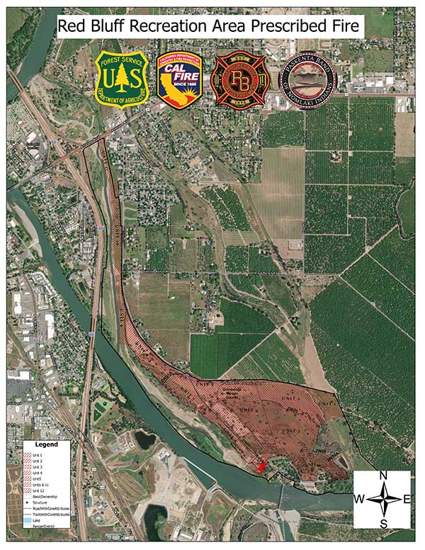
Multiagency prescribed burn planned for Red Bluff Recreation Area June 2021 06 14 2024
Related Incident: Mendocino NF Fall 2023/Spring 2024 RX Fire Projects
Publication Type: News
WILLOWS, Calif., June 13, 2024 – Fire personnel with the Mendocino National Forest’s Grindstone Ranger District are planning an interagency prescribed burn at the Red Bluff Recreation Area on June 20-21, pending favorable weather conditions. Firefighters will attempt up to 400 acres of understory burning to reduce nonnative starthistle. The location of the recreation area is south of Hwy 36 and east of I-5 and within the Red Bluff city limits.
Forest staff are carefully coordinating the 400-acre maintenance burn with partners, including CAL-FIRE Tehama-Glenn Unit, City of Red Bluff Fire Department and the Paskenta Band of Nomlaki Indians.
“The first entry (of prescribed burning) into this area produced an amazing new grass crop, reaching in some areas approximately four feet tall. We also saw the return of native wheat growing in areas of the recreation site,” said Michael Davis, Grindstone Ranger District Fire Management Officer.
“This prescribed fire during fire season would give us the ability to reduce the remaining nonnative yellow starthistle before it can flower and produce seeds. This action will also lesson the possibility of unplanned fires in the recreation area spreading to cooperator lands or vice versa,” said Davis.
In September 2023, interagency firefighters conducted a prescribed burn in the area to protect private residences and business along Sale Lane and provide a training opportunity. Reintroducing low-intensity frequent fire to the area can decrease risk of future wildfire and help restore fire-dependent native plant communities. Fire crews will be working with Paskenta Band of Nomlaki Indians to promote cultural burning practices during the burn.
“Coordination with the Paskenta Band of Nomlaki Indians, as stewards of this territory, is critical to return this area back to pre-contact conditions,” said Laverne Bill, Tribal Historic Preservation Officer.
Fire managers are also coordinating with local landowners in the area to use private roads for containment lines.
Vegetation in the planned units is primarily grass with several small piles of woody debris, shrubs and downed trees. Personnel are timing the burn to help mitigate invasive, nonnative yellow starthistle, which produces buds and flowers in June. Prescribed burning in early summer can help prevent the plant from setting seed later in the season. Firefighters will also protect special ecological and cultural resources, including elderberry plants and gray willows used for basketweaving.
Access to the Red Bluff Recreation Area will be limited, and firefighters ask the public to avoid the area during prescribed fire operations. Smoke may be visible in the city of Red Bluff and along the I-5 corridor. Individuals who are sensitive to smoke are encouraged to take precaution and minimize exposure. For those with a reservation at Camp Discovery or Sycamore Grove campgrounds, an escort will be provided.
The Red Bluff Recreation Area, a popular camping, birding and picnic destination, has seen several fuels reduction and restoration activities over the years, including prescribed fire, goat grazing, pile burning and chipping woody debris to reduce wildfire hazards.
A map and photos of the prescribed burn units are included in this news release. Additional updates about the burn will be shared on the Mendocino National Forest website and social media @MendocinoNF, @CALFIRETGU, @RedBluffFireDepartment and Paskenta Band of Nomlaki Indians.
Bear Fire Update 06 14 2024
Related Incident: Bear Fire
Publication Type: News
Bear Fire
Friday, June 14, 2024
Location of Origin: 5 miles SW of Cibecue, AZ
Start Date: June 8, 2024
Size: 447 acres
Percent Contained: 43%
Cause: Undetermined, Under Investigation
Fuels: Pinyon-Juniper, Grassland
Resources Assigned: 10 Crews, 2 Dozers, 4 Engines, 1 Helicopter, 4 Water Tenders
Operations: Fire behavior was moderated yesterday by cloud cover over the fire area which produced cooler temperatures and higher humidities. Firefighters were able to take advantage of the weather shift, accomplishing additional containment along the eastern flanks. Weather is expected to return to hot and drier conditions today which could result in an increase in fire activity. Firefighters will work to strengthen existing containment lines, extinguish hot spots, and look for opportunities to gain additional containment. The Unmanned Aerial System (UAS) module will aide ground crews in identifying remaining heat sources near the fires perimeter.
Closures: To provide for the safety of the public and firefighters, the G-3 and G-4 roads are closed to the public.
Values at Risk: Emory Oak groves in the area, cultural sites and heritage resources, tribal sensitive species, cattle and grazing, watersheds and riparian areas, woodland areas, the Highway 60 and BIA Route 12 transportation corridors, natural springs, and Cibecue Falls.
Weather: Hot and drier weather is forecast to return with temperatures reaching 93 degrees and winds 10-15 mph.
Smoke: Wildfire smoke may impact Cibecue, Carrizo, and the White Mountain communities. Go to fire.airnow.gov/ to see the latest smoke conditions in your community. Smoke may be visible from the surrounding communities.
Evacuations: There are no evacuations currently. Residents of Cibecue are in “READY” status. The public is encouraged to prepare and follow the Ready, Set, Go! program to prepare for any threats to their community. Go to https://311info.net/ for accurate and timely status updates.
Official fire information can be found on these sites:
• Inciweb: https://inciweb.wildfire.gov/incident-information/azfta-bear-fire
• Facebook: https://www.facebook.com/BIAFAAFireMgt
Interlaken Fire Update 06 14 2024
Related Incident: Interlaken Fire
Publication Type: News
Interlaken Fire Update
June 14, 2024 at 8:00 a.m.
Type 3 Incident Management Team
John Markalunas, Incident Commander
Location: 7 miles S-SW of Leadville, Colorado Date Reported: June 11, 2024 at 2:01pm
Cause: Human caused Size: 585 acres Containment: 5% Total Personnel: 214
SPECIAL ANNOUNCEMENT: There will be a COMMUNITY MEETING about the Interlaken Fire on Saturday, June 15, 10am at the Leadville Lake County Fire Station, 141 CR 10. Video uploaded after. Spanish interpretation available.
Current Situation: Yesterday, fire managers determined there is now 5% containment on the Interlaken Fire, on the NW edge. Late evening Thursday June 13th, there was some fire activity in the NW corner of the fire (“Div A” on the map,) and firefighters worked into the night to ensure successful protection of the historical structures. In Div A, on the north side of the fire, the terrain is steep and full of dead and down lodgepole. The fire is moving slowly through the underbrush in this area, backing down toward Interlaken Trail where firefighters can utilize the trail as fireline and take direct action at the edge of the fire where possible. On the W/SW side of the fire (Div Z on the map,) crews are building direct fireline, connecting it to the 399 Rd. More crews are arriving in this area today to continue building fireline along this W/SW edge of the fire. In Div D on the east side of the fire, more staff are arriving to construct fireline from the 399 Rd west to where Div D meets Div Z. The area where Divisions meet on the map is marked with a )( symbol. In this area, crews are also still gathering intel on locations of structures on private land. Local Search and Rescue crews are assisting firefighters by utilizing boats to bring supplies across the lake to the fire area, and more helicopters are arriving to the fire. Today, there will be two Type 1, two Type 2, and one Type 3 helicopter available for the Interlakan Fire.
Weather: Today the fire area will be partly sunny with a max temperature of 69F and minimum humidity of 25-30%. Winds from the NW 3-10 mph, changing to W and increasing to 10-20. An approaching weather system will bring gusty winds and a chance for showers and thunderstorms to the fire area. Gusty outflow winds up to 45 mph will be possible near any thunderstorms. There could be brief heavy rain and possibly small hail. Thunderstorms should diminish Friday evening with dry and breezy conditions for Saturday. Visit https://www.airnow.gov/wildfires/ for resources on smoke.
Closures: Be aware that several trail, lot, and road closures are in place: Interlaken trailhead and parking area, Willis Gulch trail, Willis Stump Trail, Sheep Gulch trail, Colorado Trail and Continental Divide National Scenic Trail segments in the Twin Lakes Area (from Clear Creek Road to State Route 82), Red Rooster day use area, Moache day use area, Dexter Point day use area and Campground, Deception Point day use, Forest Service Road 399, Forest Service Road 398 and dispersed camping around the lake. The surface area of Twin Lakes is closed. Dexter Point day use area is closed.
Evacuations: Pre-evacuation notices are in place for the Lost Canyon (CR 30), and Chafee County areas north of CR 390 to the county line (Cache Creek, Clear Creek.) To sign up for emergency alerts in Lake County, visit: https://member.everbridge.net/892807736726383/login and in Chaffee County, https://member.everbridge.net/892807736725694/login
Temporary Flight Restrictions: There is a Temporary Flight Restriction (TFR) over the fire area. If you FLY, we CAN’T. Do not fly or operate drones in this area, as it will impede firefighting efforts and ground our aircraft.
Interlaken Fire INFORMATION
Fire Information Phoneline: 719-301-4284 (Time: 7am-7pm) Email: 2024.interlaken@firenet.gov
Facebook: https://www.facebook.com/profile.php?id=61560818226034 (“Interlaken Fire Information”)
InciWeb: https://inciweb.wildfire.gov/incident-information/copsf-interlaken-fire
Snow Ranch Evening Update 06 13 2024
Related Incident:
Publication Type: News
Burnout Operations Complete
Fire start date: June 11, 2024
Fire size today: 323 acres
Location: 11 miles west of Pagosa Springs
Personnel: 100
Cause: Lightning
Closures: The fire area remains closed to public entry. Fire activities will be taking place on both sides of NFSR 681 (Chris Mountain Trail) and fire traffic will be heavy so please avoid this area. Crews expect to reopen access to the road within a few days.
Latest Smoke Outlook: https://fire.airnow.gov/?aqi_v=2&m_ids=&pa_ids=%23
INCIDENT OBJECTIVES:
- Manage hazards to responders and the public using a risk-based approach to decision-making on a continual basis
- Protect critical values at risk
- Reduce the long-term risk to communities from future wildfire events
TODAY’S OPERATIONS:
- Firefighters completed black lining and interior lighting operations using ground and aerial ignition, locking the fire within previously defined indirect boundaries along existing roads and constructed fireline.
TOMORROW’S PLAN:
- Fire crews will patrol and secure the edges of the fireline, holding the fire within the perimeter. A drone will also perform infrared flights for aerial monitoring.
- Smoke is expected to be less visible Friday, though some smoke will continue as interior pockets of unburned fuel, such as pine needles, Gambel oak, and dead and downed trees, continue to smolder and burn.
- A weather disturbance will enter the area, bringing cloud cover and the potential for showers and gusty winds. Relative humidity will be higher than previous days and temperatures cooler.
- Please do not call 9-1-1 to report this fire.
Smoke is visible in the area and it may settle into valleys and other low-lying areas, especially at night and in the early morning hours. Wildfire smoke may affect your health. For more information, please go to: https://www.colorado.gov/pacific/cdphe/wood-smoke-and-health
Los bomberos estn cerca de finalizar el Incendio Antone 06 13 2024
Related Incident: Antone Fire
Publication Type: News
SILVER CITY, NM, 13 de junio del 2024. Los bomberos han realizado un progreso significativo sobre el incendio Antone. Las escuadrillas aseguraran el perímetro de una manera simultanea con igniciones dirigidas en la mitad del área Noreste del incendio. Se continua con la limpieza en la porción Sureste. Actualmente hay 150 personas asignadas en el incidente.
El Guardabosques del Distrito de Quemado dijo que “desafortunadamente el humo es un residuo del incendio y su presencia es inevitable”. Randall Chávez, un originario del lugar, dijo “apreciamos la paciencia y el apoyo del publico mientras los bomberos completaban su trabajo”.
Se han presentado temperaturas cálidas y el nivel de humedad relativa permanece bajo, impactando el comportamiento del incendio. El miércoles, se observó una mancha de incendio en un área de un cuarto de acre. Los bomberos lo detuvieron rápidamente y continuaran patrullando el día de hoy y mañana. También los bomberos se encuentran alertas por las condiciones de clima pronosticadas para el viernes con incrementos de vientos y la posibilidad de tormentas en horas de la tarde.
El Equipo continuara manejando el incendio bajo la estrategia de reducción y contención. Dicha estrategia usa un intercambio de tácticas directas e indirectas de supresión y protección de puntos. Además, esta estrategia está sujeta a cambios basado en las condiciones variables. Los objetivos de manejo incluyen el trabajo continuado de reparación en el área de Slaughter Mesa para reducir las cargas de material de combustión, mejorar el hábitat y proteger recursos valiosos en riesgo.
Se ofrecerán noticias actualizadas cada dos días o si se dan cambios significativos.
La Orden de Cierre No. 03-06-03-24-001 se encuentra en efecto hasta ser revocada. Revise el mapa del cierre marcado en Anexo A. Se pueden encontrar ambos documentos en las alertas del Bosque Nacional Gila y en la pagina red de Cierres en:
https://www.fs.usda.gov/alerts/gila/alerts-notices
Se puede observar el humo desde US Highway 60, NM Highway 12, desde la comunidad de Quemado, Quemado Lake Estates, Pie Town, Datil, Horse Springs, Apache Creek y desde el área de Reserve. Puede encontrar un mapa acerca de la interacción del humo en: https://fire.airnow.gov/. Aprenda más acerca del impacto del humo en: https://www.env.nm.gov/air-quality/fire-smoke-links/
Para más información contacte a Maribeth Pecotte en 575-388-8211 o Maribeth.Pecotte@usda.gov.
USDA Forest Service is an equal opportunity provider, employer, and lender.
Firefighters near completion for the Antone Fire 06 13 2024
Related Incident: Antone Fire
Publication Type: News
SILVER CITY, NM, June 13, 2024 –Firefighters have made substantial progress on the Antone Fire. Crews will be securing the perimeter simultaneously with ignitions being conducted on the northern half of the fire. Mop-up continues on the southern portion. There are currently 150 personnel assigned to the incident.
“Unfortunately, smoke is a byproduct of all fires and sadly it’s unavoidable,” said Quemado District Ranger and long-time local, Randall Chavez. “We appreciate the public’s patience and support while firefighters complete their work.”
The temperatures have been warm, and the relative humidity remains low, impacting fire behavior. A quarter-acre spot fire was observed on Wednesday. Firefighters contained it quickly and will continue patrols today and tomorrow. They are also maintaining heightened awareness for Friday's forecasted increased winds and a chance of thunderstorms in the afternoon.
The type 3 team continues to manage the fire using the confine and contain strategy, which involves the interchangeable usage of direct and indirect suppression and point protection tactics. This strategy is subject to change based on evolving conditions. The management objectives include fire fighter safety, protecting values at risk, reduce fuel loads, improve habitat and the continuation of restoration work in the Slaughter Mesa area. News releases will be provided every other day or if there are significant updates.
Closure Order No. 03-06-03-24-001 is in effect until rescinded. Review the closure order map, marked Exhibit A. Both documents can be found on the Gila National Forest Alerts and Closures webpage at https://www.fs.usda.gov/alerts/gila/alerts-notices
Smoke may be seen from US Highway 60, NM Highway 12, the Community of Quemado, Quemado Lake Estates, Pie Town, Datil, Horse Springs, Apache Creek, and Reserve. View an interactive smoke map at https://fire.airnow.gov/. Learn more about smoke impacts at https://www.env.nm.gov/air-quality/fire-smoke-links/.
More info and links as needed. For more information contact Maribeth Pecotte at 575-388-8211 or Maribeth.Pecotte@usda.gov.
###
USDA Forest Service is an equal opportunity provider, employer, and lender.
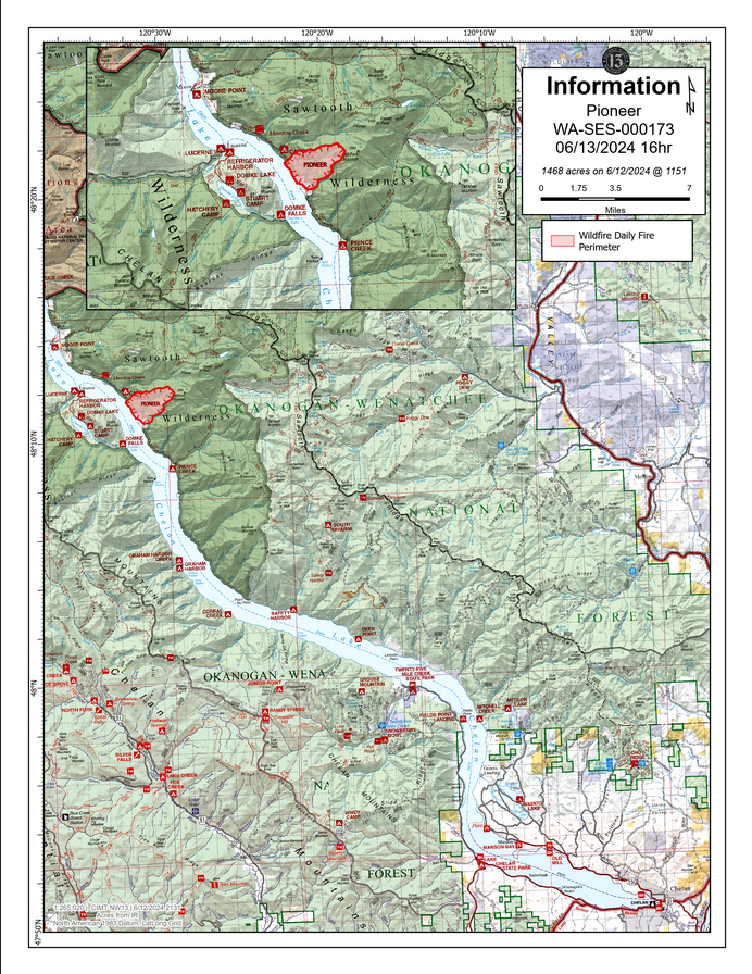
Pioneer Fire Update 06 13 2024
Related Incident:
Publication Type: News
Pioneer Fire Update
Thursday, June 13, 2024
CHELAN, Wash. – The Pioneer Fire is burning in the Lake Chelan-Sawtooth Wilderness Area in the Chelan Ranger District of the Okanogan-Wenatchee National Forest and on private land. Public and firefighter safety are the number one priority for the Okanogan-Wenatchee National Forest, Washington DNR, Chelan County Sheriff’s Office, and Northwest Incident Management Team 13.
In coordination with fire managers, Chelan County Emergency Management has raised the evacuation level from Prince Creek north to Cascade Creek to Level 2 (Be Prepared). A Level 3 (Go Now) evacuation order remains in place for the area around Rex Creek. Please visit https://www.co.chelan.wa.us/emergency-management/pages/active-emergencies for the most current information on evacuations.
As firefighters maintain constructed handlines, hose lays, and sprinklers to protect structures along the lakeshore between Pioneer Creek and Rex Creek, fire officials are working to transport supplies to a Forward Operating Base camp at Lucerne. Crews will camp there, and meals, equipment and supplies will be provided. All personnel and supplies must be transported by boat, barge, or aircraft to the fire area.
Today, the structure protection group will work on establishing protection to homes/cabins from Moore Point to Canoe Creek, reducing ground fuels and creating defensible spaces around private property. Other fire crews are constructing handlines off the Lakeshore Trail to protect structures between Pioneer Creek and Rex Creek. Due to rugged, inaccessible terrain and the large amount of ground fuels, the fire will likely persist on the landscape for an extended duration.
Strategic water drops by aviation resources have helped to slow, but not stop, fire spread along the lake shore. On Wednesday, helicopters dropped 130,000 gallons of water on the fire in support of firefighters on the ground. More aviation resources are expected today, including a drone (Unmanned Aerial System) which will aid in reconnaissance.
Weather: Today will be warm and dry. A dry cold front is expected tonight, bringing cooler temperatures, but humidity levels will remain low, and winds could reach 25 mph. Cooler temperatures will continue over the weekend, with a very slight chance of precipitation.
Closures: A closure order is in effect for the Lakeshore Trail from Prince Creek to Moore Point and portions of the Chelan Sawtooth Wilderness for public safety. The closure includes Prince Creek, Cascade Creek, and Moore Point boat-in campgrounds. Stehekin-bound hikers can be dropped at Moore Point to begin their trip. The closure order and map are posted on the Forest’s website at https://www.fs.usda.gov/detailfull/okawen/alerts-notices/?cid=fseprd521011.
SAFETY: Recreational boaters are asked to maintain space from aircraft utilizing Lake Chelan for water collection. Recreationists are asked to follow the forest closure orders for their safety and the safety of firefighters. Closure details can be found on the link provided above in the closures section.
To continue receiving fire updates, signup for the mailing list at: https://lp.constantcontactpages.com/sl/PndMhvq
Public information:
https://www.facebook.com/profile.php?id=61560760893080
E-mail: 2024.pioneer@firenet.gov
Phone: 509-210-2926 8 a.m.-5 p.m. (7 days a week)
Washington Smoke Blog: https://wasmoke.blogspot.com/
Interlaken Fire Update 06 13 2024
Related Incident: Interlaken Fire
Publication Type: News
Interlaken Fire Update
June 13, 2024 at 1200 p.m.
Type 3 Incident Management Team
John Markalunas, Incident Commander
Location: 7 miles S-SW of Leadville, Colorado Date Reported: June 11, 2024 at 2:01pm Cause: Human caused
Size: 443 acres Containment: 0% Total Personnel: 140
Current Situation: As of yesterday, the Interlaken Fire is being managed by a Type 3 Incident Management Team
(IMT). This team brings a leadership structure and personnel to manage all aspects of the fire including operations, logistics, public information, and other needs. More resources will continue to arrive in the coming days.
Yesterday, aircraft made multiple drops of both water and retardant to check the spread of the fire, and firefighters worked to establish anchor points and engage the fire directly where possible. Operations staff state that yesterday was “a beneficial day of establishing the tactics that will set us up for successful operations in the coming days.” Last night, the Interlaken Fire was active until approximately 1am, mostly burning through understory. There does not appear to have been significant growth, however, new acreage will be assessed soon. Yesterday, on the north end of the fire, crews worked from the Interlaken Historical Site area southeast toward the Continental Divide Trail, building direct line at the fire’s edge. Today, they are scouting for options for fireline in the more difficult terrain where the fire extends uphill and to the ridge. On the south side of the fire, crews are building direct fireline, extending to the southeast. On the southeast side of the fire, firefighters are gathering intel on locations of structures. Helicopters are supporting ground operations with water drops on the northwest corner and the south edge of the fire.
Weather & Smoke Information: Today, June 13, the fire area will be generally warm and dry with max temperature of 77F and humidity falling below 15%. Winds from the west today, 3-12 mph with gusts to 18 mph. There is a small chance of afternoon convective cloudiness over the mountains, which could produce some very brief periods of gusty and erratic winds. Overnight, moisture will increase, with potential for some weak showers overnight, mostly to the north of the fire location. Friday could bring showers and thunderstorms during the afternoon, bringing gusty and erratic winds, but also higher humidity, increasing chance for rainfall. Visit https://www.airnow.gov/wildfires/ for resources on smoke.
Closures: Be aware that several trail, lot, and road closures are in place: Interlaken trailhead and parking area, Willis Gulch trail, Willis Stump Trail, Sheep Gulch trail, Colorado Trail and Continental Divide National Scenic Trail segments in the Twin Lakes Area (from Clear Creek Road to State Route 82), Red Rooster day use area, Moache day use area, Dexter Point day use area and Campground, Deception Point day use, Forest Service Road 399, Forest Service Road 398 and dispersed camping around the lake. The surface area of Twin Lakes is closed. Dexter Point day use area is closed.
Evacuations: Pre-evacuation notices are in place for the Lost Canyon (CR 30), and Chafee County areas north of CR 390 to the county line (Cache Creek, Clear Creek.) To sign up for emergency alerts in Lake County,
visit: https://member.everbridge.net/892807736726383/login and in Chaffee County,
https://member.everbridge.net/892807736725694/login
Temporary Flight Restrictions: There is a Temporary Flight Restriction (TFR) over the fire area. If you FLY, we
CAN’T. Do not fly or operate drones in this area, as it will impede firefighting efforts and ground our aircraft.
Interlaken Fire INFORMATION
Fire Information Phoneline: 719-301-4284 (Time: 7am-7pm) Email: 2024.interlaken@firenet.gov
Facebook: https://www.facebook.com/profile.php?id=61560818226034 (“Interlaken Fire Information”)
InciWeb: https://inciweb.wildfire.gov/incident-information/copsf-interlaken-fire
Pioneer Fire evacuation levels changing 06 13 2024
Related Incident:
Publication Type: Announcement
PIONEER FIRE EVACUATIONS UPDATE: Evacuation levels are changing on the Pioneer Fire, a 1,172-acre fire on the north shore of Lake Chelan that has been burning since June 8.
**The Rex Creek area remains under a Level 3 evacuation. Level 3 (in red) means leave the area immediately.
**There is a Level 2 evacuation notice from the edge of the Rex Creek evacuation area to just past Meadow Creek. Level 2 (in yellow) means prepare now in case you need to evacuate the area in a hurry.
**A Level 1 advisory is in effect from Meadow Creek to past Fish Creek and Moore Point. Level 1 (in green) means stay alert and monitor the fire in the area.
**A Level 1 advisory is also in effect from the edge of the Rex Creek evacuation area to just past Prince Creek.
**In addition, the U.S. Forest Service is closing the Lakeshore Trail from Prince Creek to Moore Point and portions of the Chelan Sawtooth Wilderness. The closure includes Prince Creek, Cascade Creek and Moore Point boat-in campgrounds.
Monitor emergency websites for updates:
Chelan County Emergency Incidents Map: