
Closure Area for the Antone Fire Type 3 IMT Assumes Command 06 11 2024
Related Incident: Antone Fire
Publication Type: News
SILVER CITY, NM, June 11, 2024 – An area closure is in effect for the Antone fire in the Quemado Ranger District, Gila National Forest. “This closure order is necessary to maintain our top priority which is always to protect firefighters and provide for public safety,” said Quemado District Ranger, Randall Chavez. “Active fire and firefighter activity on the ground and in the air require the public to avoid the area so that firefighters can focus on their operations.”
The closure order is identified at the intersection of Catron County (CAT) Road A095, also known as Mangas Road, and National Forest System Road (NFSR) 13 west 7.2 miles to the intersection of NFSR 13 and NFSR 93 north for 12 miles to the junction with NFSR 93 and CAT Road A095, south 7.3 miles back to the junction of CAT Road A095 and NFSR 13. This includes a portion of the Continental Divide Trail and Valla Tio Vince Campground.
Closure Order No. 03-06-03-24-001 is in effect until rescinded. Review the closure order map, marked Exhibit A. Both documents can be found on the Gila National Forest Alerts and Closures webpage at https://www.fs.usda.gov/alerts/gila/alerts-notices
At the end of shift on Monday, the Antone fire was at 2,645 acres with 105 personnel assigned and the fire continues to primarily burn in ponderosa pine and some mixed conifer. The cloud cover assisted in moderate fire activity as work was conducted on the entire perimeter with some crews performing firing operations on the southeast side while other resources prepped the remaining exterior areas of the fire for future ignitions.
A type 3 incident management team assumed command of the fire Tuesday morning. The team will continue to manage the fire under the confine and contain strategy which is the interchangeable usage of direct and indirect suppression and point protection tactics. This strategy is subject to change based on changing conditions. Management objectives include the continuation of restoration work in the Slaughter Mesa area to reduce fuel loads, improve habitat, and protect values at risk. The planned area for the Antone fire is just over 12,000 acres.
There is less cloud cover today (Tuesday) and over the next couple of days which will make the fire more active and most likely more visible. Firefighter resources will continue with firing operations along the outer boundary while other crews continue exterior perimeter prep work. News releases will be provided every two days or if there are significant updates.
Smoke may be seen from US Highway 60, NM Highway 12, the Community of Quemado, Quemado Lake Estates, Pie Town, Datil, Horse Springs, Apache Creek, and Reserve. View an interactive smoke map at https://fire.airnow.gov/. Learn more about smoke impacts at https://www.env.nm.gov/air-quality/fire-smoke-links/.
For more information contact Maribeth Pecotte at 575-388-8211 or Maribeth.Pecotte@usda.gov.
###
USDA Forest Service is an equal opportunity provider, employer, and lender.
Bear Fire Update 06 11 2024
Related Incident: Bear Fire
Publication Type: News
Bear Fire
Tuesday, June 11, 2024
Location of Origin: 5 miles SW of Cibecue, AZ
Start Date: June 8, 2024
Size: 446 acres
Percent Contained: 0%
Cause: Undetermined, Under Investigation
Fuels: Pinyon-Juniper, Grassland
Resources Assigned: 6 Crews, 1 Dozer, 4 Engines, 1 Helicopter, 4 Water Tenders
Operations: The Bear Fire is burning in rugged terrain and has thus far provided only minimal access to firefighting resources. Increased temperatures and lower humidities resulted in 30-acres of new fire growth across retardant lines yesterday. Additionally, three new fires started approximately 1 mile from the northern most edge of the main fire yesterday. The three new fire starts have been collectively designated as the Black Fire and will also be managed by the White Mountain Zone Incident Management Team. Firefighters will continue to look for access points to safely engage along the flanks of the Bear Fire today, and aerial resources will continue to be deployed to aid firefighting efforts on the ground.
Closures: To provide for the safety of the public and firefighters, the G-3 and G-4 roads are closed to the public.
Evacuations: There are no evacuations currently. Residents of Cibecue are in “READY” status. The public is encouraged to prepare and follow the Ready, Set, Go! program to prepare for any threats to their community. Go to https://311info.net/ for accurate and timely status updates.
Values at Risk: Emory Oak groves in the area, cultural sites and heritage resources, tribal sensitive species, cattle and grazing, watersheds and riparian areas, woodland areas, the Highway 60 and BIA Route 12 transportation corridors, natural springs, and Cibecue Falls.
Weather: Hot, dry weather is expected to continue with temperatures reaching 96 degrees and winds 5-10 mph.
Smoke: Wildfire smoke may impact Cibecue, Carrizo, and the White Mountain communities. Go to fire.airnow.gov/ to see the latest smoke conditions in your community. Smoke may be visible from the surrounding communities.
Official fire information can be found on these sites:
• Inciweb: https://inciweb.wildfire.gov/incident-information/azfta-bear-fire
• Facebook: https://www.facebook.com/BIAFAAFireMgt
Pioneer Fire evacuation trail closure information 06 11 2024
Related Incident:
Publication Type: Announcement
Chelan County Emergency Management maintains Level 3 (Go Now) evacuation orders for the area around Rex Creek and Level 1 (Be Ready) orders extending from Prince Creek north to Cascade Creek. Please visit https://www.co.chelan.wa.us/emergency-management/pages/active-emergencies for the most current information on evacuations.
The Lakeshore Trail is unusable between Prince Creek and Meadow Creek. Do not attempt to hike in this area due to fire danger.
BighornStateline Prescribed Burn Postponed 06 11 2024
Related Incident:
Publication Type: News
LAJARA, Colo., June 11, 2024 – The Conejos Peak Ranger District announced today that the planned Bighorn/Stateline prescribed burn has been postponed for approximately two weeks. The district is pleased to have received the beneficial moisture from the last storm. However, it was significantly more moisture than anticipated when we announced the planned burn on June 6, 2024.
“The project is targeting slash ‘jackpots’ and we were hoping for a little rain to moderate the projected burn intensity,” said Acting District Ranger, Judi Perez. “Unfortunately, the fickle nature of weather in the mountains has dumped nearly four times the amount of rain needed, now making the fuels too wet to meet project objectives.”
The Conejos Peak Ranger District will advise the public when conditions become more favorable and planning for the prescribed fire resumes.
###
USDA is an equal opportunity provider, employer and lender.
Daily Update 06 11 2024
Related Incident: Indios Wildfire
Publication Type: News
Acres: 11,500
Start Date: May 19, 2024
Location: 7 miles north of the village of Coyote, NM
Personnel: 186
Fuels: Timber
Completion: 86%
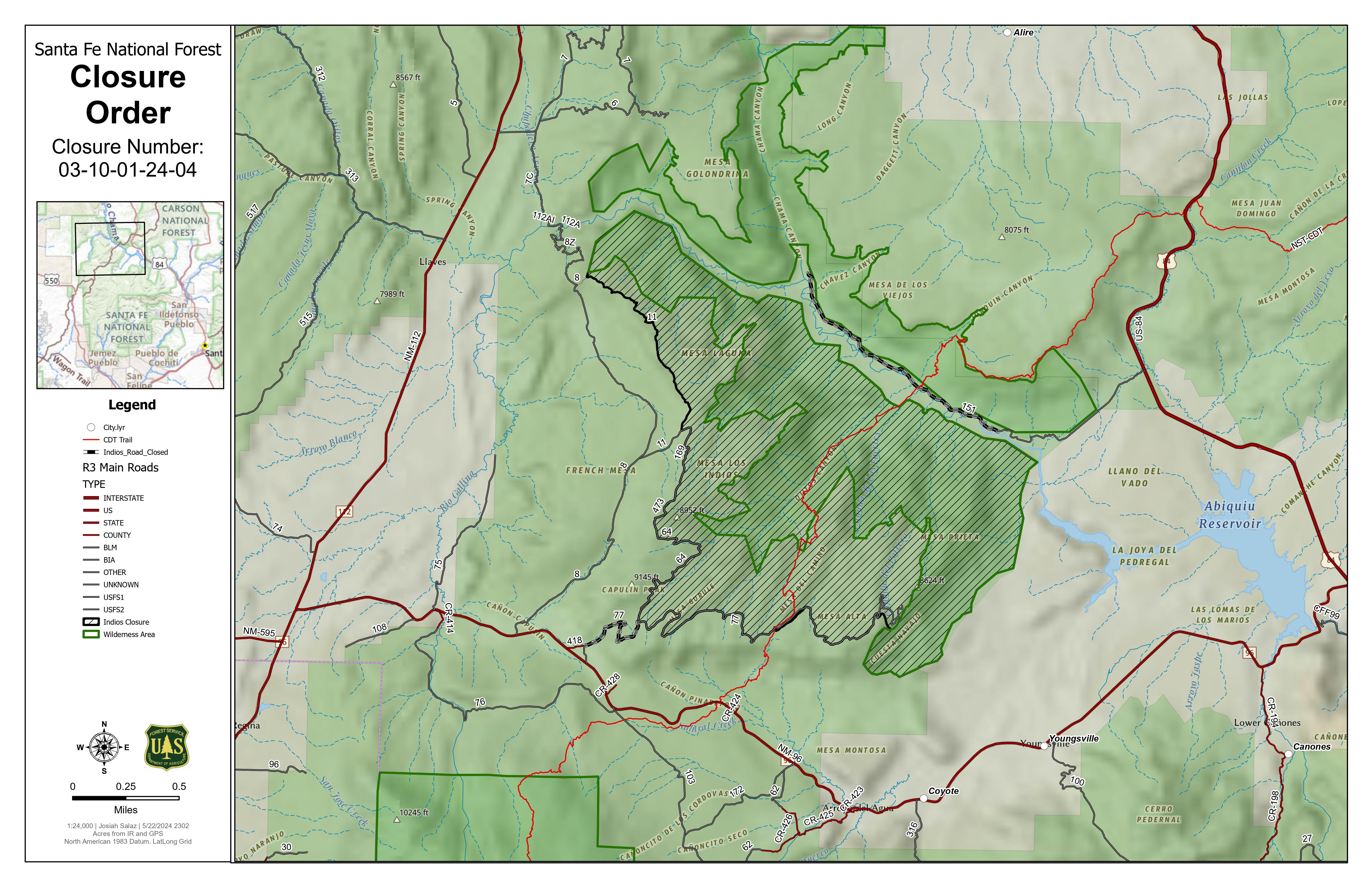
Highlights: The Northern New Mexico Type 3 Incident Management team, led by Incident Commander Luke McLarty, took command of the Indios Fire on Monday, June 10, from the Southwest Area Incident Management Team 4. The Northern New Mexico team is comprised of members from the Santa Fe National Forest and surrounding areas. They had command of the fire for the first several days of the incident before transitioning to the SWIMT 4. The type 3 team will now finish suppression repair work, mop up and cool interior hot spots, and assess the Continental Divide Trail to determine the next steps in getting it opened back up.
Due to successful firefighting efforts, 86% of objectives are complete, and many resources are either demobilizing to return to their home units or reassigning to assist other wildfires across the country. As a result of decreased fire activity, written updates will now be provided every other day moving forward.
Operations: Today, Forest personnel will conduct a reconnaissance of the Continental Divide Trail from top to bottom of the closed portion to determine what is needed to make it safe to open it back up to hikers. Hydrologists will assess the burn area to decide what repairs and rehabilitation work may be needed to protect the watershed.
The percentage of completion (objectives for confinement, point protection, and monitoring) and containment (where the fire can be reasonably expected to stop spreading) remains at 86%, and no further fire growth is expected. The remaining 14% is not officially reported as contained because no control measures are in place on the northern end of the fire due to steep, inaccessible terrain in the Chama River Canyon Wilderness. Fire managers expect little to no fire spread in this area due to the limited vegetation and rocky terrain. Large logs and stumps continue to smolder in some areas, but most lighter fuels have been consumed in the interior.
Fire personnel, including firefighters, heavy equipment operators and Forest personnel continue with suppression repair work. This includes repairing roads and firelines, installing water bars, seeding disturbed areas, chipping, and cutting down trees that pose a hazard (snags) along roads and trails.
Weather: Today, the skies will clear, and temperatures will rise. A spot shower or thunderstorm moving southeast from the Tusas Mountains north of the burn location is unlikely to hit the burn area directly, but gusty outflow winds could impact the area in the afternoon and early evening.
Smoke: Minimal smoke impacts are expected for the foreseeable future. Light dispersed visible smoke will diminish over time. Smoke sensors have been installed and will remain in the communities of Coyote, Gallina, Cañones, and at the Monastery of Christ in the Desert. View an interactive smoke map at https://fire.airnow.gov/. Learn more about smoke impacts at https://www.env.nm.gov/air-quality/fire-smoke-links/.
Closures: A Santa Fe National Forest emergency area closure is in place for the Indios Fire. The full closure order (No. 03-10-01-24-04) and map are available on Inciweb. Perimeter modifications to the closure order were made on Monday, June 10. Camping and water are available at the Coyote Ranger Station for Continental Divide Trail hikers impacted by this closure.
Fire Information:
575-323-2290
Closure Order 0310012404 06 10 2024
Related Incident: Indios Wildfire
Publication Type: Closures
.jpg)
The Forest Closure Order was lifted on June 17, 2024.
Daily Update Source of Heat Identified and Mitigated for Firefighter Safety on the Blue 2 Fire 06 11 2024
Related Incident: Blue 2 Fire
Publication Type: News
Source of Heat Identified and Mitigated for Firefighter Safety on the Blue 2 Fire
Daily Update: June 11, 2024
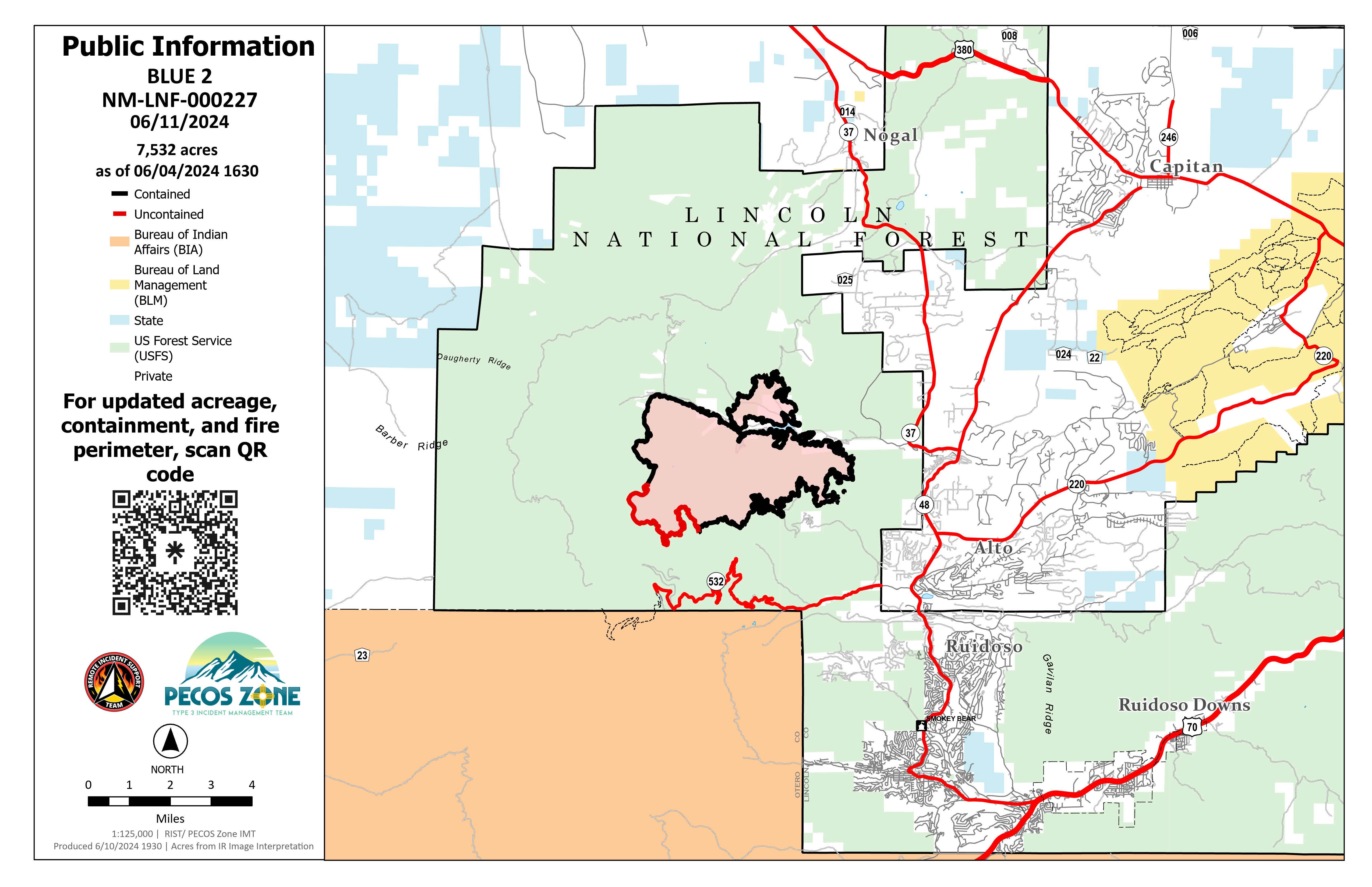
Acres: 7,532
Start Date: May 16, 2024
Location: 8 miles North of Ruidoso, White Mountain Wilderness Area Cause: Lightning
Personnel: 135
Fuels: Timber/Grass/Brush
Containment: 88%
Resources: 1 Crew | 2 Engines | 3 Water Tenders | 2 Masticators
Operations: Yesterday, firefighters were able to gain access near the fire perimeter north of Buck Mountain on foot and identified an ash pit as the source of smoke that was previously visible. Ash pits are created when a fire begins to consume underground fuels. These pits present hazards for firefighters because they create a superheated ash-filled space, often indistinguishable from the surface. Firefighters can fall into the ashpits and experience significant burn injuries. For firefighter safety, unmanned aircraft system (UAS) pilots will continue to monitor the area for heat sources toward the uncontained perimeter of the fire as direct access continues to be difficult. Contingency lines have been constructed that surround the uncontained perimeter in a safer and more accessible area for firefighters to work in. A grader and mini excavator arrived to help firefighters with repair and mastication along the eastern contingency line working west toward Loma Grande. Dozer lines are also being repaired inside Soldier Mountain by crews filling lines with brush to return constructed lines to a more natural state. Backhaul of the excess equipment from the completed sections of the fire will continue throughout the week. Law enforcement will keep a presence to enforce the forest closure so firefighters can safely complete their work.
Weather: Yesterday, the fire area experienced small amounts of moisture from nearby showers and storms. Storms may bring dry lightning, gusty and erratic winds, rain, and even small hail. Today, a warming and drying trend is forecast through the rest of the week as high pressure builds over the region. Fire behavior is expected to be minimal smoldering in the few areas with a heat source interior to the fire perimeter.
Smoke: Smoke from the fire's interior can produce limited smoke throughout the day that may impact the surrounding areas, which depend on wind. The interactive smoke map can still be found at fire.airnow.gov/
Closures: Due to ongoing firefighter activities, the Bonito Lake Area is still restricted in the interest of public safety. The Forest closure order will remain in effect for the White Mountain Wilderness Area.
Evacuations: All evacuation statuses have been lifted. For an interactive evacuation map, go to tinyurl.com/Blue2Evacs
Bear Fire Update 06 10 2024
Related Incident: Bear Fire
Publication Type: News
Location of Origin: 5 miles SW of Cibecue, AZ
Start Date: June 8, 2024
Size: 438 acres
Percent Contained: 0%
Cause: Undetermined, Under Investigation
Fuels: Pinyon-Juniper, Grassland
Resources Assigned: 6 Crews, 2 Dozers, 4 Engines, 1 Helicopter, 4 Water Tenders
The Bear Fire has increased in size and complexity, and the White Mountain Zone Type 3 Incident Management Team assumed command at 7:00 a.m. on Monday, June 10, 2024.
Operations: Aerial resources have been crucial in slowing the progress of the Bear Fire. Helicopters and other aerial resources will continue that effort in today’s operations. Weather is expected to trend towards hotter and drier conditions today, and firefighting crews will look to engage directly in suppression efforts, but only when it is safe to do so.
Safety: Wildfire smoke may impact Cibecue, Carrizo, and the White Mountain communities. The public is encouraged to prepare and follow the Ready, Set, Go! program to prepare for any threats to their community.
Evacuations: There are no evacuations currently. Residents of Cibecue are in “READY” status. Go to https://311info.net/ for accurate and timely status updates.
Closures: To provide for the safety of the public and firefighters, the G-3 and G- 4 roads are closed to the public.
Values at Risk: Emory Oak groves in the area, cultural sites and heritage resources, tribal sensitive species, cattle and grazing, watersheds and riparian areas, woodland areas, the Highway 60 and BIA Route 12 transportation corridors, natural springs, and Cibecue Falls.
Weather: Today’s forecast calls for mostly sunny skies with a high of 91 degrees and winds 5-10 mph.
Smoke: Go to fire.airnow.gov/ to see the latest smoke conditions in your community. Smoke may be visible from the surrounding communities.
Official fire information can be found on these sites:
Settings - change map background and toggle additional layers
Filter - control incident types displayed on map.
Zoom to your location
Reset map zoom and position
Could not determine your location.
Show Legend
 Wildfire
 Prescribed Fire
 Burned Area
Response
Burned Area
Response Other
Other
Bear Fire
Unit Information
Incident Contacts
BAER Team completes soil burn severity map for Blue 2 Fire June 10 2024 06 10 2024
Related Incident: Blue 2 Fire Post-Fire BAER
Publication Type: News
BAER team completes Soil Burn Severity map for Blue 2 Fire
RUIDOSO,NM, June 10, 2024 – Forest Service Burned Area Emergency Response (BAER) specialists recently completed their field data evaluation to produce the Soil Burn Severity (SBS) map for the Blue 2 Fire, which field verifies unburned/very low, low, moderate, and high SBS categories from satellite imagery.
The SBS map estimates approximately 2,135 acres (28%) of the fire is unburned/very low, approximately 4,486 acres (64%) have low soil burn severity, and approximately 602 acres (8%) sustained a moderate SBS. No portion of the fire was identified as having high SBS.
The SBS map product is an estimate of fire effects to soils, not fire effects to vegetation. SBS characterizes fire effects to the soil surface and below ground. Fire effects to vegetation would include an estimate of vegetation mortality and does not always correlate with degree of soil burn severity.
Moderate and high soil burn severity can alter or damage physical, chemical, and biological soil properties resulting in increased runoff, erosion, and negative effects to soil productivity. These soil properties include but are not limited to soil cover (effective litter), soil organic matter content, hydrophobicity (water repellency), soil pore space, and soil structure (degree of aggregation).
Changes to these soil properties determine the degree of soil burn severity. Loss of effective ground cover, especially on steep slopes, greatly increases probability of soil erosion and increased runoff.
The Blue 2 BAER team used remote sensing imagery with field-validated soils data to produce the final SBS map. The BAER team will use the SBS map as an analysis tool to estimate post-fire erosion with subsequent sediment delivery, stream flows and debris flow probabilities. The map is also being shared with cooperating agencies.
The Blue 2 Fire soil burn severity map can be downloaded from Inciweb at Nmlnf Blue 2 Fire Postfire Baer Information | InciWeb (wildfire.gov) as a JPEG or PDF version under the Maps tab.
BAER SAFETY MESSAGE: Everyone near and downstream from the burned areas should remain alert and stay updated on weather conditions that may result in heavy rains and increased water runoff. Flash flooding may occur quickly during heavy rain events be prepared to act. Current weather and emergency notifications can be found at the National Weather Service website: www.weather.gov/abq/.