
Actualizacin del incendio de Interlaken 15 de junio 2024 a las 800 am 06 15 2024
Related Incident: Interlaken Fire
Publication Type: News
Actualización del incendio de Interlaken
15 de junio, 2024 a las 8:00 a.m.
Equipo de Gestión de Incidentes Tipo 3
John Markalunas, Comandante de Incidente
Ubicación: 7 millas S-SW de Leadville, Colorado Fecha de reporte: 11 de junio de 2024 a las 2:01 pm
Causa: Causada por humanos Tamaño: 592 acres Contención: 15% Personal total: 277
Reunión comunitaria AHORA: 10 a.m. en la Estación de Bomberos del Condado de Leadville Lake, 141 CR 10.
Situación Actual: La contención del incendio de Interlaken es ahora 15%, y se espera que aumente en los próximos días. Ayer, los bomberos aprovecharon el clima más fresco y, por lo tanto, el comportamiento moderado del incendio, para continuar construyendo la línea justo en el borde del incendio, logrando avances significativos. En el norte, en la División A, el fuego sigue avanzando lentamente a través de los combustibles del suelo, acercándose al sendero de Interlaken, donde los bomberos podrán utilizar el sendero como línea de fuego. En la División Z, los bomberos completaron la línea de fuego directa a lo largo de todo el borde suroeste del incendio. Hoy, los bomberos en esta área mejorarán y asegurarán esta línea, y los helicópteros traerán "cargas de eslingas" de bombas de agua y mangueras para ayudar con esos esfuerzos. El personal de la División D en el lado sureste continúa construyendo una línea de mano directa en el borde del incendio. En el lado este, cerca de la ruptura de la División D y la División A, el fuego ha ardido en el borde de una quema previamente prescrita de 2018: la quema prescrita de Flume Creek. La eficacia de este proyecto prescrito se ha hecho extremadamente evidente; Está actuando como una característica de espera y el fuego se ha ralentizado o detenido en esta área, lo que permite a los bomberos obtener acceso directo y ayudar a prevenir la propagación hacia las comunidades del este.
Una nota sobre el humo: Los impactos siguen siendo mínimos cerca del incendio de Interlaken. Se espera que los vientos y la buena mezcla atmosférica alejen el humo de la superficie el sábado, lo que provocará impactos mínimos en la salud pública. Es posible que persistan concentraciones de humo de ligeras a moderadas en terrenos más bajos en áreas cercanas a Twin Lakes, particularmente durante la noche y las primeras horas de la mañana. (https://www.colorado.gov/airquality/colo_smoke.aspx) Visite https://www.airnow.gov/wildfires/ para obtener recursos sobre el humo.
Clima: Soleado hoy, temperaturas máximas de 72F con humedad del 16-21%. Los vientos volverán a aumentar (del NW de 4 a 8 mph y luego del W a 12 mph con ráfagas de 22 mph). Hay una ligera probabilidad de chubascos y tormentas eléctricas por la tarde y la noche. Se esperan vientos racheados y erráticos cerca de cualquier tormenta eléctrica después de las 3 p.m. El domingo volverán las condiciones cálidas, secas y ventosas, con niveles de humedad que caerán por debajo del umbral crítico del 15%. Esto podría crear condiciones climáticas críticas para los incendios.
Evacuaciones: Hay avisos previos a la evacuación para las áreas de Lost Canyon (CR 30) y el condado de Chafee al norte de CR 390 hasta la línea del condado (Cache Creek, Clear Creek). Para inscribirse para recibir alertas de emergencia en el condado de Lake, visite: https://member.everbridge.net/892807736726383/login y en el condado de Chaffee, https://member.everbridge.net/892807736725694/login
Restricciones temporales de vuelo: Existe una restricción temporal de vuelo (TFR) sobre el área del incendio. Si tú VUELAS, nosotros NO PODEMOS. No vuele ni opere drones en esta área, ya que impedirá los esfuerzos de extinción de incendios y dejará en tierra nuestras aeronaves.
INFORMACIÓN sobre el Incendio Interlaken
Línea telefónica de información: 719-301-4284 (hora: 7 a.m. a 7 p.m.) Correo electrónico:2024.interlaken@firenet.gov
Facebook: https://www.facebook.com/profile.php?id=61560818226034 ("Información sobre el incendio de Interlaken")
InciWeb: https://inciweb.wildfire.gov/incident-information/copsf-interlaken-fire
Daily Update 06 15 2024
Related Incident: Indios Wildfire
Publication Type: News
Acres: 11,500
Start Date: May 19, 2024
Location: 7 miles north of the village of Coyote, NM
Personnel: 108
Completion: 90%
Fuels: Timber
Highlights: Thunderstorms and the associated rain and wind hampered Friday's suppression repair operations. Crews came off the mountain early due to safety issues associated with lightning. However, the moisture helped cool areas of the fire that have continued to smolder. As temperatures warm up and fuels dry out over the next few days, some smoke may become visible again.
Operations: Firefighters, heavy equipment operators, and Forest staff continue with suppression repair work. A grader will help spread gravel along several roads as repairs continue. Fire personnel are making drainage improvements on various roads and firelines. Chipping continues in some areas, and crews are still cutting down hazardous trees.
A Burned Area Emergency Response (BAER) team is assessing the burn severity of the fire. BAER teams are staffed by specially trained professionals: hydrologists, soil scientists, engineers, biologists, vegetation specialists, archeologists, and others who evaluate the burned area and prescribe stabilization treatments. In areas of higher fire severity, the priority is stabilization to prevent further damage to natural resources. While a large percentage of this fire had desirable effects due to low to moderate intensity, the BAER team is still assessing areas of higher intensity fire that may need stabilization to prevent erosion, increased flood risk, and stream, river, and reservoir sedimentation.
Weather: Between .25 and .75 inches of rain fell over the fire area Friday afternoon, prompting a Flash Flood warning issuance. Breezy west winds on Saturday will create a warming and drying trend. Sunday will be hotter, drier, and breezier than Saturday, creating elevated to near-critical fire weather conditions.
Smoke: Minimal smoke impacts are expected for the foreseeable future. Learn more about smoke impacts at https://www.env.nm.gov/air-quality/fire-smoke-links/.
Closures: A Santa Fe National Forest emergency area closure is in place for the Indios Fire. The full closure order (No. 03-10-01-24-04) and map are available on Inciweb. Camping and water are available at the Coyote Ranger Station for Continental Divide Trail hikers impacted by this closure.
Inciweb: inciweb.wildfire.gov/incident-information/nmsnf-indios-wildfire
New Mexico Fire Info: nmfireinfo.com
Indios Fire Phone: 575-323-2290
Indios Fire Email: 2024.indios@firenet.gov
Santa Fe National Forest X: x.com/SantafeNF
Santa Fe National Forest Facebook: facebook.com/santafe
Interlaken Fire Update 06 15 2024
Related Incident: Interlaken Fire
Publication Type: News
Interlaken Fire Update
June 15, 2024 at 8:00 a.m.
Type 3 Incident Management Team,
John Markalunas, Incident Commander
Location: 7 miles S-SW of Leadville, Colorado Date Reported: June 11, 2024 at 2:01pm
Cause: Human caused Size: 592 acres Containment: 15% Total Personnel: 277
Community Meeting TODAY: 10am at Leadville Lake County Fire Station, 141 CR 10.
Current Situation: Containment on the Interlaken Fire is now 15%, with more expected in the coming days. Yesterday, firefighters took advantage of the cooler weather, and thus the moderated fire behavior, to continue building line right at the edge of the fire, making significant progress. In the north, in Div A, the fire keeps creeping slowly through the ground fuels, approaching the Interlaken Trail where firefighters will be able to utilize the trail as fireline. In Div Z, firefighters completed direct fireline along the entire SW edge of the fire. Today, firefighters in this area will improve and secure this line, and helicopters will bring “sling loads” of water pumps and hoses to assist with those efforts. Staff in Div D on the SE side continue building direct handline at the fire’s edge. On this east side, near the Div D and Div A break, the fire has burned into the edge of a previously prescribed burn from 2018 - the Flume Creek Prescribed Burn. The efficacy of this prescribed project has become extremely evident; it is acting as a holding feature and the fire has slowed or stopped in this area, allowing firefighters to gain direct access and help prevent spread toward communities to the east.
A note on smoke: Impacts continue to be minimal near the Interlaken Fire. Winds and good atmospheric mixing are expected to loft smoke away from the surface on Saturday, resulting in minimal public health impacts. Light to moderate concentrations of smoke may linger in lower terrain in areas near Twin Lakes, particularly during the overnight and early morning hours. (https://www.colorado.gov/airquality/colo_smoke.aspx) Visit https://www.airnow.gov/wildfires/ for resources on smoke.
Weather: Sunny today, max temps 72F with humidity 16-21%. Winds will pick up again (from NW 4-8 mph then from W at 12 mph gusting to 22 mph.) There is a slight chance of afternoon and evening showers and thunderstorms. Gusty and erratic winds expected near any thunderstorms after 3pm. Sunday will bring a return to hot, dry, windy conditions with humidity levels dropping below the critical 15% threshold. This could create critical fire weather conditions.
Closures: Be aware that several trail, lot, and road closures are in place. As of 6-14-24, there is an official order from the Forest Service. Refer to the PSICC website and check under FIRE RESTRICTIONS AND FOREST ORDERS on the main page. See closure map here: https://www.fs.usda.gov/Internet/FSE_DOCUMENTS/fseprd1181393.pdf, and closure order here: https://www.fs.usda.gov/Internet/FSE_DOCUMENTS/fseprd1181392.pdf
Evacuations: Pre-evacuation notices are in place for the Lost Canyon (CR 30), and Chafee County areas north of CR 390 to the county line (Cache Creek, Clear Creek.) To sign up for emergency alerts in Lake County, visit: https://member.everbridge.net/892807736726383/login and in Chaffee County, https://member.everbridge.net/892807736725694/login
Temporary Flight Restrictions: There is a Temporary Flight Restriction (TFR) over the fire area. If you FLY, we CAN’T. Do not fly or operate drones in this area, as it will impede firefighting efforts and ground our aircraft.
Interlaken Fire INFORMATION
Fire Information Phoneline: 719-301-4284 (Time: 7am-7pm) Email: 2024.interlaken@firenet.gov
Facebook: https://www.facebook.com/profile.php?id=61560818226034 (“Interlaken Fire Information”)
InciWeb: https://inciweb.wildfire.gov/incident-information/copsf-interlaken-fire
Snow Ranch Evening Update 06 14 2024
Related Incident:
Publication Type: News
Firefighters Hold the Line
Fire start date: June 11, 2024
Fire size today: 386 acres
Location: 11 miles west of Pagosa Springs
Personnel: 85
Cause: Lightning
Containment: 29%
Closures: The fire area remains closed to public entry. Fire activities will be taking place on both sides of NFSR 681 (Chris Mountain Trail) and fire traffic will be heavy so please avoid this area. Crews expect to reopen access to the road within a few days.
Latest Smoke Outlook: https://fire.airnow.gov/?aqi_v=2&m_ids=&pa_ids=%23
INCIDENT OBJECTIVES:
- Manage hazards to responders and the public using a risk-based approach to decision-making on a continual basis
- Protect critical values at risk
- Reduce the long-term risk to communities from future wildfire events
TODAY’S OPERATIONS:
- Fire crews patrolled and mopped up and secured the edges of the fireline, holding the fire within the perimeter.
- A drone performed infrared flights for aerial monitoring and no spot fires were found outside the containment lines.
- Sawyers worked to remove hazard trees that posed a threat to safety or that could fall across the fireline.
TOMORROW’S PLAN:
- Firefighters will continue to mop up and patrol the fireline, as well as remove fire-weakened trees that may otherwise fall across roads.
- Fire managers will begin making plans for rehabilitation of dozer line and other disturbed areas.
- Smoke will remain visible from Highway 160 and Pagosa Springs as interior pockets of unburned fuel, such as pine needles, stumps, and dead and downed trees, smolder and burn.
- Please do not call 9-1-1 to report this fire.
WEATHER:
The fire received slight precipitation on Friday resulting in less active fire behavior overall. A drying trend is expected throughout the weekend and into next week.
Smoke will settle into valleys and other low-lying areas, especially at night and in the early morning hours. Wildfire smoke may affect your health. For more information, please go to: https://www.colorado.gov/pacific/cdphe/wood-smoke-and-health
Rose Fire Update for Friday June 14 2024 06 14 2024
Related Incident: Rose Fire
Publication Type: News
The fire continues to hold within containment lines including through afternoon winds with gusts up to 20 mph. Even with Friday’s hot and dry conditions fire behavior stayed low to moderate with heat lingering within the interior of the fire, particularly within the Hassayampa Riverbed.
Today, crews remained engaged with heavy mop up, working along the fire’s edge ensuring no heat remains. The process of mopping up requires firefighters to suppress vegetation and remove large material still burning along the fire’s edge and extinguishing it down into the mineral soil. Mopping up ensures fire cannot move outside of containment lines into unburned areas of the fire. Four Department of Forestry and Fire Management hand crews along with two Interagency Hotshot crews continue their efforts direct along the fire line. As of today, the fire is 70% contained at 166 acres.
Arizona Public Service restored power today to residents living along the south side of the impacted fire area, near the Hassayampa River. However, fire operations said gas is not expected to be turned on for a few days. Residents who utilize Southwest Gas should contact the gas company for further updates as to when gas can be restored. On Saturday, fire operations will begin demobilizing resources to make them available for any new starts within the area or throughout the state.
The Rose Fire started Wednesday, June 12, 2024, within the Hassayampa Riverbed, along the east side of the US 60, five miles southeast of the town of Wickenburg. Hot, windy and dry conditions fueled the fire as it burned through salt cedar, grass and brush. The fire stayed active throughout the late afternoon, jumped the highway, and started burning along both sides of the 60. The fire spotted along the north flank of the fire, but firefighters were able to catch and contain those spot fires. Numerous firefighting aircraft supported firefighting efforts on the ground Wednesday, including Single Engine Air Tankers, Very Large Air Tankers, and Scoopers.
Maricopa County residents are encouraged to sign up for emergency alerts at: https://www.maricopa.gov/1755/CENS.
Rose Fire Update for Thursday June 13 2024 06 13 2024
Related Incident: Rose Fire
Publication Type: News
Today firefighters engaged with line construction and going direct along the fire’s edge, when and where it is safe. A helicopter with the Bureau of Land Management continued to support ground resources with bucket drops on lingering hot spots. Along the northeast and southeast sides of the fire, crews were able to get containment lines established and now have the fire 20% contained. It remains 166 acres per an aerial flight earlier today. Fire operations were able to engage the dozer this afternoon, within the river bottom, along the northwest flank of the fire. Dozer work provides for faster suppression efforts in the dense vegetation found within the riverbed. Precautionary efforts are being taken to ensure there is no adverse action within the riparian areas. Engine crews are patrolling around the communities to finish with structure protection. A fire investigator arrived on the incident today and the fire remains under investigation.
Rose Fire overhead along with Maricopa County officials conducted a property damage assessment on Thursday. In total, 15 structures were destroyed, seven of which were primary residences. Twelve vehicles, a horse trailer, and a recreational vehicle were also destroyed in the fire. On Thursday, per Maricopa County Department of Emergency Management (MCDEM) the GO and SET statuses were lifted for impacted residents. However, after continuous evaluation with the Wickenburg Police Department and the fact that gas and electricity remain off to the south side, near the Hassayampa River, residents are asked to give time for utilities to be restored prior to reentering. Fire management along with local authorities will continue to reevaluate the power situation and determine when it would be safe to restore those utilities.
The Rose Fire started Wednesday afternoon, within the Hassayampa Riverbed, along the east side of the US 60, five miles southeast of the town of Wickenburg. Hot, windy and dry conditions fueled the fire as it burned through salt cedar, grass and brush. The fire stayed active throughout the late afternoon, jumped the highway, and started burning along both sides of the 60. The fire spotted along the north flank of the fire, but firefighters were able to catch and contain those spot fires. Numerous firefighting aircraft supported firefighting efforts on the ground yesterday, including Single Engine Air Tankers, Very Large Air Tankers, and Scoopers.
Maricopa County residents are encouraged to sign up for emergency alerts at: https://www.maricopa.gov/1755/CENS.
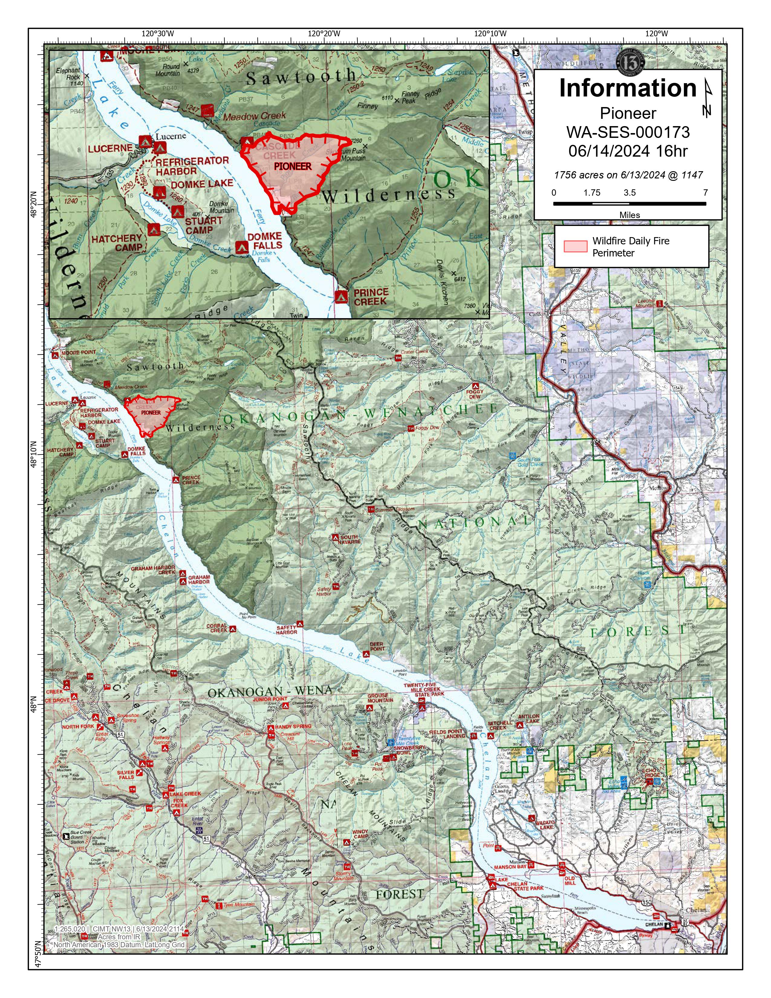
Pioneer Fire Update 06 14 2024
Related Incident:
Publication Type: News
Pioneer Fire Update
Friday, June 14, 2024
CHELAN, Wash. - Firefighters continue to build line and protect structures while fire managers develop a longer-term strategy for combating the Pioneer Fire, which is burning in the Lake Chelan-Sawtooth Wilderness Area in the Chelan Ranger District of the Okanogan-Wenatchee National Forest and on private land.
Thursday, aviation resources flew missions to deliver 31 passengers into the fire zone and dropped 105,000 gallons of water to slow the fire’s movement and support firefighters on the ground. Aerial operations consisted of supply drops, logistical assessments, cargo deliveries, and reconnaissance. A hotshot crew was inserted into Moore Creek to assist with protecting inholdings. A temporary flight restriction (TFR) is in place over the fire area. This applies to all aviation types, including drones. Due to rugged, inaccessible terrain and the condition of ground fuels, the fire will likely persist on the landscape for an extended duration.
To the north, the fire is moving along Cascade Creek and approaching Skookum Puss Mountain. A spot fire crossed Rex Creek but did not establish itself. Lakeshore Trail and handlines are holding and may be used as a perimeter for tactical firing operations to secure fire lines if conditions allow.
Today, a Roads Group will begin the work necessary to improve the Grade Creek Road (8200 Road) and prepare it for vehicular access. This will include the use of heavy equipment.
Weather: Today will be breezy and cooler. A low-pressure system will move in Saturday, bringing colder temperatures, with lows in the 30s and 40s and a possibility of snow above 4,500 feet elevation. Although there is a 60 percent chance of precipitation on Saturday, precipitation on the fire is not likely to exceed one-tenth of an inch.
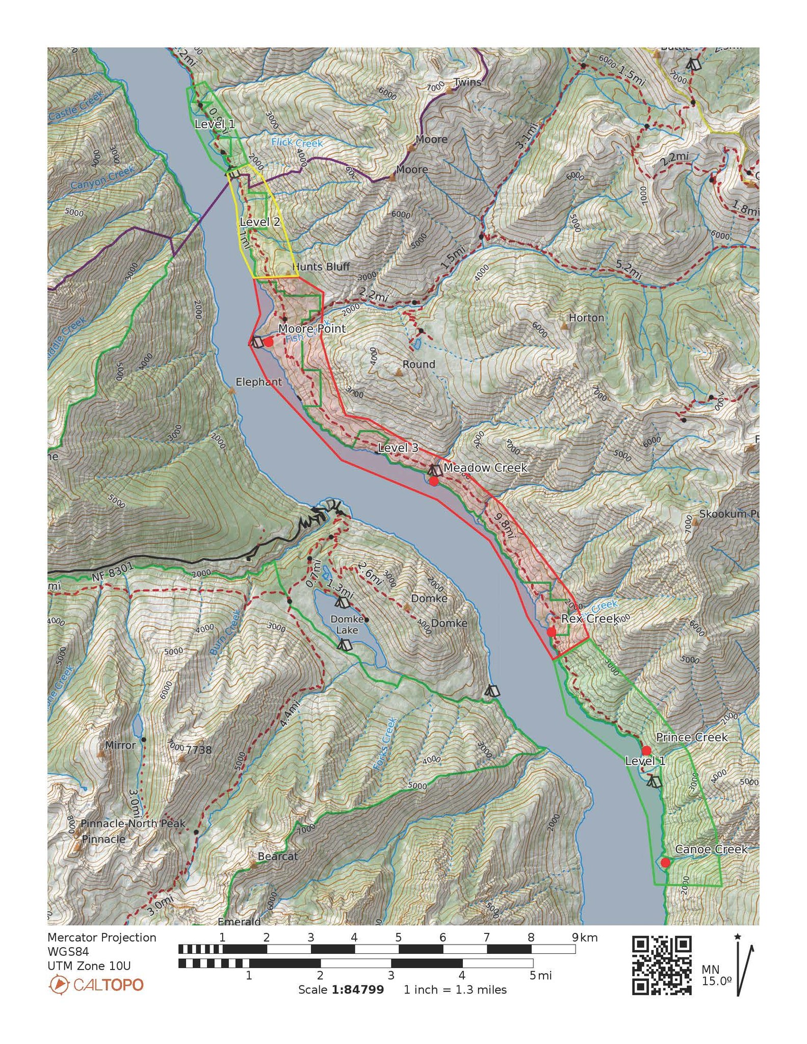
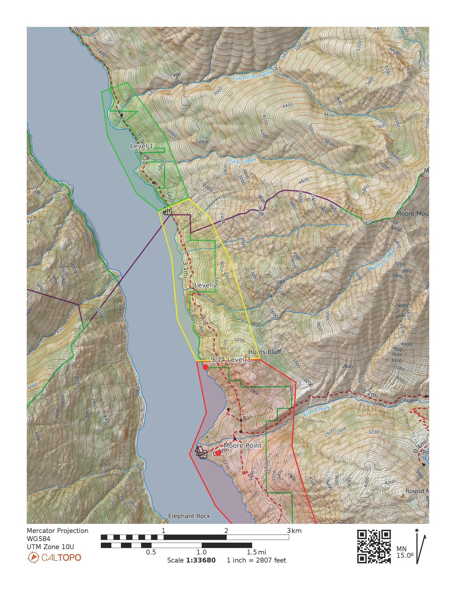
Evacuations: A Level 3 (Go Now) evacuation order is in place for the area around Rex Creek and extends up lake to Hunts Bluff, including the Moore Point area and campground. A Level 2 (Be Prepared) evacuation order is in place for Hunts Bluff up lake to the Flick Creek campground. Level 1 (Be Aware) evacuation orders are in place from Flick Creek Campground to Flick Creek proper. Down lake, Level 1 evacuation orders are in place from the Rex Creek evacuation area to Canoe Creek. Please visit https://www.co.chelan.wa.us/emergency-management/pages/active-emergencies for the most current information on evacuations.
Closures: A public safety closure order is in effect for the Lakeshore Trail from Prince Creek to up lake to the trailhead at Stehekin and portions of the Chelan Sawtooth Wilderness. Moore Point campground and the entire Lakeshore Trail are now closed. The closure includes Prince Creek, Cascade Creek, and Moore Point boat-in campgrounds. The closure order and map are posted on the Forest’s website at https://www.fs.usda.gov/detailfull/okawen/alerts-notices/?cid=fseprd521011. An interactive map of the closure area can be found at https://arcg.is/0Wbivn.
SAFETY: Recreational boaters are asked to maintain space from aircraft utilizing Lake Chelan for water collection. Recreationists are asked to follow the forest closure orders for their safety and the safety of firefighters. Closure details can be found on the link provided above in the closures section.
Public information: https://www.facebook.com/profile.php?id=61560760893080
E-mail: 2024.pioneer@firenet.gov
Phone: 509-210-2926 8 a.m.-5 p.m. (7 days a week)
Washington Smoke Blog: https://wasmoke.blogspot.com/
Pioneer Fire evacuation levels changing 06 14 2024
Related Incident:
Publication Type: Announcement
From Chelan County Emergency Management:
PIONEER FIRE EVACUATION LEVEL UPDATES: Evacuation levels are expanded on the Pioneer Fire, which is burning on the north shore of upper Lake Chelan. Below we have attached a map of the evacuation levels as well as a close-up map of those evacuation levels up river.
Level 3: Rex Creek to just north of Moore Point, Level 3, in red, means leave the area immediately, or stay out of this area.
Level 2: Just North of Moore Point to and including Flick Creek Campground. Level 2, in yellow, means prepare yourself so you are able to leave the area immediately.
Level 1 (up lake): Flick Creek Campground to and including the Fourmile Creek camping area. Level 1, in green, means closely monitor the wildfire activity in your area.
Level 1 (down lake): Rex Creek to and including Canoe Creek.
The Chelan County Emergency Incidents Map is being updated. Monitor the map at https://chelangis.maps.arcgis.com/.../media/index.html...
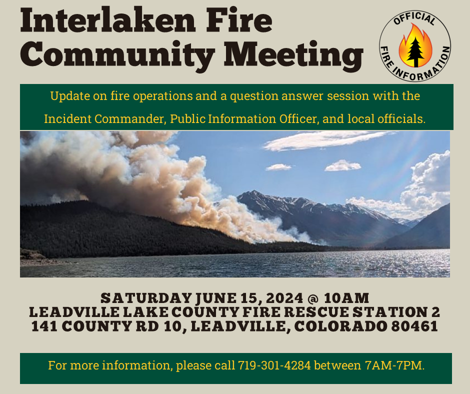
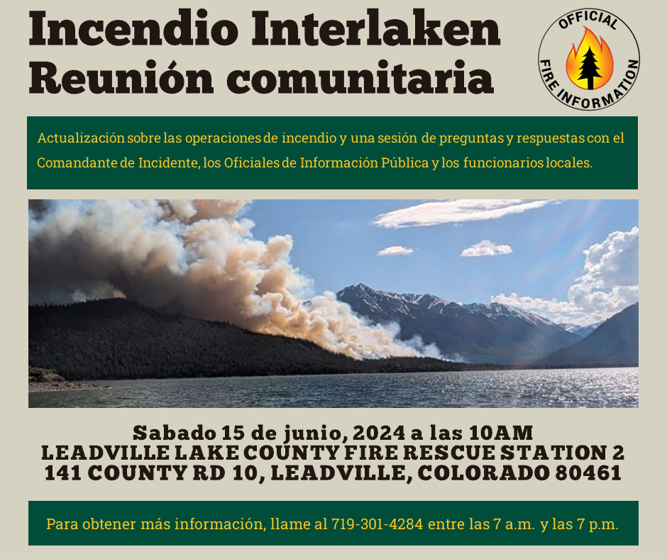
Interlaken Fire Community Meeting June 15 2024 10AM 06 14 2024
Related Incident: Interlaken Fire
Publication Type: Announcement
Come join us for an Interlaken Fire Community Meeting on June 15, 2024, at 10:00 AM. Meeting will be located at the Leadville Lake County Fire Rescue Station 2, 141 County Road 10, Leadville, Colorado.
Update on fire operations and a question answer session with the Incident Commander, Public Information Officer, and local officials. Meeting video will be posted on Interlaken Fire Facebook page. A Spanish speaking interpreter will be at the meeting.
Facebook: https://www.facebook.com/profile.php?id=61560818226034 (“Interlaken Fire Information”)
For more information, please call 719-301-4284 between 7AM-7PM
ANUNCIO ESPECIAL: Habrá una REUNIÓN DE LA COMUNIDAD sobre el incendio de Interlaken el sábado 15 de junio a las 10 a.m. en la Estación de Bomberos del Condado de Leadville Lake, 141 CR 10. Video subido después. Interpretación en español disponible.
Post Fire Recovery Helpful Links for Blue 2 Fire 06 14 2024
Related Incident: Blue 2 Fire Post-Fire BAER
Publication Type: Announcement
Recovery after wildfires is a cooperative effort by many cooperating government entities. The QR code below contains helpful links of the parties involved in Post-Wildfire Recovery and where you can find more information.
- Inciweb Blue 2 Post Fire BAER information
- Lincoln National Forest
- City of Alamogordo for status on Bonito Lake Reservoir
- Lincoln County Post-Fire Recovery
- New Mexico Department of Homeland Security and Emergency Management
- Natural Resource Conservation District Emergency Watershed Protection Program
- National Weather Service-flood alerts and warning on Burn Scar Matrix link
- Upper Hondo Soil and Water Conservation District for technical assistance
- New Mexico Division of Forestry for Seedling Reforestation
- New Mexico Division of Forestry for Fire Prevention
- Village of Ruidoso Emergency Management