
Spanish USFS Pike and San Isabel NF Leadville Ranger District Closure Order June 18 2024 06 19 2024
Related Incident: Interlaken Fire
Publication Type: Closures
U.S. Department of Agriculture, U.S. Forest Service Pike and San Isabel National Forests and Cimarron and Comanche National Grasslands Leadville Ranger District
Cierres de áreas, senderos y carreteras
Order Number: # 02-12-01-24-16
PROHIBICIONES
De conformidad con 16 U.S.C. § 551 y 36 C.F.R. § 261.50 (a) y (b), lo siguiente está prohibido en las tierras, caminos y senderos del Sistema Forestal Nacional (NFS) en el Distrito de Guardabosques de Leadville, el Bosques Nacional de Pike-San Isabel y los Pastizales Nacionales Cimarrón y Comanche, descritos a continuación y mostrados en el mapa adjunto incorporado a esta orden como Anexo A (el "Área Descrita, Caminos y senderos"):
1. Entrar o estar en el área descrita. 36 C.F.R. §§ 261.52(e), 261.53(e)
2. Estar en los senderos descritos. 36 C.F.R § 261.55(a)
EXENCIONES
De conformidad con 36 C.F.R. § 261.50(e), las siguientes personas están exentas de esta Orden:
1. Los propietarios privados pueden acceder a las carreteras 399 y 398 de NFS para acceder a sus propiedades ubicadas fuera de estas carreteras de NFS, a menos que el Servicio Forestal y el Departamento del Sheriff del Condado de Lake implementen un aviso de evacuación.
2. Las personas con Permiso del Servicio Forestal No. FS-7700-48 (Permiso para el Uso de Caminos, Senderos o Áreas Restringidas por Regulación u Orden), eximiéndolos específicamente de esta Orden o de una determinación por escrito de un funcionario autorizado del Servicio Forestal de que no se requiere un permiso bajo 36 C.F.R. § 251.50(e)(1) o (2).
3. Cualquier oficial federal, estatal o local, o miembro de una fuerza organizada de rescate o extinción de incendios en el desempeño de un deber oficial.
DESCRITO: ÁREA/CAMINOS Y SENDEROS
El Área Descrita son todas las tierras de NFS dentro de los siguientes límites: El Área Descrita cubre Twin Lakes y las áreas de uso durante todo el día que se muestran en el Anexo A, incluyendo Big Mac, Dexter Point y Sunnyside, Cabin Cove, Whistler Point y Mountain View, estos sitios están todos en el lado norte de Twin Lakes y el campamento Dexter, el campamento en el lado norte de Twin Lakes. Las áreas de campamento dispersas debajo de la presa Twin Lakes también se encuentran en el área descrita. Las Carreteras Descritas son
Order Number: # 02-12-01-24-16
todas las Carreteras NFS (NFSR) ubicadas en el Área Descrita, incluyendo NFSR #399, #399A y #399B; NFSR #398 y #398A; NFSR #179, NFSR #170A y NFSR #174A y NFSR #175, #175A, #175B y #175C.
Los Senderos Descritos son Senderos NFS (NFST) ubicados en y bordeando el Área Descrita, incluyendo NFST #1776, segmento 11 del sendero Colorado entre el sendero Interlaken y Clear Creek.
PROPÓSITO
El propósito de esta Orden es proteger la seguridad pública.
IMPLEMENTACIÓN
1. Esta Orden estará vigente desde el 18 de junio de 2024 a las 3:00 p. m. hasta el 15 de julio de 2024 a las 11:59 p. m., a menos que se rescinda.
2. Se adjunta un mapa que identifica el área, los caminos y los senderos descritos anteriormente y forma parte de esta Orden como Anexo A, ir a https://www.fs.usda.gov/alerts/psicc/alerts-avisos
3. A menos que se defina expresamente lo contrario en esta Orden, los términos utilizados en esta Orden están definidos por las regulaciones del Secretario de Agricultura, 36 C.F.R. Capítulo II, Partes 200-299. Si hay términos en esta Orden que no están expresamente definidos en la Orden o en el Título 36 del C.F.R., Capítulo II, Partes 200-299, su significado se determinará mediante sus definiciones en lenguaje sencillo.
4. Una violación de las prohibiciones anteriores se castiga como un delito menor de Clase B con una multa de no más de $5,000 para individuos y $10,000 para organizaciones, o con prisión por no más de seis meses, o ambos. 16 U.S.C. § 551; 18 del Código de los Estados Unidos.
§§ 3559, 3571 y 3581.
5. Para obtener más información sobre esta Orden, comuníquese con el Distrito de Guardabosques de Leadville en Leadville, Colorado, (719) 486-0749, y con la Oficina del Supervisor del Supervisor Forestal Nacional de los Bosques Nacionales de Pike y San Isabel y la Oficina del Supervisor Forestal Nacional de los Pastizales Nacionales Cimarrón y Comanche en Pueblo, Colorado, (719) 553-1400.
6. Esta Orden reemplaza cualquier Orden anterior que prohíba los mismos actos o actos similares en o sobre la misma Área Descrita, Caminos y Senderos.
Firmado y emitido el 18 de junio de 2024
Ryan Nehl
Supervisor de Bosques y Pastizales, Bosques Nacional Pike-San Isabel y
Pastizales Nacionales Cimarrón y Comanche
USFS Pike and San Isabel NF Leadville Ranger District Closure Order Revised June 18 2024 06 18 2024
Related Incident: Interlaken Fire
Publication Type: Closures
U.S. Department of Agriculture, U.S. Forest Service
Pike and San Isabel National Forests and Cimarron and
Comanche National Grasslands
Leadville Ranger District
Area, Trail, and Road Closure
Order Number: # 02-12-01-24-16
PROHIBITIONS
Pursuant to 16 U.S.C. § 551 and 36 C.F.R. § 261.50 (a) and (b), the following are
prohibited on the National Forest System (NFS) lands, roads, and trails in the Leadville
Ranger District, Pike-San Isabel National Forests & Cimarron and Comanche National
Grasslands, described below and shown on the attached map incorporated into this order
as Exhibit A (the “Described Area, Roads, and Trails”):
1. Going into or being in Described Area. 36 C.F.R. §§ 261.52(e), 261.53(e)
2. Being on the Described Trails. 36 C.F.R § 261.55(a)
EXEMPTIONS
Pursuant to 36 C.F.R. § 261.50(e), the following persons are exempt from this Order:
1. Private Landowners may access NFS Roads 399 and 398 to access their
properties located off these NFS Roads unless an evacuation notice is
implemented by Forest Service and Lake County Sheriff’s Department.
2. Persons with Forest Service Permit No. FS-7700-48 (Permit for Use of Roads,
Trails, or Areas Restricted by Regulation or Order), specifically exempting them
from this Order or a written determination by a Forest Service authorized officer
that a permit is not required under 36 C.F.R. § 251.50(e)(1) or (2).
3. Any Federal, State, or Local Officer, or member of an organized rescue or
firefighting force in the performance of an official duty.
DESCRIBED: AREA/ROADS AND TRAILS
The Described Area is all NFS lands withing the following boundaries: The Described
Area covers Twin Lakes and all-day use areas shown in Exhibit A, including Big Mac,
Dexter Point and Sunnyside, Cabin Cove, Whistler Point and Mountain View, these sites
are all on the northside of Twin Lakes and Dexter Campground, the campground on the
northside of Twin Lakes. The dispersed camping areas below Twin Lakes Dam are also
Order Number: # 02-12-01-24-16
located in the Described Area. The Described Roads are all NFS Roads (NFSR) located
in the Described Area, including NFSR #399, #399A and #399B; NFSR #398 and #398A;
NFSR #179, NFSR #170A, and NFSR #174A and NFSR #175, #175A, #175B and #175C.
The Described Trails are NFS Trails (NFST) located in and bordering the Described Area,
including NFST #1776, Segment 11 of the Colorado Trail between Interlaken Trailhead
and Clear Creek.
PURPOSE
The purpose of this Order is to protect public safety.
IMPLEMENTATION
1. This Order shall be in effect from June 18, 2024 at 3:00 PM through July 15, 2024
at 11:59 PM, unless rescinded.
2. A map identifying the Described [Area/Roads/Trails] is attached and made part of
this Order as Exhibit A, go to https://www.fs.usda.gov/alerts/psicc/alerts-notices.
3. Unless otherwise expressly defined in this Order, the terms used in this Order are
defined by the regulations of the Secretary of Agriculture, 36 C.F.R. Chapter II,
Parts 200-299. If there are terms in this Order that are not expressly defined in the
Order or 36 C.F.R. Chapter II, Parts 200-299, their meaning shall be determined
by their plain language definitions.
4. A violation of the above prohibitions is punishable as a Class B misdemeanor by
a fine of not more than $5,000 for individuals and $10,000 for organizations, or by
imprisonment for not more than six months, or both. 16 U.S.C. § 551; 18 U.S.C.
§§ 3559, 3571, and 3581.
5. Contact the Leadville Ranger District in Leadville, Colorado, (719) 486-0749, and
Pike and San Isabel National Forests and Cimarron and Comanche National
Grasslands National Forest Supervisor’s Office in Pueblo, Colorado, (719) 553-
1400, for more information about this Order.
6. This Order supersedes any previous Orders prohibiting the same or similar acts in
or on the same Described Area, Roads and Trails.
Signed and issued on _________.
_______________________
Ryan Nehl
Forest and Grasslands Supervisor
Pike-San Isabel National Forests &
Cimarron and Comanche National Grasslands
Safety Closure Due to Wildland Fire Encerrita Fire 06 18 2024
Related Incident: Encerrita Fire
Publication Type: Closures
The Encerrita Fire was discovered on June 15, 2024, on El Malpais National Monument lands. To maintain the safety of park visitors and allow fire management operations to continue unimpeded, the Superintendent of El Malpais National Monument is designating the following area(s) as closed to public use until further notice is given.
By order of the Superintendent of El Malpais National Monument and under authority of Title 36, Code of Federal Regulations, Section l.5 (a) and Section (a)(l):
- Continental Divide Trail between Porter Ranch Road and Highway 117
- Zuni-Acoma Trail
- Zuni-Acoma Trail parking lot (Hwy 53)
- Acoma-Zuni Trail parking lot (Hwy 117)
- Fire Operational Area
The area will be closed until further notice is given. Notice of closure will be posted and the area will be monitored to ensure compliance. This order supersedes and includes all prior area closures. The designation will remain in place until rescinded.
Tuesday Encerrita Fire Update 06 18 2024
Related Incident: Encerrita Fire
Publication Type: News
Encerrita Fire Update
June 18, 3 p.m.
Additional crews arrived on Monday and Tuesday morning to assist local firefighters working on the Encerrita Fire currently burning on El Malpais National Monument. The lightning-caused fire was discovered on June 15 and is estimated to be approximately 1,300 acres as of Tuesday morning. The fire remains on NPS lands and does not pose an imminent threat to local communities.
On Monday, the fire was active on the north and northwest sides, fueled by high temperatures, low humidity, and steady winds. Ground crews began establishing an anchor point on the remote south side of the fire. Ground resources were assisted by aircraft on Monday, including 4 retardant drops along the north side of the fire.
On Tuesday, crews will complete the anchor point and begin constructing line along the west side of the fire to connect with the Continental Divide Trail. Firefighters will improve and secure retardant lines to reduce the likelihood of the fire moving onto neighboring jurisdictions. Weather is expected to remain hot and dry until a frontal passage late Wednesday, which will bring higher humidity, southeast winds, and a chance of precipitation later in the week.
Additional fire management staff arrived at the incident on Monday and Tuesday morning to support the growing number of firefighters committed to the fire. The incident will transition to a Type 3 organization on Thursday, under the command of Incident Commander Mike Wallace.
Closures remain in effect in the monument. The Continental Divide Trail and Zuni-Acoma Trail are closed in El Malpais National Monument from Porter Ranch Rd off Hwy 53 to Hwy 117; a CDT bypass is in place between CDT miles 502.5 to 512.5; more information is available on the CDT website. In addition to the western Zuni-Acoma Trail parking lot closure, the closure order was expanded on Tuesday to include the eastern Acoma-Zuni parking lot. Closures have been posted and the public is asked to avoid closed roads, trails, and parking lots. The El Calderon Trail remains open.
An Inciweb page has been established for the Encerrita Fire. Fire updates will continue to be posted to the El Malpais National Monument Facebook page (@ElMalpaisNPS) and to Inciweb.
Inciweb: https://inciweb.wildfire.gov/inciden.../nmemp-encerrita-fire.
Park closures: https://www.nps.gov/.../superintendent-s-compendium.htm.
CDT Info: https://continentaldividetrail.org/closures-and-notices/.
CANCELLED Multiagency prescribed burn at Red Bluff Recreation Area 06 18 2024
Related Incident: Mendocino NF Fall 2023/Spring 2024 RX Fire Projects
Publication Type: News
Mendocino National Forest’s fire personnel have cancelled the interagency prescribed burn at the Red Bluff Recreation Area planned for this week due to resource availability. After increased fire activity during red flag weather conditions, fire resources are committed to supporting suppression efforts in the region.
Actualizacin del incendio Interlaken 18 de junio 2024 a las 800 am 06 18 2024
Related Incident: Interlaken Fire
Publication Type: News
Actualización del incendio Interlaken
18 de junio, 2024 a las 8:00 a.m.
Equipo de Gestión de Incidentes Tipo 3
Nick Ostrom, Comandante de Incidente
Ubicación: 7 millas S-SW de Leadville, Colorado
Fecha de reporte: 11 de junio de 2024 a las 2:01 pm
Causa: Causada por humanos Tamaño: 739 acres Contención: 86% Personal total: 297
Situación Actual: Como recordatorio, todas las carreteras, pueblos y la mayoría de los negocios cerca del área del incendio están abiertos al público. Por seguridad pública, se ha establecido un cierre en ciertos senderos y caminos en el área del incendio (consulte la sección de cierre a continuación) para permitir que los bomberos supriman el fuego y eliminen los árboles de peligro cerca de los senderos y caminos. Ayer fue otro día exitoso en la línea de fuego. El comportamiento del fuego es mínimo a lo largo del perímetro del incendio en las porciones este, oeste y sur del incendio. Partes del interior tienen un comportamiento moderado del fuego a medida que el fuego se arrastra a lo largo del suelo del bosque y arde en altos concentrados de vegetación terrestre y hojarasca de agujas de pino. Se ha observado quema ocasional de un solo árbol en el perímetro norte (DIV A) cuando persisten condiciones más cálidas y ventosas. El fuego continúa retrocediendo cuesta abajo hacia la orilla del lago, produciendo humo constante en esa área. Un módulo de bomberos permanece trabajando cerca de las estructuras históricas para enfriar los focos de vegetación en llamas dentro del perímetro del incendio. Los bomberos continúan asegurando el extremo sur (DIV D) del incendio enfriando las áreas de calor con agua y herramientas manuales para aumentar la profundidad de contención desde el perímetro.
Hoy, los bomberos continuarán asegurando la línea de fuego localizando focos de calor y usando herramientas manuales y agua para enfriar las áreas calientes y expandir la profundidad de las líneas de contención. Las operaciones de motosierra continuarán eliminando árboles peligrosos a lo largo de los senderos y el sistema de 399 carreteras para que el área sea segura para uso recreativo futuro. Los aviones se están utilizando para apoyar a los bomberos en tierra con el transporte de agua, carga y para operaciones de reconocimiento. El sistema de aeronaves no tripuladas (UAS) (drones) se utilizará para el reconocimiento y los datos infrarrojos. Estos drones están asignados al incendio y son operados por bomberos pilotos certificados. Hay una Restricción Temporal de Vuelo (TFR) sobre el área del incendio. Si tú VUELAS, nosotros NO PODEMOS. No vuele ni opere sus propios drones en esta área, ya que obstaculizará los esfuerzos de extinción de incendios y dejará en tierra nuestras aeronaves.
Es posible que haya una reducción en los recursos de incendios a medida que disminuye la amenaza de incendios en Interlaken, lo que permite que los recursos ayuden con los incendios forestales en otras partes de los EE. UU.
Humo: La calidad del aire en las áreas circundantes y en el corredor de la autopista 82 ha mejorado con un comportamiento de fuego de bajo a moderado. Los monitores de calidad del aire informan de verde en la escala de índice durante el día y moderado durante las horas de la tarde y la madrugada (https://www.colorado.gov/airquality/colo_smoke.aspx). Visite https://www.airnow.gov/wildfires/ para obtener recursos sobre el humo.
Clima: Continúan las condiciones secas y ventosas. Soleado hoy, temperaturas máximas de 68F con humedad del 13 al 18%. Los vientos volverán a aumentar por la tarde a 14 mph del suroeste.
Cierres: Tenga en cuenta que hay varios cierres de senderos, lotes y carreteras. A partir del 6-14-24, hay una orden oficial del Servicio Forestal. Consulte el sitio web del PSICC y consulte la sección RESTRICCIONES DE INCENDIOS Y ÓRDENES FORESTALES en la página principal. Vea el mapa de cierre aquí: https://www.fs.usda.gov/Internet/FSE_DOCUMENTS/fseprd1181393.pdf, y la orden de cierre aquí: https://www.fs.usda.gov/Internet/FSE_DOCUMENTS/fseprd1181392.pdf
Evacuaciones: Todos los avisos previos a la evacuación se levantaron el 16 de junio de 2024 a las 7 p.m. Para inscribirse para recibir alertas de emergencia en el condado de Lake, visite: https://member.everbridge.net/892807736726383/login y en el condado de Chaffee, https://member.everbridge.net/892807736725694/login.
INFORMACIÓN sobre el Incendio Interlaken:
Línea telefónica de información: 719-301-4284 (hora: 7 a.m. a 7 p.m.)
Correo electrónico:2024.interlaken@firenet.gov
Facebook: https://www.facebook.com/profile.php?id=61560818226034
InciWeb: https://inciweb.wildfire.gov/incident-information/copsf-interlaken-fire
Spanish Language Pioneer Fire update 06 18 2024
Related Incident:
Publication Type: News
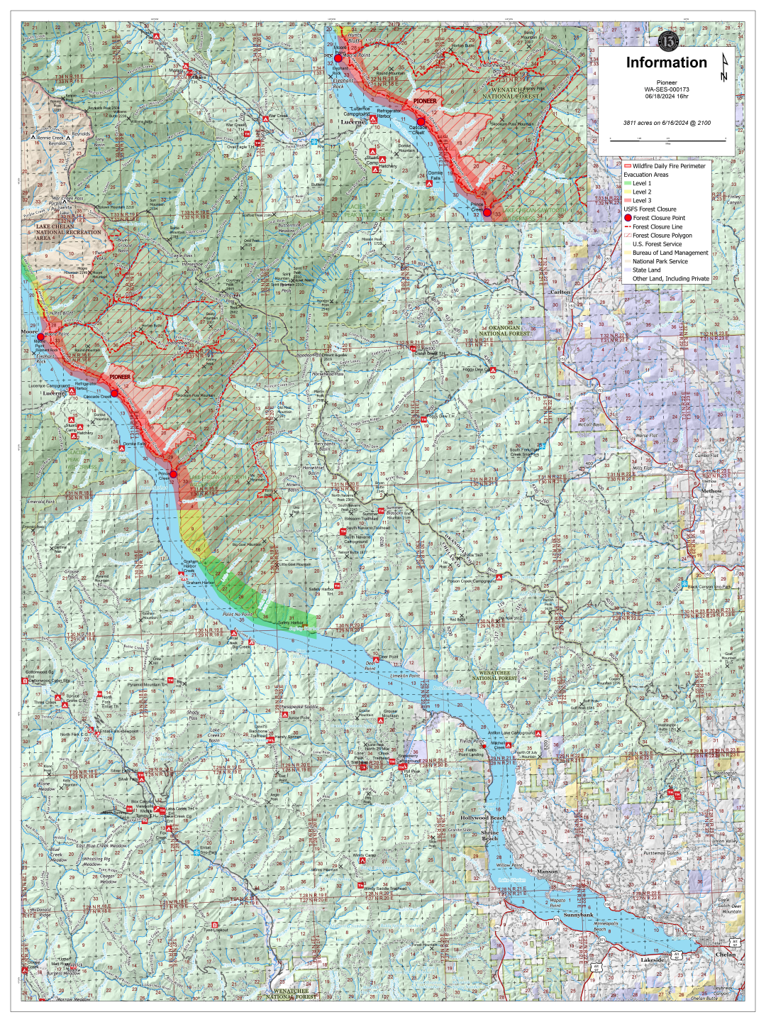
Incendio Pioneer Actualizado para el Martes, 18 de Junio, 2024
CHELAN, Wash. — El incendio Pioneer está ardiendo en el área silvestre del lago Chelan-Sawtooth en el distrito de guardabosques de Chelan del Bosque Nacional Okanogan-Wenatchee y en tierra privada.
Ayer la actividad del fuego permaneció moderada, el incendio está siendo detenido entre Meadow Creek y Prince Creek. Los combustibles verdes y el viento del noroeste continúan deteniendo la progresión del incendio hacia norte
Los combatientes de incendio han terminado el trabajo de preparación para proteger las estructuras contra el fuego en Meadow Creek y continúan trabajando en Moore Point.
Se está planificando establecer un acampamento remoto /coyote en Stehekin, cual posicionara recursos para apoyar las actividades al norte.
Hacia el sur, el fuego esta retrocediendo hacia abajo del pendiente en Prince Creek, con la potencial de fuegos secundarios a través del drenaje donde la pendiente del cerro se inclina hacia el lago. El trabajo de protección para proteger las estructuras alrededor de Canoe Creek deben ser terminadas hoy.
Debido al terreno escabroso y la falta de infraestructuras en la área silvestre, es probable que el incendio continue ardiendo durante algún tiempo. El personal de incendio están desarrollando estrategias de supresión de largo-plazo para el potencial uso este verano.
Está pendiente del cierre oficial de la carretera Grade Creek (8200). Los portones estarán cerrados en Mitchell Creek, el crucero de los caminos 8200 y 8020, cerca de Gold Creek Road, y el crucero de los caminos 117 y 8020 cerca de Oss Peak. Esto permitirá que las operaciones de equipos pesados trabajen sin interrupción para mejorar el camino y crear una ruta segura para que los vehículos y equipos de combatientes de incendio se aproximen al incendio desde el sureste. Se espera que estos trabajos duren como ocho días.
Los equipos pesados también están trabajando para retirar la nieve y reabrir una antigua línea de dozer a lo largo de la cima de Coyote Ridge hacia el oeste desde Summer Blossom, mientras que las brigadas manuales construyen línea de fuego hasta la orilla del lago Chelan.
Los recursos aéreos volaron 18 horas y media el domingo, transportando 103.000 galones de agua y 15.000 libras de carga, además de realizar vuelos de reconocimiento y descargas de agua a lo largo de los flancos norte y sur.
Las temperaturas subirán gradualmente hasta el final de la semana, con máximas que alcanzarán los 80 grados. Mañana, los vientos cambiarán del noroeste al sureste, lo que puede afectar al comportamiento del fuego.
Humo Y Calidad del Aire: Verifique las condiciones actuales de la calidad del aire en https://bit.ly/PioneerFireSmoke. Obtenga más Información sobre los impactos a la salud y como prepararse para estar listo para el humo en smokeready.org.
EVACUACIONES: Una orden de evacuación de Nivel 3 (Vallase Ya) está vigente desde casi el norte de Moore Point hasta el sur de Canoe Creek: Cuesta abajo del lago: Se ha emitido una orden de evacuación de nivel 2 (Esté preparado) desde abajo del lago de Canoe Creek hasta Lone Fir Creek. Una orden de Nivel 1 (Mantenerse en alerta) está vigente desde Lone Fir Creek hacia abajo del lago hasta Safety Harbor. Cuesta arriba del lago: Una orden de evacuación de Nivel 2 (Esté preparado) está vigente desde el norte de Moore Point hasta, e incluyendo, el campamento Flick Creek. Una orden de evacuación de Nivel 1 (Mantenerse en alerta) está vigente cuesta arriba del lago desde el campamento Flick Creek hasta, e incluyendo, el área de campamento de Fourmile Creek. Por favor visite County of Chelan, Washington para obtener la información más actualizada sobre evacuaciones.
Cierres: Una orden de cierre de seguridad pública está vigente para el sendero de Lakeshore Trailhead desde Prince Creek hacia arriba del lago hacia Lakeshore Trailhead en Stehekin y porciones del área silvestre de Chelan Sawtooth Wilderness. El acampamento Moore Point y todo el sendero Lakeshore Trail estan cerrados. El cierre incluye Prince Creek, Cascade Creek, y Moore Point, y Flick Creek (NPS) el acampamento botes/barcos. Un mapa interactivo del área de cierre del Servicio Forestal se puede encontrar en: https://arcg.is/0Wbivn. Está pendiente el cierre del camino Grade Creek (8200) debido a las operaciones de equipo pesado.
SEGURIDAD: Se les pide a los navegantes recreativos que mantengan el espacio de las aeronaves que utilizan el lago Chelan para la recolección de agua. Se pide a los recreacionistas que sigan las órdenes de cierre de bosques por su seguridad y la seguridad de los combatientes de incendios.
Para recibir actualizaciones por correo electrónico, regístrese en https://lp.constantcontactpages.com/sl/PndMhvq
Pioneer Fire update 06 18 2024
Related Incident:
Publication Type: News
Pioneer Fire Update for Tuesday, June 18, 2024
CHELAN, Wash. — The Pioneer Fire is burning in the Lake Chelan-Sawtooth Wilderness Area in the Chelan Ranger District of the Okanogan-Wenatchee National Forest and on private land.
Fire activity remained moderate yesterday, and the fire is holding between Meadow Creek and Prince Creek. Green fuels and the northwesterly wind continued to slow northward progression of the fire.
Firefighters have completed structure protection prep work at Meadow Creek and continue to work at Moore Point.
Planning is underway to establish a spike camp at Stehekin, which will position resources to support activities to the north.
To the south, the fire is backing downslope into Prince Creek, with potential for spotting across the drainage where the ridge slopes down to the lakeshore. Structure protection prep work around Canoe Creek should be completed today.
Due to the rugged terrain and lack of infrastructure within the wilderness, the fire is likely to continue burning for some time. Fire personnel are developing long-term suppression strategies for potential use later this summer.
An official closure of the Grade Creek (8200) Road is pending. Gates will be closed at Mitchell Creek, the junction of 8200 and 8020 roads near Gold Creek Road, and the junction of 117 and 8020 roads near Oss Peak. This will allow heavy equipment operations to work without disruption to improve the road and create a safe route for fire vehicles and equipment to approach the fire from the southeast. This work is expected to take about eight days.
Heavy equipment is also working to remove snow and reopen an old dozer line along the top of Coyote Ridge westward from Summer Blossom while hand crews build line down to the Lake Chelan shoreline.
Aviation resources logged 18.5 flight hours Sunday, transporting 103,000 gallons of water and 15,000 pounds of cargo in addition to reconnaissance flights and water drops along the north and south flanks.
Temperatures will climb gradually through the end of the week, with highs reaching into the 80s. Tomorrow, winds will shift from the northwest to southeast, which may affect fire behavior.
A public meeting will be held at 5 p.m. Tuesday, June 18, at the North Cascades National Park Golden West Visitor Center in Stehekin, Wash. This meeting will not have a virtual option.
Smoke & Air Quality: Moderate smoke conditions are possible in Chelan, Manson, and Methow by the late afternoon with improvement overnight. Stehekin, Winthrop, and Twisp should see generally good air quality with most smoke staying to the south of those locations. Check current air quality conditions at https://bit.ly/PioneerFireSmoke.
EVACUATIONS: A Level 3 (Go Now) evacuation order is in place from just north of Moore Point south to Canoe Creek. Down lake: A Level 2 (Be Prepared) evacuation order has been issued down lake from Canoe Creek to Lone Fir Creek. A Level 1 (Stay Alert) order is in place from Lone Fir Creek down lake to Safety Harbor. Up lake: A Level 2 (Be Prepared) evacuation order is in place from just north of Moore Point to, and including, Flick Creek Campground. A Level 1 (Stay Alert) evacuation order is in place up lake from Flick Creek Campground to, and including, the Fourmile Creek camping area. Please visit County of Chelan, Washington for the most current information on evacuations.
Closures: A public safety closure order is in effect for the Lakeshore Trail from Prince Creek up lake to the Lakeshore Trailhead at Stehekin and portions of the Chelan Sawtooth Wilderness. Moore Point campground and the entire Lakeshore Trail are now closed. The closure includes Prince Creek, Cascade Creek, Moore Point, and Flick Creek (NPS) boat-in campgrounds. An interactive map of the Forest Service closure area can be found at https://arcg.is/0Wbivn.
Interlaken Fire Update 06 18 2024
Related Incident: Interlaken Fire
Publication Type: News
Type 3 Incident Management Team,
Nick Ostrom, Incident Commander
Location: 7 miles S-SW of Leadville, Colorado
Date Reported: June 11, 2024, at 2:01pm
Cause: Human caused
Size: 739 acres
Containment: 86%
Total Personnel: 237
Current Situation: As a reminder all highways, towns, and a majority of businesses near the fire area are open for business. For public safety, a closure is in place on certain trails and roads in the fire area (see closure section below) to allow firefighters to suppress the fire and remove hazard trees near trails and roads. Yesterday was another successful day on the fireline. Fire behavior is minimal along the fire perimeter on the east, west, and south portions of the fire. Portions of the interior have moderate fire behavior as fire creeps along the forest floor and smolders in high concentrates of ground vegetation and pine needle litter. Occasional single tree torching has been observed on the northern perimeter (DIV A) when hotter and windy conditions persist. Fire continues to back downhill towards the lake shore producing consistent smoke in that area. A fire module remains working near the historical structures to cool pockets of burning vegetation within the fire perimeter. Firefighters continue to secure the south end (DIV D) of the fire by cooling areas of heat with water and hand tools to increase the containment depth from the perimeter.
Today, firefighters will continue to secure the fireline by locating pockets of heat and using hand tools and water to cool hot areas and expand depth of containment lines. Chainsaw operations will continue to remove hazardous trees along trails and the 399-road system to make the area safe for future recreational use. Aircraft are being utilized to support firefighters on the ground with transporting water, cargo, and for recon operations. Unmanned Aircraft System (UAS) (drones) will be used for reconnaissance and infra-red data. These drones are assigned to the fire and operated by certified pilot firefighters. There is a Temporary Flight Restriction (TFR) over the fire area. If you FLY, we CAN’T. Do not fly or operate your own drones in this area, as it will impede firefighting efforts and ground our aircraft.
There may be a reduction in fire resources as the Interlaken fire threat diminishes allowing resources to assist with wildfires in other part of the U.S.
Smoke: Air quality in surrounding areas and the Hwy 82 corridor has improved with low to moderate fire behavior. Air quality monitors are reporting green on the index scale during the day and moderate during evening/early morning hours. https://www.colorado.gov/airquality/colo_smoke.aspx) Visit https://www.airnow.gov/wildfires/ for resources on smoke.
Weather: Dry and windy conditions continue. Sunny today, max temps 68F with humidity 13-18%. Winds will pick up again in the afternoon 14 mph from the southwest.
Closures: Be aware that several trail, lot, and road closures are in place. As of 6-14-24, there is an official order from the Forest Service. Refer to the PSICC website and check under FIRE RESTRICTIONS AND FOREST ORDERS on the main page. See closure map here: https://www.fs.usda.gov/Internet/FSE_DOCUMENTS/fseprd1181393.pdf, and closure order here: https://www.fs.usda.gov/Internet/FSE_DOCUMENTS/fseprd1181392.pdf
Evacuations: All pre-evacuation notices were lifted on June 16, 2024, at 7PM. To sign up for emergency alerts in Lake County, visit: https://member.everbridge.net/892807736726383/login and in Chaffee County, https://member.everbridge.net/892807736725694/login
Interlaken Fire INFORMATION
Fire Information Phoneline: 719-301-4284 (Time: 7am-7pm) Email: 2024.interlaken@firenet.gov
Facebook: https://www.facebook.com/profile.php?id=61560818226034 (“Interlaken Fire Information”)
InciWeb: https://inciweb.wildfire.gov/incident-information/copsf-interlaken-fire
Los bomberos cambian tcticas para trabajo de reparacin de supresin en el Incendio Antone 06 17 2024
Related Incident: Antone Fire
Publication Type: News
SILVER CITY, NM, 17 de junio, 2024 – Los bomberos están enfocados en el trabajo de reparación de supresión lo cual consiste en una serie de acciones adoptadas para mitigar los impactos causados por las actividades en la extensión del incendio. Los bomberos completaron las operaciones de astillado sobre la tala a lo largo de todo el perímetro y proseguirán mitigando los arboles debilitados por el fuego a lo largo de caminos, líneas de cercas y senderos. Así mismo se continuará con el mantenimiento de caminos en la carretera del condado No. 13. El incendio Antone tiene una superficie de 12, 396 acres y se ha completado en un 60%. Por el momento hay un total de personal de 72 trabajadores apoyando el incidente.
El movimiento del fuego dependerá en la alineación del viento con el terreno y de la disponibilidad de focos de material de combustión que aún no se ha quemado. Esto puede causar fluctuaciones en la cantidad de humo visible en el área inmediata al incendio. Se prevé que el tiempo vuelva a traer condiciones secas sin humedad, humedad relativa de un solo dígito y vientos ligeros para los próximos dos días.
El Equipo Tipo 3 continúa manejando el incendio utilizando la estrategia de confinamiento y contención, que implica el uso intercambiable de tácticas de supresión directa e indirecta y de protección de puntos tácticos. Esta estrategia depende de los cambios en las condiciones. Los objetivos de la gestión incluyen la seguridad de los bomberos, la protección de los valores en riesgo, la reducción del material de combustión, el mejoramiento del hábitat y la continuación de los trabajos de restauración en la zona de Slaughter Mesa. Se proveerán comunicados de prensa cada dos días o si se da un suceso significativo en el incendio.
La Orden de Cierre No. 03-06-03-24-001 se mantendrá en efecto hasta ser revocada. Revise el mapa de la orden de cierre, marcado como Anexo A. Ambos documentos se pueden encontrar en la página web de Alertas y Cierres del Bosque Nacional de Gila en: https://www.fs.usda.gov/alerts/gila/alerts-notices
El humo puede verse desde la carretera US 60, la carretera NM 12, la comunidad de Quemado, Quemado Lake Estates, Pie Town, Datil, Horse Springs, Apache Creek y Reserve. Ver un mapa interactivo de humo en https://fire.airnow.gov/. Más información sobre el impacto del humo en https://www.env.nm.gov/air-quality/fire-smoke-links/.
Para obtener más información, póngase en contacto con Maribeth Pecotte en 575-388-8211 o Maribeth.Pecotte@usda.gov.
###
El Servicio Forestal USDA, provee igualdad de oportunidades, empleos y acreditación de tierras