
Pioneer Fire update 06 16 2024
Related Incident:
Publication Type: News
Pioneer Fire Update for Sunday, June 16, 2024
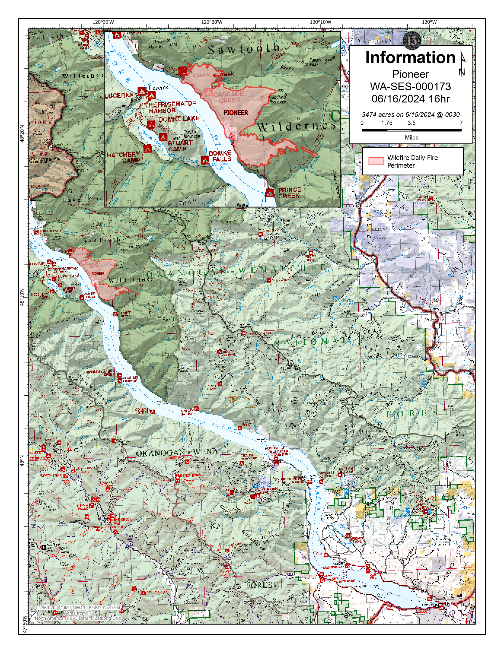
CHELAN, Wash. — The Pioneer Fire is burning in the Lake Chelan-Sawtooth Wilderness Area in the Chelan Ranger District of the Okanogan-Wenatchee National Forest and on private land.
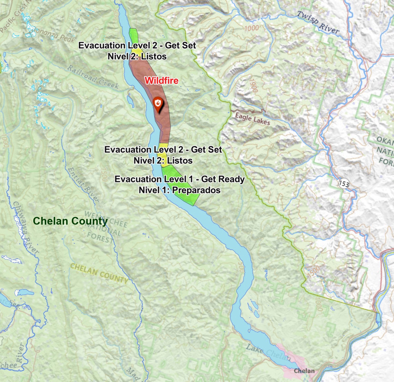
In coordination with fire managers, Chelan County Emergency Management has extended the Level 3 (Go Now) just north of Moore Point down lake to Canoe Creek. A Level 2 (Be Prepared) evacuation order has been issued down lake from Canoe Creek to Lone Fire Creek. A Level 1 (Be Aware) order is in place from Lone Fir Creek down lake to Safety Harbor. Evacuation levels up lake have not changed. Please visit County of Chelan, Washington for the most current information on evacuations.
Suppression management has been divided into two branches, Branch I, which encompasses operations and planning up lake from Point No Point on Lake Chelan to Flick Creek. Branch II is overseeing operations and planning down lake, which currently consists of road work and scouting potential control lines off upper Grade Creek road (8200).
Up lake in Branch I, the fire is now established in Meadow Creek, but fire movement is expected to be minimal near Round Lake. Today, structure protection work will continue between Meadow Creek and Moore Point with structure prep to protect private and federal infrastructure. A new structure protection division will begin assessments north of Moore Point to the North Cascades National Park boundary. The fire also progressed south through Rex Creek into Rattlesnake Creek, and potentially spotted into Prince Creek. Aviation focused efforts in Rattlesnake Creek to support ongoing infrastructure protection work in Prince Creek. Aerial resources will continue to limit fire spread as the fire progresses down lake.
Down lake in Branch II, two graders are working to improve Grade Creek Road (8200 Road) from the Cooper Ridge Road (8020 Road) across Coyote Ridge to South Navarre and Nelson Butte to provide a safe route for fire vehicles and equipment to access the south flank of Branch II. Summer Blossom is currently blocked by snowdrifts. Motorists should also be alert to water tenders traveling back and forth from Antilon Lake.
A public meeting will be held at 5 p.m. Tuesday, June 18, at the North Cascades National Park Golden West Visitor Center in Stehekin, Wash. This meeting will not have a virtual option.
Smoke & Air Quality: Saturday, strong winds blew the smoke column over Sawtooth Ridge, impacting communities from the Gold Creek area along Route 153 south to Methow and Pateros. Light smoke was also visible along Lake Chelan in the immediate vicinity of the fire. As the fire progresses, increased smoke impacts are expected along the lake. Check current air quality conditions at fire.airnow.gov. Learn more about health impacts and becoming Smoke Ready at smokeready.org.
Evacuations: Evacuation levels up lake have not changed. A Level 2 (Be Prepared) evacuation order is in place from just north of Moore Point to, and including, Flick Creek Campground. On the down lake side, a Level 2 (Be Prepared) evacuation order has been issued from Canoe Creek down lake to Lone Fir Creek. A Level 1 (Be Aware) evacuation order is in place up lake from Flick Creek Campground to, and including, the Fourmile Creek camping area.
Closures: A public safety closure order is in effect for the Lakeshore Trail from Prince Creek up lake to the trailhead at Stehekin and portions of the Chelan Sawtooth Wilderness. Moore Point campground and the entire Lakeshore Trail are now closed. The closure includes Prince Creek, Cascade Creek, and Moore Point boat-in campgrounds. An interactive map of the closure area can be found at https://arcg.is/0Wbivn. A road closure of the Grade Creek (8200) road is pending due to heavy equipment operations.
SAFETY: Recreational boaters are asked to maintain space from aircraft utilizing Lake Chelan for water collection. Recreationists are asked to follow the forest closure orders for their safety and the safety of firefighters.
To receive fire updates via email, sign up at https://lp.constantcontactpages.com/sl/PndMhvq
Public information: https://www.facebook.com/profile.php?id=61560760893080
E-mail: 2024.pioneer@firenet.gov
Phone: 509-210-2926 8 a.m.-5 p.m. daily
Washington Smoke Blog:https://wasmoke.blogspot.com/
Nisqually John Information Release 6162024 0800 06 16 2024
Related Incident: Nisqually John
Publication Type: News
FINAL Update
The Nisqually John fire has been finalized at 1,221 acres, reflecting mapping efforts by the field crews.
Today, wildland crews will continue to work towards containment goals of 100% by the end of today. With moderate temperatures and higher relative humidity, fire behavior will continue to be minimal. Small pockets of unburned fuel within the interior could ignite, leading to observable smoke for short periods of time.
Yesterday, sustained winds 20 to 30 mph, with higher gusts, possibly as high as 40-45 mph, aligning with topography and wind tested the fire line and containment. Wildland firefighting crews worked on rugged terrain to evaluate and strengthen fire line, leading to a containment of 50% by the end of shift. The state mobilization strike team provided structure protection along Steptoe Canyon Road. With reported minimal fire behavior in late afternoon, the strike team was demobilized from the fire and reassigned to fires occurring in the Yakima Valley.
Wildland crews will demobilize throughout the day, returning to local districts or reassigning to other active fires in the area.
With anticipated containment goals of 100% containment today, the Nisqually John fire will be returned to Whitman County Fire District #14 at the end of today’s shift.
We would like to thank the community of Colton, Whitman County Fire District #14, the Washington State Patrol (State Mobilization) for helping make this operation successful.
Pioneer Fire evacuation levels changed 06 15 2024
Related Incident:
Publication Type: Announcement
From Chelan County Emergency Management:
PIONEER FIRE EVACUATION LEVEL UPDATES: Evacuation levels down lake of the Pioneer Fire -- on the north shore of Lake Chelan about 31 miles from Chelan -- have changed. The Level 3 evacuation area (leave now) has been extended down lake.
The current levels are:
Level 3: Just north of Moore Point south to Canoe Creek. Level 3 (in red) means leave the area immediately.
Level 2 (down lake): Canoe Creek to Lone Fir Creek. Level 2 (in yellow) means prepare now in case you need to evaucate the area in a hurry.
Level 1 (down lake): Lone Fir Creek to Safety Harbor. Level 1 (in green) means stay alert and monitor the fire in the area.
Level 2 (up lake): Just north of Moore Point to and including Flick Creek Campground. Level 2 (in yellow) means prepare now in case you need to evaucate the area in a hurry.
Level 1 (up lake): Flick Creek Campground to and including the Fourmile Creek camping area. Level 1 (in green) means stay alert and monitor the fire in the area.
Evacuation levels are being updated on the Chelan County Emergency Incidents Map: https://chelangis.maps.arcgis.com/.../media/index.html...
Nisqually John Information Release 61524 0800 06 15 2024
Related Incident: Nisqually John
Publication Type: News
Colton, Whitman Co. - The Nisqually John was reported around 8:30am on Friday June 14th. It is located approximately 7 miles southwest of the town Colton in Whitman Co., in Whitman County Fire District #14.
Today, Scattered showers and higher relative humidities will help reduce fire behavior, however, winds are forecasted for 25 to 30 mph with gusts of 35 to 40 mph, which has the potential for another day of rapid fire spread. As of yesterday, fire progression had stopped and the fire was partially lined with fire retardant. Wildland fire crews will work towards containment of the fire and additional crews will be arriving throughout the day.
Yesterday, sustained winds 15 to 20 mph, with higher gusts, possibly as high as 30 mph, aligning with topography helped to rapidly spread the fire. Ground crews, working with aerial support, primarily helicopters and water scoopers helped to slow the spread of the fire. Several structures within Steptoe Canyon were considered threatened, along with railroad tracks and high tension (main transmission lines) power lines. Surrounding fire districts in Whitman Co., Asotin Co., Wheatland Fire District, and the cities of Moscow and Clarkston responded to the fire. Given the values at risk, State Mobilization was requested.
The Nisqually John fire is 0% contained and is estimated at 1150 acres. As crews begin to map the fire, this acreage will change. Steptoe Canyon Road and Wawawai Road along the Snake River are currently open, but wildland crews are working in the area and the public is requested to avoid the area for the safety of the crews.
Whitman County Fire District Deputy Fire Chief Nick Bell and Washington State Patrol (State Mobilization) have assigned management of the fire to Northeast Washington Interagency Type 3 Incident Management Team #2 as of 6:00am on June 15th.
The incident command post is located at the Colton High School in Colton WA. Fire information contact is Isabelle Hoygaard Reeser at 509-800-7550.
Bear Fire Update 06 16 2024
Related Incident: Bear Fire
Publication Type: News
Bear Fire
Sunday, June 16, 2024
Location of Origin: 5 miles SW of Cibecue, AZ
Start Date: June 8, 2024
Size: 447 acres
Percent Contained: 81%
Cause: Undetermined, Under Investigation
Fuels: Pinyon-Juniper, Grassland
Resources Assigned: 6 Crews, 1 Dozer, 4 Engines, 1 Helicopter, 3 Water Tenders
Fire activity has moderated, and a large portion of the fire is now contained. Transfer of command from the White Mountain Zone Type 3 Incident Management Team (IMT) to the Type 4 organization will occur at 7 a.m. on June 17, 2024. This will be the final update on the Bear Fire from the White Mountain Zone IMT.
Operations: Firefighters were able to secure lines and add containment on the northern portion of the fire yesterday. Weather is expected to remain hot and dry with no chance of precipitation and firefighters will remain vigilant. Crews will continue to work to extinguish remaining hot spots and further secure containment lines. Fire suppression rehab operations will continue in an effort to repair damages and impacts resulting from firefighting efforts.
Closures: To provide for the safety of the public and firefighters, the G-3 and G-4 roads are closed to the public.
Values at Risk: Emory Oak groves in the area, cultural sites and heritage resources, tribal sensitive species, cattle and grazing, watersheds and riparian areas, woodland areas, the Highway 60 and BIA Route 12 transportation corridors, natural springs, and Cibecue Falls.
Weather: Above normal temperatures are forecast today with a high of 93 degrees and southwest winds 10 to 15 mph.
Smoke: Wildfire smoke may impact Cibecue, Carrizo, and the White Mountain communities. Go to fire.airnow.gov/ to see the latest smoke conditions in your community. Smoke may be visible from the surrounding communities.
Evacuations: There are no evacuations currently. Residents of Cibecue are in “READY” status. The public is encouraged to prepare and follow the Ready, Set, Go! program to prepare for any threats to their community. Go to https://311info.net/ for accurate and timely status updates.
Official fire information can be found on these sites:
• Inciweb: https://inciweb.wildfire.gov/incident-information/azfta-bear-fire
• Facebook: https://www.facebook.com/BIAFAAFireMgt
Actualizacin del incendio de Interlaken 16 de junio 2024 a las 800 am 06 16 2024
Related Incident: Interlaken Fire
Publication Type: News
Actualización del incendio de Interlaken
16 de junio, 2024 a las 8:00 a.m.
Equipo de Gestión de Incidentes Tipo 3
John Markalunas, Comandante de Incidente
Ubicación: 7 millas S-SW de Leadville, Colorado Fecha de reporte: 11 de junio de 2024 a las 2:01 pm Causa: Causada por humanos Tamaño: 592 acres Contención: 45% Personal total: 256
Situación Actual: Una reunión comunitaria ayer fue bien atendida y muy informativa. El video de la reunión se puede ver en la página de Facebook del incendio Interlaken. Ayer, los bomberos tuvieron un día muy productivo en la línea de fuego, debido a la baja intensidad del fuego dentro del perímetro del incendio. La mayor parte de la actividad del fuego se produjo en el interior, donde el fuego se movía a través de una isla no quemada con árboles muertos, por lo que se vio un aumento del humo por la tarde. Los helicópteros transportaron "cargas de eslinga" que contenían bombas de agua y mangueras a la línea de fuego, lo que permitió a los bomberos establecer tendidos de mangueras a lo largo del perímetro del incendio al oeste (DIV Z) y al norte (DIV A) del incendio. Un acceso más fácil al agua ayudó a los bomberos a establecer profundidad a lo largo del perímetro del incendio mediante la extinción del calor. En la parte sur-sureste del incendio (DIV D), los recursos de bomberos trabajaron juntos para asegurar el perímetro mediante la construcción de una línea de mano, utilizando agua para extinguir cualquier calor cerca del perímetro del incendio. Este progreso significativo aumentó el contenido a 45% en el extremo oeste y norte del incendio. Los avisos previos de evacuación se levantaron ayer a las 7 p.m., debido al arduo trabajo de los bomberos y la colaboración de los cooperadores por el apoyo logístico y de embarcaciones de Búsqueda y Rescate del Condado de Lake.
Hoy, los bomberos continuarán usando mangueras para extinguir el calor cerca del perímetro del incendio para asegurar el fuego. Las cuadrillas buscarán posibles restos de calor latente fuera del perímetro mediante el uso de un método de cuadrícula en el que los escuadrones de bomberos se alinean y caminan fuera del perímetro del incendio. Los bomberos comenzarán las operaciones con motosierras para eliminar los árboles peligrosos a lo largo de los sistemas de senderos en el área quemada para la seguridad pública futura, mientras intentan mantener la estética, especialmente cerca del área acuática.
Una nota sobre el humo: Los impactos siguen siendo mínimos cerca del incendio de Interlaken. Es posible que persistan concentraciones de humo ligeras a moderadas en terrenos más bajos en áreas cercanas a Twin Lakes, particularmente durante la noche y las primeras horas de la mañana (https://www.colorado.gov/airquality/colo_smoke.aspx). Visite https://www.airnow.gov/wildfires/ para obtener recursos sobre el humo.
Clima: Soleado hoy, temperaturas máximas de 75F con humedad 8-13%. Los vientos volverán en la tarde con ráfagas de 12-16mph del suroeste. Condiciones criticas para incendios persistieran en el área hasta el lunes.
Cierres: Tenga en cuenta que hay varios cierres de senderos, lotes y carreteras. A partir del 14-6-24, hay una orden oficial del Servicio Forestal. Consulte el sitio web del PSICC y consulte la sección RESTRICCIONES DE INCENDIOS Y ÓRDENES FORESTALES en la página principal. Vea el mapa de cierre aquí: https://www.fs.usda.gov/Internet/FSE_DOCUMENTS/fseprd1181393.pdf, y la orden de cierre aquí: https://www.fs.usda.gov/Internet/FSE_DOCUMENTS/fseprd1181392.pdf
Evacuaciones: Todos los avisos previos a la evacuación se levantaron el 16 de junio de 2024 a las 7 p.m. Para inscribirse para recibir alertas de emergencia en el condado de Lake, visite: https://member.everbridge.net/892807736726383/login y en el condado de Chaffee, https://member.everbridge.net/892807736725694/login.
Restricciones temporales de vuelo: Existe una restricción temporal de vuelo (TFR) sobre el área del incendio. Si tú VUELAS, nosotros NO PODEMOS. No vuele ni opere drones en esta área, ya que impedirá los esfuerzos de extinción de incendios y dejará en tierra nuestras aeronaves.
INFORMACIÓN sobre el Incendio Interlaken:
Línea telefónica de información: 719-301-4284 (hora: 7 a.m. a 7 p.m.) Correo electrónico:2024.interlaken@firenet.gov
Facebook: https://www.facebook.com/profile.php?id=61560818226034
InciWeb: https://inciweb.wildfire.gov/incident-information/copsf-interlaken-fire
Interlaken Fire Update 06 16 2024
Related Incident: Interlaken Fire
Publication Type: News
Interlaken Fire Update
June 16, 2024, at 8:00 a.m.
Type 3 Incident Management Team,
John Markalunas, Incident Commander
Location: 7 miles S-SW of Leadville, Colorado Date Reported: June 11, 2024, at 2:01pm
Cause: Human caused Size: 592 acres Containment: 45% Total Personnel: 256
Current Situation: A community meeting yesterday was well attended and very informative. The meeting video can be viewed on Interlaken Fire Facebook page. Yesterday, firefighters had a very productive day on the fireline, due to lower fire intensity within the fire perimeter. Most fire activity was interior where fire was moving through an unburned island with dead trees – this is why some increased smoke was visible in the afternoon. Helicopters flew cargo “sling loads” containing water pumps and hoses to the fire line, allowing firefighters to establish hose lays along the fire perimeter on the west (DIV Z) and north (DIV A) of the fire. Easier access to water assisted firefighters to establish depth along the fire perimeter by extinguishing heat. On the south-southeast part of the fire (DIV D) fire resources worked together to secure the perimeter by constructing handline, utilizing water to extinguish any heat near the fire perimeter. This significant progress increased containment to 45% on the west and northern end of the fire. Pre-evacuation orders were lifted yesterday at 7PM, due to the hard work from firefighters and collaboration from cooperators for logistical and watercraft support from Lake County Search & Rescue.
Today, firefighters will continue to use hose lays to extinguish any heat near the fire perimeter to secure the fire. Crews will look for possible remaining smoldering heat outside of the perimeter by using a gridding method where squads of firefighter’s lineout and walk outside the fire perimeter. Firefighters will start chainsaw operations to remove hazard trees along trail systems in the burn area for future public safety, while attempting to maintain aesthetics especially near aquatic area.
A note on smoke: Impacts continue to be minimal near the Interlaken Fire. Light to moderate concentrations of smoke may linger in lower terrain in areas near Twin Lakes, particularly during the overnight and early morning hours. (https://www.colorado.gov/airquality/colo_smoke.aspx) Visit https://www.airnow.gov/wildfires/ for resources on smoke.
Weather: Sunny today, max temps 75F with humidity 8-13%. Winds will pick up again in the afternoon 12-16 mph from the southwest. Critical fire weather conditions will persist across the area through Monday.
Closures: Be aware that several trail, lot, and road closures are in place. As of 6-14-24, there is an official order from the Forest Service. Refer to the PSICC website and check under FIRE RESTRICTIONS AND FOREST ORDERS on the main page. See closure map here: https://www.fs.usda.gov/Internet/FSE_DOCUMENTS/fseprd1181393.pdf, and closure order here: https://www.fs.usda.gov/Internet/FSE_DOCUMENTS/fseprd1181392.pdf
Evacuations: All pre-evacuation notices were lifted on June 16, 2024, at 7PM. To sign up for emergency alerts in Lake County, visit: https://member.everbridge.net/892807736726383/login and in Chaffee County, https://member.everbridge.net/892807736725694/login
Temporary Flight Restrictions: There is a Temporary Flight Restriction (TFR) over the fire area. If you FLY, we CAN’T. Do not fly or operate drones in this area, as it will impede firefighting efforts and ground our aircraft.
Interlaken Fire INFORMATION
Fire Information Phoneline: 719-301-4284 (Time: 7am-7pm) Email: 2024.interlaken@firenet.gov
Facebook: https://www.facebook.com/profile.php?id=61560818226034 (“Interlaken Fire Information”)
InciWeb: https://inciweb.wildfire.gov/incident-information/copsf-interlaken-fire
Pioneer Fire Update for Stehekin for Saturday 06 15 2024
Related Incident:
Publication Type: News
CHELAN, Wash. — A public meeting will be held at 5 p.m. Tuesday June 18 at the North Cascades National Park Golden West Visitor Center near Stehekin. This meeting will not have a virtual option.
The Pioneer Fire is now approximately 3.5 miles southeast of the park boundary and 8 to 10 miles from Stehekin. There is no immediate threat to the community or surrounding areas.
As the Pioneer Fire has continues to move north, protecting private residences and structures is the primary objective for firefighters at this time. Aviation resources are dropping water to support crews on the ground. Crews are removing brush, snags and other vegetation around structures, cutting firelines where appropriate, and installing hoses, pumps and sprinklers.
Firefighters have completed work around the structures at Meadow Creek and begun structure protection at Moore Point today, which will take several days to complete.
Lower temperatures and higher humidity are keeping fire activity moderate. The fire is slowly moving north toward Meadow Creek and may back into Meadow Creek today; and move southward high on the slope in the Rex Creek drainage.
Wind gusts of 35 mph were recorded in the saddles along the crest of the Cascades early this morning and are expected to continue throughout the day. There is a slight chance of thunderstorms later today and the incident meteorologist will be monitoring conditions closely to alert crews if lightning is detected. No more than 1/10 of an inch of precipitation is expected to fall on the fire,
Today, a second hotshot crew is being embedded at Moore Point to begin longer-term scouting and implementing point protection and potential indirect lines. It is likely the fire will continue to burn for some time due to rugged, inaccessible terrain and heavy fuels.
Tactical firing operations along the Lakeshore Trail successfully diverted the fire toward the lake and away from a residence at Rex Creek. Crews will continue to mop up and secure the area today. Crews are wrapping Forest Service bridges, shelters and other infrastructure south of Rex Creek toward Prince Creek.
Smoke & Air Quality: An Air Resource Advisor and smoke monitoring equipment have been order to increase air quality awareness, addressing smoke concerns across the region. Check current air quality conditions at fire.airnow.gov Learn more about health impacts and becoming Smoke Ready at smokeready.org
Evacuations: A Level 3 (Go Now) evacuation order is in place for the area from Rex Creek to just north of Moore Point. A Level 2 (Be Prepared) evacuation order is in place from just north of Moore Point to, and including, Flick Creek Campground. Level 1 (Be Aware) evacuation orders are in place up lake from Flick Creek Campground to, and including, the Fourmile Creek camping area. Down lake, Level 1 evacuation orders are in place from Rex Creek to and including Canoe Creek. Please visit https://bit.ly/PioneerFireEvacuations for the most current information on evacuations.
Closures: A public safety closure order is in effect for the Lakeshore Trail from Prince Creek to up lake to the trailhead at Stehekin and portions of the Lake Chelan Sawtooth Wilderness. Moore Point campground and the entire Lakeshore Trail are now closed. The closure includes Prince Creek, Cascade Creek, and Moore Point boat-in campgrounds. The closure order and map are posted on the Forest’s website at https://bit.ly/PioneerFireClosureOrder.
SAFETY: A temporary flight restriction (TFR) is in place over the fire area. This applies to all aviation types, including drones. Recreational boaters are asked to maintain space from aircraft utilizing Lake Chelan for water collection. Recreationists are asked to follow the forest closure orders for their safety and the safety of firefighters. An interactive map of the closure area can be found at https://arcg.is/0Wbivn.
Final Snow Ranch Fire Update 06 15 2024
Related Incident:
Publication Type: News
Fire start date: June 11, 2024
Fire size today: 386 acres
Location: 11 miles west of Pagosa Springs
Personnel: 63
Cause: Lightning
Containment: 64%
Closures: The fire area remains closed to public entry. Fire activities will be taking place on both sides of NFSR 681 (Chris Mountain Trail) and fire traffic will be heavy so please avoid this area. Crews expect to reopen access to the road within a few days.
Latest Smoke Outlook:https://fire.airnow.gov/?aqi_v=2&m_ids=&pa_ids=%23
INCIDENT OBJECTIVES:
- Manage hazards to responders and the public using a risk-based approach to decision-making on a continual basis
- Protect critical values at risk
- Reduce the long-term risk to communities from future wildfire events
TODAY’S OPERATIONS:
- Fire crews continued patrol and mop up operations and extinguished any hot spots that could potentially threaten the firelines.
- Interior pockets of unburned fuel, such as pine needles, stumps, and dead and downed trees, are expected to continue smoldering and producing smoke.
- A drone performed infrared flights for aerial monitoring and no spot fires were found outside the containment lines.
TOMORROW’S PLAN:
- Firefighters will continue to mop up and patrol the fireline, as well as remove fire-weakened trees that may otherwise fall across roads.
- Fire managers will begin rehabilitation planning of dozer line and other disturbed areas.
- Please do not call 9-1-1 to report this fire.
WEATHER:
The fire received slight precipitation on Friday resulting in less active fire behavior overall. A drying trend is expected throughout the weekend and into next week. Moisture is expected near the end of the week.
Smoke will settle into valleys and other low-lying areas, especially at night and in the early morning hours. Wildfire smoke may affect your health. For more information, please go to: https://www.colorado.gov/pacific/cdphe/wood-smoke-and-health
PreEvacuation Notices Lifted Chaffee County 06 16 2024
Related Incident: Interlaken Fire
Publication Type: Announcement
Due to increased containment of Interlaken Fire, the Chaffee County Sheriff is cancelling the Pre- Evacuation Notice for the area of Chaffee County from CR 390 (Clear Creek Reservoir) north to county line with Lake County. Please continue to monitor social media and emergency notifications in case the situation changes.