
Incident Command and Operations Live Event Update 06 22 2024
Related Incident: South Fork and Salt
Publication Type: Announcement
Incident Command & Operations Live event Update
South Fork and Salt Fires
Saturday’s Incident Commander & Operations virtual Session is Postponed.
The Community Meeting Facebook Live Stream will still take place:
Sunday June 23, 2024, at 5pm MDT at https://www.facebook.com/SWIMT5
with representatives from Lincoln County, Ruidoso Police Department, NM State Police, Red Cross, PNM, Windstream, Mescalero Apache Telephone, Tri-State Electric, Otero Co Electric.
Pioneer Fire update 06 22 2024
Related Incident:
Publication Type: News
Pioneer Fire Update for Saturday, June 22, 2024
CHELAN, Wash. — The Pioneer Fire is burning in the Lake Chelan-Sawtooth Wilderness Area in the Chelan Ranger District of the Okanogan-Wenatchee National Forest and on private land 31 miles northwest of Chelan. Stehekin, Chelan and Manson are open and continue to welcome visitors.
Strategic water drops are effectively holding the fire between Meadow Creek and Prince Creek. Fire movement is progressing slightly northeastward in the Meadow Creek drainage up lake of the fire area and very slowly into Prince Creek down lake.
Today, crews will continue structure protection work from the Flick Creek drainage north and along the lake to Stehekin. Firefighters will begin implementing and assessing contingency lines around Stehekin.
Friday, up lake structure protection was completed from Moore Point to Hunts Bluff. Crews also finished building handline from the Fish Creek Trail to a natural rock feature on the southwest face of Moore Mountain.
Logistics personnel loaded seven pickups, seven UTVs, a fuel tender, two trucks loaded with supplies, and six portapotties onto a barge for delivery to the Stehekin camp. Local passenger boats are being used to transport large numbers of firefighters as they arrive.
Fire resources are nearing completion of their initial objective of establishing point protection around the homes and structures along the lakeshore. They are now shifting to implementation of longer-term suppression strategies, starting with construction of indirect lines to protect the communities up lake and down lake of the fire area.
Down lake, prep work on the Coyote Ridge line will move forward with masticator work, and on the Nelson Butte line with a dozer and masticator working in tandem. Crews will be scouting a proposed control line high up on the ridge between South Navarre Campground and Red Butte to connect the 8200 and 8020 road systems. Fire personnel are also starting to assess structures and infrastructure for structure protection down lake between Deer Point and Dutch Harbor.
The Roads group has completed 23 miles of grading and 14 miles of brushing on the Grade Creek Road (8200).
EVACUATIONS: Evacuation levels have not changed since Sunday, June 16. Please visit County of Chelan, Washington for the most current information on evacuations.
Smoke & Air Quality: Check current air quality conditions at https://bit.ly/PioneerFireSmoke. Learn more about health impacts and becoming Smoke Ready at smokeready.org.
To receive fire updates via email, sign up at https://lp.constantcontactpages.com/sl/PndMhvq
Public information: https://www.facebook.com/profile.php?id=61560760893080
E-mail: 2024.pioneer@firenet.gov
Phone: 509-210-2926 8 a.m.-5 p.m. daily
Washington Smoke Blog: https://wasmoke.blogspot.com/
Spanish Language Pioneer Fire update 06 22 2024
Related Incident:
Publication Type: News
Incendio Pioneer Actualizado para el Sabado 22 de Junio, 2024
CHELAN, Wash. — El incendio Pioneer está ardiendo en el Area Silvestre del Lago Chelan-Sawtooth en el Distrito de Guardabosques de Chelan del Bosque Nacional Okanogan-Wenatchee y en tierra privada 31 millas al noroeste de Chelan. Stehekin, Chelan y Manson están abiertos y continúan dardo la bienvenida a los visitantes.
Descargas de agua estratégicas están deteniendo efectivamente el fuego entre los arroyos Meadow Creek y Prince Creek. El movimiento del fuego está progresando un poco al noroeste en el drenaje del arroyo Meadow creek hacia arriba del lago y muy despacio hacia abajo del arroyo Prince Creek
El viernes, se completó la protección de estructuras desde Moore Point hasta Hunts Bluff. Las brigadas también terminaron de construir línea manual desde el sendero Fish Creek hasta una característica de roca natural en el lado suroeste de Moore Mountain.
El personal de logística cargó siete camionetas, siete UTV (vehículos de todo terreno), un vehículo de combustible, dos camiones cargados con suministros y seis baños portátiles en un barco para ser entregados al campamento de Stehekin. Barcos de pasajeros locales están siendo utilizado para transportar a un gran número de combatientes de incendio a medida que llegan.
Los recursos de incendios están a punto de completar su objetivo inicial de establecer puntos de protección alrededor de las casas y estructuras a lo largo de la orilla del lago. Ahora están cambiando a la implementación de estrategias de supresión de largo-plazo, comenzando con la construcción de líneas fuego indirectas para proteger las comunidades que se encuentran hacia arriba y abajo del lago en la área del incendio.
Hacia abajo del lago, el trabajo de preparación de la línea de fuego en Coyote Ridge avanzará con equipo masticador, y en la línea de fuego en Nelson Butte con una topadora (dozer) y un masticador trabajando en conjunto. Las brigadas explorarán una línea de control propuesta en lo alto del cerro entre el campamento South Navarre Campground y Red Butte para conectar los sistemas de los caminos 8200 y 8020. El personal de incendios también está comenzando a evaluar estructuras y la infraestructura hacia abajo del lago entre Deer Point y Dutch Harbor para la protección de las estructuras.
El grupo que trabaja en los caminos ha completado 23 millas de nivelación y 14 millas de limpieza en el camino Grade Creek Road (8200).
EVACUACIONES: los niveles de evacuaciones no han cambiado desde el domingo, 16 de Junio. Visite County of Chelan, Washington para obtener la información más actualizada sobre evacuaciones.
Calidad del Aire y Humo: Verifique las condiciones actuales de calidad del aire en: https://bit.ly/PioneerFireSmoke. Aprenda más sobre los impactos a la salud y como prepararse para estar Listo para el Humo en: smokeready.org.
Para recibir actualizaciones de incendio por correo email, regístrese en: https://lp.constantcontactpages.com/sl/PndMhvq
Facebook: https://www.facebook.com/profile.php?id=61560760893080
Encerrita Fire area receives significant precipitation 06 22 2024
Related Incident: Encerrita Fire
Publication Type: News
El Malpais National Monument received significant precipitation yesterday with approximately 0.5” of rain falling in the area of the Encerrita Fire. Flooding was reported in the nearby town of Grants. The Encerrita Fire remains south and east of Highway 53.
On Friday, before the rain event, firefighters were able to take advantage of favorable weather conditions to continue building and improving line to the east and north where they were able to tie into lava fields, with little to no burnable vegetation. Firefighters have also been able to make excellent progress toward constructing line toward the Continental Divide Trail and Highway 53.
More rain is expected in the region today and through the weekend, which will aid firefighters working on the Encerrita Fire.
Closures remain in effect in the monument. The Continental Divide Trail (CDT) and Zuni-Acoma Trail are closed in El Malpais National Monument from Porter Ranch Rd off Hwy 53 to Hwy 117; a CDT bypass is in place between CDT miles 502.5 to 512.5; more information is available on the CDT website. Both the western Zuni-Acoma Trail parking lot and the eastern Acoma-Zuni Trail parking lot are included in the closure. Closures have been posted and the public is asked to avoid closed roads, trails, and parking lots. The El Calderon Trail remains open.
#EncerritaFire2024
South Fork and Salt Fires Update 06 22 2024
Related Incident: South Fork and Salt
Publication Type: News
Southwest Area
Incident Management Team
TEAM 5 – Dave Gesser– INCIDENT COMMANDER
Area closures remain in effect as hazards are assessed and addressed
Daily Update, Saturday, June 22, 2024
Public Information Line: 575-323-8258 or 575-323-8378
Media Information Line: 575-323-8053
Phone Line Hours: 8 am – 8 pm
Email: 2024.southfork@firenet.gov
Acres: South Fork – 16,614; Salt – 7,652
Start Date: June 17, 2024
Location: South Fork – Ruidoso Area; Salt – 7 mile west of Mescalero, NM
Personnel: 1,109
Containment: South Fork – 26%; Salt – 7%
Fuels: mixed conifer, grass, pine/juniper
Resources: 23 Crews, 94 Engines, 14 dozers, and 18 water tenders. Helicopters and air tankers remain available for bucket and retardant drops if the need arises, and conditions allow.
Highlights: While rains assisted with moderating fire activity, this incident is not over. Hazards exist across the South Fork and Salt fires. Downed powerlines, damaged water, sewer, and gas lines, localized flooding, fire weakened trees and other environmental hazards continue to pose risks to firefighters and the public. Extra precautions should be exercised along roads as emergency and fire vehicles, engines and equipment continue to travel and work along roadways. As such, evacuations and road and area closures will remain in effect. These will not be lifted until fire conditions are diminished, and hazards have been addressed.
Fire Activity: Widespread precipitation resulted in minimal fire behavior across the area on Friday. Due to these weather conditions, firefighter activity was limited on the South Fork and Salt fires. Conditions are expected to improve on Saturday, allowing crews to continue fire suppression efforts.
Saturday, crews on the South Fork and Salt fires will resume constructing fireline in difficult terrain, patrol firelines, and monitor for hotspots near firelines. Residents should remember that while fire behavior has been reduced to smoldering and creeping in heavy duff and dead/down fuels with minimal spread, fire can and will still actively burn across the South Fork and Salt fires, especially with changing weather conditions. Smoke will persist and hazards are still present across the fire area, including fire-weakened trees along roadways and near critical infrastructure.
In addition to firefighters continuing the work on securing the perimeter and responding to hot spots within the interior of the fire area, damage and structure assessments are being conducted. Crews will be available to respond to any new starts and flare ups as needed.
Weather: On Saturday, wet conditions will decrease as a high-pressure system moves in, bringing less humidity, warmer temperatures and scattered clouds. Weekend weather patterns will see sunny mornings, light winds and early afternoon scattered thunderstorms.
Smoke: Light Smoke was seen on both the South Fork and Salt fires Friday. Smoke production will remain light to moderate on Saturday. More variable wind direction, especially during the morning, may lead to light smoke and moderate air quality at times for all locations around the fires. Additional details are available at https://outlooks.wildlandfiresmoke.net/outlook/430b2c05.
Evacuations: Mandatory evacuation orders remain in effect for several areas in and near the fire. Evacuation information can be found at www.lincolncountynm.gov and www.ruidoso-nm.gov/south-fork-fire. Contact the Lincoln County Emergency Operations Center at 575-258-6900 if you have questions. Road and trail closures are in effect throughout the fire area. Both Highway 48 and Highway 70 at Apache Summit are closed; the open evacuation route is Highway 70 to Roswell. State Hwy 48 is closed from Alpine Village/University to State Hwy 220. US 70 is closed from mm 249 (intersection NM 244), 4 miles east of Mescalero, to mm 258, 2 miles east of Carrizo (https://www.ruidoso-nm.gov/south-forkfire).
Closures: A South Fork Fire Emergency Closure Order was issued on June 20, 2024, for national forest lands within the Smokey Bear Ranger District. The identified areas, and roads and trails therein, are closed to public access to allow firefighting personnel to work and through the fire area safely. Lincoln National Forest - Alerts & Closures (usda.gov)
A Temporary Flight Restriction (TFR) is also in place over the fire area. Visit https://www.tfr.faa.gov for more information. Drone flights are also prohibited within this area. If you fly, we may have to ground our air resources.
More information:
Inciweb: https://inciweb.wildfire.gov/incident-information/nmmea-south-fork-and-salt
Interlaken Fire Update 06 22 2024
Related Incident: Interlaken Fire
Publication Type: News
Interlaken Fire Update
June 22, 2024, at 9:00 a.m.
Type 3 Incident Management Team,
Nick Ostrom, Incident Commander
Location: 7 miles S-SW of Leadville, Colorado
Date Reported: June 11, 2024, at 2:01 pm
Cause: Human caused
Size: 698 acres Containment: 96% Total Personnel: 158
Today June 22, 2024, will be the last written update for the Interlaken Fire
Current Situation: The current Incident Management Team (IMT) will transition on Tuesday morning to a smaller organization. This transition is due to decreased fire activity and weather, allowing firefighters to gain more containment each day. Visitors to the area can expect to see a reduction in the Incident Base Camp at Dexter Point in the next few days. Supplies and equipment will be shipped back to the regional cache (storage facility) to be rehabilitated for the next fire.
Work continues in the fire area in preparation for the public’s re-entry. In Division Delta or the southeast side of the fire, crews have completed the suppression repair operations and backhaul is complete. In Division Zulu (southwest) area of the fire, crews plan to finish their repair efforts today. In Division Alpha, along the Interlaken Trail, firefighters will continue to allow the fire to creep down to the containment line. This slow progression of the fire will minimize the amount of vegetation without jeopardizing the aesthetics of the trail. Smoke may be visible along the northern edge of the fire as the fire burns to the trail. As fire crews’ complete operations, the closure area will be reevaluated, but the closure cannot be fully lifted until the area is safe for the public to enter.
Please continue to check for updates on the Interlaken Fire Facebook page, the PSICC Facebook page, or on Inciweb. Beginning, Monday, June 24 the Interlaken Fire information line will no longer be monitored, please refer all questions about closures or recreation opportunities to the Leadville Ranger District at (719)486-0749.
Remember: A Temporary Flight Restriction (TFR) remains over the fire area. If you FLY, we CAN’T. Do not fly or operate your own drones in this area, is a FAA violation, and it will impede firefighting efforts and ground our aircraft.
Smoke: Air quality monitors in the area are indicating good and excellent around the Interlaken fire area. https://www.colorado.gov/airquality/colo_smoke.aspx) Visit https://www.airnow.gov/wildfires/ for resources on smoke.
Weather: Dry and warmer temperatures will return to the area today. Winds from the NW at 9 mph, expect gusty winds in the afternoon. High temperatures near 72 degrees and humidity is expected to reach 20%.
Closures: A reduction in the Forest Service closure order went into effect on 6-18-24. Several recreation sites, campgrounds and trails have reopened, however there is still closure area in effect. Please check the official order from the Forest Service. Refer to the PSICC website and check under FIRE RESTRICTIONS AND FOREST ORDERS on the main page. See closure map here: https://www.fs.usda.gov/.../FSE_DOCUMENTS/fseprd1181904.pdf, and closure order here: https://www.fs.usda.gov/.../FSE_DOCUMENTS/fseprd1181903.pdf.
Evacuations: There are no evacuations in place. To sign up for emergency alerts in Lake County, visit: https://member.everbridge.net/892807736726383/login and in Chaffee County, https://member.everbridge.net/892807736725694/login
Interlaken Fire INFORMATION
Fire Information Phoneline: 719-301-4284 (until 6/24/24) Email: 2024.interlaken@firenet.gov
Facebook: https://www.facebook.com/profile.php?id=61560818226034 (“Interlaken Fire Information”)
InciWeb: https://inciweb.wildfire.gov/incident-information/copsf-interlaken-fire
Actualizacin del incendio Interlaken 21 de junio 2024 a las 800 am 06 21 2024
Related Incident: Interlaken Fire
Publication Type: News
Actualización del incendio Interlaken
21 de junio, 2024 a las 8:00 a.m.
Equipo de Gestión de Incidentes Tipo 3
Nick Ostrom, Comandante de Incidente
Ubicación: 7 millas S-SW de Leadville, Colorado
Fecha de reporte: 11 de junio de 2024 a las 2:01 pm Causa: Causada por humanos Tamaño: 698 acres Contención: 95% Personal total: 158
Situación Actual: Gracias al increíble trabajo de los bomberos, colaboradores y personal de apoyo, se ha reducido la amenaza del incendio. El sábado 22 de junio de 2024 será la última actualización diaria del incendio Interlaken. Para obtener actualizaciones adicionales sobre las áreas de incendio o cierre, continúe visitando la página de Facebook de Interlaken Fire, la página de Inciweb y la página de Facebook del Bosque Nacional de Pike San Isabel Commanche y Cimarron Grasslands. Se espera ver reducciones en el personal de bomberos en los próximos días.
Los bomberos recorrieron ayer el perímetro del incendio de Interlaken utilizando capacidades de GPS para actualizar el perímetro del incendio con mayor precisión y, como resultado, el tamaño del incendio se redujo de 748 a 698 acres. Esta opción no siempre está disponible, pero sigue siendo la forma más precisa de asignación. Las precipitaciones han disminuido la actividad de los incendios y la contención se ha incrementado al 95%. Los bomberos permanecerán en el incendio reparando las acciones de extinción. Las áreas afectadas por el cierre están siendo reevaluadas, pero el cierre no se puede levantar por completo hasta que el área sea segura para que ingresen los entusiastas de las actividades al aire libre.
Ayer, los bomberos trasladaron equipo, mangueras y equipaje desde el área del incendio hasta el campamento con la ayuda de un helicóptero. A menudo se utilizan helicópteros para esta operación. Utilizan un eslabón giratorio con ganchos en cada extremo del cable y una red para transportar grandes cantidades de equipos a zonas de difícil acceso por carretera. Los giratorios unen el cable a la parte inferior de la aeronave, y el cable se extiende hasta una gran red donde los miembros de la tripulación colocan una variedad de materiales, incluidos equipos, combustible y mangueras. Todos los artículos se pesan antes del vuelo para no exceder las capacidades del helicóptero. Esto se conoce como cargas de eslinga. Las cargas de eslinga juegan un papel importante para garantizar que los bomberos tengan el apoyo que necesitan para combatir un incendio en áreas donde el acceso al suelo es limitado.
Recuerde: Una Restricción de Vuelo Temporal (TFR) permanece sobre el área del incendio. Si tú VUELAS, nosotros NO PODEMOS. No vuele ni opere sus propios drones en esta área, ya que obstaculizará los esfuerzos de extinción de incendios y dejará en tierra nuestras aeronaves.
Humo: Los monitores de calidad del aire en el área indican que es bueno y excelente alrededor del área del incendio de Interlaken. https://www.colorado.gov/airquality/colo_smoke.aspx) Visite https://www.airnow.gov/wildfires/ para obtener recursos sobre el humo.
Clima: Hoy se esperan nuevamente chubascos y tormentas eléctricas con posibilidad de lluvias locales fuertes. Temperaturas máximas cercanas a los 70 grados con humedad relativa del 26 al 31 por ciento y vientos del suroeste de 10 a 15 mph.
Cierres: Una reducción en la orden de cierre del Servicio Forestal entró en vigor el 6-18-24. Varios sitios de recreación, campamentos y senderos han reabierto, sin embargo, todavía hay un área de cierre vigente. Por favor, consulte el pedido oficial del Servicio Forestal. Consulte el sitio web del PSICC y consulte la sección RESTRICCIONES DE INCENDIOS Y ÓRDENES FORESTALES en la página principal. Vea el mapa de cierre aquí: https://www.fs.usda.gov/.../FSE_DOCUMENTS/fseprd1181904.pdf, y la orden de cierre aquí: https://www.fs.usda.gov/.../FSE_DOCUMENTS/fseprd1181903.pdf.
Evacuaciones: No hay evacuaciones en el lugar. Para inscribirse para recibir alertas de emergencia en el condado de Lake, visite: https://member.everbridge.net/892807736726383/login y en el condado de Chaffee, https://member.everbridge.net/892807736725694/login
INFORMACIÓN sobre el Incendio Interlaken:
Línea telefónica de información: 719-301-4284 (hora: 7 a.m. a 7 p.m.)
Correo electrónico:2024.interlaken@firenet.gov
Facebook: https://www.facebook.com/profile.php?id=61560818226034
InciWeb: https://inciweb.wildfire.gov/incident-information/copsf-interlaken-fire
Foote Fire Update 06 21 2024
Related Incident: Foote Fire
Publication Type: News
Foote Fire Update
Friday, June 21, 2024
Location of Origin: 12 miles south of Alpine
Size: 3,934 acres
Start Date: June 14, 2024
Percent Contained: 0
Cause: Lightning/Natural
Fuels: Timber, brush, and grass
Personnel: 124
Resources Assigned: 5 Crews, 1 Helicopter, 1 Dozer
The Foote Fire is located in the Blue Range Primitive Area, and is being managed under a confine-contain strategy, due to its rugged and inaccessible terrain. The fire continues to exhibit low to moderate intensity and has not reached pre-planned containment lines. An aerial Infrared flight yesterday showed the most fire activity along the northwest portion of the fire, approximately one mile from the Josh Ranch. The fire has shown very little growth to the east towards the Blue River, or advancement north to Forest Road (FR) 567.
Operations: Firefighters continue to prepare U.S. Highway 191 and FR 567 for use as containment lines. A dozer along with ground crews have completed a fire line around three homes along FR 567 and are improving existing forest roads outside of the Primitive Area to prevent fire spread to U.S. Highway 191.
Weather: Today’s forecast calls for partly sunny skies, with a high near 80, and south winds of 10 to 15 mph, with gusts as high as 30 mph. There is a chance for thunderstorms this afternoon, with potential for strong, erratic outflow winds and lightning. This increasing moisture will begin to raise minimum and overnight relative humidities starting tonight.
Restrictions: The Apache-Sitgreaves National Forests are in Stage 2 Fire Restrictions. Learn more at: Apache-Sitgreaves National Forests - Alerts & Closures (usda.gov).
Smoke: The public can expect to see smoke in the immediate future, and there is a potential for a U.S. Highway 191 closure in the coming days to provide for the safety of the crews working along the highway edge, as well as for public safety due to smoke impacts along the highway. All areas within proximity of the fire can be impacted by smoke, depending on wind directions and ventilation. Go to fire.airnow.gov/ to see the latest smoke conditions in your community.
Evacuations: None at this time, and no structures are currently threatened.
Official fire information can be found on these sites:
• Facebook: https://www.facebook.com/apachesitgreavesnfs
• Inciweb: https://inciweb.wildfire.gov/incident-information/azasf-foote-fire
• Apache-Sitgreaves website: https://www.fs.usda.gov/asnf
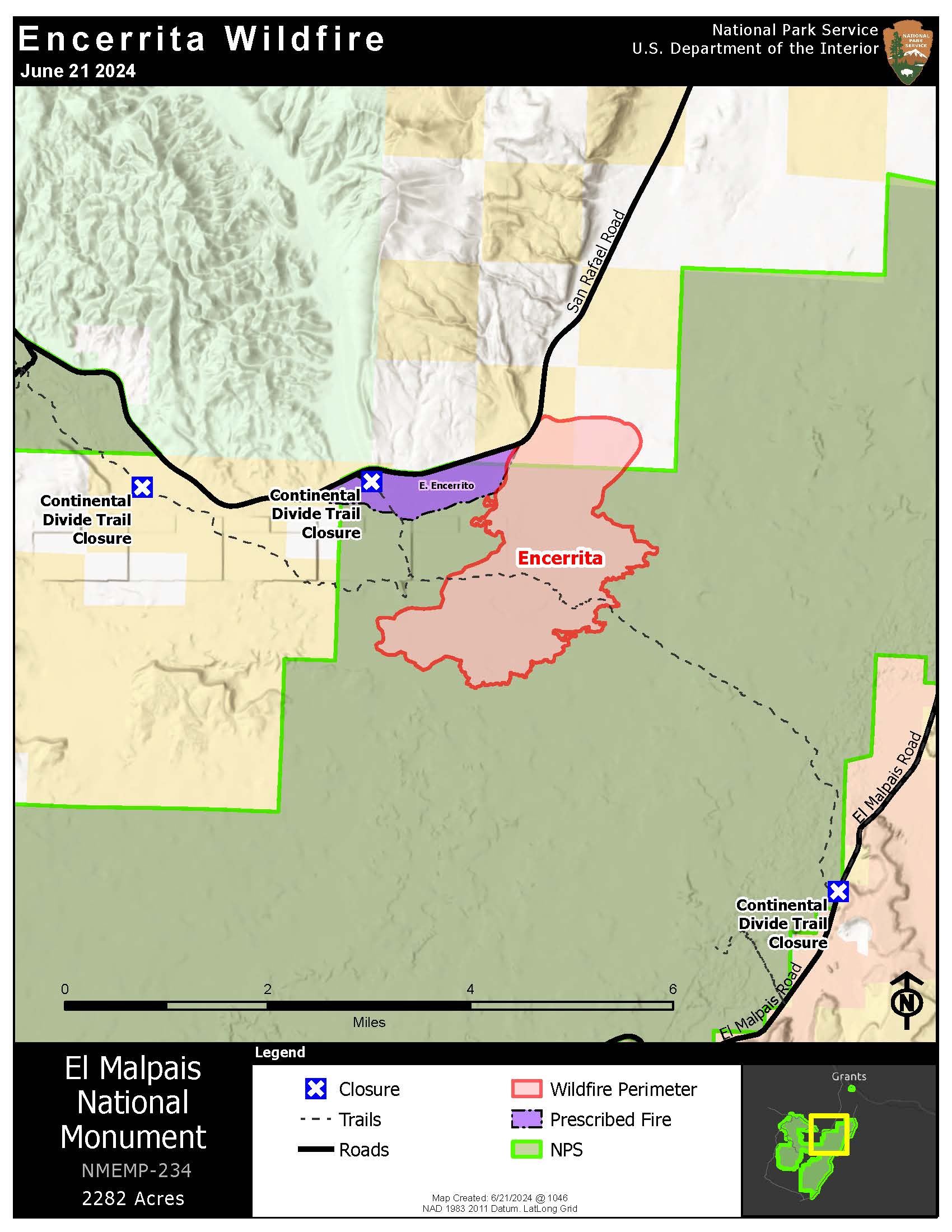
Frontal passage gives firefighters an edge on Encerrita Fire 06 21 2024
Related Incident: Encerrita Fire
Publication Type: News
The Encerrita Fire only gained 3 acres on Thursday due to higher humidity that followed a frontal passage. The 2282-acre lightning-caused fire is located in El Malpais National Monument, 15 miles south-southwest of Grants.
On Thursday firefighters were aided by high humidity and lighter winds while they continued to secure line and focus efforts on keeping the fire south and east of Highway 53. The western side of the fire progressed slowly toward the footprint of a prescribed fire that was completed by the NPS in April 2024. Growth to the south and east remained minimal and was slowed as it moved into lava fields and other areas with minimally available fuel.
Firefighters will continue line construction from the southwest corner of the fire to the Continental Divide Trail (CDT) and eventually to Highway 53 to the fire’s western edge as weather permits. Heavy precipitation with afternoon thunderstorms are expected today through the weekend, which will aid firefighting operations.
Closures remain in effect in the monument. The Continental Divide Trail (CDT) and Zuni-Acoma Trail are closed in El Malpais National Monument from Porter Ranch Rd off Hwy 53 to Hwy 117; a CDT bypass is in place between CDT miles 502.5 to 512.5; more information is available on the CDT website. Both the western Zuni-Acoma Trail parking lot and the eastern Acoma-Zuni Trail parking lot are included in the closure. Closures have been posted and the public is asked to avoid closed roads, trails, and parking lots. The El Calderon Trail remains open.
The El Calderon Trail remains open, but the bat flight programs scheduled for today, June 21, and tomorrow, June 22, have been cancelled due to incoming weather; please check with the visitor center for future changes upcoming program schedules that may occur.
Additional updates on the Encerrita fire will be available on Facebook (@ElMalpaisNPS) and on Inciweb. Please contact the El Malpais Visitor Center at (505) 876-2783 or visit www.nps.gov/elma for additional information on closures in the monument.
#EncerritaFire2024
Pioneer Fire update 06 21 2024
Related Incident:
Publication Type: News
Pioneer Fire Update for Friday, June 21, 2024
CHELAN, Wash. — The Pioneer Fire is burning in the Lake Chelan-Sawtooth Wilderness Area in the Chelan Ranger District of the Okanogan-Wenatchee National Forest and on private land 31 miles northwest of Chelan. Stehekin, Chelan and Manson are open and continue to welcome visitors. The hazardous terrain within the Wilderness requires careful planning to ensure firefighters can work safely to implement containment strategies with the greatest probability of success. Firefighters are engaged to protect structures along the lake shore as well as private and public lands.
Fire spread remains minimal, growing just 63 acres since Wednesday, burning most actively in the Cascade Creek area at the northerly end of the fire footprint and backing down the north side of Prince Creek.
Firefighters are establishing handline from the Fish Creek trail up a ridge to tie into a natural rock feature just shy of Moore Mountain. This indirect line is being constructed to minimize up-lake fire movement towards the North Cascades National Park boundary.
Structure prep work has reached Flick Creek and will continue north toward Stehekin. Fire personnel are also updating a structure protection plan for Stehekin and implementing contingency lines around dwellings, structures and critical infrastructure in the community of Stehekin.
Crews are continuing patrols around structures in Pioneer Creek. Additional crews are working in Prince Creek and Canoe Creek preparing for tactical firing operations should they be necessary.
An indirect line down Coyote Ridge is being established with the use of heavy equipment and hand crews. This line will tie into the lake shore. An additional indirect line is being scouted and implemented from Nelson Butte to the lake shore just east of Safety Harbor Creek.
Heavy equipment work to improve Grade Creek Road has reached mile marker 20.5 and brushing has reached mile marker 15. These improvements are needed to provide fire vehicles and equipment with a safe route to approach the fire from the southeast should the fire progress that direction.
Thursday, aviation resources provided reconnaissance flights to confirm scouting reports, delivered 7185 pounds of cargo, 12 passengers, and 5224 gallons of water for strategic water drops. Much less water was needed due to less active fire behavior. Additional helispots are being established at Stehekin and Twenty Five Mile Creek to reduce flight distances to the fire area.
Additional crews, equipment, and support personnel are arriving daily and being assigned to operating bases at Lucerne and Stehekin.
EVACUATIONS: Evacuation levels have not changed since Sunday, June 16. Please visit County of Chelan, Washington for the most current information on evacuations.
Smoke & Air Quality: https://bit.ly/PioneerFireSmoke. Learn more about health impacts and becoming Smoke Ready at smokeready.org.
To receive fire updates via email, sign up at https://lp.constantcontactpages.com/sl/PndMhvq
Public information: https://www.facebook.com/profile.php?id=61560760893080
E-mail: 2024.pioneer@firenet.gov
Phone: 509-210-2926 8 a.m.-5 p.m. daily
Washington Smoke Blog: https://wasmoke.blogspot.com/