
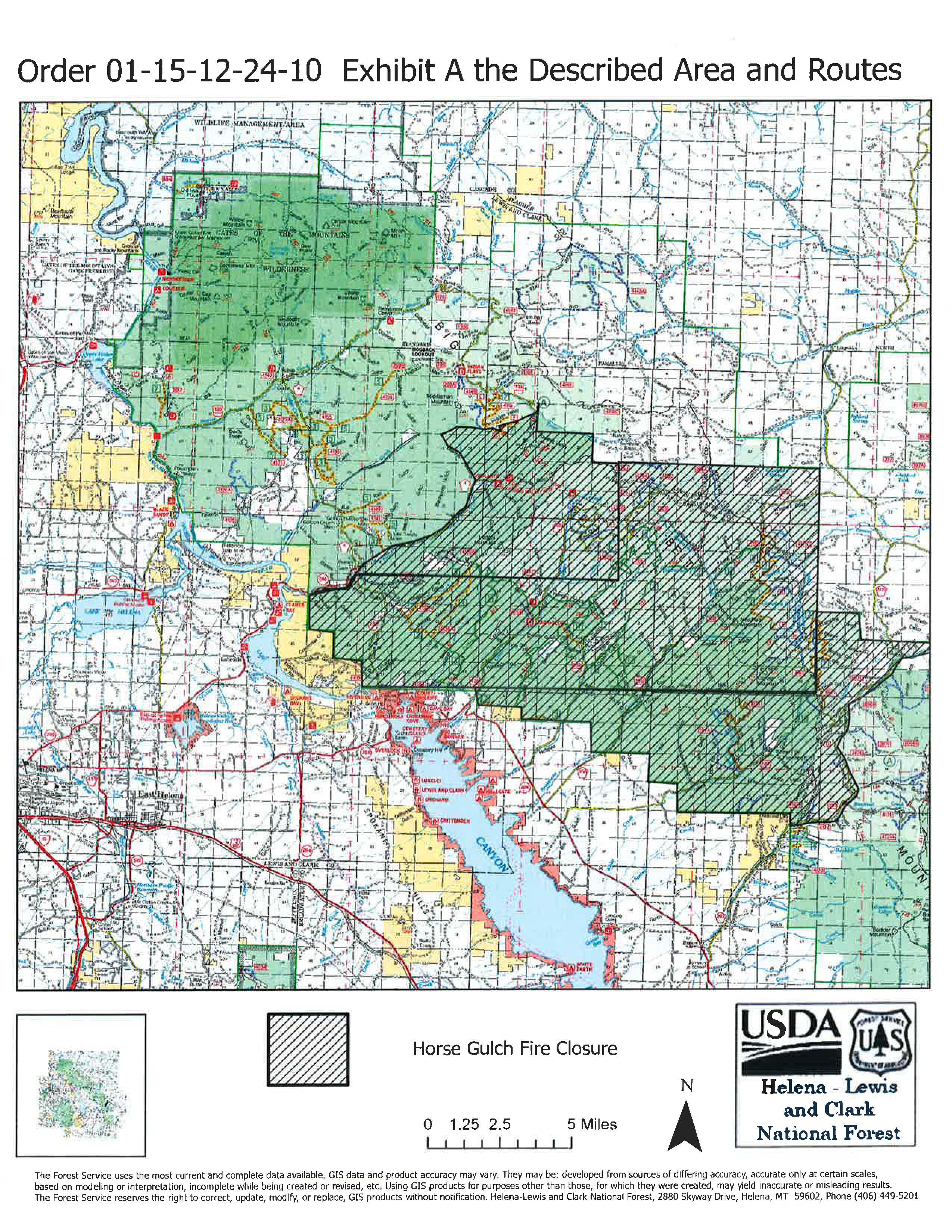
Signed Closure Order Horse Gulch Fire 07 16 2024
Related Incident: Horse Gulch Fire
Publication Type: Closures
Order Number: # 01-15-12-24-10
U.S. Department of Agriculture, U.S. Forest Service Helena-Lewis and Clark National Forest Helena and Townsend Ranger Districts
Area/Road/Trail Closure - Horse Gulch Fire
Graff Point Fire Update Tuesday July 16 2024 07 16 2024
Related Incident: Graff Point Fire
Publication Type: News
Cedar City, Utah –
Suppression efforts on the Graff Point Fire are yielding positive results, with crews making significant progress in constructing handlines. Current activities include mopping up and cold trailing to ensure the fire remains within its established perimeter. Cold trailing involves firefighters carefully inspecting the burned area to ensure no hot spots or embers remain, often using their hands to feel for heat. Mopping up is the process of extinguishing remaining hot spots, turning over smoldering debris, and thoroughly stirring and sometimes wetting down the area. Although some occasional torching was observed, the fire has stayed within yesterday's footprint. Night operations were conducted last night and will continue.
Despite recent precipitation, the fuels remain dry, resulting in some interior creeping and torching. Aircraft are being utilized as needed, specifically on the south side where the terrain is steep, to provide water drops in areas difficult to access by firefighters on the ground. The chance of isolated thunderstorms is expected to develop today, and temperatures will be in the mid-80’s.
A community meeting will be held today, July 16, 2024, at 6:30 p.m. The Graff Point Fire community meeting will be hosted in person at:
Heritage Center Theatre
105 N 100 E, Cedar City, UT 84720
Doors open at 6:15 p.m.
There will also be a virtual Zoom option available: https://tinyurl.com/GraffPointFireInfo
For information regarding evacuations, please contact the Iron County Sheriff. We kindly ask that you respect these measures and avoid the area. For more information, please visit: https://inciweb.wildfire.gov/incident-information/ututs-graff-point-fire or utahfireinfo.gov
2024 SQF Lightning Daily Incident Update 07162407 16 2024
Related Incident: 2024 SQF Lightning
Publication Type: News
Acorn Fire: 7 acres
Packsaddle Fire: 50 acres
Trout Fire: 2,095 acres
Total Personnel: 155
Current Situation: California Interagency Incident Management Team 14 assumed command of the 2024 SQF Lightning Incident on July 15, 2024, which includes the Acorn, Packsaddle, and Trout Fires, all burning within the Sequoia National Forest. Full suppression efforts are being implemented for each of these fires. With continued extended hot and dry conditions experienced in much of the western United States, critical resources are drawn down due to multiple large incidents. As resources on the incident complete suppression efforts on the smaller two fires, Acorn and Packsaddle, crews will be redirected to the Trout Fire.
Acorn Fire: Firefighters have worked tirelessly to construct control lines around the entire fire perimeter of the Acorn Fire. Located south of Breckenridge Road near the Breckenridge Campground within Kern County, this fire is being held at approximately 7 acres. Yesterday, crews utilized hoselines and water to mop up and extinguish remaining hot spots. Crews will continue to strengthen and hold these containment lines with the goal of placing the fire into patrol status and redirecting resources to the Trout Fire.
Packsaddle Fire: The Packsaddle Fire remained smoldering and creeping on Monday allowing firefighters to complete control lines around the perimeter as well as around multiple spot fires from the previous day. The fire’s growth had been slowed using aerial retardant that allowed crews to use direct attack methods. The fire remains at approximately 50 acres and is located 4 miles east of the Fairview Campground within Tulare County. Today, crews will ensure that containment lines are holding with no threat of escape and redirect resources to the Trout Fire.
Trout Fire: The Trout Fire is the most active of the three fires and burning in an area of no recent fire history. The fire is approximately 2,095 acres and burning in the Trout Creek and Machine Creek drainages. The topography within the Dome Land Wilderness in Tulare County is steep, rugged, and mountainous. Aircraft continue to support the incident through retardant drops to hold the fire from spreading in key locations. Firefighters and resources are being positioned to stop the fire’s northern and eastern spread.
Weather: A slow downward trend in temperatures and probability of thunderstorms remain forecasted for this week while higher temperatures are expected for the weekend. Fuels remain critically dry, which allows for rapid and intense burning conditions.
Evacuations: There are currently no evacuations in effect for this incident. Please be aware of your surroundings and continue to monitor fire conditions.
Fire Closures: Forest Order No. 0513-24-11 has been issued to provide for public safety due to the Trout Fire. Fire restrictions are also in effect on the Sequoia NationalForest. See Forest Order No. 0513-24-10 for details (tinyurl.com/4pdjthvu).
Crews Transition to Containment Work 07 16 2024
Related Incident: Yeso Fire
Publication Type: News
With the Yeso Fire spread throughout the predetermined confinement area, Carson National Forest fire crews today are continuing to focus on securing the fire’s edge.
Yesterday, crews evaluated interior portions and physically walked the boundary of the predetermined area with a GPS unit. Now with better mapping, the predetermined area—and the fire’s size—is 650 acres, confined primarily by existing roads. Containment remains at zero.
“We’ve had line around the fire for days,” said District Ranger Angie Krall, “but we want to make sure there is no chance of it spilling over before reporting containment increases.”
Crews take several actions to secure the line and increase containment, including monitoring outside the predetermined area for spots, moving heavier fuels on the line into the interior, mopping up against roads and chipping road-adjacent ladder fuels that were removed last week.
Although ignitions are complete, fire managers expect some residual smoke to continue to be visible this week.
The lightning-caused Yeso Fire was first reported on July 9. For safety, crews are using a less aggressive strategy to indirectly contain the fire, primarily along existing roads, while it provides ecosystem benefits within the interior.
The area remains open, including the Continental Divide National Scenic Trail and Forest Service roads. The driving public is asked to slow down for fire personnel.
An overview of the Yeso Fire suppression strategy and area fire ecology is available on the Carson National Forest website. Public information officers are updating InciWeb and can be reached at 505-216-6793.
This will be the final regular Yeso Fire update unless conditions change.
Shelly Fire Morning Update 07 16 2024
Related Incident: Shelly Fire
Publication Type: News
Location: Siskiyou County, CA
Size: 15,317 acres
Cause: Under Investigation
Start Date: Wednesday July 3, 2023, at 1:27PM
Percent Contained: 5%
Personnel: 3,263
CURRENT SITUATION:
Yesterday, a second round of thunderstorms swept over the fire area, bringing increased wind and precipitation. Rainfall varied, with some areas receiving only one tenth of an inch. Despite the rain, it was not sufficient for the entire fire perimeter, still leaving a threat.
Overall, the weather conditions were beneficial for suppression efforts. Lower temperatures and higher humidity levels enabled firefighters to directly confront areas with high fire intensity.
Today, our resources will focus going direct on Shackleford Ridge, progressing southwest towards Campbell and Cliff Lakes. The structure group will continue to prioritize protection in Quartz Valley, Greenview, Etna, and surrounding areas. Over 3200 personnel are diligently working to combat the Shelly Fire and ensure the safety of the community.
Hwy 3 is open with traffic control from Etna to Fort Jones for public and firefighter safety. Drivers in the Shelly Fire area are reminded to slow down and remain alert for heavy equipment and fire personnel on or near the roadways.
WEATHER:
Tuesday brings another day of possible thunderstorms causing erratic winds over and around the fire through this afternoon. Although humidities will continue slightly higher today they begin to drop and temperatures increase later in the the week.
EVACUATIONS:
Multiple Evacuation orders and warnings remain in effect. For current updates on evacuations, visit www.facebook.com/SiskiyouCountySheriff and www.facebook.com/SiskiyouCountyOES Additional evacuation information and a map can be found on the Genasys site at: https://protect.genasys.com/search?z=14&latlon=41.550694%2C-122.905589
SHELTERS:
Kahtishraam Wellness Center - Yreka 1403 Kahtishraam, Yreka, CA 96097 Showers and cots are available.
RV Dry Camping/Parking
West Webb St. and Hoag St. in Montague
Please note, at this time, there are no extra services (sewage/water/power hookups). This is currently set up for DRY camping.
𝗔𝗡𝗜𝗠𝗔𝗟 𝗦𝗛𝗘𝗟𝗧𝗘𝗥𝗦
Animal shelters are available at the following locations(s) for those who have pets and animals that been displaced due to the Shelly Fire:
Dog Evacuation Shelter:
Rescue Ranch Yreka
2216 East Oberlin Road, Yreka CA 96097 Contact: John Golay 541-698-7526
Livestock Animal Evacuation Shelter (Horses, pigs, sheep, goats, birds):
Siskiyou Golden Fair
1712 Fairlane Road, Yreka, CA 96097 Contact: Tom Taylor 530-340-1038
Cat Evacuation Shelter:
Siskiyou Golden Fair - Armory Building 1712 Fairlane Road, Yreka, CA 96097
Contact: Becca 530-340-0656
CLOSURES:
An official closure area around the Shelly Fire went into effect on July 4th. Hikers are not permitted in the area and will be asked to leave the area. For details and a map of the closure are, please
visit https://www.fs.usda.gov/Internet/FSE_DOCUMENTS/fseprd1187463.pdf.
FIRE RESTRICTIONS:
Forest fire restrictions also went into effect on July 4th. Campfires and stove fires are restricted to those developed areas listed in the forest order located at https://www.fs.usda.gov/alerts/klamath/alerts-notices/?aid=88596.
Smoking, welding, and operating an internal combustion engine also have restrictions in place.
Pacific Crest Trail Information: https://www.pcta.org/discover-the-trail/closures
Speirs Fire Update July 16 2024 07 16 2024
Related Incident: Speirs Fire
Publication Type: News
The fire is zero percent contained with approximately 95 personnel assigned to the incident. The size of the fire is now 712 acres.
Monday’s activity was light due to cloud cover and afternoon showers. Fire growth did occur on the southern side of the fire towards Greens Draw. As large fuels continue to burn, smoke may be noticeable in the area.
Crews will continue to secure the north and west side of the fire through direct measures, creating hand line and extinguishing fire spotting. The current reduced fire behavior may provide an opportunity to gain additional foothold in suppression efforts. The fire is burning in steep and rugged terrain with minimal access, and aerial resources will continue to assist in suppression efforts.
Today’s conditions are expected to be similar being mostly sunny in the morning with afternoon showers, lightning and gusty erratic winds.
There are currently no evacuations, closures of campgrounds or developed recreation sites, or campfire restrictions in place. However, due to the proximity of the fire, future closure of the Greens Draw area and some developed recreation sites is anticipated.
Despite the reduction in fire behavior, visitors and residents in the area are encouraged to remain observant. Warmer temperature can dry out vegetation quickly and increase fire activity.
Management of the fire will transition to the Great Basin Incident Management Team 3, a Complex Incident Management Team (CIMT), on Wednesday.
Watch Fire Update Tuesday 07 16 2024
Related Incident: Watch Fire
Publication Type: News
Watch Fire: 2,162 acres
Start Date: July 11, 2024
Cause: Human Caused, Under Investigation
Fuels: Cottonwood, Brush, Understory
Containment: 81%
Resources: 185
Location: 7 Mile and Peridot Districts, San Carlos Reservation
Watch Fire Reaches 81 Percent Containment
Overview: Yesterday, more containment was added to the southeast and northern corners of the Watch Fire. There was no additional smoke from burned structures or other concerns as crews continued working. Firefighters were able to focus their efforts on finalizing containment around the fire. Today, firefighters will continue working to gain the final containment along the remaining non-contained perimeter. Any residents returning to evacuated areas who may have questions or concerns are asked to contact the San Carlos Apache Emergency Operations Center (information below).
Weather: Watch Fire is expected to see temperatures around 100 degrees in lower elevations with light west/southwest winds between 5-15 mph and gusts up to 25 mph. Increasing cloud cover with a 50 percent chance of rain. There is a high probability of lightning over the next few days.
Safety: Additional fire personnel are available to respond to any new fires which may occur in the area. Increased traffic continues to impact roads in and around the fire. Please drive with caution. Please do not fly drones anywhere near the fire. Drones can endanger firefighting aircraft. If you fly, we can’t.
Smoke: Smoke-sensitive individuals and people with respiratory problems or heart disease are encouraged to take precautionary measures.
Evacuations: The following communities have been downgraded from “GO” (evacuate) to “SET” (be alert) Status; Lower Seven Mile Wash, New Moonbase, San Carlos Apache Healthcare Corporation, Farmers Station, Downtown San Carlos and Peridot Siding. Residents are asked to avoid burned structures due to hazardous materials that may have long term health effects. For more information, call the San Carlos Apache Tribe Emergency Response Commission at 928-475-2008 or visit TERC or the San Carlos Police Department Facebook pages, see below.
Pioneer Fire Daily Update 07 16 2024
Related Incident:
Publication Type: News
Pioneer Fire Update for July 16, 2024
Incident Commander Jeff Dimke
Complex Incident Management Team Northwest 12
541-861-5808, staffed 8 a.m. to 8 p.m. 2024.pioneer@firenet.gov
Size: 20,348
Start Date: June 8, 2024
Location: 31 miles NW of Chelan, WA
Containment: 14%
Personnel: 794
Cause: Human-caused, under investigation
Resources Assigned: 14 crews, 9 helicopters, 18 engines, 22 water tenders, 18 heavy equipment
There will be a Manson community meeting on Wednesday, July 17th at 5:30 PM at the Manson High School. The meeting will also be streamed live on the Pioneer Fire Information Facebook page. Please submit questions in advance to 2024.pioneer@firenet.gov or via Facebook Messenger.
There will be a Stehekin community meeting on Thursday, July 18th at 6 PM at the Golden West Visitor Center.
The Pioneer Fire is burning within a mountainous and remote area on the Okanogan-Wenatchee National Forest near Lake Chelan. Firefighters are using a full suppression response in the Lake Chelan-Sawtooth Wilderness to protect values at risk, life, and property, with firefighter and public safety as the primary objective. The communities of Chelan, Manson, and Stehekin are open and continue to welcome visitors.
Operations: Firefighters completed a hose lay system around Stehekin Valley Ranch yesterday and engaged in small-scale firing operations south of Moore Point to protect structures and infrastructure in the area. Crews improved sprinkler systems around private property along the lakeshore and structure protection assessments continued in Manson. An Uncrewed Aerial System with thermal sensors flew in the area of Lone Fir and detected no heat. Heavy helicopters dropped multiple buckets of water on the fire and additional helicopters flew in 2,000 lbs of cargo including equipment and provisions to firefighters on the line.
Today, firefighters are staffing five Washington Department of Natural Resources engines in Stehekin and additional fuels reduction will continue along roads. Interagency Hotshot Crews will initiate limited point protection firing operations as needed, bringing fire up-lake from the foot of Round Mountain. Equipment continues to undertake the extensive contingency line construction along Cooper Ridge. Firefighters are expected to finish hand line from Cooper Ridge down to Lake Chelan. New resources are arriving daily to replace those timing out including handcrews, falling modules, and single resource personnel.
Safety and Closures: The Okanogan-Wenatchee National Forest has a closure order in place for much of the fire area. Details and maps are available at: https://bit.ly/PioneerClosure. The Temporary Flight Restriction (TFR) in place over the fire was expanded yesterday: https://tfr.faa.gov/save_pages/detail_4_6779.html. Drone activity is prohibited under the TFR, as helicopters cannot fly with unauthorized drones present.
Evacuations: Level 1, 2 and 3 evacuation levels remain in effect around the Pioneer Fire. Please visit https://t.ly/QoH9w for more information.
Weather and Smoke: The high-pressure ridge, which is bringing above-average temperatures and low humidity, will move out of the area today. Winds will transition to a southeast/southwesterly flow, with a 20% chance of dry lightning on Wednesday. The air quality outlook can be found at: https://bit.ly/PioneerFireSmoke. Learn more about smoke at http://wasmoke.blogspot.com/. The fire marshal issued fire danger ratings and restrictions: https://t.ly/WLBds.
Buckhorn Fire Update Tuesday 07 16 2024
Related Incident: Buckhorn Fire
Publication Type: News
Buckhorn Fire: 561 acres
Start Date: July 10, 2024
Cause: Suspected lightning
Fuels: Timber, Brush, Understory
Containment: 0%
Resources: 105
Location: Maylay Gap Area, San Carlos Reservation
Firefighters Continue Work to “Box in” the Buckhorn Fire
Overview: Yesterday, the Buckhorn Fire burned its way to the Black River on the western perimeter. The fire movement was slow, with low-to-moderate behavior. Crews removed vegetation along the 2034 Road and that work is expected to be completed today. Crews then began defensive burning operations to remove vegetation ahead of the main fire on the southeastern and southwestern perimeter. Firefighters located old dozer lines along many of the ridges, which may be used to slow the fire’s progress. Today, firefighters will be moving north along the 2030 Road, working to remove vegetation. Crews will continue to construct stronger lines which should be more secure in stopping the fire’s progress in areas that are easier to access.
Weather: Yesterday brought more isolated thunderstorms around the Buckhorn Fire. Today, storm cells will continue to develop and move erratically throughout the afternoon. Temperatures are expected to be between 83-86 degrees with west/northwest winds 5-7 mph, gusting to 15 mph. Chance of rain is about 65 percent.
Safety: Please do not fly drones anywhere near the fire. Drones may endanger firefighting aircraft. If you fly, we can’t.
Closures: There is an area closure in place around the Buckhorn Fire. Closures are being adjusted based on fire activity for public and firefighter safety. Please monitor the San Carlos Apache Tribe Facebook Page for updated information. (Link Below)
Smoke: Smoke-sensitive individuals and people with respiratory problems or heart disease are encouraged to take precautionary measures.
Ko’ doo bena golde’ da
Salt Creek Fire Daily Update 07 16 2024
Related Incident: Salt Creek
Publication Type: News
Salt Creek Fire 73% contained, team transition planned
EAGLE POINT, Ore. – The Salt Creek Fire continues to gain containment as firefighters push forward on mopping up; it’s now 100% lined and 73% contained. Due to this progress, Oregon Department of Forestry (ODF) Incident Management Team 1 is beginning the process of transitioning the fire back to the local districts to continue working on the incident. During this time, resources will begin to demobilize, allowing some of those personnel and equipment to be reassigned to other fires burning across the region.
With this transition, 961 personnel are assigned to the fire for Tuesday’s day and night shifts, including 37 crews, 28 engines, seven bulldozers and 17 water tenders. Aircraft include four Type 1, one Type 2 and two Type 3 helicopters, and additional aircraft will be ordered if necessary.
These resources will continue to mop up into the interior of the fire and get as much of the fire contained as possible before turning it back over to the local districts.
The Jackson County Sheriff’s Office and Emergency Management have canceled two of the Level 1, “BE READY,” evacuation notices for zones JAC-19 and JAC-21. The rest remain in effect at this time. Learn more about evacuations at: https://protect.genasys.com/
BLM Medford District has temporarily closed BLM-managed lands in the area for safety. For more info go to: https://www.blm.gov/orwafire
The current fire danger level is extreme; follow all fire restrictions to help prevent fires. Learn more at:
- The ODF Southwest Oregon District: https://swofire.com/
- The RRSNF Alerts and Notices page www.fs.usda.gov/alerts/rogue-siskiyou/alerts-notices and website homepage www.fs.usda.gov/rogue-siskiyou
- The BLM OR/WA Fire Management Page: www.blm.gov/orwafire
The Salt Creek Fire is located 10 miles east of Eagle Point and was first reported Sunday, July 7, just after 4 p.m. The cause is under investigation.