
Ridge Fire Daily Update 07 17 2024
Related Incident:
Publication Type: News
Fire activity cools as precipitation falls on the Ridge Fire
Daily Update – Wednesday, July 17, 2024
Acres: 4,123
Start Date: 7/4/2024
Location: 19 miles east of Glenwood, NM
Personnel: 281
Containment: 23%
Fuels: Timber, grass, understory
Highlights: Fire activity has generally cooled with the precipitation received on the north end of the fire area. Some increased fire activity was observed in Iron Creek on the southeast side as the fire slowly moved downslope into the drainage. Heavier rainfall later this week is expected to further dampen the intensity and spread of the fire.
Operations: Yesterday, local Resource Advisors received seeds to scatter across those areas disturbed by fire operations, such as supply drop points and camps. Seeding will occur in highest concentrations on steep slopes to prevent future erosion. High cloud coverage, humidity, and slight precipitation on the north end of the fire resulted in limited burning, with minimal fire activity including creeping and smoldering. No helicopter flights occurred due to weather conditions. However, uncrewed aircraft systems (UAS) were able to observe an area where the fire moved into Iron Creek east of Cooper Canyon. Firefighter efforts have resulted in increased containment around the Iron Creek area as crews continue to patrol Trail #151. Firelines continue to hold steady in Gilita Canyon along the north side of the fire. Chipping operations continue along the road into the Willow Canyon community to create a strong defense against any potential wildfire spread. This process involves breaking down large vegetation and other combustible materials into small wood chips to prevent the spread of wildfire. Near the Willow Creek community on the western side of the fire, firefighters completed water bar installation to prevent future erosion in time for predicted heavier rainfall. As work is completed, operational resources are being released to support other wildfires across the region. A Burned Area Emergency Response team has been ordered to assess and strategize restoration and stabilization efforts for burned areas.
Weather: The coverage of showers and thunderstorms will be even greater today and could produce locally heavy rainfall and gusty and erratic outflow winds. Temperatures may only be slightly cooler and humidity levels slightly greater than Tuesday. Winds will become southerly during the day, with speeds of 8 to 12 mph with higher gusts.
Smoke: Smoke may be visible from Mogollon, Willow Creek, and Snow Lake. An interactive smoke map at https://fire.airnow.gov/ allows you to zoom into your area to see the latest smoke conditions. Smoke monitors are in place at the Glenwood Ranger Station, Cliff, and Gila Cliff Dwellings.
Closures: The Gila National Forest has issued an emergency temporary closure of trails and trail segments for the Ridge Fire. The purpose of the closure order is for the protection of firefighters and public health and safety during emergency wildfire suppression activities occurring in and around the trails. The full closure order (No. 03-06-05-24-002) and map are available on the Gila National Forest website at https://www.fs.usda.gov/gila.
Safety: The health and safety of firefighters and the public are always the first priority. A temporary flight restriction (TFR) is in place over the area, which includes uncrewed aircraft or drones. Flying drones near wildfires is dangerous for pilots and firefighters and can bring wildfire suppression efforts to a halt. Know before you fly. If you fly, we can’t. More information can be found at: https://uas.nifc.gov/.
More Information: https://inciweb.wildfire.gov/incident-information/nmgnf-ridge-fire /
575-323-8994 / https://www.facebook.com/GilaNForest / 2024.ridge@firenet.gov
Speirs Fire Daily Update July 17 2024 07 17 2024
Related Incident: Speirs Fire
Publication Type: News
Daily Update, July 17, 2024: #SpeirsFire
Great Basin Complex Incident Management Team 3 assumed command of the Speirs Fire at 6 am today. Incident Commander Brett Waters thanked Tom Wilson, Zac Farmer, and the Type 3 Incident Management Organization made up of from local firefighting professionals. "Their outstanding work on the initial attack has given us a solid foundation to build on," Commander Waters said.
Recent wetting rains have significantly reduced fire intensity. This muted fire activity will allow crews to construct containment features directly along much of the fire's perimeter. This direct attack will help contain the fire in the smallest possible footprint. Along portions of the northern flank, the fire burned unevenly, creating fingers of fire that pushed north and left unburned fuels between them. Here, firefighters will use an indirect attack method to remove these unburned fuels and create a more uniform and manageable containment line.
One of the significant challenges firefighters face in suppressing the Speirs Fire is the lack of roads to bring personnel and equipment to the fire area. To address this, we are creating a remote 'spike' camp. This camp will allow firefighters to stay nearer the fire, eliminating many hours of hiking and allowing that time to be invested in containing the fire. Helicopters will fly in food and supplies to support the firefighters in their remote camp.
A ridge of higher pressure will build over the fire area today, reducing the chance of wetting rain. However, this high-pressure ridge should subside by Thursday, bringing the possibility of additional precipitation over the fire area. Along with the possibility of wetting rain, this pattern of afternoon thundershowers also carries the risk of erratic outflow winds that could push the fire in unexpected directions. This is a serious concern, and team safety officers will make every effort to mitigate the risk to firefighter safety.
Closures:
Being on or within the following campgrounds, roads, and trails are prohibited on the Flaming Gorge Ranger District on the Ashley National Forest: Firefighters Memorial Campground, Greendale Group Campsite, Forest Service Road (FSR) 610, FSR 689, Lowline trail FST103 its junction with the Pipe Creek Trail, FST 003. Forest Service Trail 003 from the beginning at the junction with FST 103 to the junction of Forest Service Trail 004 and Forest Service Trail 004 to Greens Draw Road 049. For more information on existing closures, please visit the Ashely National Forest website at https://www.fs.usda.gov/alerts/ashley/alerts-notices
Temporary Flight Restrictions (TFR): A TFR is in effect over the Speirs Fire area. Using uncrewed aerial systems (UAS)/drones is illegal within the TFR.
Speirs Fire Incident Website: https://inciweb.wildfire.gov/incident.../utasf-speirs-fire
Start date: July 13, 2024
Location: Approximately three miles south of the town of Dutch
John, Utah and south of Flaming Gorge Reservoir.
Fire size: 759 acres
Containment: 3%
Total personnel: 230
Cause: Naturally-Caused, Lightning
Speirs Fire Information Number: 435-709-8209 (8:00 AM to 8:00 PM.)
Bench Lake Fire Update 07 17 2024
Related Incident: Bench Lake Fire
Publication Type: News
Start Date: July 11, 2024
Cause: Under Investigation
Size: 1,850 acres
Percent Containment: 3%
Helicopters: 4
Scooper Planes: 2
Engines: 13
Crews: 9
Total Personnel: 324
Yesterday on the Bench Lake Fire, crews began using fire as a buffer to burn vegetation between the 101 Trail and the northern edge of the main fire. By intentionally setting fire, crews are creating a break in continuous fuels, reducing fire intensity as it approaches the trail and limiting spread beyond the trail. If conditions prove favorable later today, crews plan to complete the backfire to guide the main fire to the wet, marshy area of Fishhook drainage in the northeast to slow progression of the fire. Incident managers were pleased with the effectiveness of the backburning.
Crews continued structure protection actions throughout the Redfish Lake area, which includes mitigating impacts to historical buildings and areas of cultural significance. The fire is currently above Point Campground, but no damage to the campground has been reported.
South winds of 15 to 25 mph are expected today with temperatures in the mid-80s. Increased smoke across the Stanley Basin was visible yesterday starting in the late morning, a trend which is likely to continue throughout the week. Those who are sensitive to the smoke should limit time outdoors.
The Sawtooth National Forest initiated Stage 1 fire restrictions within the National Forest System lands boundaries on the Sawtooth and Cassia zones, which became effective at 12:01 this morning. Under these restrictions, campfires are allowed only in recreation sites within metal or concrete fire pits. Fires of any kind are not allowed in any dispersed camping areas.
Community Meeting: Today, Wednesday, July 17 at 7:00 p.m. at the Community Building in Stanley, Idaho (500 Eva Falls Ave.)
Closures: Sawtooth National Recreation Area officials issued an emergency closure for the Bench Lake Fire (0414-04-147) July 12 for the Redfish Lake recreation complex, including the lodge and associated buildings, roads, trails, trailheads, and campgrounds in the area. Visit https://www.fs.usda.gov/alerts/sawtooth/alerts- notices for a map and more details on the closure order. Both Highway 21 and Highway 75 remain open. Increased fire traffic and potential poor visibility warrant slowing down.
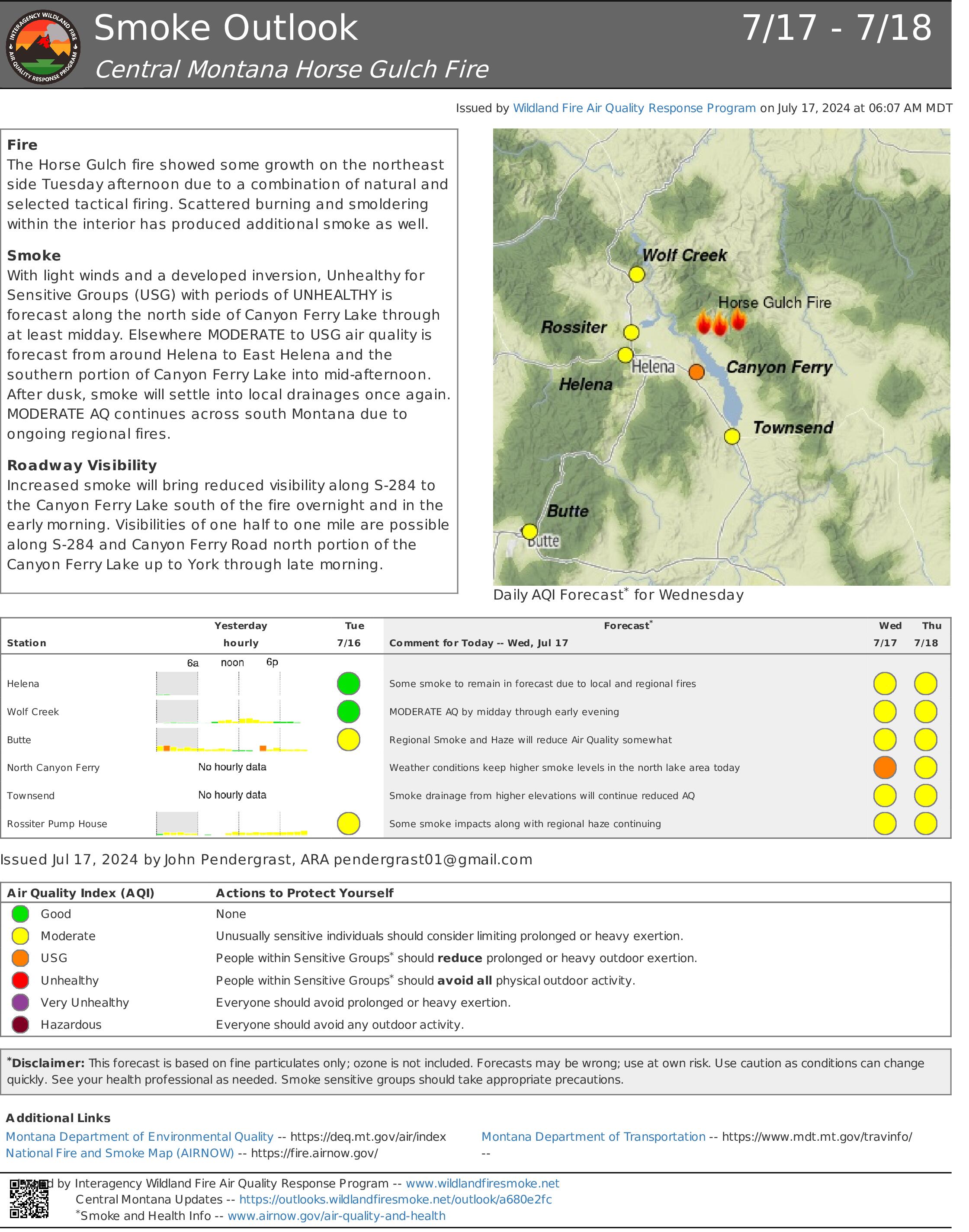
Horse Gulch Smoke Outlook 07 17 2024
Related Incident: Horse Gulch Fire
Publication Type: News
Fire
The Horse Gulch fire showed some growth on the northeast side Tuesday afternoon due to a combination of natural and selected tactical firing. Scattered burning and smoldering within the interior has produced additional smoke as well.
Smoke
With light winds and a developed inversion, Unhealthy for Sensitive Groups (USG) with periods of UNHEALTHY is forecast along the north side of Canyon Ferry Lake through at least midday. Elsewhere MODERATE to USG air quality is forecast from around Helena to East Helena and the southern portion of Canyon Ferry Lake into mid-afternoon. After dusk, smoke will settle into local drainages once again. MODERATE AQ continues across south Montana due to ongoing regional fires.
Roadway Visibility
Increased smoke will bring reduced visibility along S-284 to the Canyon Ferry Lake south of the fire overnight and in the early morning. Visibilities of one half to one mile are possible along S-284 and Canyon Ferry Road north portion of the Canyon Ferry Lake up to York through late morning.
BAER INFORMATION BRIEF Understanding Soil Burn Severity 07 16 2024
Related Incident: Basin Post-Fire BAER
Publication Type: Announcement
Burned Area Emergency Response (BAER) Information Brief: Understanding Soil Burn Severity
We tend to think of wildfire burn severity in terms of the visual impacts to above-ground vegetation, but the post-fire landscape response (erosion, flooding, and mass movement) is generally more strongly correlated to soil burn severity. When characterizing soil burn severity, looking at the vegetation is a good starting place to understand the conditions on the ground.
Armed with that information, the BAER team’s watershed specialists (soil scientists, hydrologists, and geologists) ground-truth different vegetation burn intensities to tease out patterns of how fire affected and changed the properties of the soil. Pre-fire ground cover, forest type, fire behavior, slope, aspect, and other factors all influence soil burn severity. After field observations are collected, specialists adjust the vegetation severity map to create the soil burn severity (SBS) map. The SBS is broken into four different classes: unburned (green), low severity (blue), moderate severity (yellow), and high severity (red).
So, what do these different classifications mean?
LOW severity areas generally have intact and recognizable litter layers (organic material on the forest floor, such as pine needles and twigs). These litter layers may be charred but are not consumed. Underlying topsoil is intact, and near-surface fine roots are unburned. These soils have enough cover to protect them from erosion during rain events because their natural porosity and structure allow rain to soak into the soil instead of running off, while fine roots provide stability. In low severity areas, burns may have been patchy islands of green vegetation and intact canopies may be present.
MODERATE severity areas generally have more—up to 80% of their pre-fire surface litter layers consumed by fire. Black or gray ash may be present on the soil surface. Fine roots near the surface may be scorched and killed. Topsoil layers are generally intact with minimal impacts to the soil’s ability to absorb moisture. Soils with moderate severity are more susceptible to erosion in post-fire rain events because they have lost protective surface cover and may have less surface stability because of root mortality.
HIGH severity areas generally have had all their pre-fire surface litter layers consumed by fire. White or gray ash may be present on the soil surface. Fine roots are often fully burned/consumed within several inches of the soil surface, and even large tree roots may have burned deep into the soil. Soil may be powdery or grainy and loose, unable to bind together and retain water. These soils are very susceptible to erosion and often have high surface run-off during rainstorms.
So, what does the BAER team do with the SBS map?
The BAER team uses the SBS map to make predictions about how the landscape will respond after fires. Soil scientists consider where soil productivity will be degraded due to erosion losses and where sediment may move into stream channels. Hydrologists use the SBS to predict watershed response—surface runoff from high SBS areas in rainstorms can produce more “flashy” behavior in stream systems. Geologists use the SBS to inform predictions for debris flow or other mass movement potential based on reduced soil stability in steep drainages.
BAER teams focus on emergency responses to stabilize burned areas that may impact Forest Service critical infrastructure or other values located within or immediately downstream of high soil burn severity areas.
BAER SAFETY MESSAGE: Everyone near and downstream from the burned areas should remain alert and stay updated on weather conditions that may result in heavy rains and increased water runoff. Flash flooding may occur quickly during heavy rain events--be prepared to act. Current weather and emergency notifications can be found at National Weather Service website: www.weather.gov/hnx/.
Hill Fire Evening Update 07 16 2024
Related Incident: Hill Fire
Publication Type: News
Eureka, CA., July 16, 2024—
The Hill Fire is approximately 2,000 acres and is growing at a rapid rate with extreme fire behavior. The fire continues to burn in steep and remote terrain making access challenging for ground resources. Air resources including air tankers, helicopters, and air attack are on scene and performing retardant drops to try and slow the spread. The fire is growing to the north in heavy timber as fire conditions continue to be hot and dry.
Evacuation Order issued for Zone HUM-E077A and Evacuation Warning issued for Zone HUM-E077-B . The Six Rivers National Forest will continue to work with our partners at the Humboldt County Sheriff’s Office to determine the need for additional evacuation orders and warnings as conditions warrant.
Evacuation Information
Evacuation Order Issued for Zone HUM-E077A: Due to the Hill Fire, the Humboldt County Sheriff’s Office has issued an immediate evacuation order for zone HUM-E077-A North of White Oak Creek/Grouse Creek, South of Friday Ridge Road, Forest Route 6N08A, East of Titlow Hill Rd, Twin Lakes Creek, West of Mosquito Creek/Madden Creek. Those in this zone should leave now for their safety.
Evacuation Warning Issued for Zone HUM-E077-B: Due to the Hill Fire, the Humboldt County Sheriff’s Office has issued an evacuation warning for zone HUM-E077-B North of PG&E Rod, Grouse Creek, South of Madden Creek, Forest Route 6N06, East of Mosquito Creek/Madden Creek, West of Trinity County Line. Prepare for potential evacuations, including personal supplies and overnight accommodations. Those in this zone should prepare to leave at a moment's notice. More information will follow if an evacuation order is issued.
Conditions are subject to change at anytime. Please visit protect.genasys.com for a full zone description. For more information regarding evacuations please call the Humboldt County Sheriffs Office at 707-268-2500 or go to humboldtsheriff.org/emergency.
Sign up for Humboldt Alert emergency notifications at humboldtgov.org/alert.\
For more information on evacuation orders and warnings, call 707-268-2500.
Additional Fire Information
The Hennessey 2, Ridge 2, and Waterman Fires are all staying within their fire perimeters of less than a quarter acre each.
Community Meeting July 172024 at 7pm 07 16 2024
Related Incident: Shelly Fire
Publication Type: Announcement
A community meeting will be held tomorrow Wednesday July 17, 2024, at 7:00 p.m. at the Etna High School. 400 Howell Ave. Etna CA 96027.
This meeting will be livestreamed on both the Klamath NF and CAL Fire Siskiyou Unit Facebook pages
Tonto National Monument Closure Order 07 16 2024
Related Incident: Black Fire
Publication Type: Closures
United States Department of the Interior
NATIONAL PARK SERVICE
Tonto National Monument 26260 N. AZ Hwy 188, Lot 2
Roosevelt, AZ 85545
928-467-2241 fax 928-467-2225
SAFETY CLOSURE DUE TO WILDLAND FIRE
The Black Fire was discovered on July 11, 2024, on Tonto NF administered lands. On July 13, 2024 the Gila County Sheriffs Office ordered evacuations at the Monument. To maintain the safety of park visitors and allow fire management operations to continue unimpeded, the Superintendent of Tonto National Monument is designating the following area(s) as closed to public use until further notice is given.
By order of the Superintendent of Tonto National Monument and under authority of Title 36, Code of Federal Regulations, Section l.5 (a) and Section (a)(l):
- All areas of the park are closed for public safety.
The area will be closed until further notice is given. Notice of closure will be posted and the area will be monitored to ensure compliance. This order supersedes and includes all prior area closures. The designation will remain in place until rescinded.
Patrick Putnam
Southern Arizona Office
Group Superintendent
Umatilla National Forest Closure 07 16 2024
Related Incident: Lone Rock Fire
Publication Type: Closures
UMATILLA NATIONAL FOREST Forest Order # 06-14-02-24-01
UNITED STATES DEPARTMENT OF AGRICULTURE FOREST SERVICE
Umatilla National Forest
FOREST ORDER NO. 06-14-02-24-01
Lone Rock Fire Closure Order
Pursuant to 16 U.S.C. § 551 and 36 CFR § 261.50 (a) and (b), the following prohibitions are established within the Heppner Ranger Districtof the Umatilla National Forest within the area described below and shown on Exhibit A. This order becomes effective on July 15, 2024, and will remain in effect until December
31, 2024, unless rescinded sooner.
PROHIBITIONS
1. Entering into or being upon an area closed for the protection of public health and safety. 36 CFR § 261.53(e).
2. Being on a National Forest System Road. 36 CFR § 261.54(e).
3. Being i na National Forest System Trail. 36 CFR § 261.55(a)
LONE ROCK FIRE CLOSURE AREA
The area within the following boundary:
All Forest Servicelands, trails, and roads that lay within the Proclamation Boundaries of the Umatilla National Forest and reside within Wheeler County. The closure also includesinclude all ForestService lands, trails, and roads in T. 7 S., R. 26 E. Sections 6 and 7 which include Bull Prairie Lake Campground. All Boundary roads and trails will be closed.
EXEMPTIONS
Pursuant to 36 CFR § 261.50(e), the following persons are exempt from this order:
(1) Persons with Forest Service Permit No. FS-7700-48 (Permit for Use of Roads, Trails, or Areas Restrictedby Regulation Order), specifically exempting them from this order.
(2) Any Federal, State, or localOfficer or member of an organized rescue or fire fighting force in the performance of an official duty.
(3) Forest Service employees performing official duties.
These prohibitions are in addition to the general prohibitions in 36 CFR Part 261, Subpart A.
Violations of these prohibitions are punishable by a fine ofnot more than $5,000 for an individualor
$10,000 for an organization, or imprisonment for not more than 6 months, or both (16 U.S.C. § 551; 18 U.S.C. §§ 3551, 3559, 3571, and 3581).
Executed in Pendleton, Oregon this 15th day of July 2024.
Eric Watrud
Forest Supervisor Umatilla National Forest
ORDER 06-14-02-24-01
BAER INFORMATION BRIEF Forest Service BAER Program Overview 07 16 2024
Related Incident: Basin Post-Fire BAER
Publication Type: Announcement
BAER INFORMATION BRIEF: Forest Service BAER Program Overview
The Burned Area Emergency Response (BAER) program is designed to identify and manage potential risks to resources on National Forest System lands and reduce these threats through appropriate emergency measures to protect human life and safety, property, and critical natural or cultural resources. BAER is an emergency program for stabilization work that involves time-critical activities to be completed before the first damaging event to meet program objectives:
BAER Objectives:
- Determine whether imminent post-wildfire threats to human life and safety, property, and critical natural or cultural resources on National Forest System lands exist and take immediate actions, as appropriate, to manage the unacceptable risks.
- If emergency conditions are identified, mitigate significant threats to health, safety, human life, property, and critical cultural and natural resources.
- Prescribe emergency response actions to stabilize and prevent unacceptable degradation to natural and cultural resources, to minimize threats to critical values resulting from the effects of a fire, or to repair/replace/construct physical improvements necessary to prevent degradation of land or resources.
- Implement emergency response actions to help stabilize soil; control water, sediment and debris movement and potentially reduce threats to the BAER critical values identified above when an analysis shows that planned actions are likely to reduce risks substantially within the first year following containment of the fire.
- Monitor the implementation and effectiveness of emergency treatments that were applied on National Forest System lands.
While many wildfires cause minimal damage to the land and pose few threats to the land or people downstream, some fires result in damage that requires special efforts to reduce impacts afterwards. Loss of vegetation exposes soil to erosion; water run-off may increase, and cause flooding, soil and rock may move downstream and damage property or fill reservoirs putting community water supplies and endangered species at-risk.
The BAER team presents these findings in an assessment report that identifies immediate and emergency actions needed to address post-fire risks to human life and safety, property, cultural and critical natural resources. This includes early detection and rapid response (EDRR) treatments to prevent the spread of noxious weeds into native plant communities. The BAER report describes watershed pre- and post-fire watershed response information, areas of concern for life and property, and recommended short-term emergency stabilization measures for Forest Service lands that burned.
In most cases, only a portion of the burned area is actually treated. Severely burned areas steep slopes, and places where water run-off will be excessive and may impact important resources, are focus areas and described in the BAER assessment report if they affect critical values. Time is critical if the emergency stabilization measures are to be effective.
A BAER assessment team conducts field surveys and uses science-based models to rapidly evaluate and assess the burned area and prescribe emergency stabilization measures. The team generates a “Soil Burn Severity” map by using satellite imagery which is then validated and adjusted by BAER team field surveys to assess watershed conditions and model potential watershed response from the wildfire. The map identifies areas of soil burn severity by categories of very low/unburned, low, moderate, and high which may correspond to a projected increase in watershed response. The higher the burn severity, the less the soil will be able to absorb water when it rains. Without absorption, there will be increased run-off with the potential of flooding.
BAER Funding:
Special Emergency Wildfire Suppression funds are authorized for BAER activities and the amount of these expenses varies with the severity of the fire season. Some years see little BAER activity while other years are extremely busy.
Because of the emergency nature of BAER, initial requests for funding of proposed BAER treatments are supposed to be submitted by the Forest Supervisor to the Regional Office within 7 days of total containment of the fire. The Regional Forester’s approval authority for individual BAER projects is limited. Approval for BAER projects exceeding this limit is to the Washington Office.
BAER SAFETY MESSAGE: Everyone near and downstream from the burned areas should remain alert and stay updated on weather conditions that may result in heavy rains and increased water runoff. Flash flooding may occur quickly during heavy rain events-be prepared to act. Current weather and emergency notifications can be found at National Weather Service website: www.weather.gov/hnx/.