
BAER INFORMATION BRIEF Key Elements of A BAER Assessment 07 16 2024
Related Incident: Basin Post-Fire BAER
Publication Type: Announcement
BAER INFORMATION BRIEF: Key Elements of A BAER Assessment
Forest Service BAER assessment teams are established by Forest Supervisors before wildfires are fully contained. The teams coordinate and work with the USDA Natural Resources Conservation Service (NRCS), Bureau of Land Management (BLM), Fish & Wildlife Service (FWS), National Weather Service (NWS), local counties, State Department of Transportation, and other federal, state, and local agencies to strategically assess potential post-fire impacts to the watersheds burned from wildland fires.
The BAER assessment teams are evaluating watershed conditions to determine the level of potential risks to human life, safety, property, critical natural and cultural-heritage resources, and determine if there are appropriate and effective emergency stabilization measures that can be implemented on federal lands in a timely manner to reduce unacceptable risks from potential flooding and debris flow threats.
The BAER assessment team conducts field surveys and uses science-based models to rapidly evaluate and assess the burned area.
BAER assessment teams are staffed by specially trained professionals that may include: hydrologists, soil scientists, engineers, geologists, biologists, botanists, archeologists, geographic information system mapping specialists, recreation and trails specialists, and others who evaluate the burned area and prescribe emergency response actions to protect the land quickly and effectively.
BAER assessments usually begin before a wildfire has been fully contained.
The BAER assessment team generates a “Soil Burn Severity” map by using satellite imagery which is then validated and adjusted by BAER team field surveys to assess watershed conditions and watershed response to the wildfire. The map identifies areas of soil burn severity by categories of low/unburned, moderate, and high which corresponds to a projected increase in watershed response.
The BAER team presents these findings and treatment recommendations to the Forest Supervisor in an assessment report that identifies immediate and emergency stabilization actions needed to address potential post-fire risks to human life and safety, property, cultural-heritage and critical natural resources on National Forest System lands.
The BAER report describes watershed pre- and post-fire response information, areas of concern for human life, safety and property, and recommended short-term emergency stabilization actions for federal lands that burned.
In most cases, only a portion of the burned area is actually treated.
If the BAER assessment team determines there may be potential emergency situations, the short-term goal is to have flood and erosion control protection measures completed before the first large, damaging rain events occur.
Timely implementation is critical if BAER emergency response actions are to be effective.
The BAER assessment team coordinates with other federal and local agencies, and counties that assist private landowners in preparing for increased run-off and potential flooding.
Federal assistance to private landowners regarding post-fire potential impacts is the primary responsibility of the NRCS through the Emergency Watershed Protection (EWP) program (www.nrcs.usda.gov/wps/portal/nrcs/main/national/programs/landscape/ewpp/)
NRCS in coordination with additional state, local and federal agencies conduct damage survey reports for the private land adjacent to and downstream from the burned areas. NRCS uses these reports, along with the BAER team’s assessment report, to develop recommended emergency measures for businesses and private home and landowners to reduce the impacts to their property from potential increased water and debris flows.
BAER SAFETY MESSAGE: Everyone near and downstream from the burned areas should remain alert and stay updated on weather conditions that may result in heavy rains and increased water runoff. Flash flooding may occur quickly during heavy rain events--be prepared to act. Current weather and emergency notifications can be found at National Weather Service website: www.weather.gov/hnx/.
BAER INFORMATION BRIEF Burned Area Emergency Response BAER Limitations 07 16 2024
Related Incident: Basin Post-Fire BAER
Publication Type: Announcement
BAER INFORMATION BRIEF: Burned Area Emergency Response (BAER) Limitations
While many wildfires cause minimal damage to the land and pose few threats to the land or people downstream, some fires result in damage that requires special efforts to reduce impacts afterwards. Loss of vegetation exposes soil to erosion; water run-off may increase and cause flooding, soil and rock may move downstream and damage property or fill reservoirs putting community water supplies and endangered species at-risk.
The Burned Area Emergency Response (BAER) program is designed to identify and manage potential risks to resources on National Forest System lands and reduce these threats through appropriate emergency measures to protect human life and safety, property, and critical natural or cultural resources. BAER is an emergency program for stabilization work that involves time-critical activities to be completed before the first damaging storm event to meet program objectives.
BAER Objectives:
- Determine whether imminent post-wildfire threats to human life and safety, property, and critical natural or cultural resources on National Forest System lands exist and take immediate actions, as appropriate, to manage the unacceptable risks.
- If emergency conditions are identified, mitigate significant threats to human life and safety, Forest Service property and other critical natural and cultural resource values.
- Prescribe emergency response actions to stabilize and prevent unacceptable degradation to natural and cultural resources, to minimize threats to life or property resulting from the effects of a fire, or to repair/replace/construct physical improvements necessary to prevent degradation of land or resources.
- Implement emergency response actions to help stabilize soil; control water, sediment and debris movement and potentially reduce threats to the BAER critical values identified above when an analysis shows that planned actions are likely to reduce risks substantially within the first year following containment of the fire.
- Monitor the implementation and effectiveness of emergency treatments that were applied on National Forest System lands.
BAER Interagency Coordination:
Post-fire emergency response is a shared responsibility. There are several Federal, State and local agencies that have emergency response responsibilities or authorities in the post-fire environment. The BAER team coordinates with these agencies to look at the full scope and scale of the situation to reduce the potential threats to human life and property. It is important that BAER efforts are communicated with all affected and interested cooperating agencies and organizations regarding other post-fire recovery and restoration efforts.
BAER treatments cannot prevent all of the potential flooding or soil erosion impacts, especially after a wildfire-changed landscape. It is important for the public to stay informed and prepared for potentially dramatic increased run-off events.
One of the most effective BAER strategies is interagency coordination to provide post-fire threat information to local cooperators who can assist affected businesses, homes, and landowners to prepare for rain events. For example, the Natural Resources Conservation Service (NRCS) has the Emergency Watershed Protection (EWP) program for post-emergency assistance on private and tribal land, the National Weather Service (NWS) has responsibility for flood warning alerts, the Federal Emergency Management Agency (FEMA) has flood insurance and other responsibilities if the area is a Presidentially-declared emergency, Resource Conservation Districts (RCD) and counties, as well as State and local-highway and emergency services departments, Flood Control authorities, etc. It is important that landowners work directly with NRCS and other agencies to determine appropriate actions needed to protect private structures and other assets.
BAER Process:
BAER assessment teams are staffed by specially trained professionals that may include: hydrologists, soil scientists, engineers, biologists, botanists, archeologists, and others who evaluate the burned area and prescribe temporary emergency stabilization actions on National Forest System lands to protect the land quickly and effectively. BAER assessments usually begin before a wildfire has been fully contained.
A BAER assessment team conducts field surveys and uses science-based models to rapidly evaluate and assess the burned area and prescribe emergency stabilization measures. The team generates a “Soil Burn Severity” map by using satellite imagery which is then validated and adjusted by BAER team field surveys to assess watershed conditions and model potential watershed response from the wildfire. The map identifies areas of soil burn severity by categories of very low/unburned, low, moderate, and high which may correspond to a projected increase in watershed response. The higher the burn severity, the less the soil will be able to absorb water when it rains. Without absorption, there will be increased run-off with the potential of flooding.
The BAER team presents these findings in an assessment report that identifies immediate and emergency actions needed to address post-fire risks to human life and safety, property, cultural and critical natural resources. This includes early detection and rapid response (EDRR) treatments to prevent the spread of noxious weeds into native plant communities. The BAER report describes watershed pre- and post-fire watershed response information, areas of concern for life and property, and recommended short-term emergency stabilization measures for Forest Service lands that burned.
In most cases, only a portion of the burned area is actually treated. Severely burned areas steep slopes, and places where water run-off will be excessive and may impact important resources, are focus areas and described in the BAER assessment report if they affect critical values. Response action timing is essential to ensure the emergency stabilization measures are effective.
There are a variety of emergency stabilization actions that the BAER team can recommend for Forest Service land such as mulching with agricultural straw or chipped wood to protect soil productivity, increasing road drainage to keep roads and bridges from washing-out during post-fire floods, and early detection rapid response invasive plant treatments to prevent spread of weeds into native plant communities. BAER treatments are preventative in nature but cannot prevent all damage, especially debris torrents in areas that are prone to sliding and have lost critical root structure from plants.
The Cans and Cannots of BAER:
What BAER Can Do:
- Install water or erosion control devices
- Seed or mulch for erosion control or stability reasons
- Install erosion control measures at critical cultural sites
- Install temporary barriers to protect treated or recovering areas
- Install warning signs
- Replace minor safety related facilities, like burned guard rails
- Install appropriate-sized drainage features on roads, trails
- Remove critical safety hazards
- Prevent permanent loss of T&E habitat
- Monitor BAER treatments
- Implement EDRR treatments to minimize the spread of noxious weeds into native plant communities
What BAER Cannot Do:
- Prevent all flooding and debris flows
- Replant commercial forests or grass for forage
- Excavate and interpret cultural sites
- Replace burned pasture fences
- Install interpretive signs
- Replace burned buildings, bridges, corrals, etc.
- Repair roads damaged by floods after fire
- Remove all hazard trees
- Replace burned habitat
- Monitor fire effects
- Treat pre-existing noxious weeds
BAER Funding:
Special Emergency Wildfire Suppression funds are authorized for BAER activities and the amount of these expenses varies with the severity of the fire season. Some years see little BAER activity while other years are extremely busy.
Because of the emergency nature of BAER, initial requests for funding of proposed BAER treatments are supposed to be submitted by the Forest Supervisor to the Regional Office within7 days of total containment of the fire. The Regional Forester’s approval authority for individual BAER projects is limited. Approval for BAER projects exceeding this limit is forwarded onto the Washington Office.
BAER SAFETY MESSAGE: Everyone near and downstream from the burned areas should remain alert and stay updated on weather conditions that may result in heavy rains and increased water runoff. Flash flooding may occur quickly during heavy rain events--be prepared to act. Current weather and emergency notifications can be found at National Weather Service website: www.weather.gov/hnx/.
Forest Service BAER Team Begins PostFire Assessment of Basin Fire 07 16 2024
Related Incident: Basin Post-Fire BAER
Publication Type: News
Basin BAER Assessment Update
July 16, 2024
Forest Service BAER Team Begins Post-Fire Assessment of Basin Fire
A Forest Service Burned Area Emergency Response (BAER) team has been established by the Sierra National Forest (NF) to begin a post-fire burned area assessment of the Basin Fire that recently burned National Forest System (NFS) lands. The BAER team leader is Todd Ellsworth, Forest Service Regional Post-Fire/Disaster Recovery Coordinator and co-team leader is Marcos Rios, Forest Service Engineer. Forest Service BAER assessments typically take approximately two weeks to complete.
BAER teams typically coordinate with the Natural Resources Conservation Service (NRCS), National Weather Service (NSW), US Geological Survey (USGS), Bureau of Land Management (BLM), and other federal, state, counties, and local agencies as they assess potential post-fire impacts to the burned watersheds.
BAER surveys are rapid assessments that evaluate the burned area to identify watersheds having increased potential for post-fire flooding, sediment flows and rockslides, and assist land managers to prepare the burned area for seasonal thunder cell storms. The team focus is on potential emergency impacts to life and safety on federal land. They also model hydrologic response throughout the burned area and share the team’s findings with the affected downstream agencies.
BAER teams may consist of scientists and specialists including hydrologists, geologists, soil scientists, road engineers, botanists, biologists, archeologists, and geographic information specialists. BAER teams collect field data during their burned area surveys to analyze through GIS and computer models and present their findings along with recommended BAER emergency stabilization treatments in a BAER assessment report.
BAER teams utilize satellite imagery and specialist data to analyze and produce a runoff map that shows the levels of hydrological potential flows during rain events. This is the first step in assessing potential watershed impacts from wildfires to any federal values that may be at-risk from potential increased flooding, sedimentation, debris flows, and rockslides. BAER teams produce a report that describes potential threats associated with the burned area’s post-fire conditions and sometimes include recommended emergency stabilization measures and actions. BAER emergency response efforts are focused on the protection of human life, safety, and property, as well as critical cultural and natural resource values such as the water quality of streams and wetlands on federal lands.
BAER reports are shared with interagency cooperators such as California Office of Emergency Services (CalOES), NRCS, and counties who work with downstream private home and landowners to prepare for potential post-fire flooding and debris flow impacts. Homes or businesses that could be impacted by flooding from federal land that result from wildfires may be eligible for flood insurance coverage from the National Flood Insurance Program (NFIP). Information about NFIP is available through FEMA at www.fema.gov/national-flood-insurance-program, or www.floodsmart.gov/wildfires. Other flood preparedness information is available at www.ready.gov/floods at www.floodsmart.gov/.
Additional information on understanding the BAER program, process and other post-fire information is posted on the Basin Post-Fire BAER InciWeb page found at: Casnf Basin Postfire Baer Information | InciWeb (wildfire.gov).
BAER SAFETY MESSAGE: Everyone near and downstream from the burned areas should remain alert and stay updated on weather conditions that may result in heavy rains and increased water runoff. Flash flooding may occur quickly during heavy rain events--be prepared to act. Current weather and emergency notifications can be found at the National Weather Service website: www.weather.gov/hnx/.
###
Oak Ridge Fire Trail and Road Closure 07 16 2024
Related Incident: Oak Ridge Fire
Publication Type: Closures
This trail & road closure is in effect 7/16/2024 for the Oak Ridge Fire and will remain in place through August 16, 2024 at 11:59 PM, unless rescinded.
Umatilla National Forest is currently under Phase B Public Use Restrictions 07 16 2024
Related Incident: Lone Rock Fire
Publication Type: Announcement
Umatilla National Forest is currently under Phase B Public Use Restrictions.
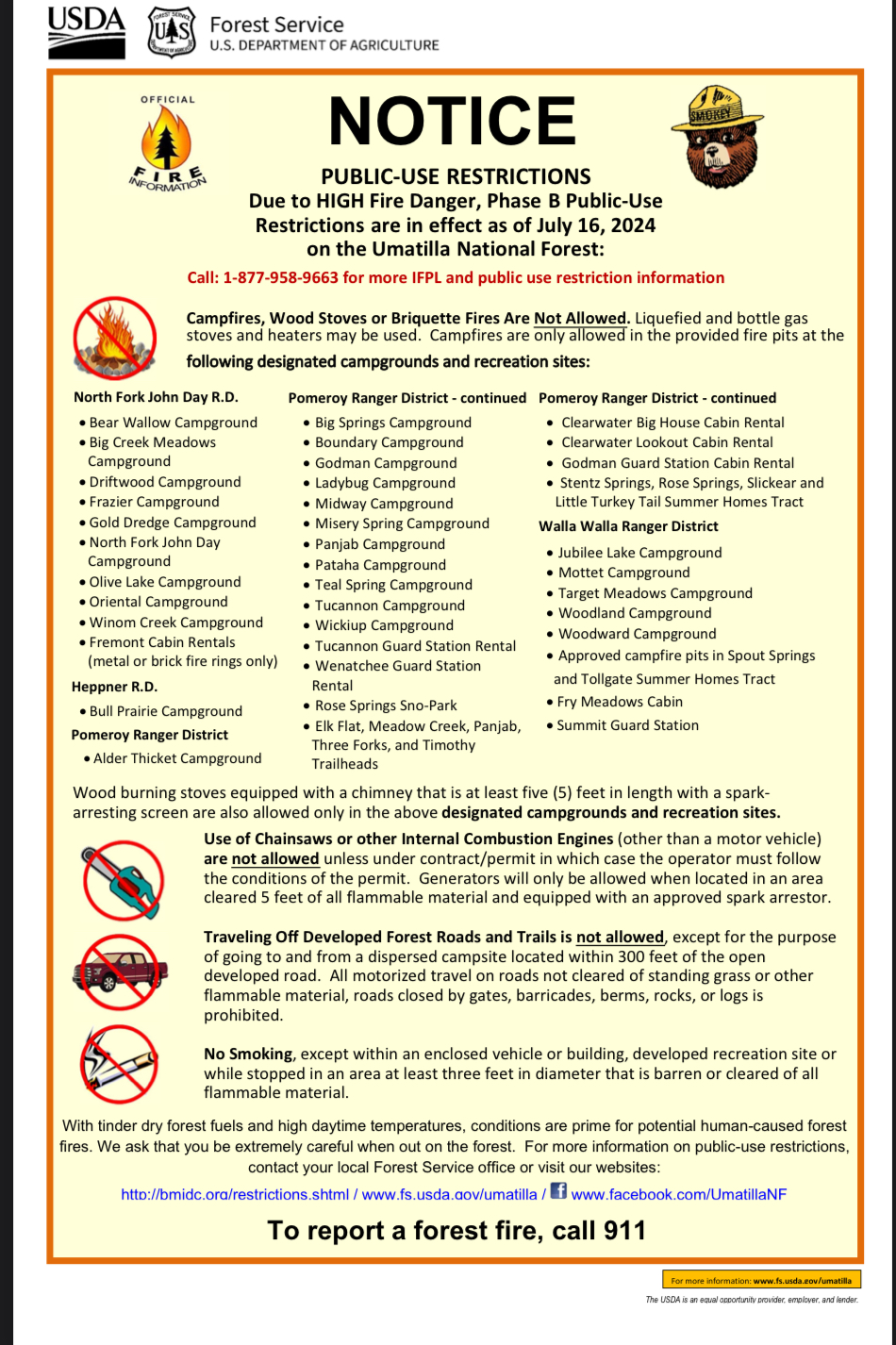
NOTICE
PUBLIC-USE RESTRICTIONS
Due to HIGH Fire Danger, Phase B Public-Use Restrictions are in effect as of July 16, 2024 on the Umatilla National Forest:
Call: 1-877-958-9663 for more IFPL and public use restriction information
Campfires, Wood Stoves or Briquette Fires Are Not Allowed. Liquefied and bottle gas stoves and heaters may be used. Campfires are only allowed in the provided fire pits at the following designated campgrounds and recreation sites:
Pomeroy Ranger District
Alder Thicket Campground
Big Springs Campground
Boundary Campground
Clearwater Big House Cabin Rental
Clearwater Lookout Cabin Rental
Godman Guard Station Cabin Rental
Godman Campground
Ladybug Campground
Midway Campground
Misery Spring Campground
Panjab Campground
Pataha Campground
Stentz Springs, Rose Springs, Slickear and Little Turkey Tail Summer Homes Tract
Teal Spring Campground
Tucannon Campground
Wickiup Campground
Tucannon Guard Station Rental
Wenatchee Guard Station Rental
Rose Springs Sno-Park
Elk Flat, Meadow Creek, Panjab, Three Forks, and Timothy Trailheads
North Fork John Day R.D.
Bear Wallow Campground
Big Creek MeadowsCampground
Driftwood Campground
Frazier Campground
Gold Dredge Campground
North Fork John DayCampground
Olive Lake Campground
Oriental Campground
Winom Creek Campground Fremont Cabin Rentals
(metal or brick fire rings only)
Heppner R.D.
Bull Prairie Campground
Walla Walla Ranger District
Jubilee Lake Campground
Mottet Campground
Target Meadows Campground
Woodland Campground
Woodward Campground
Approved campfire pits in Spout Springs and Tollgate Summer Homes Tract
Fry Meadows Cabin
Summit Guard Station
Wood burning stoves equipped with a chimney that is at least five (5) feet in length with a spark-arresting screen are also allowed only in the above designated campgrounds and recreation sites.
Use of Chainsaws or other Internal Combustion Engines (other than a motor vehicle) are not allowed unless under contract/permit in which case the operator must follow the conditions of the permit. Generators will only be allowed when located in an area cleared 5 feet of all flammable material and equipped with an approved spark arrestor.
Traveling Off Developed Forest Roads and Trails is not allowed, except for the purpose of going to and from a dispersed campsite located within 300 feet of the open developed road. All motorized travel on roads not cleared of standing grass or other flammable material, roads closed by gates, barricades, berms, rocks, or logs is prohibited.
No Smoking, except within an enclosed vehicle or building, developed recreation site or while stopped in an area at least three feet in diameter that is barren or cleared of all flammable material.
With tinder dry forest fuels and high daytime temperatures, conditions are prime for potential human-caused forest fires. We ask that you be extremely careful when out on the forest. For more information on public-use restrictions, contact your local Forest Service office or visit our websites:
http://bmidc.org/restrictions.shtml / www.fs.usda.gov/umatilla / www.facebook.com/UmatillaNF
To report a forest fire, call 911
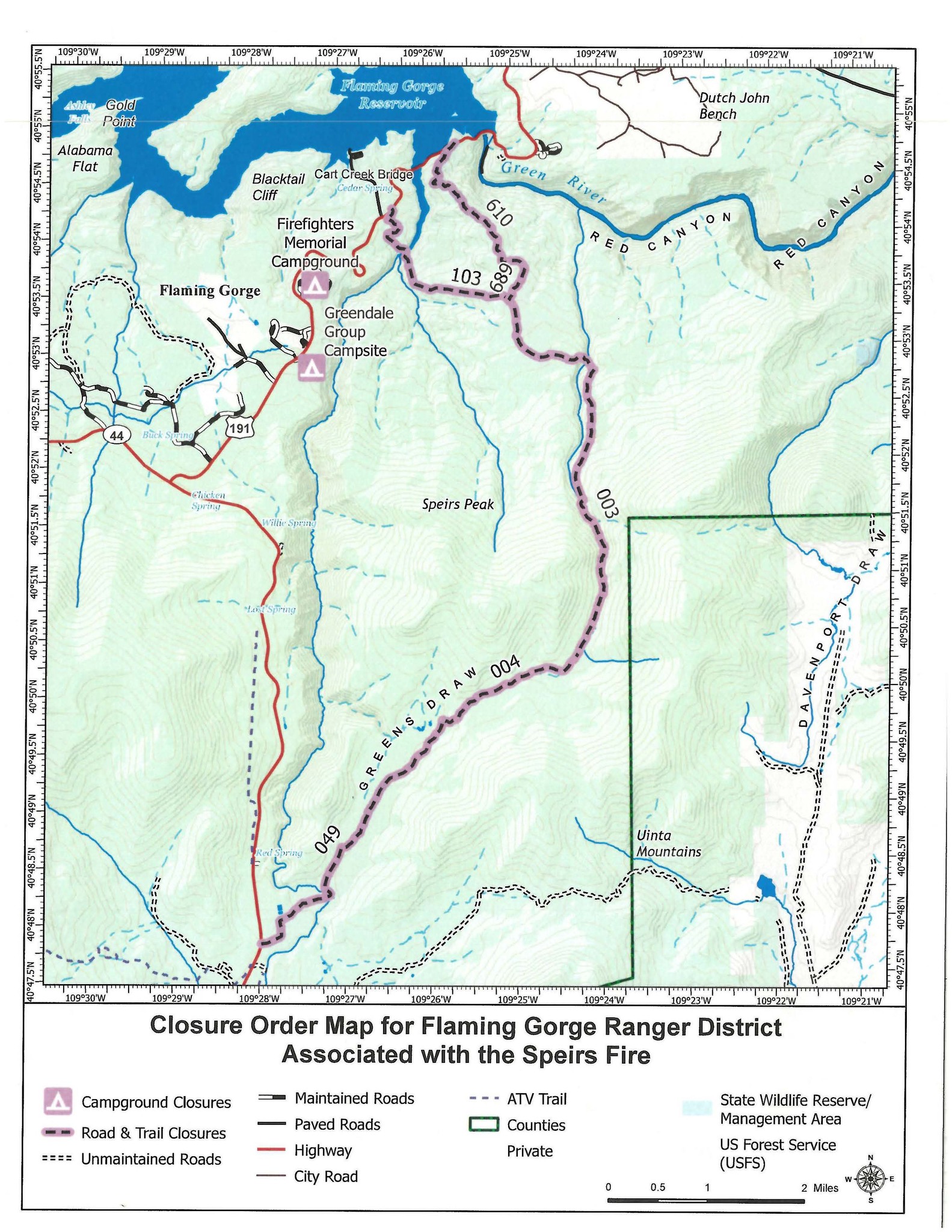
Temporary Closures Issued for Speirs Fire 07 16 2024
Related Incident: Speirs Fire
Publication Type: Closures
Dutch John, Utah, July 16, 2024 – A temporary closure order has been issued for the following campgrounds, roads and trails near the Speirs Fire:
• Firefighters Memorial Campground
• Greendale Group Campsite
• Forest Service Road (FSR) 610, FSR 689, Lowline trail FST103 its junction with the Pipe Creek Trail, FST 003. Forest Service trail 003 from beginning at junction with FST 103 to the junction of Forest Service trail 004, and Forest Service trail 004 to Greens Draw Road 049.
The closures are being issued as a precaution due to their location near the Speirs Fire. This will provide for public safety and provide future access for fire resources. Currently, fire activity remains light due to the precipitation received Monday. The closures are intended to prevent future concerns should fire activity increase.
There are currently no evacuations for the Speirs Fire. Other campgrounds, marinas, roads, trails, and developed recreation sites within the Flaming Gorge National Recreation Area remain open. This includes boating access to the Green River below Flaming Gorge Dam.
Lone Rock Fire Update July 16 2024 07 16 2024
Related Incident: Lone Rock Fire
Publication Type: News
LONE ROCK FIRE DAILY UPDATE July 16, 2024
Fire Information Line - 541-208-4369
www.centraloregonfire.org https://twitter.com/CentralORFire
Size: 64,860 acres
Location: 10 miles SE of Condon, Oregon
County: Gilliam
Start Date: July 13, 2024
Containment: 1%
Cause: Under Investigation
Total Personnel: 333
Lonerock, Oregon- The Lone Rock Fire began on July 13, and is being managed under a full suppression strategy. The Southern Area Gray Incident Management Team, led by Incident Commander Fulton Jeansonne, assumed command of the fire on Sunday, July 14, at 8:00 PM local time.
Yesterday's Activities - There was continued fire activity and growth on Monday and overnight. Fire personnel were actively engaged in suppression efforts as well as scout and identify possible fire containment lines. Helicopters, large air tankers, and single-engine air tankers dropped water and retardant to slow fire spread.
Today's Activities - Fire crews will continue to build on prior suppression efforts. Any flare ups and hot spots will be extinguished. Increased fire behavior is possible today with continued hot, dry, and windy conditions. Around the town of Lonerock, resources will build upon the progress from the previous operational periods. Fire crews will continue fire suppression repair activities, mop-up, and patrol of containment lines. Any flare ups and hot spots will be extinguished.
Weather -Sunny, with a high near 94. South wind 5-8 mph becoming northwest in the morning.
Level-3 Evacuations - GO NOW! Level-3 Evacuate immediately for the following areas:
Gillium County - From the community of Lonerock. An evacuation center is set up at memorial
hall in Condon. For more information on evacuations, visit Gilliam County Sheriffs Office Facebook page.
Morrow County - From the West County Line along Buttermilk Canyon to HWY 207, Mile Post 10 South of Hardman to the South Morrow County line. The Red Cross will be setting up a temporary shelter at the Heppner Elementary School. For more information on evacuations, visit: https://www.facebook.com/mcsoheppner
Level-2 Emergency Alert - GET SET! Level-2 Be set to evacuate at a moment's notice for the following areas:
From Hardman to the South Morrow County Line.
Smoke from the Lone Rock Fire continues, and maps and air quality information is always
available on https://fire.airnow.gov/. Please help firefighters by following all local regulations, found here: https://www.oregon.gov/odf/fire/pages/restrictions.aspx. Additional wildfire
prevention tips are available at www. keeporegongreen.org.
Settings - change map background and toggle additional layers
Filter - control incident types displayed on map.
Zoom to your location
Reset map zoom and position
Could not determine your location.
Show Legend
 Wildfire
 Prescribed Fire
 Burned Area
Response
Burned Area
Response Other
Other
Lone Rock Fire
Unit Information
Incident Contacts
Complex Incident Management Team shadowing local Type 3 team 07 16 2024
Related Incident: Speirs Fire
Publication Type: Announcement
Today, the Great Basin Complex Incident Management Team (CIMT) 3 was provided an in briefing from the Ashley National Forest and is currently shadowing the local Type 3 Incident Management Team. This "shadowing" will last the rest of the day and then Great Basin Team 3 will take over management of the Speirs Fire at 6:00 AM on Wednesday, July 17th.
Settings - change map background and toggle additional layers
Filter - control incident types displayed on map.
Zoom to your location
Reset map zoom and position
Could not determine your location.
Show Legend
- Wildfire
- Prescribed Fire
- Burned Area
Response
- Other