
Watch Fire Update Wednesday 07 17 2024
Related Incident: Watch Fire
Publication Type: News
Watch Fire: 2,162 acres
Start Date: July 10, 2024
Cause: Human Caused, Under Investigation
Fuels: Cottonwood, Brush, Understory
Containment: 100%
Resources: 148
Location: 7 Mile and Peridot Districts, San Carlos Reservation
100% Containment Achieved on the Watch Fire
Overview: Yesterday, the final piece of containment line was secured around the Watch Fire bringing the total containment to 100 percent. Firefighters will continue to patrol and monitor around structures and the fire perimeter today. Smoke may still be visible occasionally within the containment lines.
Weather: The Watch Fire is expected to see temperatures around 100-105 degrees in lower elevations with light west/southwest winds between 5-15 mph and gusts up to 25 mph. Storm cells will continue to develop erratically with a high probability of lightning which may cause new fire starts.
Safety: Additional fire personnel are available to respond to any new fires which may occur in the area. Please do not fly drones anywhere near the fire. Drones can endanger firefighting aircraft. If you fly, we can’t.
Smoke: Smoke-sensitive individuals and people with respiratory problems or heart disease are encouraged to take precautionary measures.
Reminder: Stage 1 Fire Restrictions remain in place on the San Carlos Apache Reservation. Due to extreme drought, increasing temperatures and no rain predicted soon, the potential of catastrophic wildfire remains high. This restriction is for the protection of public health, safety, property, and natural resources. No burn permits will be issued at this time. For more information call Fire Prevention (928) 475-2326 Ext: 352, 321 or (928) 961-0515 or email asteele@forestry.scatnsn.gov or wsteele@forestry.scatnsn.gov.
Evacuations: The following communities remain at “SET” (be alert) Status:
- Lower Seven Mile Wash,
- New Moonbase,
- Farmers Station,
- Downtown San Carlos, and
- Peridot Siding.
Residents are asked to avoid burned structures due to hazardous materials that may have long term health effects. For more information, call the San Carlos Apache Tribe Emergency Response Commission (TERC) at 928-475-2008 or visit the TERC or the San Carlos Police Department Facebook pages. See below.
Silver King Fire Daily Update July 17 2024 07 17 2024
Related Incident: Silver King Fire
Publication Type: News
**Silver King Fire Daily Update - July 17, 2024**
The fire perimeter has not grown significantly over the last several days, so the fire footprint has not significantly changed. On Tuesday five Hot Shot crews were strategically assigned to engage the fire in the steep and difficult terrain in the Deer Creek drainage, today there will be four crews to continue the effort. Good progress has been made securing the line on the fire’s edge from Beaver Creek to Bullion Canyon, firefighters continue to mop up, as well as monitor and patrol the line. To allow for public access on forest service roads after the fire, hazardous trees are being removed and the roads graded.
Night operations continue in the Bullion Canyon area to protect the Marysvale watershed and Miners Park historic area. The natural barriers on the west and southwest sides continue to minimize fire spread.
Firefighter safety is the number one priority on the Silver King Fire, and all fire incidents. Late afternoon thunder storms, producing lightning and strong erratic winds result in safety watchout situations for firefighters. Several times during this incident, resources have been removed from the line to help ensure their safety. Despite these challenges, no injuries have been reported, and firelines continue to hold.
Monsoonal moisture remains in the area which will result in continued chance of afternoon thunderstorms for the next few days. Wind speeds should be less than what has been experienced during the last few days. Temperatures are expected to be in the mid-80s over the lower elevations of the fire, and low relative humidities are around 17-25 percent.
Air quality for most areas around the fire has improved. For more smoke information go to https://www.wildlandfiresmoke.net/outlooks.
The Fishlake National Forest has issued a Forest Closure Order and Stage 1 Fire Restrictions that can be found here: https://www.fs.usda.gov/alerts/fishlake/alerts-notices. The Castle Rock Campground remains open to the public.
2024 SQF Lightning Daily Incident Update 07 17 2024
Related Incident: 2024 SQF Lightning
Publication Type: News
Acorn Fire: 5 acres - 80% containment
Packsaddle Fire: 47 acres - 50% containment
Long Fire: 888 acres - 0% containment
Trout Fire: 6,643 acres - 0% containment
Total Personnel: 251
Current Situation: Hot and dry conditions paired with afternoon winds fueled intense fire behavior and growth on both the Trout and Long Fires on Tuesday. Fuels in the area are critically dry and extremely receptive to burning. Smoke from the 2024 SQF Lightning Incident continues to impact the surrounding communities. Firefighters have made great progress on securing the Acorn and Packsaddle Fires and as these fires are moved into a patrol status, all crews and resources are being directed to the Trout and Long Fires.
Acorn Fire: After working over the past several days to ensure that control lines are mopped up and secure, the Acorn Fire has been placed in a patrol status. This means that a majority of the fire is considered contained and that a local crew will monitor the fire perimeter today to ensure that there is no threat of flare up or escape.
Packsaddle Fire: Activity on the Packsaddle Fire remained minimal on Tuesday with assigned crews actively mopping up hot spots and continuing to strengthen containment lines. The fire is 50% contained and firefighters will work through the day to hold and improve containment lines with the goal of significantly increasing containment by the end of shift.
Trout Fire: The Trout Fire remains active around its entire perimeter and showed significant fire growth yesterday. The fire moved east into Woodpecker Meadow and toward Smith Meadow. Firefighters started constructing control lines Tuesday along the Boone Meadow Road and will continue these efforts today with the priority of anchoring the fire’s western side. Crews have also been scouting and working on the northeast corner of the fire near the Bald Mountain lookout with the intention of holding the fire’s northern flank. Firefighters and crews will also be conducting fuels reduction and preparation work along the Sherman Pass Road throughout the shift in advance of the fire’s potential northern spread.
Long Fire: The Long Fire was added to the 2024 SQF Lightning Incident on July 16, 2024.It is currently burning in the Domeland Wilderness south of the Long Valley Campground and near Palome Creek and South Fork of the Kern River. On Tuesday, when elevated temperatures and increased winds arrived in the afternoon, the fire overcame the eastern retardant lines, spotted, and spread significantly to the east towards the Chimney Peak Wilderness. Several hotshot crews as well as aircraft will be working together to anchor the fire’s western edge, construct control lines along the flanks, and try to stop the fire’s forward progress to the east.
Weather: Warm and dry conditions are forecasted across the fire areas today. Increased southwest winds in the early afternoon will help lift the smoke inversion, but also improve conditions for fire activity. The warming and drying trend with critically low relative humidity is forecasted to continue into this weekend.
Forest Closures & Restrictions: Lands, roads, trails and recreation sites around the Trout, Long, and Packsaddle Fires are temporarily closed under Forest Order No. 0513-24-11. Fire restrictions are also in effect under Forest Order No. 0513-24-10. Both orders, along with accompanying appendices and maps, can be found on the Sequoia National Forest’s Forest Orders web page: tinyurl.com/2en2d36k.
Buckhorn Fire Area Closure 07 17 2024
Related Incident: Buckhorn Fire
Publication Type: Closures
There is an area closure in place around the Buckhorn Fire. Closures are being adjusted based on fire activity for public and firefighter safety. Please monitor the San Carlos Apache Tribe Facebook Page for updated information. (Link Below)
Graff Point Fire Update Wednesday 07 17 2024
Related Incident: Graff Point Fire
Publication Type: News
Cedar City, Utah– The Graff Point Fire remains at 544 acres and is now 47% contained. In total, 367 personnel are assigned to the incident.
Crews continue their full suppression efforts to contain the fire. Yesterday, they strengthened containment lines along the northern and southern flanks and constructed handlines along uncontained areas on the southeast and southwest flanks. Firefighters are using a hose lay on the east side to secure the fire line and extinguish hot spots. Aerial resources have supported ground crews with water drops to cool hot spots and retardant to slow the fire's spread. Similar firefighting efforts will continue today. Additionally, along S. Kanarra Mountain Road, chippers and masticators will be used to reduce fuels.
A community meeting was held last night at the Heritage Center Theatre in Cedar City, UT. Representatives from the Great Basin Complex Incident Management Team 6 and local agencies shared information on the status of the fire, the operational strategy, and the plan going forward. The speakers also spent time answering questions from the those in attendance and watching online. A recording can be found here: https://tinyurl.com/3a55uvdy
Despite recent precipitation, the fuels remain dry, resulting in some interior creeping and torching. The chance of isolated thunderstorms are expected to develop again today, and temperatures will be in the mid-80’s.
For information regarding evacuations, please contact the Iron County Sheriff. We kindly ask that you respect these measures and avoid the area. For more information, please visit : https://inciweb.wildfire.gov/incident-information/ututs-graff-point-fire or utahfireinfo.gov
For private landowners, information is available from the Utah DNR on reducing wildfire threats to homes and property. Homeowner Education | Utah DNR – FFSL (Forestry, Fire and State Lands)
Deadman Fire Daily Update 07 17 2024
Related Incident:
Publication Type: News
Video Update: https://fb.watch/tnZ0SrC31t/
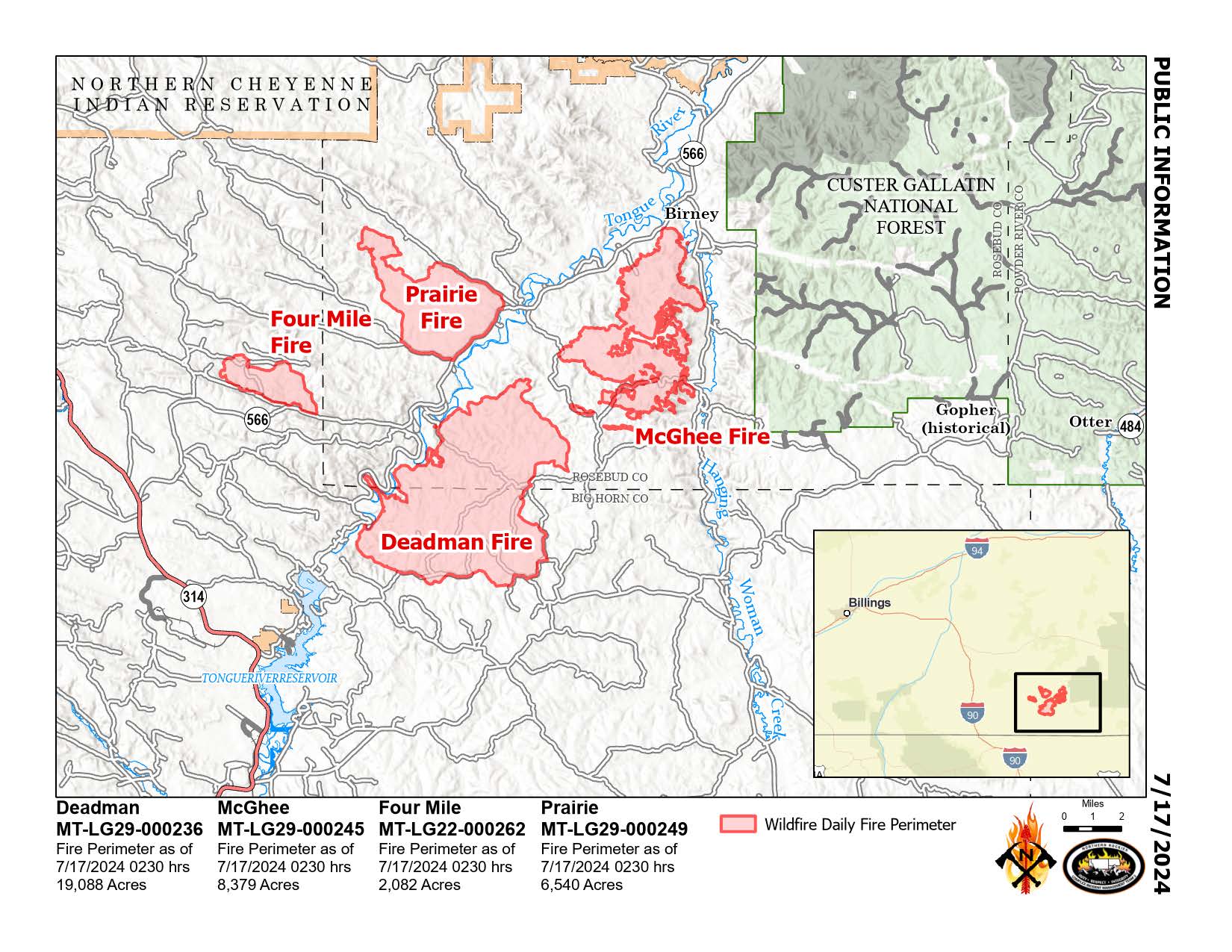
Deadman, McGhee, Prairie, and Four Mile Fires
Bureau of Land Management Montana-Dakotas State Office
Montana Department of Natural Resources and Conservation
Fire Information 406-924-3831 2024.Deadman@firenet.gov
https://inciweb.wildfire.gov/incident-information/mtmts-deadman-fire www.facebook.com/RosebudCountyDisasterAndEmergencyServices
Wednesday, July 17, 2024
Northern Rockies Team 3, Incident Commander Mike Behrens
Location: South of Birney, Montana and north of Tongue River Reservoir in Rosebud and Big Horn Counties
Start Date: 7/12 and 7/13/2024
Cause: Lightning
Size: Deadman: 19,088 McGhee: 8,379 Prairie: 6,540 Four Mile: 2,082
Completion/Containment: Deadman: 20% McGhee: 10% Prairie: 50% Four Mile: 1%
KEY MESSAGE: Firefighters conducted burnout operations on the McGhee and Deadman fires Tuesday. On the McGhee Fire, helicopters and air tankers assisted with water and retardant drops when heavy vegetation, wind, and terrain aligned to increase fire behavior in the afternoon and evening. The fire pushed south of Wall Creek Road. Two Hotshot crews and other resources worked overnight to conduct burnouts north of Lacey Gulch Road and west of Hanging Woman Creek to try to tie it into the northeastern edge of the Deadman Fire. On the west side of the Deadman Fire, a smokejumper module conducted burnout operations to bring the fire down into the Tongue River corridor where it can be secured. An Unmanned Aerial System (drone) was used overnight to continue with small burnout operations.
CURRENT STATUS: Crews will hold and secure the eastern McGhee fire lines today and continue with burnouts on the south and east as weather conditions allow. Fire managers will also determine how to tie lines together from the west side down into the south portion, avoiding the Battle Butte Area of Critical Environmental Concern as fire will be less detrimental to this area than suppression efforts. On Deadman, crews will continue to conduct small burnouts on the west side to bring the fire down to the river. On the Four Mile Fire, firefighters are cooling the remaining hot spots and patrolling the edges. The Prairie Fire is showing little heat and is being monitored.
WEATHER AND FIRE BEHAVIOR: Winds are predicted to have a north-easterly component today, which could help reduce fire spread to the east. Weather remains hot and dry today, with a slight chance of precipitation on Thursday. Active fire behavior and group torching is expected, especially as fire reaches stringers of timber and heavy pockets of older juniper trees.
CLOSURES AND SPECIAL MESSAGES: In Big Horn County, an evacuation warning is in place for residents from the intersection of Dale Creek Road and East Fork Canyon Road, east to the county line; from the intersection of Dale Creek Road and East Fork Canyon Road south to the intersection of Birney Road and Highway 314; from the intersection of Highway 314 and Birney Road east to the county line. In Rosebud County, an evacuation warning is in place for residents along the Tongue River Road from the Tongue River Bridge at Wall Creek to the southern Rosebud County line. Look for specific closure information and maps on the Rosebud and Big Horn County Sheriff Facebook pages.
An evacuation warning means people should be aware of and monitor the situation closely, being prepared to evacuate if needed as the status could change quickly.
Horse Gulch Fire Update 07 17 2024
Related Incident: Horse Gulch Fire
Publication Type: News
Start Date & Location: July 9, 2024, 5 miles south of York, MT
Cause: Human, under investigation Size: 14,250 acres Containment: 23%
CURRENT STATUS AND PLANNED ACTIONS
Yesterday on the north flank of the fire, crews conducted tactical firing operations in the afternoon from the established control line to the fire's edge, which widened fire lines and generated an expected smoke plume. Crews also successfully established dozer lines around a spot fire situated outside of the northern perimeter of the fire. Concerns remain on the east flank, just south of the Cave Gulch Fire burn in 2000, where the fuel loads are more susceptible to rapid fire spread. To address this, aerial resources dropped retardant along the fire perimeter to prevent fire spread. Crews also responded to and extinguished a new ¼ acre spot fire near Hellgate Gulch Road. To the west, crews held and improved fire line along Jimtown Road northwards to the 4136 Road.
Overnight, crews on the northern flank continued tactical firing operations from established dozer lines to the fire’s edge, reducing combustible materials to strengthen fire lines.
Today, the primary mission is to hold control lines where the firing operations occurred yesterday and last night. On the south flank of the fire, crews will continue improving, mopping up, and cold trailing control lines to extinguish residual heat sources. With active fire behavior, Magpie Gulch remains a primary area of focus, with suppression efforts aimed at reinforcing control lines to halt fire spread.
The Structure Protection Group will continue to patrol and monitor structures throughout the fire area and assess the need for fuel mitigation around structures.
WEATHER AND FIRE BEHAVIOR
A chance of thunderstorms are forecast, with the possibility of gusty winds, lightning, and light rain, but without beneficial impact to the fire. Temperatures will be in the low 90's with humidity in the teens. SE winds with gusts up to 20mph may cause spotting where slope and fuels align.
EVACUATIONS AND CLOSURES
Evacuations (UPDATED): Effective 7/15/24, all evacuation orders transitioned to evacuation warnings,
allowing residents of homes and RVs back into their properties. Under evacuation warning, residents should be prepared to leave if conditions change. Sheriff - Lewis & Clark County (lccountymt.gov)
Road Closure: Canyon Ferry Road remains closed to non-residents from Canyon Ferry Village to the Broadwa-ter County line.
Campground Closure: Campground closures include Hellgate, Court Sheriff, Chinamen’s Gulch, and Riverside.
Forest Closure: The Helena-Lewis and Clark National Forest updated their forest closure. It can be found at Helena-Lewis and Clark National Forest - Home (usda.gov)
BLM Closure: The Butte Field Office has issued a closure on BLM lands near the fire area. https://inciweb.wildfire.gov/incident-publication/mthlf-horse-gulch-fire/signed-blm-area-closure-07-14-2024
Buckhorn Fire Update Wednesday 07 17 2024
Related Incident: Buckhorn Fire
Publication Type: News
Buckhorn Fire: 599 acres
Start Date: July 10, 2024
Cause: Suspected lightning
Fuels: Timber, Brush, Understory
Containment: 22%
Resources: 130
Location: Maylay Gap Area, San Carlos Reservation
22% Containment Achieved on the Buckhorn Fire
Overview: Yesterday, crews on the Buckhorn Fire completed removing vegetation along the 2034 Road on the southern end of the fire and cleared about three-quarters of the brush along the 2030 Road on the eastern side of the fire. A dozer was moved into position to begin work today. A defensive burning operation was performed, resulting in 22 percent containment. Today, additional resources, including the Geronimo Interagency Hot Shot Crew, will work to complete clearing the 2030 Road. Geronimo Hot Shots will begin scouting along the ridgetops to locate accessible areas to continue building containment lines to keep the fire as small as possible while protecting timber assets.
Weather: Yesterday, storms continued to build erratically around the Buckhorn Fire. The storm cells brought lightning but no measurable rain. Today will bring more storms with little likelihood of precipitation. Temperatures will remain between 80-85 degrees with light west/northwest winds. The storms may also bring outflow winds from the south.
Safety: Please do not fly drones anywhere near the fire. Drones may endanger firefighting aircraft. If you fly, we can’t.
Reminder: Stage 1 Fire Restrictions remain in place on the San Carlos Apache Reservation. Due to extreme drought, increasing temperatures and no rain predicted soon, the potential of catastrophic wildfire remains high. This restriction is for the protection of public health, safety, property, and natural resources. No burn permits will be issued at this time. For more information call Fire Prevention (928) 475-2326 Ext: 352, 321 or (928) 961-0515 or email asteele@forestry.scat-nsn.gov or wsteele@forestry.scatnsn.gov.
Closures: There is an area closure in place around the Buckhorn Fire. Closures are being adjusted based on fire activity for public and firefighter safety. Please monitor the San Carlos Apache Tribe Facebook Page for updated information. (Link Below)
Smoke: Smoke-sensitive individuals and people with respiratory problems or heart disease are encouraged to take precautionary measures.
Ko’ doo bena golde’ da
Salt Creek Fire Daily Update 07 17 2024
Related Incident: Salt Creek
Publication Type: News
ODF Team 1 prepares to transition Salt Creek Fire back to local districts
EAGLE POINT, Ore. – The Oregon Department of Forestry (ODF) Incident Management Team 1 remains engaged on the Salt Creek Fire today, but a transition back to the local districts is now in the works. The fire is 100% lined at 4,102 acres and is 84% contained this morning. Today will be the final day shift for IMT personnel and as of 7:00 a.m. Thursday morning, the team will disengage and return command of the fire to a local Type 3 team.
Even during this transition, work continues on the fire and mop-up remains the main focus for resources on the line. The increasing containment illustrates the amount of work that firefighters have been able to complete in the last couple days. Repair work also continues across the fire as firefighters put in water bars and rehab other areas that may have been affected by the firefighting efforts.
Just under 700 personnel remain assigned to the fire for Wednesday’s day and night shift, including 25 crews, 20 engines, 12 water tenders, five bulldozers and seven helicopters of various types. As resources continue to work today and following the transition light smoke may be visible within the interior of the fire, however resources are still engaged.
Level 1, “BE READY,” evacuation notices remain in effect for zones JAC-316, JAC-317 and JAC-325-A. Any changes to evacuations will made by the Jackson County Sheriff's Office and Emergency Management. Learn more about evacuations at: https://protect.genasys.com/
BLM Medford District has temporarily closed BLM-managed lands in the area for safety. For more info go to: https://www.blm.gov/orwafire
The Salt Creek Fire is located 10 miles east of Eagle Point and was first reported Sunday, July 7, just after 4 p.m. The cause is under investigation.
This will be the final update from Team 1. Further updates will be available from local agencies:
- The ODF Southwest Oregon District: https://swofire.com/
- The RRSNF Alerts and Notices page www.fs.usda.gov/alerts/rogue-siskiyou/alerts-notices and website homepage www.fs.usda.gov/rogue-siskiyou
- The BLM OR/WA Fire Management Page: www.blm.gov/orwafire
Vista Fire Morning Update 07 17 2024
Related Incident: Vista Fire
Publication Type: News
Size: 2936 acres
Containment: 67%
Total Personnel: 445
Structures Threatened: 416
Start Date & Time: 7-7-24 9:51
Cause: Under Investigation
Location: Southside of Lytle Creek
Yesterday, firefighters continued patrol and mop-up operations and expanded containment lines along the southern flank in the Cucamonga Wilderness. Firefighters have pivoted to suppression repair activities and will be consolidating materials and equipment for removal. Fire behavior remained minimal with no growth. Crews are remaining vigilant and prepared should new starts occur. Containment increased to 67 percent.
“Our firefighters’ hard work and professionalism is showing. The plan today is to continue that hard work and keep an eye out for any new starts,” said Scott Cones, Plan Operations Chief.
The Forest Closure on the San Bernardino and Angeles National Forest remains in effect to ensure the safety of firefighters and the public. The public is prohibited from using roads, trails, and recreation areas in the Vista Fire area and should not enter the forest on Lytle Creek Road.
AIR QUALITY:
Visit AirNow.gov for information and actions you can take to protect yourself and loved ones.
ROAD CLOSURES:
Lytle Creek Road is closed to the general public including all recreation areas north of Glen Helen Parkway.
EVACUATIONS:
None.
Note: In an effort to quickly communicate information on impending dangers, the San Bernardino County Sheriff Department and San Bernardino County Fire Department send high-speed mass notifications via telephone and text messages. This system is known as the Telephone Emergency Notification System (TENS). To learn more about this service, visit the website for more information: https://sbcfire.org/alertwarning/.
CLOSURES:
Closure order in effect on the San Bernardino National Forest and the Angeles National Forest. Several roads, campgrounds, picnic areas, trailheads, and dispersed recreation areas are closed to the public to provide for firefighters, community and public safety. Recreation activities are prohibited within the closure area. More information about the closure order is available on the national forest websites at https://www.fs.usda.gov/alerts/sbnf/alerts-notices and https://www.fs.usda.gov/alerts/angeles/alerts-notices.
FIRE RESTRICTIONS:
The San Bernardino National Forest has implemented increased fire restrictions. Campfires are restricted to those developed areas listed in the Forest Order.