
Horse Gulch Smoke Outlook 07 18 2024
Related Incident: Horse Gulch Fire
Publication Type: News
Special Statement
A Few Storms Possible with Lightning and Gusty Winds
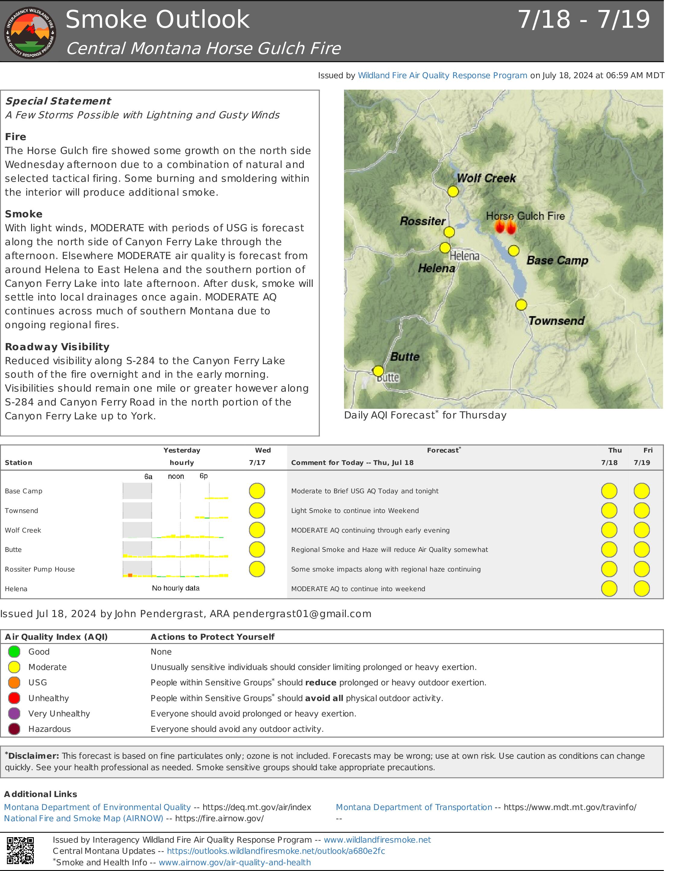
Fire
The Horse Gulch fire showed some growth on the north side Wednesday afternoon due to a combination of natural and selected tactical firing. Some burning and smoldering within the interior will produce additional smoke.
Smoke
With light winds, MODERATE with periods of USG is forecast along the north side of Canyon Ferry Lake through the afternoon. Elsewhere MODERATE air quality is forecast from around Helena to East Helena and the southern portion of Canyon Ferry Lake into late afternoon. After dusk, smoke will settle into local drainages once again. MODERATE AQ continues across much of southern Montana due to ongoing regional fires.
Roadway Visibility
Reduced visibility along S-284 to the Canyon Ferry Lake south of the fire overnight and in the early morning. Visibilities should remain one mile or greater however along S-284 and Canyon Ferry Road in the north portion of the Canyon Ferry Lake up to York.
Pioneer Fire Daily Update 07 18 2024
Related Incident:
Publication Type: News
Pioneer Fire Update for July 18, 2024
Incident Commander Jeff Dimke
Complex Incident Management Team Northwest 12
541-861-5808, staffed 8 a.m. to 8 p.m. 2024.pioneer@firenet.gov
Quick Facts
Size: 25,688
Start Date: June 8, 2024
Location: 31 miles NW of Chelan, WA
Containment: 14%
Personnel: 783
Cause: Human-caused, under investigation
Resources Assigned: 14 crews, 8 helicopters, 21 engines, 24 water tenders, 19 heavy equipment
There will be a Stehekin community meeting tonight at 6 PM at the Golden West Visitor Center.
The Pioneer Fire is burning within a mountainous and remote area on the Okanogan-Wenatchee National Forest near Lake Chelan. Firefighters are using a full suppression response in the Lake Chelan-Sawtooth Wilderness to protect values at risk, life, and property, with firefighter and public safety as the primary objective. The communities of Chelan, Manson, and Stehekin are open and continue to welcome visitors.
Operations: Firefighters completed structural assessments near Stehekin as well as expanding and strengthening handline and hose lays near the Stehekin Valley Ranch. With the extensive preparation around town nearly finalized, firefighters and fire engines are prepared to protect the community of Stehekin in the event fire approaches. Heavy helicopters will be working water bucket drops today, limiting fire spread across Hunts Creek where firefighters are working on the ground to protect structures and infrastructure.
The Uncrewed Aerial System crew at Graham Harbor will continue to closely watch the Lone Fir drainage, using an infrared camera to identify any residual heat sources in the timber fingers around Canoe and Lone Fir Creeks that could reignite. Firefighters with heavy equipment are making good progress improving the dozer line southward from Parrish Peak toward Cooper Corral Spring. Resources from the Pioneer Fire continue to be available to assist with initial attack fires in the area.
Safety and Closures: The National Park Service-North Cascades has expanded their list of closures: https://www.nps.gov/noca/planyourvisit/fire-closures.htm. The Okanogan-Wenatchee National Forest has a closure order in place for much of the fire area: https://bit.ly/PioneerClosure. There is a Temporary Flight Restriction (TFR) in place over the fire: https://tfr.faa.gov/save_pages/detail_4_6779.html. Drone activity is prohibited under the TFR, as helicopters cannot fly with unauthorized drones present.
Evacuations: Level 1, 2 and 3 evacuation levels remain in effect around the Pioneer Fire. Please visit https://t.ly/QoH9w for more information.
Weather and Smoke: A heat advisory remains in effect with today having clear skies, increased temperatures and continuing low relative humidity. The air quality up lake will be Unhealthy-to-Very Unhealthy for Sensitive Groups today, especially in the morning before clearing occurs. The air quality outlook can be found at: https://bit.ly/PioneerFireSmoke. Learn more about smoke at http://wasmoke.blogspot.com/. The fire marshal issued fire danger ratings and restrictions: https://t.ly/WLBds
Graff Point Fire Update Thursday 07 18 2024
Related Incident: Graff Point Fire
Publication Type: News
Cedar City, Utah – The Graff Point Fire remains at 544 acres and is now 57% contained. In total, 383 personnel are assigned to the incident.
Overall minimal fire behavior has been observed with smoldering and creeping in ground vegetation. Crews will continue to mop up the fires edge where needed and monitor for heat. Yesterday, crews strengthened containment lines along the northwestern flanks down to S. Kanarra Mountain Road. A spot fire off the southwestern flank has been contained. An infrared flight picked up some heat south of the fire near Middleton Rd, firefighters have since put in a hose lay and wetted down the area. Chippers and masticators will continue to be used to reduce fuels west of the fire perimeter along S. Kanarra Mountain Road and near the south boundary of the fire.
Afternoon showers and thunderstorms are expected to develop off of higher terrain. Other than a brief heavy rainfall, the primary threat will be gusty outflow winds and cloud to ground lightning. Temperatures will not change much with highs in the mid to upper 80s and relative humidity close to 20 percent in the afternoon.
The closure at the intersection of Tipple Road and Shirts Canyon, will be open 9 AM to 6 PM for Recreation Access to Pyramid Ridge Campground.
For information regarding evacuations, please contact the Iron County Sheriff. We kindly ask that you respect these measures and avoid the area. For more information, please visit: https://inciweb.wildfire.gov/incident-information/ututs-graff-point-fire or https://utahfireinfo.gov
For private landowners, information is available from the Utah DNR on reducing wildfire threats to homes and property. Homeowner Education | Utah DNR – FFSL (Forestry, Fire and State Lands)
Silver King Fire Daily Update July 18 2024 07 18 2024
Related Incident: Silver King Fire
Publication Type: News
**Silver King Fire Daily Update - July 18, 2024**
Community Meeting Tonight in Marysvale at 7:00 P.M.
The fruits of the hard work by firefighters were reaped today with the large increase in containment. The northwest portion of the fire is contained eastward to the top of Deer Creek, and crews will continue to mop-up and secure the line. Hot Shot crews will continue to construct line along the fires edge and reduce ladder fuels along the road in the Deer Creek drainage. They will also be constructing fireline from Deer Creek to Indian Hollow. Hand crew and engines will secure and mop-up hand and dozer lines from the southeast flank at Bullion Creek to the 2002 Cottonwood fire scar. Because the fire perimeter is stable, tonight will be the last night shift.
Because of the significant progress made by firefighters, downsizing of the incident has begun and crews, engines, and overhead are being released as appropriate. Hose lines and equipment are being removed from secure areas of the fire. A Suppression Repair Plan has been approved to address the impacts from fire operations such as ground disturbance and damage to infrastructure.
Fishlake National Forest has requested a Burned Area Emergency Response (BAER) team, which is enroute. The BAER team will be used to identify and manage potential risks to resources and reduce these threats to life, property, and critical natural or cultural resources within the burn area.
The chance of afternoon thunderstorms, including heavy showers continues. Wind speeds should be less than what has been experienced during the last few days. Temperatures are expected to be in the mid-80s over the lower elevations of the fire, and low relative humidities are around 30 percent in the fire area.
Air quality for most areas around the fire has improved. For more smoke information go to https://www.wildlandfiresmoke.net/outlooks.
The Fishlake National Forest has issued a Forest Closure Order and Stage 1 Fire Restrictions that can be found here: https://www.fs.usda.gov/alerts/fishlake/alerts-notices. The Castle Rock Campground remains open to the public.
Texas Fire Current as of 830 AM PT 07 18 2024
Related Incident: Texas Fire
Publication Type: News
July 18, 2024, 8:30 AM PT
Information Line: 208-901-7295 Email:2024.texas@firenet.gov
Inciweb: https://inciweb.wildfire.gov/incident-information/idids-texas-fire
Date of Origin: Monday, July 15, 2024, approx. 4:00 PM PT
Location: East of Kendrick, Idaho
Size: 1,543 acres Containment: 0% Personal: 150
Northern Rockies Incident Management Team 8 assumed command of the Texas Fire at 6:00 AM on July 18th.
Current Situation:
Yesterday, crews and heavy equipment constructed a combination of direct and indirect fire line around the fire perimeter, including the spot east of the main fire. Fireline construction has been completed with dozers, chainsaws, and handline. Early in the day, aviation resources aided fire suppression efforts near the intersection of Texas Ridge Road and Cedar Ridge Road as well as the northern-end of the fire. Later in the day, aviation focus shifted to the eastern spot. Engines patrolled the fire area overnight.
Today, firefighters will reinforce fireline by installing hose lays on the edge of the fire. Crews and heavy equipment will continue to reinforce constructed fireline by mitigating snags and rolling material and working directly along the fire’s edge where possible. Additional crews and equipment are expected to arrive today.
Weather forecast shows increased sun exposure to the fire today, with temperatures in the low 100s and relative humidity in the low teens. Winds will be light and mostly terrain driven. With increased hot and dry weather conditions, the likelihood for fire progression upslope and single to group tree torching is likely.
Evacuation Statuses:
As per the Latah County Sheriff's Department, the following are current evacuation status:
- Level 3 Evacuations:
- Cedar Ridge from Highway 3 to Linden Rd.
- Linden Rd. to S Park Rd.
- Texas Ridge Rd and East Rd. to Sundstrom Rd.
- Level 2 Evacuations:
- Texas Ridge and Sundstrom Rd to Highway 3
- Cedar Ridge Rd. at Linden Rd. to Three Bear Rd.
- All houses west of 1210 Cedar Ridge Rd.
- Level 1 Evacuation:
- Any houses 2 miles outside of the listed Level 2 evacuation locations.
As per the Nez Perce County Sheriff's Department, the following areas should be prepared for evacuations:
- Residents who live on and to the north of Southwick Road should be prepared in case of a mandatory evacuation. This area includes Brothers Ln, Koepp Rd, North Rd, Wendt Rd, and Lohman Rd.
Current Closure Orders:
- P1 and Texas Ridge remain closed at this time.
- For those with livestock, Lewiston Roundup is offering space for those impacted by the fire.
Vista Fire Morning Update 07 18 2024
Related Incident: Vista Fire
Publication Type: News
INCIDENT MORNING UPDATE
Date: 7-18-2024 Time: 9:00 am
Size: 2936 acres Start Date & Time: 7-7-24 9:51 am
Containment: 79% Cause: Under Investigation
Total Personnel: 396 Location: Southside of Lytle Creek
Structures Threatened: 416
Unified Command Agencies: California Incident Management Team 15, San Bernardino County Fire Dept.
The Forest Service has an area closure in effect on the San Bernardino and the Angeles National Forests. The public is prohibited from recreating in the fire area and should not enter the Forest on Lytle Creek Road. The closure is in effect to protect life and safety of firefighter personnel, residents and visitors.
AIR QUALITY:
Visit AirNow.gov for information and actions you can take to protect yourself and loved ones.
ROAD CLOSURES:
Lytle Creek Road is closed to the general public including all recreation areas north of Glen Helen Parkway.
EVACUATIONS:
None.
Note: In an effort to quickly communicate information on impending dangers, the San Bernardino County Sheriff Department and San Bernardino County Fire Department send high-speed mass notifications via telephone and text messages. This system is known as the Telephone Emergency Notification System (TENS). To learn more about this service, visit the website for more information: https://sbcfire.org/alertwarning/.
CLOSURES:
Closure order in effect on the San Bernardino National Forest and the Angeles National Forest. Several roads, campgrounds, picnic areas, trailheads, and dispersed recreation areas are closed to the public to provide for firefighter, community and public safety. Recreation activities are prohibited within the closure area. More information about the closure order is available on the national forest websites at https://www.fs.usda.gov/alerts/sbnf/alerts-notices and https://www.fs.usda.gov/alerts/angeles/alerts-notices.
FIRE RESTRICTIONS:
The San Bernardino National Forest has implemented increased fire restrictions. Campfires are restricted to those developed areas listed in the Forest Order.
###
2024 SQF Lightning Daily Incident Update 07 18 2024
Related Incident: 2024 SQF Lightning
Publication Type: News
Acorn Fire: 5 acres - 95% containment
Packsaddle Fire: 47 acres - 95% containment
Long Fire: 4,069 acres - 0% containment
Trout Fire: 8,721 acres - 0% containment
Total Personnel: 390
Current Situation: The Bureau of Land Management is now a cooperating agency with lands under their jurisdiction directly impacted. Another management change is the addition of a second fire camp located at Troy Meadow. This change will accommodate the increased resources fighting the Trout Fire and decrease daily travel times. The Long Fire resources will continue to utilize Camp 9 in the Kern River Valley. Firefighters have made great progress on securing the Acorn and Packsaddle Fires and each will remain in patrol status until full containment has been reached. Much of the resources from these fires are being redirected to the Trout Fire and Long Fire.
Acorn Fire and Packsaddle Fire: The Acorn Fire and Packsaddle Fire remain in a patrol status after days of mopping up and securing control lines. Crews will monitor the fire perimeter ensuring there is no threat of flare-up or escape.
Trout Fire: Fire behavior was low to moderate Wednesday and allowed for more direct line construction on the western side, along Boone Meadow Road. This resulted in reduced perimeter growth compared to previous days. Prevailing westerly winds and topography continue the trend of pushing the fire east. As direct line construction continues south along the western side, crews will look for opportunities to build control lines on the southern perimeter near Machine Creek. Crews continue to reinforce Sherman Pass Road, while also looking for opportunities of engagement closer to the fire’s edge. Aircraft are assisting in directing the fire towards the wilderness area where natural barriers can be utilized.
Long Fire: The Long Fire, burning in the Domeland Wilderness south of the Trout Fire, remains a high priority. Elevated temperatures and increased winds have pushed the fire east into the Chimney Peak Wilderness. Multiple hotshot crews have been shuttled via helicopter to the fire area. They are working to anchor the fire and build control lines.
Weather: Thursday will benefit from cloud and smoke shading over the fires due to an inversion layer over the area. This will cause temperatures to remain lower and relative humidity to rise. While the early part of the day will see weather that improves firefighters’ ability to fight fire, the afternoon is expected to make conditions more challenging once the inversion lifts. Thunderstorms are forecasted to flow through the area of the fires, bringing with it gusty and erratic winds. The warming and drying trend with critically low relative humidity is forecasted to return for the weekend.
Forest Closures & Restrictions: Lands, roads, trails and recreation sites around the Trout, Long, and Packsaddle Fires are temporarily closed under Forest Order No. 0513-24-12. Fire restrictions are also in effect under Forest Order No. 0513-24-10. Both orders, along with accompanying appendices and maps, can be found on the Sequoia National Forest’s Forest Orders web page: tinyurl.com/2en2d36k.
Black Fire Daily Update 07 18 2024
Related Incident: Black Fire
Publication Type: News
Acres: 11,162
Start Date: July 11, 2024
Location: South of Roosevelt Lake on the edge of the Superstition Wilderness
Cause: Lightning
Personnel: 348
Fuels: Tall Grass and Brush
Containment: 40%
Resources: 7 Crews | 4 Engines | 7 Helicopters | 3 Bulldozers | 6 Water Tenders
Highlights: Fire crews with the assistance of heavy equipment and aircraft have made significant progress in securing the fires edge just south of the Tonto National Monument; south and east just past Forest Road 449 to the boundary of the Superstition Wilderness.
Southwest Incident Team 3 will host a virtual public meeting to share information regarding the Black Fire on Friday, July 19 at 7:00. The meeting will be available to be viewed live on Facebook @TontoNationalForest.
Operations: Crews along with heavy equipment, where feasible, continue to secure the fires edge outside of the Superstition Wilderness. Smoldering and creeping fire behavior is expected to continue in the interior of the fire; as weather conditions are expected to be both hot and windy. The Black Fire was active Wednesday evening as thunderstorms with outflow and gusty erratic winds burned through Pinyon Juniper in the Cottonwood Canyon. Night crews monitored the fire’s activity in the wilderness as they patrolled the eastern edge of the fire. Today, crews will continue direct attack on the fire’s perimeter with ground and aerial resources, mainly on the northwest and southeast edge of the fire. Structure protection efforts continue south of State Route 188 at Quail Run, Spring Creek Ranch and residences.
Weather: Hot and dry conditions persist across the area with afternoon highs ranging from 100 to 105 degrees with afternoon relative humidity dropping to around 15-20 percent. There will be a slight chance of thunderstorms late this afternoon and early evening, but the main concern will be gusty outflow winds up to 30 mph that could impact the fire. Mostly clear skies overnight with mainly drainage winds of 2-5 mph. Humidity recoveries expected to be around 35-40 percent.
Smoke: There is moderate to heavy smoke present from the Black Fire as well as other fires in the area. Individuals who are sensitive to smoke or have conditions aggravated by smoke are encouraged to take precautionary measures. An interactive smoke map at https://fire.airnow.gov/ allows you to zoom into your area to see the latest smoke conditions.
Closures: The Tonto National Forest has issued a closure for land surrounding the Black Fire. 03-12-00-24-31_Black Fire_Closure_Order. Additionally, the Tonto National Monument is closed. National Park Service Alerts.
Evacuations: For current evacuation information please call Gila County Emergency Management at 928-910-4009 EXT 1 or visit the Gila County Government Facebook page at - https://www.facebook.com/gilacountygovernment/
Safety: The health and safety of firefighters and the public are always the highest priority. Please avoid the area while crews conduct fire suppression operations. Citizens are urged to sign up for the Gila and Maricopa County Emergency Notification System. To learn more about the Arizona Emergency Information Network visit: https://ein.az.gov/ready-set-go.
Cow Valley Fire Update 07 18 2024
Related Incident: Cow Valley Fire
Publication Type: News
Cow Valley Fire Update for Thursday, July 18, 2024
541-208-4371, staffed 7a.m. to 7 p.m. MDT
Start date: July 11, 2024
Location: 9 miles east of Ironside, OR
Total personnel: 378
Fire size: 133,408 acres
Cause: Human caused, under investigation
Containment: 77%
Vale, OR— Yesterday, thunderstorms occurred over and near the Cow Valley Fire area. No growth was detected, and fire activity has minimized significantly due to successful strategic firefighting operations. Firefighters continued suppression efforts connecting fire lines and extinguishing hot spots. Some Cow Valley resources aided in finding and suppressing new starts from lightning. Firefighters were able to douse one strike area with 1400 gallons of water and are confident it will not grow.
Today, at 6am, Northwest Team 6 took command of the lightning caused Durkee Fire. It is estimated to be about 3,000 acres, located in Baker County south of the town of Durkee, West of Cottonwood Gulch near Burnt River. Surplus resources from the Cow Valley Fire are being used to help assess and suppress the Durkee fire.
COW VALLEY FIRE: Firefighters working on the Cow Valley are continuing to patrol and find pockets of heat to extinguish. No fire spread is expected, and fire behavior is characterized as smoldering.
BONITA FIRE: The Bonita Fire is 2,727 acres and 90% contained. Minimal fire behavior has been observed due to suppression efforts, containment features and fuel consumption.
WEATHER AND SMOKE: It will be hot and dry today with temperatures ranging between 99-105 and low humidity around 10%. Winds will be north, northwest 5-9 MPH. The current smoke information and the air quality index, visit airnow.gov.
EVACUATIONS AND CLOSURES: All evacuation order related to the Cow Valley Fire have been lifted. Check below for updates or on the Malheur County Sheriff’s Office Facebook page. The Baker County Sheriff’s Office has issued evacuations for the area around Durkee Fire. Visit the Baker County Sheriff’s Office Facebook page for more information. Baker County Sheriff's Office has closed Burnt River Canyon road to non-local, non-emergency traffic due to the Durkee Fire.
BURN BAN: A burn ban is currently in effect for all of Malheur County, including all BLM lands. For more information, visit https://www.malheurco.org/category/public-notices/.
Ridge Fire Daily Operational Video 07 18 2024
Related Incident:
Publication Type: Announcement
Operations Video