
Deadman Fire Daily Update 07 18 2024
Related Incident:
Publication Type: News
Video Update: https://fb.watch/to-u2m51pN/
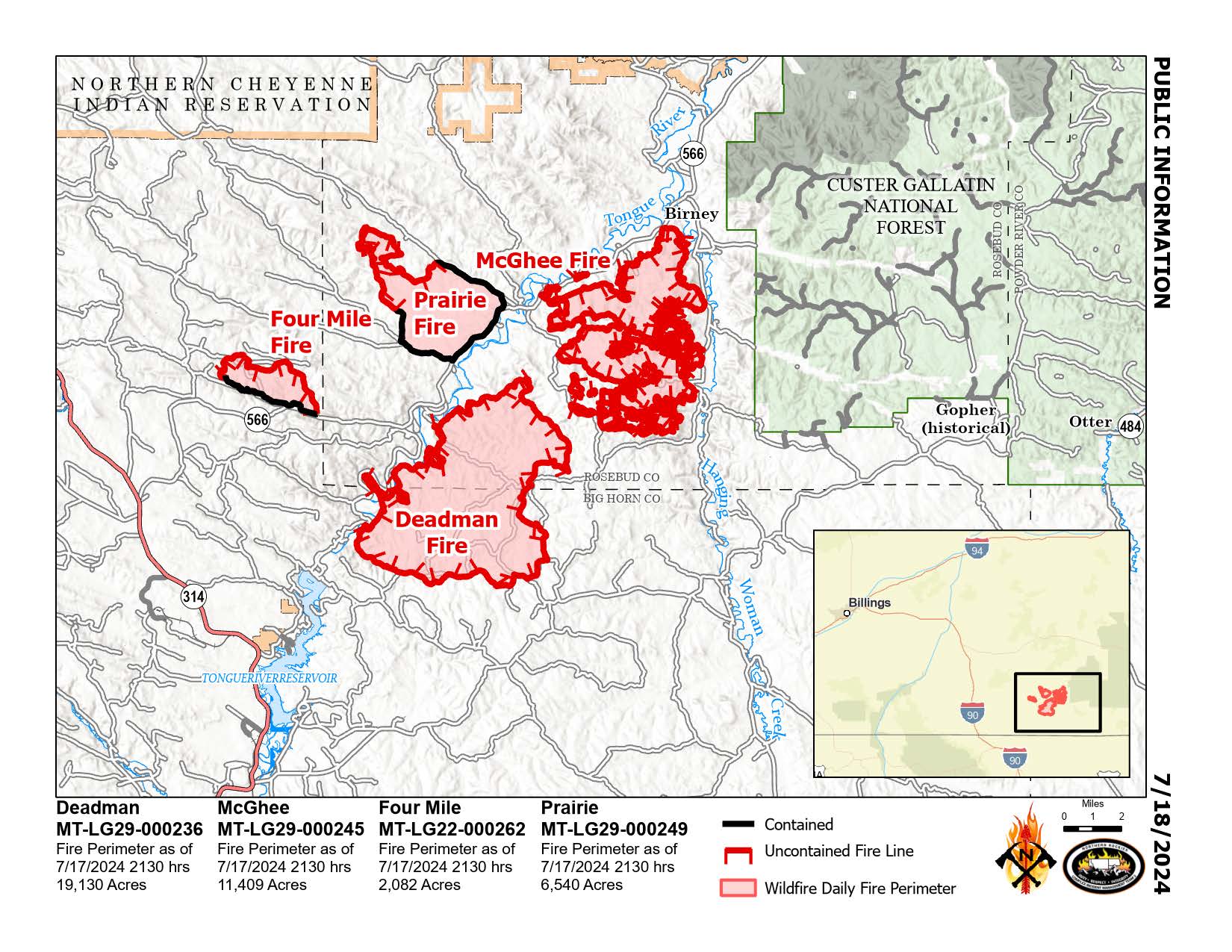
Deadman, McGhee, Prairie, and Four Mile Fires
Bureau of Land Management Montana-Dakotas State Office
Montana Department of Natural Resources and Conservation
Fire Information 406-924-3831 2024.Deadman@firenet.gov
https://inciweb.wildfire.gov/incident-information/mtmts-deadman-fire www.facebook.com/RosebudCountyDisasterAndEmergencyServices
Thursday, July 18, 2024
Northern Rockies Team 3, Incident Commander Mike Behrens
Location: South of Birney, Montana and north of Tongue River Reservoir in Rosebud and Big Horn Counties
Start Date: 7/12 and 7/13/2024
Cause: Lightning
Size: Deadman: 19,130 McGhee: 11,409 Prairie: 6,540 Four Mile: 2,082
Completion/Containment: Deadman: 20% McGhee: 9% Prairie: 50% Four Mile: 39%
KEY MESSAGE: Burnout operations yesterday on the southwest edge of the McGhee Fire were very successful, and firefighters working cooperatively with local ranchers held the line along the Wall Creek Road. Aviation assets assisted firefighters with an area of fire that pushed over the line above the Lacey Gulch Road on Wednesday evening. A Hotshot crew carried on with burnout operations west along Wall Creek Road toward the Tongue River Road. On the southern part of the west side of the Deadman Fire, the smokejumper module tended the areas where the fire is backing down to the Tongue River, taking advantage of the river as a natural barrier to fire spread. The north, east and southern perimeters of the Deadman are not exhibiting active fire behavior. An Unmanned Aerial System (drone) was used overnight to assist firefighters with small burnout operations on the east side of the McGhee Fire.
CURRENT STATUS: On McGhee, helicopters will continue to work on hot areas on the west side down into the south portion as needed, supporting the crews holding the fireline near the junction of the Tongue River Road and Wall Creek Road. A Hotshot crew will burn out areas along the Tongue River Road on the southwest edge towards Battle Butte, about four miles southwest of Birney. On the Deadman Fire, the smokejumper module will continue to secure the southwest edge as it back down to the Tongue River. On the Four Mile Fire, firefighters are cooling the remaining hot spots and patrolling the edges. The Prairie Fire is showing little heat and is being monitored.
WEATHER AND FIRE BEHAVIOR: Temperatures will approach 100 degrees F today with relative humidity in the teens and a chance of thunderstorms tonight. Winds will generally be light and easterly, with gusts to 15 mph. Active fire behavior with increases in flame length, rates of spread, and spotting distances are expected. Near critical fire conditions exist across the area. Burn periods of 16 hours are being observed.
CLOSURES AND SPECIAL MESSAGES: In Big Horn County, an evacuation warning is in place for residents from the intersection of Dale Creek Road and East Fork Canyon Road, east to the county line; from the intersection of Dale Creek Road and East Fork Canyon Road south to the intersection of Birney Road and Highway 314; from the intersection of Highway 314 and Birney Road east to the county line. In Rosebud County, an evacuation warning is in place for residents along the Tongue River Road from the Tongue River Bridge at Wall Creek to the southern Rosebud County line. Look for specific closure information and maps on the Rosebud and Big Horn County Sheriff Facebook pages. An evacuation warning means people should be aware of and monitor the situation closely, being prepared to evacuate if needed as the status could change quickly.
Horse Gulch Fire Update 07 18 2024
Related Incident: Horse Gulch Fire
Publication Type: News
Start Date & Location: July 9, 2024, 5 miles south of York, MT
Cause: Human, under investigation Size: 14,250 acres Containment: 32%
CURRENT STATUS AND PLANNED ACTIONS
Yesterday, fire growth was minimal as crews successfully maintained control and containment lines along the fire’s edge. The primary concern continues to be islands of unburned fuel within the perimeter, which could produce embers capable of sparking spot fires outside established containment lines. The southwest portion of the fire saw an increase in fire activity with a flare-up occurring. Overnight crews patrolled and secured lines, with the focus on mopping up residual heat to hold the fire within the perimeter.
Today, burning interior fuel pockets remain a significant concern due to the potential for embers to ignite spot fires outside established containment lines. Crews will patrol and secure line along Jimtown Road on the west portion of the fire. To the north, firefighters will continue with tactical firing operations in the Bar Gulch area. Crews will construct and improve hand line along the fire’s edge in the Hellgate Gulch area on the east flank of the fire. To the south, crews will continue to patrol and conduct mop-up operations within the fire perimeter, and identify areas needing suppression repair. Winds are expected to shift from the west-northwest to the northeast over the coming days, providing crews with favorable conditions to reinforce and secure control lines.
The structure protection group will continue to work in Magpie gulch, assessing homes for defensible space and improving control lines making it harder for fire to reach structures.
WEATHER AND FIRE BEHAVIOR
A chance of thunderstorms is forecasted, with the possibility of gusty and erratic winds. Temperatures will be in the 90's. Predominant W-NW winds today are forecasted at 15 mph with gusts up to 20-25 mph.
EVACUATIONS AND CLOSURES
Evacuations: Effective 7/15/24, all evacuation orders transitioned to evacuation warnings,
allowing residents of homes and RVs back into their properties. Under evacuation warning, residents should be prepared to leave if conditions change. Sheriff - Lewis & Clark County (lccountymt.gov)
Road Closure: Canyon Ferry Road remains closed to non-residents from Canyon Ferry Village to the Broadwater County line.
Campground Closure: Campground closures include Hellgate, Court Sheriff, Chinamen’s Gulch, and Riverside.
Forest Closure: The Helena-Lewis and Clark National Forest updated their forest closure. It can be found at Helena-Lewis and Clark National Forest - Home (usda.gov)
BLM Closure: The Butte Field Office has issued a closure on BLM lands near the fire area. https://inciweb.wildfire.gov/incident-publication/mthlf-horse-gulch-fire/signed-blm-area-closure-07-14-2024
Falls Fire Update 07 18 2024
Related Incident: Falls Fire
Publication Type: News
Falls Fire Update for July 18, 2024
Quick Facts:
Size: 110,674 Start Date: July 10, 2024 Location: 13.5 Miles NW of Burns, Oregon
Containment: 5% Total Personnel: 1,559 Cause: Human-caused, under investigation
Resources Assigned: 48 hand crews, 79 engines, 17 bulldozers, and 24 water tenders
The Falls Fire became very active yesterday afternoon in the northwest and northeast corners of the fire. The fire acreage is now estimated to be 110,674 with 5% containment. The fire is burning approximately 13.5 miles north of Burns, 11 miles southwest of Seneca, 7.5 miles south of Izee, and 3 miles west of Highway (Hwy) 395.
Yesterday, there was significant fire growth in the northwest and northeast areas of the fire. In the northwest corner, the fire crossed primary control lines and moved northerly down the Corral Creek drainage onto the ridge east of Donivan Mountain. Fire resources working in the area responded by building dozer line on the western flank of the fire and shifted engines and crews to protect values on private land. In the northeast corner, two spot fires started in an area north of Burnt Mountain and south of Myrtle Park Meadows just east of Forest Service Road (FSR) 31. Fire crews in the area responded and worked to line fire with dozers. Fire crews and equipment, both ground and air, continued to establish control line along the northern flank of the fire where conditions allowed for safe operations. At the southeastern area of the fire, firefighters tied in the dozer line that now connects the 3110 and 3120 roads from the Mosquito Flats area at Lone Pine Road in the south to the FSR 31 to the north near Van Zandt Meadows. Firefighters continued to be successful at keeping the fire from coming out of the Lake Creek drainage. Control lines along much of the south and west portions of the fire, along FSR 43, continue to hold firm as mop-up operations continue.
Aerial resources, including five helicopters, six single-engine air tankers (SEATs), two large air tankers (LATs), and two very large air tankers (VLATs) helped to slow the fires growth, and supported efforts to construct flanking control lines.
Today, fire behavior is predicted to be heavily influenced by very active, erratic, multi-directional winds similar to yesterday. In response to yesterday’s fire growth in the northwest and northeast corners of the fire, available resources will be shifted to these areas in an effort to protect the community of Izee and homes and ranches to the north of the fire. Fire crews and heavy equipment will be constructing control lines around where the fire grew near Donivan Mountain. In the northeast, crews and equipment will be constructing control lines around two spot fires that spotted over FSR 31 north of Burnt Mountain. Mop-up operations will continue on portions of the southern and western areas of the fire along FSR 43. Firefighters will continue to scout for future control lines.
Two Oregon State Fire Marshal (OSMF) task forces are assigned to the north and northeastern corner of the fire today. This includes the community of Izee, the Silvies Ranch area, and the City of Seneca. Two task forces will work along the 395 and 31 roads prepping structures. Structure protection is a priority for OSFM crews. Crews will continue triage assessment and fire protection efforts on the northern flank. One crew will continue to support wildland suppression efforts improving control line while moving forward with triaging efforts along the southern flanks of the fire in the Lodge Pine area. Community members with questions can contact the Non-Emergency County Information Line at 541-589-5579.
Today’s predicted weather includes very active, erratic, and shifting wind conditions. Temperature highs will be 90 – 98 degrees and with very low relative humidity levels.
Evacuation notices remain in effect in Grant and Harney Counties. For the most accurate evacuation information, please visit the Harney County Sheriff’s evacuation map here: https://tinyurl.com/3zst4sjy, or the Grant County Emergency Management Facebook page at: https://www.facebook.com/profile.php?id=100068819321423.
The Malheur National Forest issued a fire area closure. A detailed map and additional information about the fire area closure are available at: https://www.fs.usda.gov/detail/malheur/news-events/?cid=FSEPRD1188914. A temporary flight restriction (TFR) remains in place over the fire area.
Fire Information Line: 541-208-4370 Staffed 8 am to 8 pm
Email: 2024.Falls@firenet.gov
Non-emergency evacuation questions: 541-589-5579
Air quality questions: 541-573-2271
![]()
![]()
![]()
Buckhorn Fire Update Thursday 07 18 2024
Related Incident: Buckhorn Fire
Publication Type: News
Buckhorn Fire: 697 acres
Start Date: July 10, 2024
Cause: Suspected lightning
Fuels: Timber, Brush, Understory
Containment: 22%
Resources: 145
Location: Maylay Gap Area, San Carlos Reservation
Weather Cooperates for Successful Day on the Buckhorn Fire
Overview: Yesterday, crews on the Buckhorn Fire completed removing vegetation along the 2034 Road. Work along the 2030 Road is roughly two-thirds complete. Firefighters also did defensive burning operations along the 2035 Road and made good progress due to warm, dry weather conditions and favorable winds. Firefighters were also scouting along the ridges for a “backup” fire line, known as an “contingency line” to the northeast. Today, as weather permits, crews will continue defensive burning to the east and south along the 2030 Road and complete defensive burns along the 2035 Road. Dozers will work to bring the containment line north near Bull Ridge toward the Black River.
Weather: Yesterday, storm cells began to develop around the Buckhorn Fire, but did not bring any outflow winds. Today temperatures will remain between 80-85 degrees with light west/northwest winds. The storms may also bring outflow winds from the south.
Safety: Please do not fly drones anywhere near the fire. Drones may endanger firefighting aircraft. If you fly, we can’t.
Reminder: Stage 1 Fire Restrictions remain in place on the San Carlos Apache Reservation. Due to extreme drought, increasing temperatures and no rain predicted soon, the potential of catastrophic wildfire remains high. This restriction is for the protection of public health, safety, property, and natural resources. No burn permits will be issued at this time. For more information call Fire Prevention (928) 475-2326 Ext: 352, 321 or (928) 961-0515 or email asteele@forestry.scatnsn.gov or wsteele@forestry.scatnsn.gov.
Closures: There is an area closure in place around the Buckhorn Fire. Closures are being adjusted based on fire activity for public and firefighter safety. Please monitor the San Carlos Apache Tribe Facebook Page for updated information. (Link Below)
Smoke: Smoke-sensitive individuals and people with respiratory problems or heart disease are encouraged to take precautionary measures. (Link Below)
Nowhi ni’nlt’eego anlsih
Watch Fire Update Thursday 07 18 2024
Related Incident: Watch Fire
Publication Type: News
Watch Fire: 2,162 acres
Start Date: July 10, 2024
Cause: Human Caused, Under Investigation
Fuels: Cottonwood, Brush, Understory
Containment: 100%
Resources: 127
Location: 7 Mile and Peridot Districts, San Carlos Reservation
Firefighters Continue to Patrol the Watch Fire, All Evacuations Lifted
Overview: Heavy fuels well within the containment lines of the Watch Fire will continue to smoke as unburned materials are consumed. There is no threat to containment and crews will continue to monitor the fire. All areas that were in “SET” (be alert) status have been moved to “READY” (be prepared.) Although the Watch Fire is 100 percent contained, the hot, dry conditions mean fire danger is still extremely high. Residents should always be “READY” to evacuate in the event of emergencies. Information regarding what to pack in a “go bag” and how to prepare for evacuations can be found at: https://www.fs.usda.gov/Internet/FSE_DOCUMENTS/stelprdb5305121.pdf
Weather: Today temperatures should be around 100-105 degrees in lower elevations with light west/southwest winds between 5-15 mph and gusts up to 25 mph. Storm cells will continue to develop erratically with a high probability of lightning which may cause new fire starts.
Safety: Residents can expect to see occasional pockets of smoke within the interior of the Watch Fire. Areas of unburned fuel will continue to smoke within the established fire perimeter. This is normal and will continue for the next several days.
Reminder: Stage 1 Fire Restrictions remain in place on the San Carlos Apache Reservation. No burn permits will be issued at this time. For more information call Fire Prevention (928) 475-2326 Ext: 352, 321 or (928) 961-0515 or email asteele@forestry.scatnsn.gov or wsteele@forestry.scatnsn.gov.
Evacuations: Lower Seven Mile Wash, New Moonbase, Farmers Station, Downtown San Carlos, and Peridot Siding. have all been reduced to “READY” Residents are asked to avoid burned structures due to hazardous materials that may have long term health effects. For more information, call the San Carlos Apache Tribe Emergency Response Commission at 928-475-2008 or visit the TERC or the San Carlos Police Department Facebook pages. See below.
Nowhi ni’nlt’eego anlsih
Ridge Fire Daily Update 7182024 07 18 2024
Related Incident:
Publication Type: News
Wilderness Ranger District to assume command of the Ridge Fire
Daily Update – Thursday, July 18, 2024
Acres: 4,123
Start Date: 7/4/2024
Location: 19 miles east of Glenwood, NM
Personnel: 252
Containment: 23%
Fuels: Timber, grass, understory
Highlights: At 6:00 PM on Thursday, July 18, the Southwest Area Complex Incident Management Team 4 will transfer command of the Ridge Fire to Incident Commander Victor Alcorta from the Wilderness Ranger District. Team 4 extends its sincere thanks to the local communities for their support, gratitude, and hospitality throughout this incident. Due to successful firefighting efforts, the Ridge Fire is now 23% contained, and resources are either demobilizing to return to their home units or reassigning to assist other wildfires.
Future Fire Information: The Ridge Fire Information phone number and email address will no longer be active after 6:00 PM this evening. For future updates, please contact the Gila National Forest Public Affairs Officer, Maribeth Pecotte, at maribeth.pecotte@usda.gov, 575-388-8211, between the hours of 8:00 AM and 4:30 PM.
Operations: The Ridge Fire activity remains mild, and monsoonal activity is expected to continue through the weekend. The fireline near Gilita Creek on the north side is holding steady. Yesterday, aerial flights detected a portion of the fire that moved into Cooper Creek, as well as slow movement toward the southeast on the rim above Iron Creek. Crews maintained control of the north side of Iron Creek as the fire moved south into Cooper Canyon. All observed fire activity remains low, producing favorable effects as it slowly creeps through leaf litter along the forest floor. Minimal movement is expected due to increased humidity and precipitation. Disturbed areas are receiving woodchips produced from vegetation removal along the roads leading into the Willow Creek community, a strategy used to reduce erosion and repair the land following suppression activities. Road grading resumes tomorrow on Forest Road 159 to maintain safe conditions for firefighters and community members.
Weather: Showers and thunderstorms are expected to become widespread over the area during the afternoon and evening today as monsoonal moisture increases. Rain may be heavy at times, which could result in localized flash flooding. Gusty and erratic winds in the vicinity of thunderstorms are also possible. Temperatures will be cooler with increased humidity levels due to greater moisture and the expected showers.
Smoke: Smoke may be visible from Mogollon, Willow Creek, and Snow Lake. An interactive smoke map at https://fire.airnow.gov/ allows you to zoom into your area to see the latest smoke conditions. Smoke monitors are in place at the Glenwood Ranger Station, Cliff, and Gila Cliff Dwellings.
Closures: The Gila National Forest has issued an emergency temporary closure of trails and trail segments for the Ridge Fire. The purpose of the closure order is for the protection of firefighters and public health and safety during emergency wildfire suppression activities occurring in and around the trails. The full closure order (No. 03-06-05-24-002) and map are available on the Gila National Forest website at https://www.fs.usda.gov/gila.
Safety: The health and safety of firefighters and the public are always the first priority. A temporary flight restriction (TFR) is in place over the area, which includes uncrewed aircraft or drones. Flying drones near wildfires is dangerous for pilots and firefighters and can bring wildfire suppression efforts to a halt. Know before you fly. If you fly, we can’t. More information can be found at: https://uas.nifc.gov/.
More Information: https://inciweb.wildfire.gov/incident-information/nmgnf-ridge-fire /
575-323-8994 / https://www.facebook.com/GilaNForest / 2024.ridge@firenet.gov
Bench Lake Fire Update07 18 2024
Related Incident: Bench Lake Fire
Publication Type: News
Start Date: July 11, 2024
Cause: Under Investigation
Size: 1,850 acres
Percent Containment: 3%
Helicopters: 2
Scooper Planes: 2
Engines: 13
Crews: 9
Total Personnel: 331
Crews on the Bench Lake Fire were able to continue backburning operations to successfully guide the fire into Fishhook drainage yesterday, where wet and marshy terrain have lowered the intensity of the main fire. Today, crews will be working on building line along Fishhook Trail to the west to bolster defenses between the main fire and the north, including the Redfish Lodge area. On the south end of the fire, crews made good progress digging handline among the rocky terrain. Initial containment along the lake’s edge will enable firefighters to continue safely and effectively constructing fireline and increasing the containment to the south and west.
To date, aerial resources have dropped over 900,000 gallons of water on the fire. Together, scoopers and helicopters have flown more than 100 hours. The proximity of the fire to a large lake like Redfish will continue to be an asset throughout the containment process.
West to northwest winds of 10-20 mph are expected today with temperatures in the mid-80s. As the fire moves through trees impacted by insect and disease north of Redfish, the dark, gray smoke visible in the past few days is likely to persist. Due to smoke concerns, an Air Resources Advisor joined the incident this morning. Smoke reports and air quality information for the Stanley Basin and its surrounding area will be made available soon.
Restrictions: The Sawtooth National Forest has initiated Stage 1 fire restrictions within the National Forest System lands boundaries on the Sawtooth and Cassia zones. Under these restrictions, campfires are allowed only in recreation sites within metal or concrete fire pits. Fires of any kind are not allowed in any dispersed camping areas.
Speirs Fire Daily Update July 18 2024 07 18 2024
Related Incident: Speirs Fire
Publication Type: News
Recent increasing moisture trends throughout the fire area have led to a decrease invisible fire activity over the last few days. A mixture of direct and indirect line has been established along the heel of the fire. Direct line is the removal of burnable material along the blackened edge of the fire to ensure the fire is unable to continue burning through the area. In regions where firefighters are unable to directly engage the fire, indirect line is being constructed. Crews were able to begin engaging in “mopup” procedures around sections of line that have been marked as secured. Mop-up is the act of walking sections of burned ground and extinguishing remaining heat sources.
As crews continue to work towards the containment of the Speirs fire, two “Spike Camps” have been established to decrease the duration of travel that crews experience while reaching the fire. Additional resources have been ordered to assist in the fire control effort. An increase of showers entering the fire area has been forecasted to start around 12:00 PM and will likely continue through the end of the day. Thunder and lightning have been predicted around the fire area. Thunderstorms are often accompanied by strong and erratic winds that have potential to stimulate dormant hotspots. This can lead to unexpected and rapid growth of the fire.
In conjunction with the fire suppression effort, the primary goal of the team is to focus on firefighter and public safety. Incident Commander Brett Waters emphasized the mitigation of risks that firefighters take while working in challenging terrain and focused on the need to ensure firefighter safety. Waters said, “Let’s make sure we are making steady progress, while being safe, and doing the right thing.”
Closures:
Being on or within the following campgrounds, roads, and trails are prohibited on the Flaming Gorge Ranger District on the Ashley National Forest: Firefighters Memorial Campground, Greendale Group Campsite, Forest Service Road (FSR) 610, FSR 689, Lowline trail FST103 its junction with the Pipe Creek Trail, FST 003. Forest Service Trail 003 from the beginning at the junction with FST 103 to the junction of Forest Service Trail 004 and Forest Service Trail 004 to Greens Draw Road 049.
For more information on existing closures, please visit the Ashely National Forest website at https://www.fs.usda.gov/alerts/ashley/alerts-notices The Flaming Gorge National Recreation Area remains open to the public for recreational opportunities.
Temporary Flight Restrictions (TFR): A TFR is in effect over the Speirs Fire area. Using uncrewed aerial systems (UAS)/drones is illegal within the TFR.
Start date: July 13, 2024
Location: Approximately three miles south of the town of Dutch
John, Utah and south of Flaming Gorge Reservoir.
Fire size: 759 acres
Containment: 3%
Total personnel: 283
Cause: Naturally-Caused, Lightning
Speirs Fire Information Number: 435-709-8209 (8:00 AM to 8:00 PM.)
Trout Fire Closure Forest Order No 15132412 07 18 2024
Related Incident: 2024 SQF Lightning
Publication Type: Closures
The Sequoia National Forest issued Forest Order No. 0513-24-12 to temporarily close lands, trails, roads, and recreation sites around the Trout Fire. This order goes into effect July 18, 2024 and expires July 28, 2024.
See the attached PDF for the official Forest Order and accompanying map.
Hill Fire Forest Closure Order 07 17 2024
Related Incident: Hill Fire
Publication Type: Closures
Six Rivers National Forest Forest Order No. 24-10-07 Hill Fire Closure
Pursuant to 16 U.S.C. § 551 and 36 C.F.R. § 261.50(a) and (b), and to provide for public safety,
the following acts are prohibited within the Lower Trinity Ranger District of the Six Rivers
National Forest. This Order is effective from July 18, 2024, through September 15, 2024.
1. Going into or being upon National Forest System lands within the Hill Fire
Closure Area, as described in Exhibit A and shown on Exhibit B. 36 C.F.R.
§261.52(e).
2. Being on any National Forest System road within the Hill Fire Closure Area, as
shown on Exhibit B. 36 C.F.R. § 261.54(e).
3. Being on any National Forest System trail within the Hill Fire Closure Area, as
shown on Exhibit B. 36 C.F.R. § 261.55(a).
4. Entering or using East Fork Campground or Big Rock River Access. 36 C.F.R.§ 261.58(b).
Pursuant to 36 C.F.R. § 261.50(e), the following persons are exempt from this Order:
1. Persons with Forest Service Permit No. FS-7700-48 (Permit for Use of Roads,
Trails, or Areas Restricted by Regulation or Order), specifically exempting them
from this Order.
2. Any Federal, State, or local officer, or member of an organized rescue or firefighting
force in the performance of an official duty.
3. Owners, lessees, or residents of private landholdings in the area, to the extent
necessary to access their land.
These prohibitions are in addition to the general prohibitions contained in 36 C.F.R. Part 261,
Subpart A.
A violation of these prohibitions is punishable by a fine of not more than $5,000 for an individual
or $10,000 for an organization, or imprisonment for not more than six months, or both. 16 U.S.C.
§ 551 and 18 U.S.C. §§ 3559, 3571, and 3581.
Executed at Eureka, California this 17th day of July, 2024.
Exhibit A
The Hill Fire Closure Area comprises a portion the southwestern quarter of the Lower Trinity
Ranger District of the Six Rivers National Forest as shown on Exhibit B. The closure area begins
where Highway 299 and the South Fork Trinity River intersect, the closure continues south along
the South Fork Trinity River to the Shasta Trinity National Forest boundary. The closure
continues west along the Shasta Trinity National Forest boundary until it intersects with
Township 4 North, Range 5 East, Section 25. The closure follows the northern section line of
Township 4 North, Range 5 East, Section 25 through 30, west until it intersects the western
boundary of the Six Rivers National Forest. The closure area then continues north along the Six
Rivers National Forest boundary until it intersects with Forest Road 4N06 (Cow Creek Road).
The closure area follows Forest Road 4N06 northwest until it intersects with Forest Route 1. The
closure area continues north on Forest Route 1 until it intersects with Township 3 North, Range 4
East, Section 2. The forest closure area continues west along the southern edge of Township 3
North, Range 4 East, Section 2 to the western edge of Township 3 North, Range 4 East, Section
3. The forest closure area turns north at the southwest corner of Section 2 until it intersects Forest
Route 1. The closure area follows Forest Route 1 north, and Titlow Hill Road, until it intersects
with Highway 299. The forest closure area continues to the east along Highway 299 until it
returns to the starting point at the South Fork Trinity River.
Signed by Ted Mcarthur, Forest Supervisor, Six Rivers National Forest