
Daily Update 07 16 2024
Related Incident: Black Fire
Publication Type: News
Evacuations: There are currently “GO” orders in place for Tonto National Monument, Black Brush Ranch, Cross-P Ranch, Reevis Mountain School, Cottonwood Cove Picnic Area, Frazier, Windy Hill, Schoolhouse, and Grapevine Campgrounds. There are “SET” orders in place for Quail Run, Roosevelt Post Office, Lakeview Mobile Home Park, and Roosevelt Lake Marina and RV Park. Boat ramps at Cholla and Windy Hill are currently open.
Closures: The Tonto National Forest has issued a closure for land surrounding the Black Fire. View the full closure on its website. Additionally, the Tonto National Monument is closed.
Operations: On Monday, crews continued structure protection efforts within the Tonto National Monument, focusing on cultural resources in the area. The fire spread at a rapid pace to the east throughout the day, causing crews to conduct firing operations ahead of the main fire to help stop fire spread toward the Black Brush ranch. Aviation resources, including helicopters and air tankers, were utilized along the east side of the fire to help slow it’s spread. Today, crews will continue to improve and reinforce firelines around the north and east sides of the fire and improve Forest Road 49 for use as a fireline on the west.
Weather: The high Tuesday will be 103 degrees, with 20-25 mph southwest wind. There is a chance for thunderstorms in the afternoon bringing wind, lightning, and rain. Fuel moisture is critically low, and fuels are very receptive to fire.
Safety: The health and safety of firefighters and the public are always the highest priority. Please avoid the area while crews conduct fire suppression operations. Citizens are urged to sign up for the Gila and Maricopa County Emergency Notification System. To learn more about the Arizona Emergency Information Network visit: https://ein.az.gov/ready-set-go. Firefighting aircraft and drones are a dangerous combination. Drones in the area could lead to accidents or slow down wildfire suppression operations. If you fly…we can’t.
Smoke: There is moderate to heavy smoke present from the Black Fire as well as other fires in the area. Individuals who are sensitive to smoke or have conditions aggravated by smoke are encouraged to take precautionary measures. An interactive smoke map at https://fire.airnow.gov/ allows you to zoom into your area to see the latest smoke conditions.
Location: South of Roosevelt Lake on the edge of the Superstition Wilderness
Start Date: July 11, 2024
Size: Approximately 8,679 acres
Percent Contained: 0%
Cause: Lightning
Vegetation: Tall Grass and Brush
Resources: 9 Handcrews, 7 Helicopters, 9 Engines, 1 Dozer, and 4 Water Tenders.
Number of Personnel Assigned: 362
Tonto National Forest: https://www.fs.usda.gov/main/tonto/fire
InciWeb: Black Fire Fire email: 2024.black.az@firenet.gov Information Phone: 928-295-1514
Social Media: X @TontoForest and Facebook @TontoNationalForest
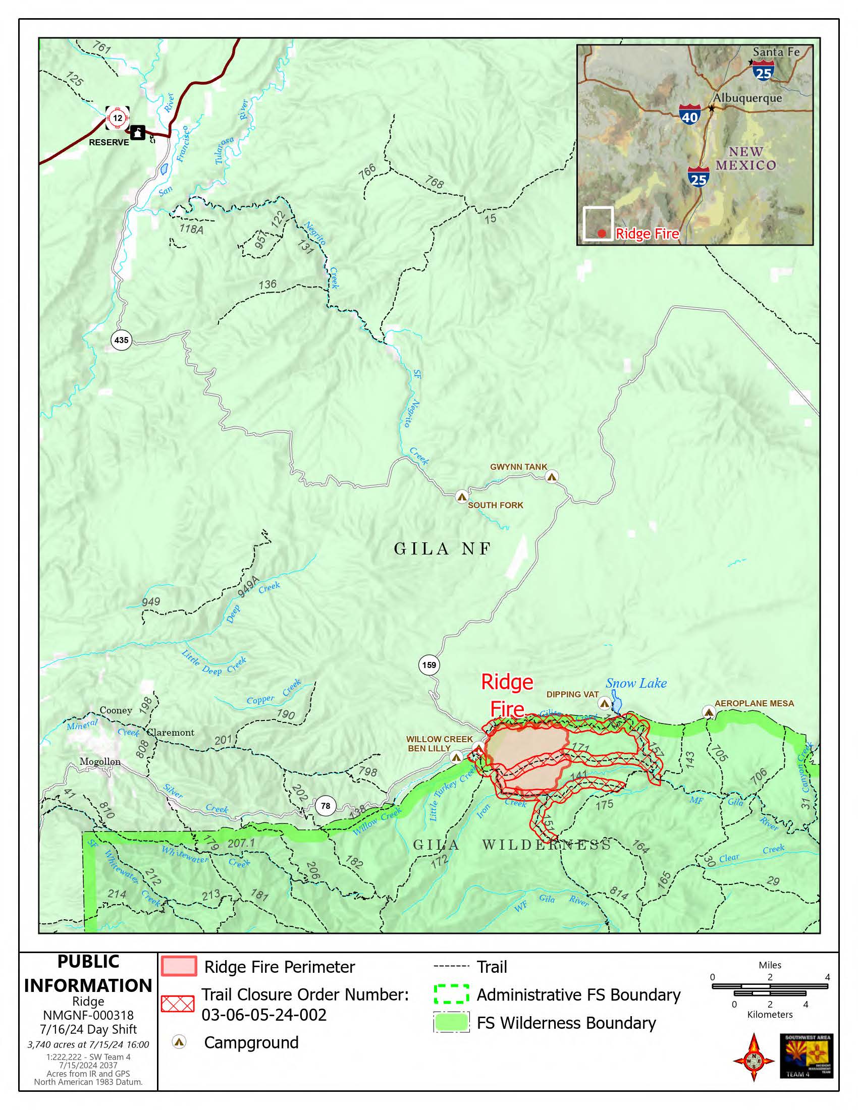
Ridge Fire Daily Update 07 16 2024
Related Incident:
Publication Type: Announcement
Firefighters prepare for oncoming rains on the Ridge Fire
Daily Update – Tuesday, July 16, 2024
Acres: 3,740
Start Date: 7/4/2024
Location: 19 miles east of Glenwood, NM
Personnel: 321
Containment: 20%
Fuels: Timber, grass, understory
Highlights: Fire activity is expected to decrease with incoming rain forecasted today and through the week. Firefighters are completing erosion prevention activities around the fire area, including seeding and installing water bars on constructed handlines and Forest Road 159, and using chipping materials to add mulch to disturbed areas at the fire camp.
Operations: Yesterday, firefighters completed a reconnaissance flight to establish a new perimeter and updated acreage for the fire. As temperatures rose, fire grew with low intensity on the southern and eastern edges. The fire continues to smolder across the basin and creek bottoms, burning through a heavy layer of dead and downed leaf litter. Despite some growth, crews were able to successfully hold their containment lines on Trail #151. Water bars were installed on Forest Road 159 to divert water off handlines in the event of heavy rainfall. Fire crews monitored the northern side of the fire perimeter down into Gilita Creek with an uncrewed aircraft system (UAS) that captures infrared and aerial imagery to help inform strategic planning. Firefighters are using a chipper to cut branches and logs into small wood chips along Willow Creek on Forest Road 159. Crews are hauling the wood chips out of the area to minimize potential debris in Willow Creek. Firefighters expect to complete these chipping operations in Willow Creek by late morning, ahead of predicted rains. Grading will continue along Forest Road 159 to improve road conditions as fire vehicles travel the roadways. Fire activity is still limited to smoldering and creeping, although it is expected to decrease further with the incoming rain. UAS will likely be used again today to provide more information about fire progression in the Iron Creek area where the federally protected Gila trout are located. Deploying the UAS in steep terrain like Iron Creek is a strategic action fire managers use to minimize potential safety risks to firefighters.
Weather: An increase in moisture will result in numerous showers and thunderstorms this afternoon and into the night. Some gusty and erratic winds will occur in the vicinity of thunderstorms. The additional moisture could result in just slightly cooler temperatures than Monday, with slightly higher humidity values.
Smoke: Smoke may be visible from Mogollon, Willow Creek, and Snow Lake. An interactive smoke map at https://fire.airnow.gov/ allows you to zoom into your area to see the latest smoke conditions. Smoke monitors are in place at the Glenwood Ranger Station, Cliff, and Gila Cliff Dwellings.
Closures: The Gila National Forest has issued an emergency temporary closure of trails and trail segments for the Ridge Fire. The purpose of the closure order is for the protection of firefighters and public health and safety during emergency wildfire suppression activities occurring in and around the trails. The full closure order (No. 03-06-05-24-002) and map are available on the Gila National Forest website at https://www.fs.usda.gov/gila.
Safety: The health and safety of firefighters and the public are always the first priority. A temporary flight restriction (TFR) is in place over the area, which includes uncrewed aircraft or drones. Flying drones near wildfires is dangerous for pilots and firefighters and can bring wildfire suppression efforts to a halt. Know before you fly. If you fly, we can’t. More information can be found at: https://uas.nifc.gov/.
More Information: https://inciweb.wildfire.gov/incident-information/nmgnf-ridge-fire /
575-323-8994 / https://www.facebook.com/GilaNForest / 2024.ridge@firenet.gov
Deadman Fire Daily Update 07 16 2024
Related Incident:
Publication Type: News
Video Update: https://fb.watch/tmSME7uVku/
Deadman, McGhee, Prairie, and Four Mile Fires
Bureau of Land Management Montana-Dakotas State Office
Montana Department of Natural Resources and Conservation
Fire Information 406-924-3831 2024.Deadman@firenet.gov
https://inciweb.wildfire.gov/incident-information/mtmts-deadman-fire www.facebook.com/RosebudCountyDisasterAndEmergencyServices
Tuesday, July 16, 2024
Northern Rockies Team 3, Incident Commander Mike Behrens
Location: South of Birney, Montana and north of Tongue River Reservoir in Rosebud and Big Horn Counties
Start Date: 7/12 and 7/13/2024
Cause: Lightning
Size: Deadman: 18,927 McGhee: 3,553 Prairie: 6,540 Four Mile: 2,082
Completion/Containment: Deadman: 20% McGhee: 10% Prairie: 50% Four Mile: 1%
KEY MESSAGE: Fire managers assessed the fires yesterday, and containment numbers have gone up. Where the fires are contained, there is cold black line around the edges and a very low probability that the fire will cross fire lines. They will continue to assess the fires today and these numbers will likely increase. Yesterday, fire managers took a reconnaissance flight and confirmed the Hackley and Prairie fires had burned together, reaching an estimated combined 6,540 acres. This fire will now be referred to as the Prairie Fire.
CURRENT STATUS: The most active fire is McGhee, pushing east and north towards Birney on Sunday night. On Monday, crews conducted successful burnouts along the north side and will continue strengthening those lines today. South of Pyramid Butte on the east, the fire made a big push towards Hanging Woman Creek Monday afternoon. A grader improved lines along the eastern side while crews did burnout operations, supported by Very Large Air Tankers (VLATs) with retardant drops. An overnight shift worked to hold and improve the lines. Fire managers are assessing and implementing a strategy to tie together the eastern and southern lines. The Deadman Fire remains active on the west side, backing towards the Tongue River. While the terrain makes it difficult to access, crews will look for opportunities to use an Unmanned Aerial System (drone) to conduct burnout operations to bring the fire down to and hold it on the river. On the Four Mile Fire, firefighters are cooling the remaining hot spots and patrolling the edges. The Prairie Fire is showing little heat and is being monitored.
WEATHER AND FIRE BEHAVIOR: The weather remains hot and dry for the foreseeable future. Another cold front today brings slightly cooler temperatures and higher humidity. However, as this front passes, a ridge of high pressure will build, bringing hotter temperatures and lower humidity.
CLOSURES AND SPECIAL MESSAGES: In Big Horn County, an evacuation warning is in place for residents from the intersection of Dale Creek Road and East Fork Canyon Road, east to the county line; from the intersection of Dale Creek Road and East Fork Canyon Road south to the intersection of Birney Road and Highway 314; from the intersection of Highway 314 and Birney Road east to the county line. In Rosebud County, an evacuation warning is in place for residents along the Tongue River Road from the Tongue River Bridge at Wall Creek to the southern Rosebud County line. Look for specific closure information and maps on the Rosebud and Big Horn County Sheriff Facebook pages.
An evacuation warning means people should be aware of and monitor the situation closely, being prepared to evacuate if needed as the status could change quickly.
Basin Fire Update 07 16 2024
Related Incident: Basin Fire
Publication Type: News
Basin Fire Update
Tuesday July 16, 2024
Information: (559) 855-5355
Email: 2024.basin@firenet.gov
Facebook: @SierraNF
PEOPLE AND EQUIPMENT: 207 personnel, 4 crews, 4 engines, 3 helicopters, 2 dozers and 5 water tenders
CURRENT SITUATION: The Basin Fire is 14,023 acres, with no increase in acreage. Containment remains at 95%. The threat of thunderstorms is minimal for the next few days. Slightly cooler, more seasonable temperatures are forecast through tomorrow, before a warming trend returns to the area by the end of the week and into the weekend. Dryer conditions will prevail with low humidity, poor overnight recoveries, and mainly terrain driven winds. Temperatures today are expected to reach 96 to 100 degrees in lower elevations of the fire line with daytime relative humidity 20% to 30%. Winds are forecast to remain low, from the southwest at 9 mph, with gusts to 20 mph. There is a chance of thunderstorms this coming weekend.
Firefighters continue to monitor the fire line and backhaul any equipment that is no longer needed. Some resources have been loaned to assist with new wildfires in the area.
Fire Suppression: Firefighters continue to patrol and monitor for any flare-ups, threats to the containment line, and visible smoke. Unburned areas within the fire’s western perimeter may produce smoke. When available aircraft will assist firefighters in monitoring the fire line and will use water drops when necessary.
Suppression Repair: Suppression repair efforts continue in areas of the fire that are no longer posing a threat. Due to very dry fuels, firefighters have not been using dozers due to the risk of starting a spot fire. Hand tools are being used in these areas to return them to as natural a state as practical, until the use of heavier equipment can be re-introduced.
The Basin Fire started on June 26, 2024, and the cause is currently under investigation. The fire is at 2000-4500 feet elevation, northeast of Pine Flat Lake, west of the Spanish Mountain, south of Black Rock Rd (11S012) and north of the South Fork of the Kings River.
Fire updates are posted on Inciweb: https://inciweb.wildfire.gov/incident-information/casnf-basin-fire.
FOREST CLOSURE and FIRE RESTRICTIONS for the Basin Fire: To ensure the safety of the public and our firefighters, The Sierra National Forest has issued a Temporary Partial Forest Closure Orders No. 05-15-52-24-19 & 20 for the Basin Fire area. Effective July 10, 2024, the closure will remain in effect until July 31, 2024. We urge the public to respect all closure signs and barriers and to avoid the area to prevent any potential accidents or interference with firefighting efforts.
Check https://www.fs.usda.gov/sierra for the Basin Fire closure area map. Roads & trails in this area on the Sierra National Forest are CLOSED.
The Sierra National Forest has implemented temporary fire restrictions prohibiting campfires except within designated recreation sites. Operating vehicles off roads or trails is prohibited, and welding is prohibited. Smoking is only allowed in vehicles, buildings and designated recreation sites.
Visit https://www.fs.usda.gov/sierra for more information or call the Sierra National Forest (559) 855-5355 during business hours for questions.
Bench Lake Fire Update 07 16 2024
Related Incident: Bench Lake Fire
Publication Type: News
Start Date: July 11, 2024
Cause: Under Investigation
Size: 1,275 acres
Percent Containment: 0%
Helicopters: 3
Scooper Planes: 2
Engines: 12
Crews: 5
Total Personnel: 259
Fire activity increased yesterday with growth on the northwest corner of the Bench Lake Fire. Heavy smoke from high volumes of dead timber in the area drifted mainly East, a change from Sunday when it moved South. The change in fire acreage is due to more accurate mapping resulting with increased visibility of the fire’s perimeter from the air.
On the west side of Redfish Lake, the fire moved more slowly downhill towards the lake. Low-intensity burning will contribute to a mosaic burn, where many older trees will survive and the underbrush will return in abundance. As the fire reaches the lake, firefighters will begin to achieve containment from the lake’s edge, directly along the active southern fire perimeter, and up towards the ridge.
On the north side of Redfish Lake, crews are focused on structure protection while improving mitigation efforts around Redfish Lodge and adjacent structures throughout the compound. Sprinklers, water pumps, and an extensive network of hoses have been strategically placed to ensure adequate water support. Crews are removing fuels with chainsaws along the Fishhook Creek Trail system.
Helicopters and scooping aircraft are continuing to cool the fire’s edge with water drops. Aviation resources and crews are identifying and using natural barriers – including riparian areas, ridges, and rocky outcroppings – as control areas where the fire activity will be naturally slowed and limit the fire’s overall size.
There is a slight chance of thunderstorms tomorrow. The greatest concerns with these storms are erratic outflow winds and the potential for new fires to ignite. Firefighters will maintain awareness of these conditions and adjust their locations and tactics as needed to stay safe and have the greatest chance of success in containing the fire.
Community Meeting: Wednesday, July 17 at 7:00 p.m. at the Community Building in the Stanley, Idaho (500 Eva Falls Ave.)
Closures: Sawtooth National Recreation Area officials issued an emergency closure for the Bench Lake Fire (0414-04-147) July 12 for the Redfish Lake recreation complex, including the lodge and associated buildings, roads, trails, trailheads, and campgrounds in the area. Visit https://www.fs.usda.gov/alerts/sawtooth/alerts- notices for a map and more details on the closure order. Both Highway 21 and Highway 75 remain open. Increased fire traffic and potential poor visibility warrant slowing down.
Trout Fire Closure Forest Order No 15132411 07 16 2024
Related Incident: 2024 SQF Lightning
Publication Type: Closures
SEQUOIA NATIONAL FOREST
Forest Order No. 0513-24-11
Trout Fire Closure
Pursuant to 16 U.S.C. § 551 and 36 C.F.R. § 261.50(a) and (b), and to provide for public safety, the following acts are prohibited within the Kern River Ranger District of the Sequoia National Forest. This order is effective from July 14, 2024.
1. Going into or being upon any National Forest System lands within the Trout Fire Closure Area, as described in Exhibit A and shown on the attached map. 36 C.F.R. §261.52(e).
2. Being on any National Forest System trails within the Trout Fire Closure Area, as described in Exhibit A and shown on the attached map. 36 C.F.R. § 261.55(a).
3. Being on any National Forest System roads within the Trout Fire Closure Area, as described in Exhibit A and shown on the attached map. 36 C.F.R § 261.54(e).
4. Entering or using any Developed Recreation Sites within the Trout Fire Closure Area, as described in Exhibit A and shown on the attached map. 36 C.F.R. § 261.58(b)
Pursuant to 36 C.F.R. § 261.50(e), the following persons are exempt from this Order:
1. Persons with Forest Service Permit No. FS-7700-48 (Permit for Use of Roads, Trails, or Areas Restricted by Regulation or Order), specifically exempting them from this Order.
2. Any Federal, State, or local officer, or member of an organized rescue or firefighting force in the performance of an official duty.
3. Owners or lessees of land in the area, to the extent necessary to access their property.
These prohibitions are in addition to the general prohibitions in 36 C.F.R. Part 261, Subpart A.
A violation of these prohibitions is punishable by a fine of not more than $5,000 for an individual or $10,000 for an organization, or imprisonment for not more than 6 months, or both. 16 U.S.C. § 551 and 18 U.S.C. §§ 3559, 3571, and 3581.
Executed in Porterville, California, this 14th day of July, 2024.
Anthony Edwards
Forest Supervisor, Sequoia National Forest
Forest Order No. 0513-24-11
USDA FOREST SERVICE
PACIFIC SOUTHWEST REGION
SEQUOIA NATIONAL FOREST
Trout Fire Closure
The Trout Fire Closure Area boundary begins at the intersection of the Sequoia National Forest Boundary and Sierra Way (Mtn 99) in Section 14, Township 25 South, Range 33 East, Mount Diablo Base & Meridian, then continues approximately 76.5 miles south, east, north, and west along the Forest Boundary to its intersection with the North Fork of the Kern River in Section 1, T. 20 S., R. 34 E., MDB&M, then continues approximately 24 miles south along the Kern River to its intersection with Mtn 99 in Section 35, T. 22 S., Range 32 E., MDB&M, then continues along Mtn 99 approximately 20.3 miles to the starting point.
Vista Fire Evening Update Spanish 07 15 2024
Related Incident: Vista Fire
Publication Type: News
ACTUALIZACIÓN DEL INCIDENTE DE LA TARDE
Fecha: 7-15-2024 Hora: 18:00
Tamaño: 2936 acres
Contención: 59%
Total de personal: 610
Estructuras amenazadas: 416
Fecha/hora de inicio: 7-7-24 9:51 a
Causa: Bajo investigación
Ubicación: Lado sur de Lytle Creek
Durante las operaciones de incendio de hoy, los equipos de bomberos se centraron en mejorar las líneas de mano, patrullar en busca de focos de incendio y llevar a cabo operaciones de limpieza a lo largo del perímetro del incendio. La mayor parte del comportamiento del fuego observado ha sido mínimo y no se ha registrado ningún crecimiento significativo. Los medios aéreos apoyaron las operaciones lanzando agua y coordinándose con los bomberos nocturnos que estaban estableciendo líneas de control en el Cucamonga Wilderness. Han comenzado las operaciones de reparación del incendio, y las cuadrillas están utilizando astilladoras a lo largo de las líneas de contención del incendio. La contención ha aumentado hasta el 59%.
Una Orden Forestal ha cerrado varias carreteras, senderos y zonas de recreo en la zona del incendio de Vista. El público tiene prohibido entrar en el bosque a través de Lytle Creek Road.
CALIDAD DEL AIRE:
Visita AirNow.gov para obtener información y medidas que puede tomar para protegerse y proteger a sus seres queridos.
CIERRE DE CARRETERAS:
Lytle Creek Road está cerrado al público en general, incluyendo todas las áreas de recreación al norte de Glen Helen Parkway.
EVACUACIONES:
Ninguna.
Nota: En un esfuerzo por comunicar rápidamente información sobre peligros inminentes, el Departamento del Sheriff del Condado de San Bernardino y el Departamento de Bomberos del Condado de San Bernardino envían notificaciones masivas de alta velocidad por teléfono y mensajes de texto. Este sistema se conoce como Sistema Telefónico de Notificación de Emergencias (TENS). Para obtener más información sobre este servicio, visite el sitio web: https://sbcfire.org/alertwarning/.
CIERRES:
Orden de cierre en vigor en el Bosque Nacional de San Bernardino y el Bosque Nacional de Angeles. Varias carreteras, campings, áreas de picnic, senderos y áreas recreativas dispersas están cerradas al público para garantizar la seguridad de los bomberos, la comunidad y el público. Las actividades recreativas están prohibidas dentro de la zona de cierre. Más información sobre la orden de cierre está disponible en los sitios web de los bosques nacionales en https://www.fs.usda.gov/alerts/sbnf/alerts-notices y https://www.fs.usda.gov/alerts/angeles/alerts-notices.
RESTRICCIONES CONTRA INCENDIOS:
El Bosque Nacional de San Bernardino ha aumentado las restricciones contra incendios. Las hogueras están restringidas a las zonas urbanizadas enumeradas en el Forest Order.
Evening Update July 15 Miller Peak Fire 07 16 2024
Related Incident:
Publication Type: News
At an estimated acreage of 800 acres, the Miller Peak Fire continued working its way to the north and east this afternoon. Hot temperatures, dry conditions and gusty winds resulted in increased fire behavior.
Aviation resources and crews worked to establish an anchor point on the less-active southern flank in the Plant Creek drainage. Aviation was used on both the east and west flanks to control the fire's progression.
Working in cooperation with community officials and local agencies, fire managers have identified and prioritized critical values at risk, focusing available resources and current efforts on the protection of the homes and structures in the Miller Creek drainage and the communications towers on Miller Peak.
Firefighters are currently scouting roads in order to gain better access to the fire area. Protecting life and property and ensuring firefighter safety are of the utmost importance during any incident. Steep slopes, rugged terrain, and the extremely active fire behavior all pose challenging situations for firefighters on the ground.
Resources on scene include 8 engines, 2 helicopters, air tankers, three handcrews, and miscellaneous overhead. Additional resources, including crews and a Complex Incident Management Team have been ordered. The cause of the fire is under investigation.
Fire managers and Lolo NF officials are discussing a fire area closure, allowing for safe firefighting operations and the continued safety of the public. Details on the closure area will be forthcoming.
For current information please visit https://inciweb.wildfire.gov/incident-information/mtlnf-miller-peak-fire
**𝐄𝐕𝐀𝐂𝐔𝐀𝐓𝐈𝐎𝐍 𝐖𝐀𝐑𝐍𝐈𝐍𝐆**
𝐃𝐄𝐒𝐂𝐑𝐈𝐏𝐓𝐈𝐎𝐍 𝐔𝐏𝐃𝐀𝐓𝐄 for the 𝐌𝐢𝐥𝐥𝐞𝐫 𝐏𝐞𝐚𝐤 𝐟𝐢𝐫𝐞: Residents from 14380 Upper Miller Creek Road to the junction of the West Fork Schwartz Creek Road and then from the Junction of West Fork Schwartz Creek Road to 7018 West Fork Schwartz Creek Road are under an EVACUATION WARNING.
Information on the Miller Peak fire can be found at https://inciweb.wildfire.gov/incid.../mtlnf-miller-peak-fire
While every effort will be made to first issue and Evacuation WARNING, please be aware that due to the possibility of rapidly changing conditions, an Evacuation ORDER may be issued with no prior notice or warning.
If you are not enrolled in SMART911, now is the time to do so. Log on to smart911.com and create your safety profile. This service will enhance your ability to receive alerts and provide information to responders to enhance your family's safety.
Evacuation Levels Update July 15 2024 7152024 07 15 2024
Related Incident: Cow Valley Fire
Publication Type: Announcement
Updated Evacuation Levels (2:30pm July 15)
In consultation with fire officials the Malheur County Sheriff’s Office issuing the following updates:
No Evacuations Levels
• Residents of Hwy 26 Corridor (Willow Creek, Jaimeson, Brogan) and the NW of Vale (Graham Blvd and North, Alder Road and west)
• ALL READINESS CONDITIONS HAVE LIFTED. Fire crews continue to monitor these areas.
• The City of Vale is not in danger at this time.
Level 1 – Be Ready – Green
• None at this time.
Level 2 – Get Ready – Green
• Westfall area (including Bonita, Indian Valley, Clover Creek areas)
• This area REMAINS in the “Get Set” or the next level of preparedness. Fire activity on the Cow Valley Fire has advanced slowly on the southern side of the fire and preparations should be made in case weather conditions and fire behavior increase. You should have your travel supplies and companion animals ready to go. Plans should be set. unless you need extra time to get out and travel.
The Red Cross Evacuation Shelter in Ontario will demobilize at noon on 07/16/2024. However, if citizens are evacuated from the Westfall area, plans have been made and a shelter will be set up in Vale. More information to come. Call the Emergency Manager at (541) 709-7726 if you need shelter accommodations.
For additional information and updates on the Cow Valley Fire, visit
Vista Fire Evening Update 07 15 2024
Related Incident: Vista Fire
Publication Type: News
Size: 2936 acres
Start Date & Time: 7-7-24 9:51
Containment: 59%
Cause: Under Investigation
Total Personnel: 610
Location: Southside of Lytle Creek
Structures Threatened: 416
During today’s fire operations, fire crews focused on enhancing handlines, patrolling for spot fires and conducting mop-up operations along the fire perimeter. Most of the observed fire behavior remained minimal, with no significant growth reported. Air assets supported operations by dropping water, coordinating with the overnight firefighters who were establishing handlines in the Cucamonga Wilderness. Fire suppression repair operations have commenced, and crews are using chippers along the fire containment lines. Containment has increased to 59 percent.
A Forest Order has closed several roads, trails and recreation areas in the Vista fire area. The public is prohibited from entering the forest through Lytle Creek Road.
AIR QUALITY:
Visit AirNow.gov for information and actions you can take to protect yourself and loved ones.
ROAD CLOSURES:
Lytle Creek Road is closed to the general public including all recreation areas north of Glen Helen Parkway.
EVACUATIONS:
None.
Note: In an effort to quickly communicate information on impending dangers, the San Bernardino County Sheriff Department and San Bernardino County Fire Department send high-speed mass notifications via telephone and text messages. This system is known as the Telephone Emergency Notification System (TENS). To learn more about this service, visit the website for more information: https://sbcfire.org/alertwarning/.
CLOSURES:
Closure order in effect on the San Bernardino National Forest and the Angeles National Forest. Several roads, campgrounds, picnic areas, trailheads, and dispersed recreation areas are closed to the public to provide for firefighters, community and public safety. Recreation activities are prohibited within the closure area. More information about the closure order is available on the national forest websites at https://www.fs.usda.gov/alerts/sbnf/alerts-notices and https://www.fs.usda.gov/alerts/angeles/alerts-notices
FIRE RESTRICTIONS:
The San Bernardino National Forest has implemented increased fire restrictions. Campfires are restricted to those developed areas listed in the Forest Order.