
Grizzly Creek Fire August 16 2020
Related Incident:
Publication Type: News
Grizzly Creek Fire
August 16, 2020 Update
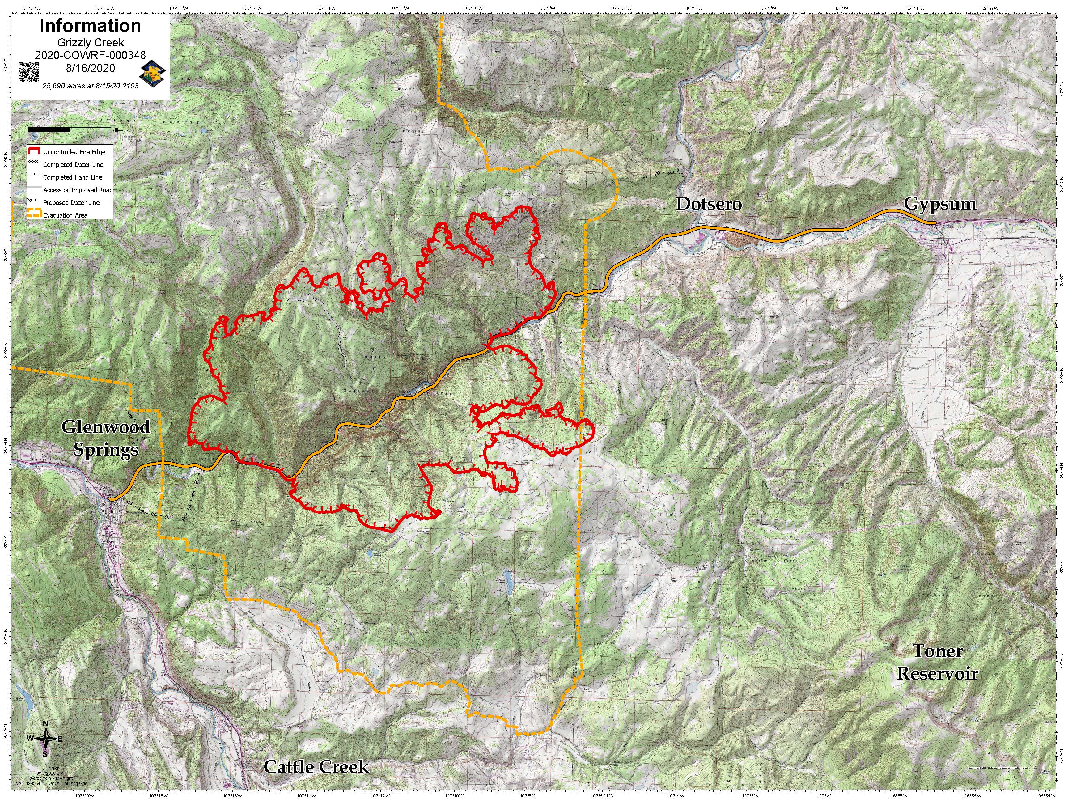
Grizzly Creek Fire – 25,690 acres
Start Date: Aug. 10
Location: Glenwood Canyon
Containment: 0%
Resources:
Hand Crews: 15
Helicopters: 13
Engines: 32
Water Tenders: 7
Dozers 4
Feller bunchers and other logging equipment
Total Personnel: 625
InciWeb: https://inciweb.nwcg.gov/incident/6942/
Facebook:
https://www.facebook.com/GrizzlyCreekFireCO
Twitter: @fire_grizzly
Fire Information Line:
(970) 930-1850
Media Line:
(970) 930-1089
Office Hours: 7am-10pm
Email: 2020.grizzlycreek@firenet.gov
Yesterday’s Activity: Skies were clear early in the day as the inversion lifted causing higher temperatures and a more active fire. By midafternoon the fire on the north flank made a run from grizzly creek to Coffee Pot Road. The fire did spot across the road, but firefighters were able to catch it as the fuel types transitioned from timber to sage. Spot fires from the previous night grew together and moved towards Bair Ranch. Dozer line around Bair Ranch and structure protection measures, were successful in holding back the fire resulting in no loss of structures. Fire on the southeast edge is holding just shy of Spruce ridge. Heavy smoke in late afternoon was due to the fire pushing between the Deadman canyon and Devil’s Hole Canyon. The fire has moved to the canyon rim and is holding. Activity in the No Name area was quiet as the containment lines held and crews worked to bring in water with hose lays and aerial water drops.
Today’s Activity: Firefighters will continue implementing structure protection measures around the gondola at Adventure Park and will move north to Transfer Trail with heavy equipment building indirect line. Crews will work to keep fire south of Coffee Pot Road by constructing and reinforcing control lines. Crews will engage the fire where they safely can. Direct attack of the fire has been difficult due to the rugged and steep terrain. Firefighters will hold and improve line construction as fire comes out of deep canyons. At this time the fire is held up on Spruce Ridge, however, there are stringers of heavy timber that are concerning. Contingency line to the east will be implemented by heavy equipment. Today heavy air tankers will be shared with the Pine Gulch Fire. Daily operations video updates will be posted on the Grizzly Creek Fire facebook page. Maps and other information will also be posted on inciweb at https://inciweb.nwcg.gov/incident/6942/.
Evacuations: Please go to Garfield County website at www.Garfield-county.com and Eagle County at www.ecemergency.org, as well as on official FaceBook
Road Closures:
I-70 continues to be closed between Glenwood Springs and Gypsum, with no estimated time for reopening. Forest Service Road 400, Eagle-Thomasville Road, is closed due to excessive traffic and accidents resulting from drivers attempting to use this primarily dirt road as an alternate to the I-70 closure. Cottonwood Pass Road in Garfield and Eagle counties. Coffee Pot Road, Transfer Trail and Clinetop Mesa roads and areas of the Flattops accessed by those roads are also closed, as well as many surrounding White River National Forest and BLM roads. For more information regarding road closures: www.cotrip.org
Area Closures: BLM recreation sites and boat ramps on the southern portion of the Colorado River Road (RD 301) near Dotsero, Colorado. Specifically, Cottonwood Landing boat ramp, Lyons campground and boat ramp, and Dotsero boat ramp.
Fire Restrictions: Stage 2 Fire Restrictions are in place for all jurisdictions. https://colorado.gov/pacific/dfpc/fire-restriction-information
A temporary flight restriction is in place over the fire area. If you fly, we can’t FaceBook
Grizzly Creek Fire Update August 15
Related Incident:
Publication Type: News
August
August 15, 2020 Update
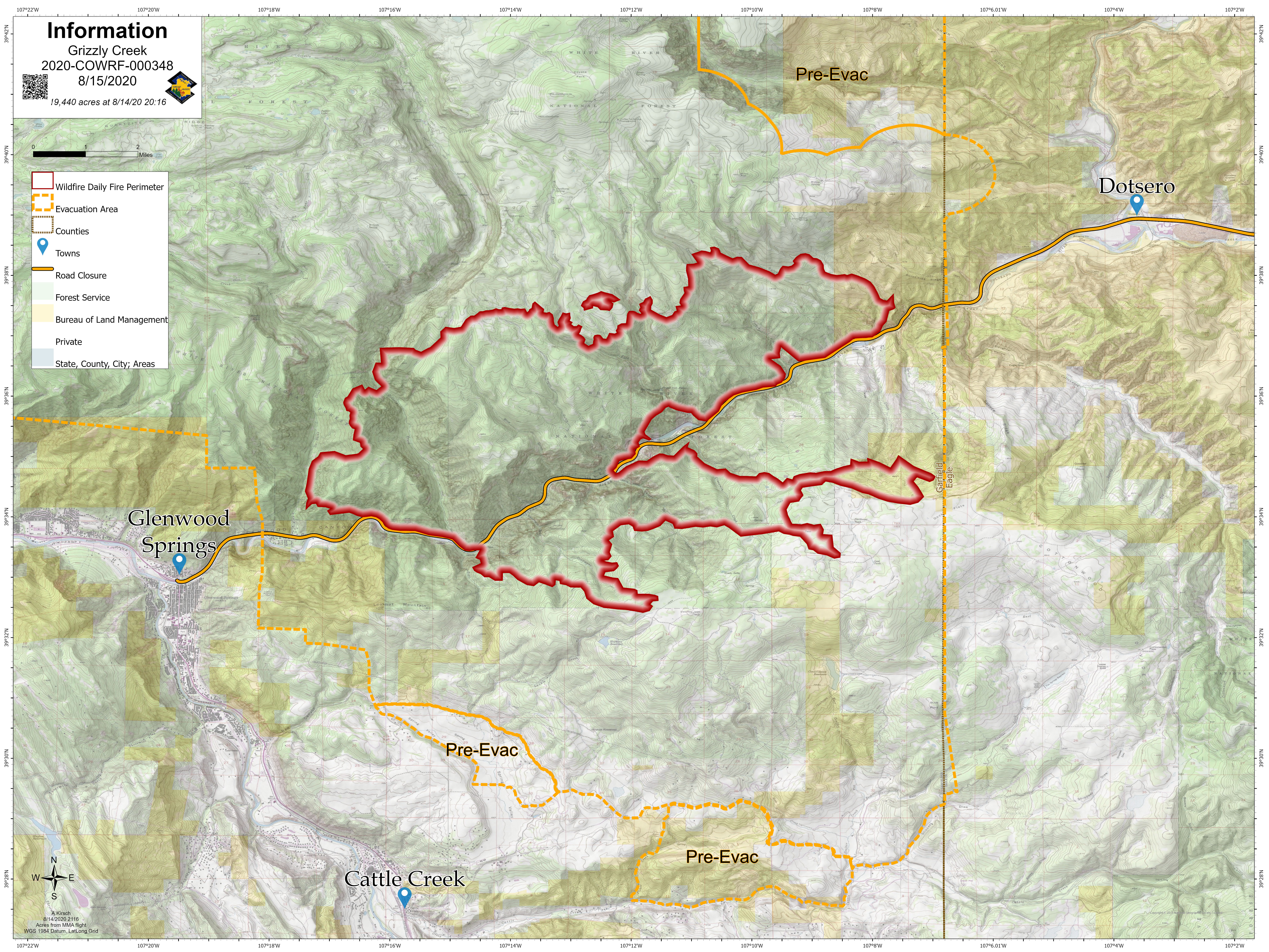
Grizzly Creek Fire – 19,440 acres as of 10 p.m. Aug. 15.
Start Date: Aug. 10
Cause: Under investigation
Location: Glenwood Canyon
Containment:
0%
Resources:
Hand Crews: 15-20 person
Helicopters: 15
Engines: 26
Water Tenders: 2
Dozers, as well as feller bunchers and other logging equipment
Total Personnel: 553
For more information:
InciWeb: https://inciweb.nwcg.gov/incident/6942/
Visit us on Facebook:
https://www.facebook.com/GrizzlyCreekFireCO
Fire Information Line:
(970) 930-1850
Media Line:
(970) 930-1089
Office Hours: 7am-10pm
Current Situation: Yesterday, the winds were favorable and fire lines held in No Name drainage as the fire stayed low in the canyon not spreading across the drainage. On the southeast side, the fire made several runs, but airtankers and firefighters were able to prevent an eastern spread. BLM recreational sites and boat ramps are now closed on the southern portion of the Colorado River Road (RD 301) near Dotsero, Colorado. Specifically, Cottonwood Landing boat ramp, Lyons campground and boat ramp, and Dotsero boat ramp.
Last night the fire became very active west of Bair Ranch and backed under the I-70. The highway will remain closed. Today’s fire weather will be a repeat of yesterday, hot and dry with moderate winds. Firefighting efforts will include structure protection in the areas of Spring Valley, High Aspen and Lookout Mountain, and continue structure protection efforts in the I-70 corridor from No Name to Shoshone Power Station, Bair Ranch and Dostsero. Dozers will assist crews with line construction.
Daily operations video updates will be posted on the Grizzly Creek Fire facebook page. Maps and other information will also be posted on inciweb at https://inciweb.nwcg.gov/incident/6942/.
Evacuations: Residents in communities around the Grizzly Creek Fire should stay aware of the fire’s dynamic changing conditions. Anytime evacuation notices change or areas move into pre-evacuation status, the information will be shared at the Garfield County website at www.Garfield-county.com and Eagle County at www.ecemergency.org, as well as on official FaceBook accounts and local radio stations.
Residents are strongly encouraged to sign up for updates from their respective counties. In Garfield County, go to the Garfield County website and sign up for notifications at garco911.com. For residents of Eagle County, go to www.ecalert.org to sign up for notifications.
Road Closures:
I-70 continues to be closed between Glenwood Springs and Gypsum, with no estimated time for reopening. Forest Service Road 400, Eagle-Thomasville Road, is closed due to excessive traffic and accidents resulting from drivers attempting to use this primarily dirt road as an alternate to the I-70 closure. Cottonwood Pass Road in Garfield and Eagle counties and Independence Pass are closed. Coffee Pot Road, Transfer Trail and Clinetop Mesa roads and areas of the Flattops accessed by those roads are also closed, as well as many surrounding White River National Forest and BLM roads. For more information regarding road closures: www.cotrip.org
Area Closures: BLM recreation sites and boat ramps on the southern portion of the Colorado River Road (RD 301) near Dotsero, Colorado. Specifically, Cottonwood Landing boat ramp, Lyons campground and boat ramp, and Dotsero boat ramp.
Fire Restrictions: Stage 2 Fire Restrictions are in place for all jurisdictions. Information is at https://colorado.gov/pacific/dfpc/fire-restriction-information
Temporary Flight Restrictions (TFR): Temporary flight restrictions are in place for the Grizzly Creek Fire. Flying drones in the area of the fire is illegal, as well as dangerous for the fire pilots.
BLM Recreational Closures on the Colorado RiverGrizzly Creek Fire
Related Incident:
Publication Type: Closures
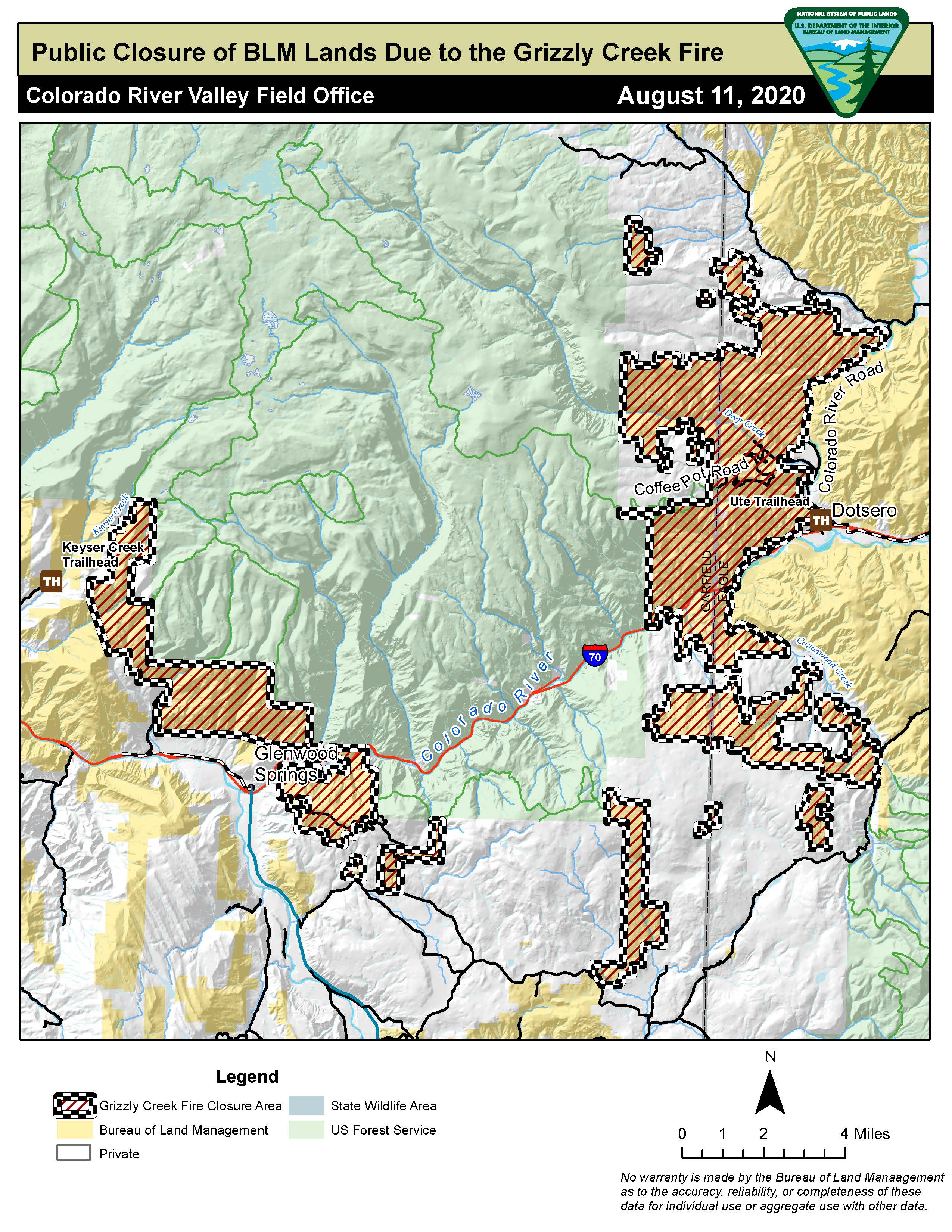
The Bureau of Land Management has announced new closures of recreation sites and boat ramps on the southern part of the Colorado River (RD 301) near Dotsero, Colorado. Specifically the Cottonwood Boat Ramp and the Dotsero Boat Ramp. Closures are due to the Grizzly Creek Fire and the impact it is having on the stretch of river served by these sites. Closure Document Closure Map
New BLM Closures on the Colorado River in Eagle County
Related Incident:
Publication Type: News
The Bureau of Land Management has announced new closures of recreation sites and boat ramps on the southern part of the Colorado River (RD 301) near Dotsero, Colorado. Specifically the Cottonwood Boat Ramp and the Dotsero Boat Ramp. Closures are due to the Grizzly Creek Fire and the impact it is having on the stretch of river served by these sites.
New BLM Recreation Site Closures on the Colorado River
Related Incident:
Publication Type: Announcement
The Bureau of Land Management has announced new closures of recreation sites and boat ramps on the southern part of the Colorado River (RD 301) near Dotsero, Colorado. Specifically the Cottonwood Boat Ramp and the Dotsero Boat Ramp. Closures are due to the Grizzly Creek Fire and the impact it is having on the stretch of river served by these sites. Closure Document Closure Map
Grizzly Creek Fire August 14 2020 Update
Related Incident:
Publication Type: News
Grizzly Creek Fire August 14, 2020 Update
Fire Situation: Grizzly Creek Fire – 13,441 acres as of 10 p.m. Aug. 13.
Start Date: Aug. 10
Cause: Under investigation
Location: Glenwood Canyon
Containment: 1%
Resources: Hand Crews: 13-20 person Helicopters: 18 Engines: 12 Water Tenders: 2 Dozers, as well as feller bunchers and other logging equipment
Total Personnel: 352
For more information: InciWeb: https://inciweb.nwcg.gov/incident/6942/
Visit us on Facebook: https://www.facebook.com/GrizzlyCreekFireCO
Fire Information Line: (970) 930-1850
Media Line: (970) 930-1089 Office Hours: 7am-10pm
Current Situation: Yesterday the fire experienced rapid and erratic growth, challenging firefighters and prompting additional evacuations. The combination of dry vegetation, steep terrain, and the Red Flag conditions of hot, dry weather and gusty winds have continued to drive fire growth.
On Thursday, the fire grew rapidly to the east towards Bair Ranch and southeast up Devil’s Hole Canyon. This resulted in an increase of acreage from 6,251 to 13,441 acres as of 10 p.m. Thursday when the fire was mapped. Firefighters were successful in keeping the fire held in the bottom of the No Name Drainage.
Today the fire will continue to be active as weather conditions remain hot and dry. Firefighting efforts will include structure protection in the areas of Spring Valley, High Aspen and Lookout Mountain, and continued structure protection efforts in the I-70 corridor from No Name to Shoshone Power Station, Bair Ranch and Dotsero.
Helicopters will have access to refill at a portable fire-retardant mixing station and tank, which is being set up on I-70 near No Name. An additional helibase has been established in Glenwood Springs.
Daily operations video updates will be posted on the Grizzly Creek Fire facebook page. Maps and other information will also be posted on inciweb at https://inciweb.nwcg.gov/incident/6942/. The team will host a virtual FaceBook live community meeting tonight, Aug. 14, at 6 p.m.
Evacuations: Residents in communities around the Grizzly Creek Fire should stay aware of the fire’s dynamic changing conditions. Anytime evacuation notices change or areas move into pre-evacuation status, the information will be shared at the Garfield County website at www.Garfield-county.com and Eagle County at ecemergency.org, as well as on official FaceBook accounts and local radio stations.
Residents are strongly encouraged to sign up for updates from their respective counties. In Garfield County, go to the Garfield County website and sign up for notifications at garco911.com. For residents of Eagle County, go to www.ecalert.org to sign up for notifications.
Road Closures: I-70 continues to be closed between Glenwood Springs and Gypsum, with no estimated time for reopening. Forest Service Road 400, Eagle-Thomasville Road, is closed due to excessive traffic and accidents resulting from drivers attempting to use this primarily dirt road as an alternate to the I-70 closure.
Cottonwood Pass Road in Garfield and Eagle counties and Independence Pass are closed. Coffee Pot Road, Transfer Trail and Clinetop Mesa roads and areas of the Flattops accessed by those roads are also closed, as well as many surrounding White River National Forest and BLM roads.
For more information regarding road closures: www.codot.gov/
Closures: White River National Forest and the BLM Grand Junction Field Office Fire
Restrictions: Stage 2 Fire Restrictions are in place for all jurisdictions. Information is at https://colorado.gov/pacific/dfpc/fire-restriction-information
Temporary Flight Restrictions (TFR): Temporary flight restrictions are in place for the Grizzly Creek Fire. Flying drones in the area of the fire is illegal, as well as dangerous for the fire pilots.
Facebook Live Conversation with Fire Managers
Related Incident:
Publication Type: News
Please join us at https://www.facebook.com/GrizzlyCreekFireCO/ tonight (August 16) at 6:00 pm for a Facebook Live Conversation with Fire Managers. Questions will be monitored and answered after the full briefing.
Grizzly Creek Fire grows additional resources arriving
Related Incident:
Publication Type: News
Current Situation: Hot, dry weather combined with dry fuels and a windy afternoon pushed the Grizzly Creek Fire in multiple directions. The fire crossed the Colorado River and Interstate 70 this afternoon, establishing itself on the south side. Within the canyon most of the firefighting effort took place from the air again today. Firefighters are conducting preparation work in the evacuated communities and Shone Power Plant, evaluating structures and helping create defensible space where practical. Firefighters also traveled to the Flattops above the fire, where they scouted for possible containment areas and cleared any campers or other recreationists from the area.
###
Winds and terrain challenge Grizzly Creek Fire efforts
Related Incident:
Publication Type: News
Current Situation: Hot, dry weather combined with dry fuels and a windy afternoon pushed the Grizzly Creek Fire in multiple directions. The fire crossed the Colorado River and Interstate 70 this afternoon, establishing itself on the south side. Within the canyon most of the firefighting effort took place from the air again today. Firefighters are conducting preparation work in the evacuated communities and Shone Power Plant, evaluating structures and helping create defensible space where practical. Firefighters also traveled to the Flattops above the fire, where they scouted for possible containment areas and cleared any campers or other recreationists from the area.
Tomorrow at 6 a.m. the Rocky Mountain Type 2 Incident Management Blue Team will assume command of the fire.
Weather & Fuel Conditions: Hot, dry, windy conditions combined with dry fuels have created extreme fire conditions.
Evacuations and Closures: Cottonwood Pass Road in Eagle and Garfield counties is closed. Interstate 70 remains closed between Glenwood Springs and Gypsum. There is no estimated time for reopening. Visit www.cotrip.org for road closure information. Coffee Pot Road, Transfer Trail and Clinetop Mesa roads are closed, as is much of the BLM and Forest Service lands in those areas. Maps of the closures are available on inciweb.
The community of No Name, Lookout Mountain and Coulter Creek areas east of Glenwood Springs were evacuated today.
Fire Restrictions: All jurisdictions in the area are under Stage 1 fire restrictions and will move to Stage 2 on Thursday.
Grizzly Creek Fire Statistics: Size: 3,200 acresContainment: 0%Total Personnel: 211Aircraft: Two Very Large Air Tankers (VLAT), multiple Large Air Tankers, 4 heavy helicopters, 1 medium helicopterCause: Under InvestigationStart Date: Aug. 10, 2020Location: Glenwood Canyon
Contact Information:InciWeb: https://inciweb.nwcg.gov/incident/6942/Facebook: https://www.facebook.com/GrizzlyCreekFireCO Fire Info Line: (970) 930-1850
BLM Notice of Public Closure
Related Incident:
Publication Type: Closures
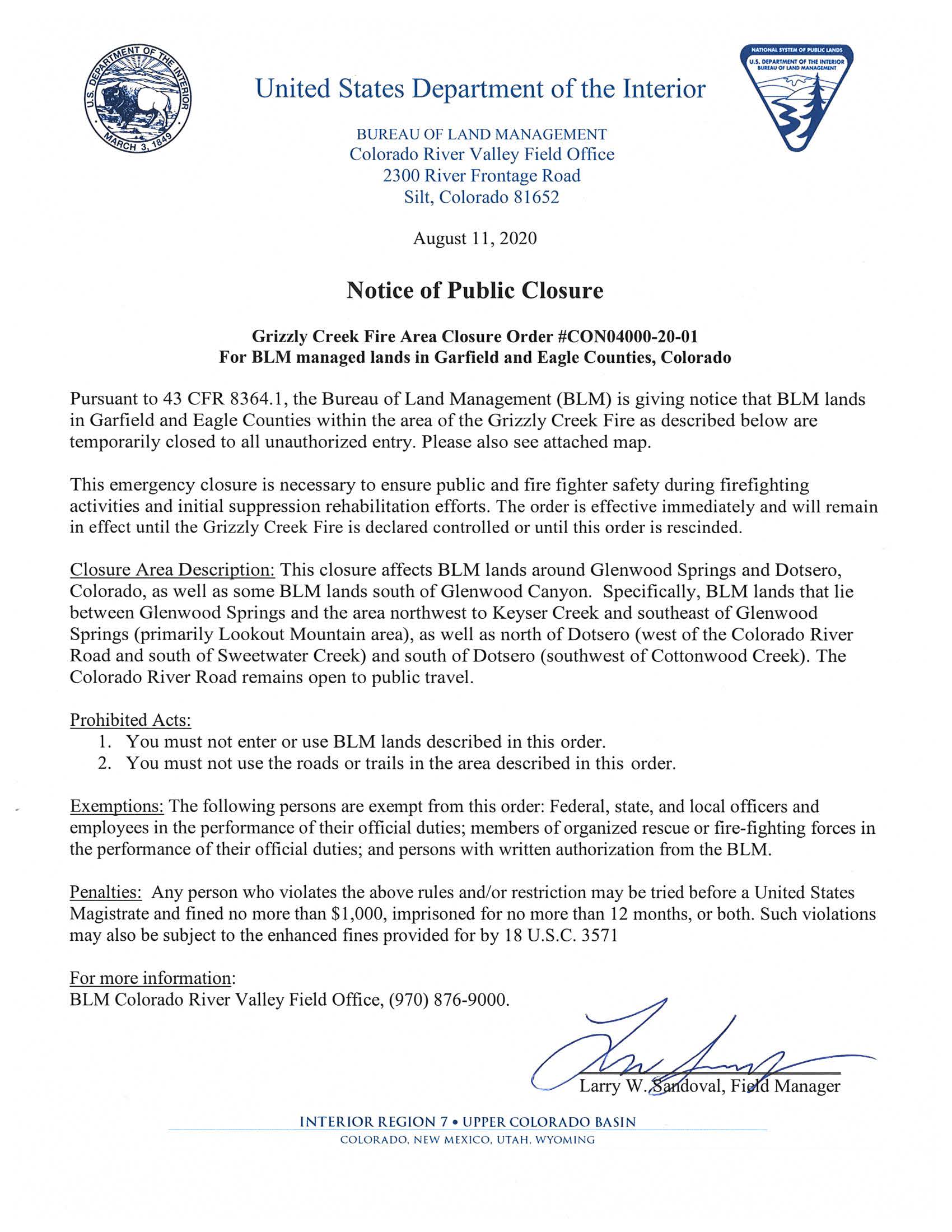
United States Department of the Interior
BUREAU OF LAND MANAGEMENT
Colorado River Valley Field Office
2300 River Frontage Road
Silt, Colorado 81652
August 11, 2020
Notice of Public Closure
Grizzly Creek Fire Area Closure Order #CON04000-20-01
For BLM managed lands in Garfield and Eagle Counties, Colorado
Pursuant to 43 CFR 8364.1, the Bureau of Land Management (BLM) is giving notice that BLM lands in Garfield and Eagle Counties within the area of the Grizzly Creek Fire as described below are temporarily closed to all unauthorized entry. Please also see attached map.
This emergency closure is necessary to ensure public and fire fighter safety during firefighting activities and initial suppression rehabilitation efforts. The order is effective immediately and will remain in effect until the Grizzly Creek Fire is declared controlled or until this order is rescinded.
Closure Area Description: This closure affects BLM lands around Glenwood Springs and Dotsero, Colorado, as well as some BLM lands south of Glenwood Canyon. Specifically, BLM lands that lie between Glenwood Springs and the area northwest to Keyser Creek and southeast of Glenwood Springs (primarily Lookout Mountain area), as well as north of Dotsero (west of the Colorado River Road and south of Sweetwater Creek) and south of Dotsero (southwest of Cottonwood Creek). The Colorado River Road remains open to public travel.
Prohibited Acts:
1. You must not enter or use BLM lands described in this order.
2. You must not use the roads or trails in the area described in this order.
Exemptions: The following persons are exempt from this order: Federal, state, and local officers and employees in the performance of their official duties; members of organized rescue or fire-fighting forces in the performance of their official duties; and persons with written authorization from the BLM.
Penalties: Any person who violates the above rules and/or restriction may be tried before a United States Magistrate and fined no more than $1,000, imprisoned for no more than 12 months, or both. Such violations may also be subject to the enhanced fines provided for by 18 U.S.C. 3571
For more information:BLM Colorado River Valley Field Office, (970) 876-9000.
Larry W. Sandoval
Field Manager