
New Forest Closure in Grizzly Creek Fire area
Related Incident:
Publication Type: News
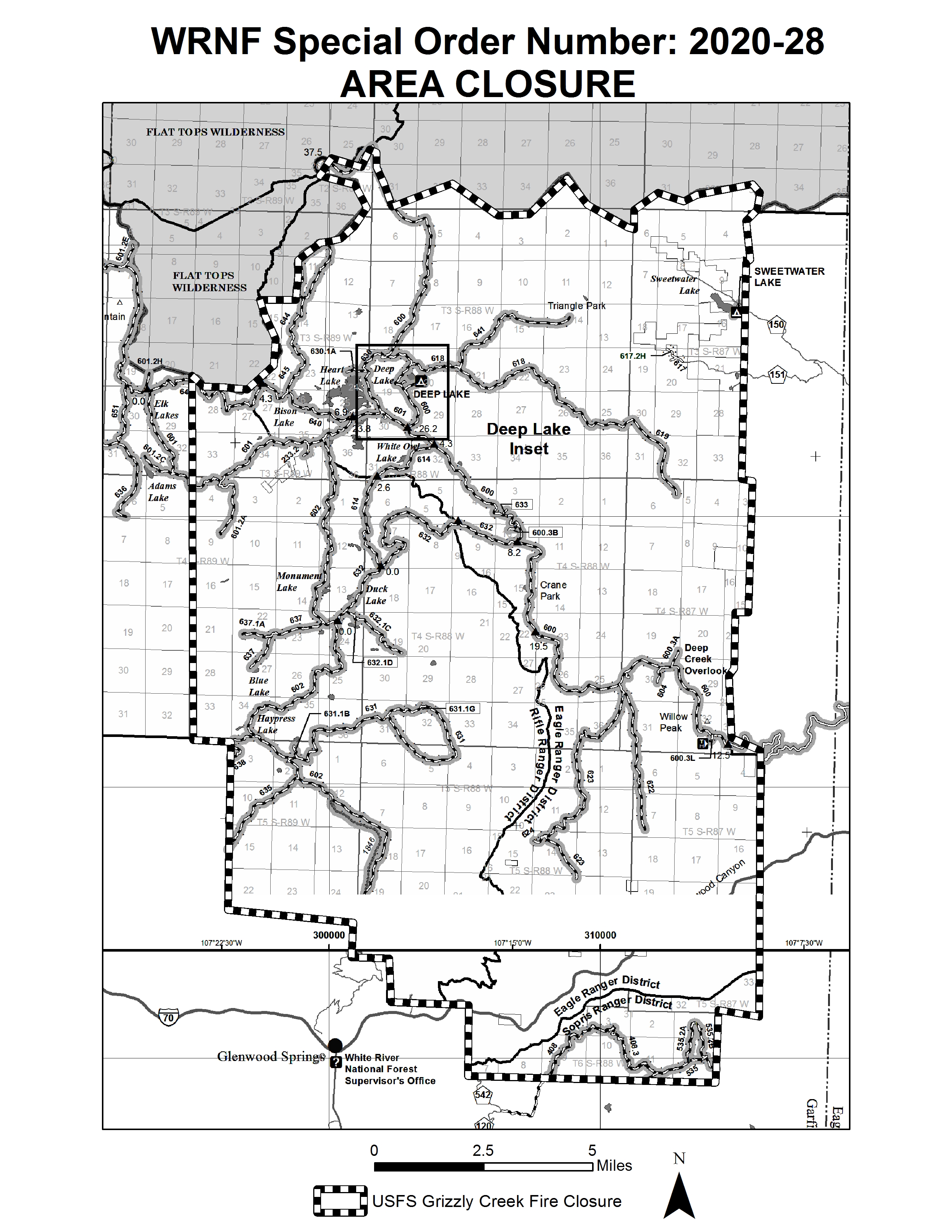
The White River National Forest has a forest closure in place in the area of the Grizzly Creek Fire to protect public safety and prevent interference with firefighting efforts. The closure area is the Forest boundary south of Glenwood Canyon north to the Flat Tops Wilderness boundary. The western boundary of the closure extends to about Adams Lake, and the eastern boundary is the eastern Forest boundary in the Sweetwater/Coffee Pot Road area. Forest road closures include Coffee Pot Road (FSR 600) and Transfer Trail (FSR 602).
New Fire StartRed Canyon Fire 81920
Related Incident:
Publication Type: Announcement
Grizzly Creek Fire resources respond to new start off CR 115
A new start called the Red Canyon Fire broke out just after 4 p.m. Wednesday near Fisher Cemetery Road and County Road 115. The Red Canyon Fire is reportedly 30-40 acres burning in grass and brush. Structures are threatened.
Garfield County issued an evacuation notice for residents south of County Road 115, north of County Road 113, and west of County Road 121. The evacuation center is at Roaring Fork High School.
Type 1 and type 2 helicopters, as well as several single engine airtankers, seven engines and a water tender from the Grizzly Creek Fire is responding and suppressing the fire.
Daily operations video updates will be posted on the Grizzly Creek Fire facebook page. Maps and other information will also be posted on inciweb at https://inciweb.nwcg.gov/incident/6942/.
Evacuations: Please go to Garfield County website at www.Garfield-county.com and Eagle County at www.ecemergency.org, as well as on official Facebook accounts.
Grizzly Creek Fire UpdateSpanish 81920
Related Incident:
Publication Type: News
Incendio Grizzly Creek
Actualización 19 de agosto, 2020
Actividad de ayer: El incendio se mantuvo en el lado este (oriental) del arroyo No Name, y el calor continuaba en la parte más alta del drenaje. Se completó la construcción de dos tercios de la línea indirecta en Transfer Trail hasta Windy Point. En el drenaje de Grizzly Creek, el fuego activo persistía en ambos lados del arroyo. Las líneas alternativas son líneas de defensa secundarias, en caso de que el incendio avance más allá de su perímetro actual. Ayer también prácticamente se terminó una línea alternativa por encima del drenaje del arroyo French Creek.
Los bomberos establecieron una línea de fuego desde la carretera I -70 dirección al norte hasta Coffee Pot Road, y creen que la parte superior de la línea de fuego resistirá. Continuarán mejorando la línea de contención. E n la zona de Bair Ranch, las crestas cercanas a los arroyos Ike y Spruce continúan siendo zonas de foco. Se realizaron operaciones de encendido en Spruce Ridge para despejar combustibles sin quemar junto a la línea de tractores. A medida que el fuego se acerque a Bair Ranch, se implementarán operaciones adicionales para proteger sus estructuras. El fuego progresó mínimamente en las cercanías de Lookout Mountain.
Actividad de hoy: La actividad de supresión del incendio el día de hoy incluirá la finalización de la línea indirecta en la parte más alta de Windy Point, a lo largo de Transfer Trail. Esta es una línea alternativa en caso de que el incendio salga del drenaje del arroyo No Name. Por encima del drenaje de French Creek, el equipo también trabajará para completar líneas de control. Continúan los focos aislados de calor a lo largo de la línea de I-70 dirección al norte hacia Coffee Pot Road. Muchos de los esfuerzos de hoy tendrán lugar en el lado sur de Bair Ranch desde el lado este del arroyo Ike hasta Spruce Ridge, donde continúa siendo elevada la posibilidad de detectar fuego. Excel Energy está trabajando actualmente en Glenwood Canyon al este de No Name para reemplazar postes de electricidad y reparar infraestructura.
Los equipos continuarán combatiendo el incendio donde puedan hacerlo de manera segura, con consideración adicional durante los próximos días por posibles problemas climáticos que incluyen la probabilidad de relámpagos en seco y ráfagas de vientos.
En la página de Facebook del incendio Grizzly Creek se pueden ver videos actualizados de las operaciones diarias. También se pueden ver mapas y otra información por internet en https://inciweb.nwcg.gov/incident/6942/
Evacuaciones: Vaya al sitio web del condado de Garfield www.Garfield-county.com y del condado de Eagle www.ecemergency.org, como también a sus cuentas oficiales de Facebook.
Cierre de caminos:
La I-70 continúa cerrada entre Glenwood Springs y Gypsum, sin fecha estimada de reapertura. Forest Service Road 400, Eagle-Thomasville Road, está cerrado debido al excesivo tráfico y a los accidentes producidos por conductores que intentan utilizar este camino que es mayormente de tierra como alternativa debido al cierre de la I-70. También están cerrados Cottonwood Pass Road en los condados de Eagle y Garfield, los caminos Coffee Pot Road, Transfer Trail y Pinetop Mesa, y las zonas de Flattops a las que se accede por esas rutas, así como también muchos caminos del bosque nacional White River y BLM. Para más información sobre cierre de caminos, visite: www.cotrip.org.
Cierre de áreas: Los sitios recreativos del BLM y las rampas para botes en el lado sur del camino Colorado River Road (RD 301) cerca de Dotsero, Colorado. Específicamente, la rampa para botes de Cottonwood Landing, el campamento y rampa para botes de Lyons, y la rampa para botes de Dotsero.
Restricciones para encendido de fuegos: Las restricciones de Etapa 2 para encendido de fuegos están vigentes en todas las jurisdicciones. https://colorado.gov/pacific/dfpc/fire-restriction-information
Hay una restricción temporaria de vuelos sobre la zona del incendio. Si usted vuela, nosotros no podemos. http://knowbeforeyoufly.org/
Grizzly Creek Fire Update 81920
Related Incident:
Publication Type: News
Grizzly Creek Fire
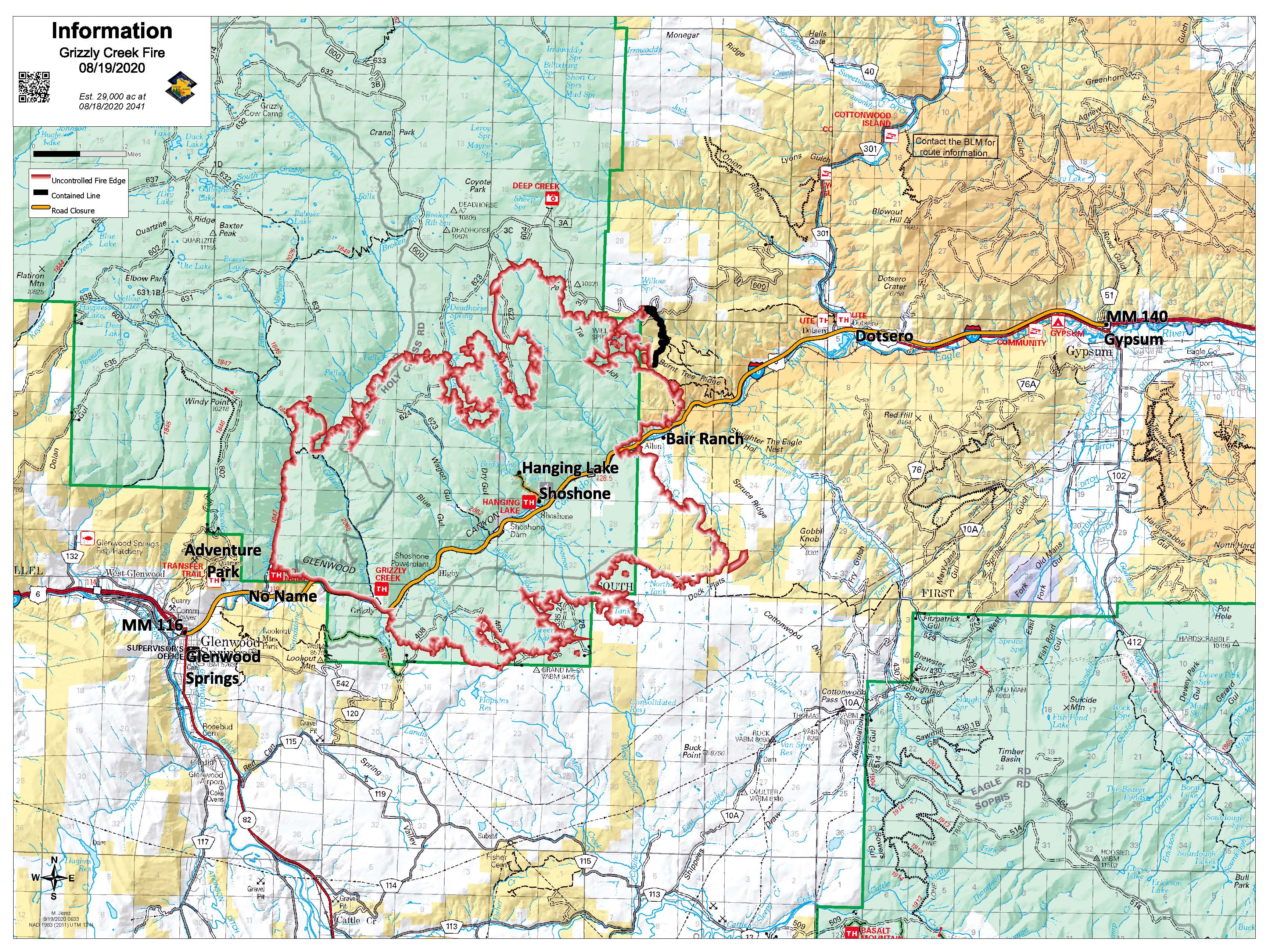
August 19, 2020 Update
Yesterday’s Activity: The fire held in the east side of No Name Creek, with heat remaining at the top of the drainage. Indirect fire line construction on the Transfer Trail was completed two thirds of the way to Windy Point. In the Grizzly Creek drainage, active fire persisted on both sides of the creek. Contingency lines are secondary lines of defense, in the event the fire progresses beyond the current perimeter. A contingency line above the French Creek drainage was also nearly completed yesterday. Firefighters established fire line from I-70 north to Coffee Pot Road and are feeling the upper part of the fire line will hold. They will continue to improve the containment line. The ridges near Ike and Spruce Creeks in the Bair Ranch area are still areas of focus. Firing operations occurred on Spruce Ridge to remove unburned fuels next to the dozer line. As fire becomes close to Bair Ranch, additional fire operations will take place to protect Bair Ranch structures. There was minimal fire progression near Lookout Mountain.
Today’s Activity: Fire suppression activity today will include the completion of indirect fire line to the top of Windy Point, along the Transfer Trail. This line is a contingency line in the event fire moves out of the No Name Creek drainage. Above the French Creek drainage, crew will also work to complete control lines. Scattered pockets of heat remain along the fire line from I-70 north towards Coffee Pot Road. Much of today’s efforts will be on the south side in Bair Ranch from Ike Creek east to Spruce Ridge where fire spotting potential remains high. Excel Energy is currently working in Glenwood Canyon to the east of No Name replacing power poles and repairing infrastructure.
Crews will continue to engage the fire where they safely can, with additional consideration in the next few days of weather concerns, including the potential for dry lightning and gusty winds.
Daily operations video updates will be posted on the Grizzly Creek Fire facebook page. Maps and other information will also be posted on inciweb at https://inciweb.nwcg.gov/incident/6942/.
Road Closures:
I-70 continues to be closed between Glenwood Springs and Gypsum, with no estimated time for reopening. Forest Service Road 400, Eagle-Thomasville Road, is closed due to excessive traffic and accidents resulting from drivers attempting to use this primarily dirt road as an alternate to the I-70 closure. Cottonwood Pass Road in Garfield and Eagle counties. Coffee Pot Road, Transfer Trail and Pine Top Mesa roads and areas of the Flattops accessed by those roads are also closed, as well as many surrounding White River National Forest and BLM roads. For more information regarding road closures: www.cotrip.org
Area Closures: BLM recreation sites and boat ramps on the southern portion of the Colorado River Road (RD 301) near Dotsero, Colorado. Specifically, Cottonwood Landing boat ramp, Lyons campground and boat ramp, and Dotsero boat ramp.
Fire Restrictions: Stage 2 Fire Restrictions are in place for all jurisdictions. https://colorado.gov/pacific/dfpc/fire-restriction-information
A temporary flight restriction is in place over the fire area. If you fly, we can’t http://knowbeforeyoufly.org/
Fire Situation:
Grizzly Creek Fire – 28,030 acres
Start Date: Aug. 10
Location: Glenwood Canyon
Containment: 4%
Resources:
InciWeb: https://inciweb.nwcg.gov/incident/6942/
Twitter: @fire_grizzly
Fire Information Line:
(970) 930-1850
Media Line:
(970) 930-1089
Office Hours: 7am-10pm
Email: 2020.grizzlycreek@firenet.gov
Grizzly Creek Fire UpdateSpanish 81820
Related Incident:
Publication Type: News
Actividad de ayer: Se utilizó equipo pesado en todas las divisiones y se expandieron las líneas de fuego. Mediante una operación de quema controlada, los bomberos trabajaron para despejar combustibles en el lado este (oriental) del drenaje del arroyo No Name con el fin de disminuir la posibilidad de que se expandiera. Más hacia el oeste, continuó la construcción de una línea de fuego alternativa hacia arriba pasando Windy Point. Hubo progreso con líneas de fuego directo e indirecto en el lado este (oriental) del incendio desde I-70 hasta Coffee Pot Road. A pesar del clima favorable, la actividad del incendió aumentó en Spruce Creek y se utilizó retardante para disminuir el avance del fuego en esa zona. La protección de las estructuras estaba en curso en No Name, Bair Ranch, High Aspen y Spring Valley.
Actividad de hoy: Se están comenzando a implementar barreras naturales y líneas de fuego construidas en todas partes donde sea posible a lo largo del perímetro del incendio. La construcción de una línea indirecta de fuego continúa hacia arriba pasando Windy Point, al oeste del arroyo No Name y en el lado sudoeste cerca de Lookout Mountain. A varias divisiones les han llegado equipos manuales adicionales y continuarán estableciendo líneas de fuego. La rama de estructura mantendrá sus esfuerzos en No Name. También tendrán gran presencia en Bair Ramch y zonas del lado sur del incendio, incluyendo Spring Valley y High Aspen. Spruce Ridge será nuevamente una zona de enfoque. Se utilizarán técnicas indirectas y directas en el lado norte del incendio donde los combustibles son más livianos y el terreno más plano ayudará en los esfuerzos.
Esta noche, 18 de agosto, de 6 a 7 p.m., tendremos una reunión comunitaria en vivo mediante Facebook acerca del incendio forestal de Grizzly Creek.
En la página de Facebook del incendio Grizzly Creek se pueden ver videos actualizados de las operaciones diarias. También se pueden ver mapas y otra información por internet en https://inciweb.nwcg.gov/incident/6942/
Evacuaciones: Vaya al sitio web del condado de Garfield www.Garfield-county.com y del condado de Eagle www.ecemergency.org, como también a sus cuentas oficiales de Facebook.
La I-70 continúa cerrada entre Glenwood Springs y Gypsum, sin fecha estimada de reapertura. Forest Service Road 400, Eagle-Thomasville Road, está cerrado debido al excesivo tráfico y a los accidentes producidos por conductores que intentan utilizar este camino que es mayormente de tierra como alternativa debido al cierre de la I-70. También están cerrados Cottonwood Pass Road en los condados de Eagle y Garfield, los caminos Coffee Pot Road, Transfer Trail y Pinetop Mesa, y las zonas de Flattops a las que se accede por esas rutas, así como también muchos caminos del bosque nacional White River y BLM. Para más información sobre cierre de caminos, visite: www.cotrip.org.
Cierre de áreas: Los sitios recreativos del BLM y las rampas para botes en el lado sur del camino Colorado River Road (RD 301) cerca de Dotsero, Colorado. Específicamente, la rampa para botes de Cottonwood Landing, el campamento y rampa para botes de Lyons, y la rampa para botes de Dotsero.
Restricciones para encendido de fuegos: Las restricciones de Etapa 2 para encendido de fuegos están vigentes en todas las jurisdicciones. https://colorado.gov/pacific/dfpc/fire-restriction-information
Hay una restricción temporaria de vuelos sobre la zona del incendio. Si usted vuela, nosotros no podemos. http://knowbeforeyoufly.org/
Grizzly Creek Fire Update 81820
Related Incident:
Publication Type: News
Grizzly Creek Fire
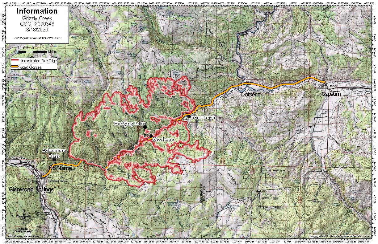
August 18, 2020 Update
Fire Situation:
Grizzly Creek Fire – 27,000 acres, est.
Start Date: Aug. 10
Location: Glenwood Canyon
Containment: 0%
Resources:
Hand Crews: 14
Helicopters: 17
Engines: 43
Water Tenders: 11
Dozers 11
Feller bunchers and other logging equipment
Total Personnel: 712
InciWeb: https://inciweb.nwcg.gov/incident/6942/
Facebook:
https://www.facebook.com/GrizzlyCreekFireCO
Twitter: @fire_grizzly
Fire Information Line:
(970) 930-1850
Media Line:
(970) 930-1089
Office Hours: 7am-10pm
Email: 2020.grizzlycreek@firenet.gov
Yesterday’s Activity: Heavy equipment was utilized across all divisions, and fire lines were expanded. Using a burnout operation, firefighters worked to remove fuels on the east side of the No Name Creek drainage to reduce the chance of fire spreading. Further to the west contingency fire line construction continued up past Windy Point. Progress was made on direct and indirect fire line on the east side of the fire from I-70 to Coffee Pot Road. Despite favorable weather, fire activity increased in Spruce Creek, and fire retardant was utilized to slow fire progression in that area. Structure protection efforts in No Name, Bair Ranch, High Aspen, and Spring Valley were ongoing.
Today’s Activity: Implementation of natural barriers and constructed fire lines is beginning to occur where possible along the fire perimeter. Indirect fire line construction continues up past Windy Point, to the west of No name Creek and on the south west side near Lookout Mountain. Several divisions have had additional hand crews arrive, and they will continue establishing fire lines in their divisions. The structure branch will maintain their efforts in No Name. They will also have a large presence in Bair Ranch and areas on the south side of the fire, including Spring Valley and High Aspen. Spruce Ridge will be an area of focus again today. Indirect and direct tactics will be utilized on the north side of the fire, where lighter fuels and flatter terrain will assist efforts.
A Facebook Live Community Meeting for the Grizzly Creek Fire is planned for this evening, August 18th, from 6pm – 7pm.
Daily operations video updates will be posted on the Grizzly Creek Fire facebook page. Maps and other information will also be posted on inciweb at https://inciweb.nwcg.gov/incident/6942/.
Evacuations: Please go to Garfield County website at www.Garfield-county.com and Eagle County at www.ecemergency.org, as well as on official FaceBook accounts.
Road Closures:
I-70 continues to be closed between Glenwood Springs and Gypsum, with no estimated time for reopening. Forest Service Road 400, Eagle-Thomasville Road, is closed due to excessive traffic and accidents resulting from drivers attempting to use this primarily dirt road as an alternate to the I-70 closure. Cottonwood Pass Road in Garfield and Eagle counties. Coffee Pot Road, Transfer Trail and Pine Top Mesa roads and areas of the Flattops accessed by those roads are also closed, as well as many surrounding White River National Forest and BLM roads. For more information regarding road closures: www.cotrip.org
Area Closures: BLM recreation sites and boat ramps on the southern portion of the Colorado River Road (RD 301) near Dotsero, Colorado. Specifically, Cottonwood Landing boat ramp, Lyons campground and boat ramp, and Dotsero boat ramp.
Fire Restrictions: Stage 2 Fire Restrictions are in place for all jurisdictions. https://colorado.gov/pacific/dfpc/fire-restriction-information
A temporary flight restriction is in place over the fire area. If you fly, we can’t http://knowbeforeyoufly.org/
Community Meeting Tonight
Related Incident:
Publication Type: Announcement
A Facebook Live Community Meeting for the Grizzly Creek Fire is planned for this evening, August 18th, from 6 pm to 7 pm.
Grizzly Creek Fire Update Spanish
Related Incident:
Publication Type: News
Actividad de ayer: Ayer, el clima estaba más favorable lo cual permitió a los bomberos continuar con descargas de agua y gotas retardantes. Las prioridades fueron la creación de líneas de fuego directas e indirectas y la protección adicional de la estructura. Hubo un incendio activo en el drenaje superior del No Name Creek y los recursos se centraron en evitar que los incendios puntuales cruzaran el arroyo. El fuego avanzó en el área de Coffee Pot Road, en un terreno más plano, lo que ayudó a reducir la velocidad del fuego. Los bomberos fueron capaces de atacar directamente el fuego usando apoyo aéreo proporcionando gotas retardantes. La protección de las estructuras estaba en curso en Bair Ranch y No Name, sin pérdida de estructuras.
El fuerte humo al final de la tarde se debió principalmente a que el fuego continuaba quemando combustibles espesos en cañones y barrancos a lo largo del lado norte del fuego.
Actividad de hoy: El clima para los próximos dos días es preocupante, con la posibilidad de tormentas secas. Se espera que continúen las condiciones calurosas y secas con vientos del noreste. Los bomberos reforzarán sus esfuerzos usando equipo pesado en cada división para crear la línea de fuego. La protección de estructuras continuará en No Name y Bair Ranch, con esfuerzos adicionales en High Aspen, Spring Valley y áreas al sur según sea necesario. Las cuadrillas del lado este del fuego trabajarán para completar la creación de la línea de fuego indirecto desde la I-70 hasta el Coffee Pot Road.
Los equipos atacarán el fuego donde puedan hacerlo de forma segura. El ataque directo al fuego sigue siendo difícil, debido a lo accidentado y empinado que es el terreno.
En la página facebook del incendio Grizzly Creek se pueden ver videos actualizados de las operaciones diarias. También se pueden ver mapas y otra información por internet en https://inciweb.nwcg.gov/incident/6942/.
Evacuaciones: Rogamos entrar al sitio web del condado Garfield www.Garfield-county.com y del condado Eagle www.ecemergency.org, como también a sus cuentas oficiales de Facebook.
Cierre de caminos:
La I-70 continúa cerrada entre Glenwood Springs y Gypsum, sin fecha estimada de reapertura. Forest Service Road 400, Eagle-Thomasville Road, está cerrado debido al excesivo tráfico y a los accidentes producidos por conductores que intentan utilizar este camino que es mayormente de tierra como alternativa debido al cierre de la I-70. También están cerrados Cottonwood Pass Road en los condados de Eagle y Garfield, los caminos Coffee Pot Road, Transfer Trail y Clinetop Mesa, y las zonas de Flattops a las que se accede por esas rutas, así como también muchos caminos del bosque nacional White River y BLM. Para más información sobre cierre de caminos, visite: www.cotrip.org.
Area Closures: BLM recreation sites and boat ramps on the southern portion of the Colorado River Road (RD 301) near Dotsero, Colorado. Specifically, Cottonwood Landing boat ramp, Lyons campground and boat ramp, and Dotsero boat ramp.
Restricciones para encendido de fuegos: Las restricciones de Etapa 2 para encendido de fuegos están vigentes en todas las jurisdicciones. https://colorado.gov/pacific/dfpc/fire-restriction-information
Hay una restricción temporaria de vuelos sobre la zona del incendio. Si vuela, nosotros no podemos http://knowbeforeyoufly.org/
Grizzly Creek Fire Expanded Closure
Related Incident:
Publication Type: Closures
The White River National Forest has a closure in place to protect public safety and prevent interference with firefighting operations for the Grizzly Creek Fire, see map. The closure extends from the Forest boundary south of Glenwood Canyon up to the boundary with the Flat Tops Wilderness, extending east to the Forest’s eastern boundary and about as far west as Adams Lake.
Grizzly Creek Fire Update 81720
Related Incident:
Publication Type: News
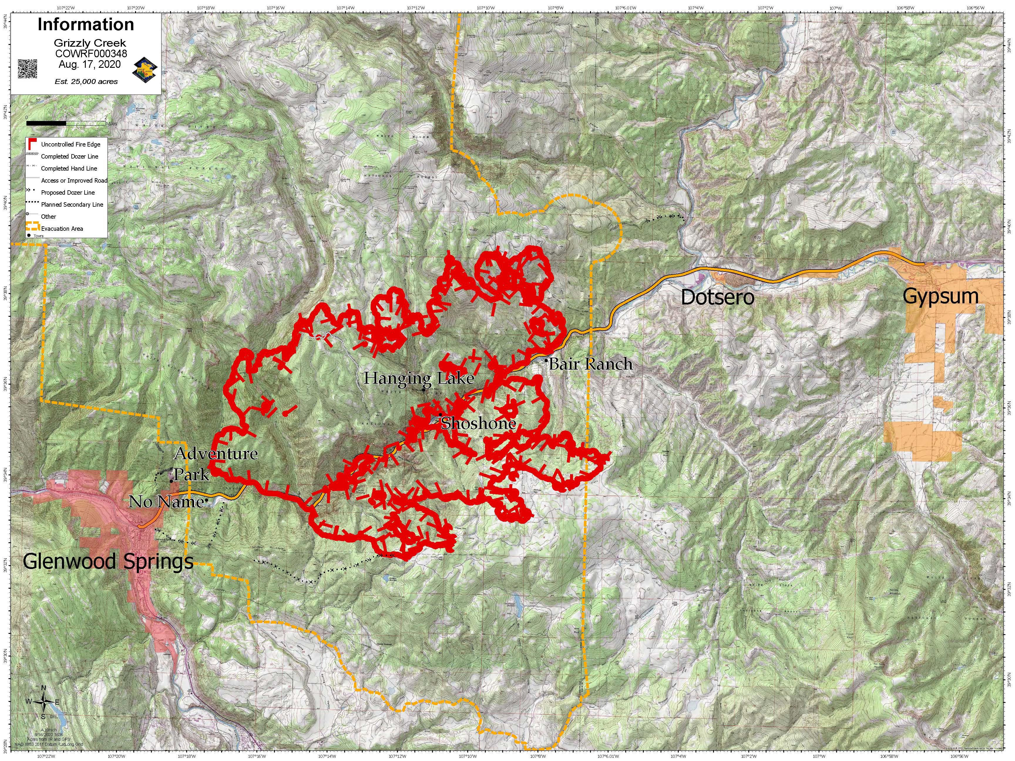
Yesterday’s Activity: Yesterday, more favorable weather allowed firefighters to continue with water and retardant drops. Construction of indirect and direct fire lines and additional structure protection were priorities. There was active fire in the upper No Name Creek drainage and resources focused on preventing spot fires from crossing the creek. The fire advanced in the Coffee Pot Road area, into flatter terrain, which help slow down the fire. Firefighters were able to directly engage the fire using air support providing retardant drops. Structure protection was ongoing in Bair Ranch and No Name, with no loss of structures.
Heavy smoke in the late afternoon was due primarily to the fire continuing to burn thick fuels in canyons and gullies along the north side of the fire.
Today’s Activity: Weather for the next two days is a concern, with the potential for dry thunderstorms. Hot and dry conditions with winds out of the north east are expected to continue. Firefighters will bolster their efforts using heavy equipment in every division to construct fire line. Structure protection will continue in No Name and Bair Ranch, with additional efforts in High Aspen, Spring Valley and areas to the south as needed. Crews on the east side of the fire will work to complete indirect fire line construction from I-70 to the Coffee Pot Road.
Crews will engage the fire where they safely can. Direct attack of the fire continues to be difficult, due to the rugged and steep terrain.
Daily operations video updates will be posted on the Grizzly Creek Fire facebook page. Maps and other information will also be posted on inciweb at https://inciweb.nwcg.gov/incident/6942/.
Evacuations: Please go to Garfield County website at www.Garfield-county.com and Eagle County at www.ecemergency.org, as well as on official FaceBook accounts.
Road Closures:
I-70 continues to be closed between Glenwood Springs and Gypsum, with no estimated time for reopening. Forest Service Road 400, Eagle-Thomasville Road, is closed due to excessive traffic and accidents resulting from drivers attempting to use this primarily dirt road as an alternate to the I-70 closure. Cottonwood Pass Road in Garfield and Eagle counties. Coffee Pot Road, Transfer Trail and Clinetop Mesa roads and areas of the Flattops accessed by those roads are also closed, as well as many surrounding White River National Forest and BLM roads. For more information regarding road closures: www.cotrip.org
Fire Situation:
Grizzly Creek Fire – 25,000 acres, estimated
Start Date: Aug. 10
Location: Glenwood Canyon
Containment: 0%
Resources:
Hand Crews: 12
Helicopters: 17
Engines: 44
Water Tenders: 10
Dozers 5
Feller bunchers and other logging equipment
Total Personnel: 647
InciWeb: https://inciweb.nwcg.gov/incident/6942/
Facebook:
https://www.facebook.com/GrizzlyCreekFireCO
Twitter: @fire_grizzly
For Photos - Flickr: USFSRockyMtns/albums
Fire Information Line:
(970) 930-1850
Media Line:
(970) 930-1089
Office Hours: 7am-10pm
Email: 2020.grizzlycreek@firenet.gov

InciWeb: https://inciweb.nwcg.gov/incident/6942/
Twitter: @fire_grizzly
For Photos - Flickr: USFSRockyMtns/albums
Fire Information Line:
(970) 930-1850
Media Line:
(970) 930-1089
Office Hours: 7am-10pm
Email: 2020.grizzlycreek@firenet.gov
Area Closures: BLM recreation sites and boat ramps on the southern portion of the Colorado River Road (RD 301) near Dotsero, Colorado. Specifically, Cottonwood Landing boat ramp, Lyons campground and boat ramp, and Dotsero boat ramp.
Fire Restrictions: Stage 2 Fire Restrictions are in place for all jurisdictions. https://colorado.gov/pacific/dfpc/fire-restriction-information
A temporary flight restriction is in place over the fire area. If you fly, we can’t http://knowbeforeyoufly.org/