
Phillips Creek Fire Update 08112020
Related Incident:
Publication Type: News
Phillips Creek Fire Update
August 11, 2020 at 9:30 a.m.
Inciweb Address: https://inciweb.nwcg.gov/incident/6935/
Email: 2020.PhillipsCreek@firenet.gov
Start Date: August 5, 2020
Phone: 208-274-9674
Cause: Lightning
Acres: 2,112
Percent Contained: 86%
Personnel Assigned: 414
Current Status: The Phillips Fire is now 86% contained. Due to more accurate mapping, the fire is currently 2,112 acres.
Today, firefighters will monitor completed fireline, implement suppression repair, and be ready to respond to any new starts near the fire area. Suppression repair includes repairing hand line and dozer line by smoothing out the berm on the sides and creating water bars to help prevent erosion.
Camas County will continue work today to replace the bridge on the Soldier Creek Road. The road into the area is closed. An updated Forest Closure Order has reduced the size of the closure area around the fire. Details can be found on the Sawtooth National Forest website https://www.fs.usda.gov/sawtooth.
We ask that the public stay away from the fire area for the safety of the firefighters and the public.
Warmer temperatures are expected on the fire today, with highs in the 80s. Stronger winds are also expected because of a thunderstorm passing southeast of the fire area. Gusts could reach 20 to 25 mph.
A TFR (Temporary Flight Restriction) is in place over the fire area – which means recreational drones and private aircraft cannot fly over the fire. The TFR can be found here: https://tfr.faa.gov/PhillipsCreekFire. Please remember, if
you fly, we can’t.
Fire information can be found on InciWeb at https://inciweb.nwcg.gov/incident/6935/ or on the Sawtooth National Forest website: https://www.fs.usda.gov/sawtooth/. Check out News & Events and ‘Like Us’ on https://www.facebook.com/sawtoothnationalforest , and ‘Follow Us’ on https://twitter.com/sawtoothnf for further information.
Area closure update for the Phillips Creek Fire
Related Incident:
Publication Type: Closures
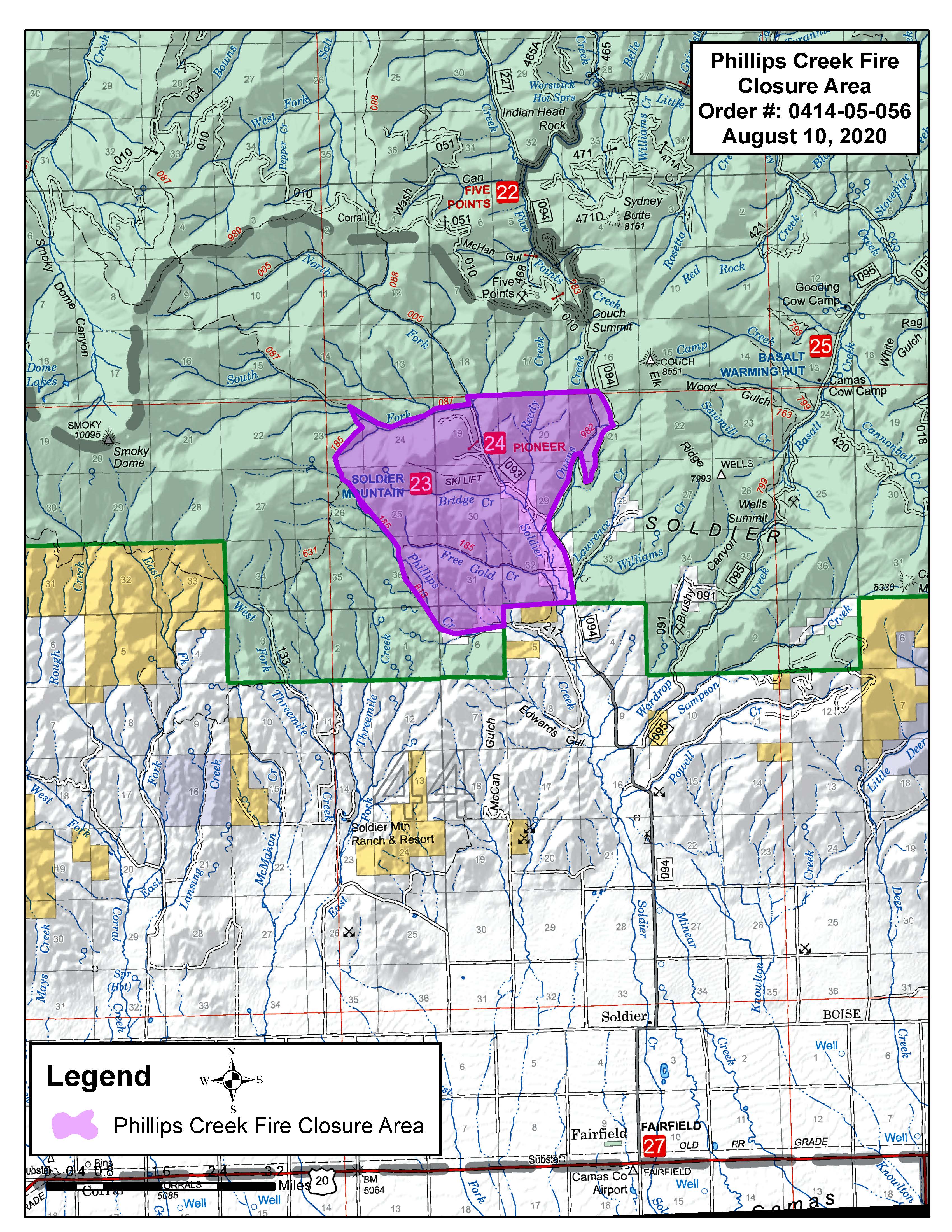
Order Number: 0414-05-056
UNITED STATES DEPARTMENT OF AGRICULTURE FOREST SERVICE SAWTOOTH NATIONAL FOREST FAIRFIELD RANGER DISTRICT
AREA CLOSURE
Phillips Creek Fire – Version #2 For Protection of Public Health and Safety
PROHIBITIONS: Pursuant to Title 36 CFR 261.50 (a) and (b), the following act is prohibited on the National Forest System Lands described in this order, all within the Fairfield Ranger District, Sawtooth National Forest. This order will be in effect when signed and shall remain in effect through October 1, 2020, unless rescinded earlier by the Forest Supervisor. 1. Going into or being upon the Area described below. 36 CFR 261.52(e).
EXEMPTIONS: Pursuant to 36 CFR 261.50 (e) the following persons are exempt from this Order: 1. Persons with a special use authorization or other Forest Service authorization specifically exempting them from the effect of this Order. 2. Any Federal, State, or local officer, or member of an organized rescue or fire fighting force in the performance of an official duty. 3. Federal or State administrative personnel in the performance of an official duty. 4. Private property owners/designee located within closure.
AREA CLOSURE DESCRIPTION The Phillips Creek Fire Area (including all Roads and Trails within the Area) is described as beginning at the Sawtooth National Forest (SNF) boundary and National Forest System (NFS) road #094 (Couch Summit Road), located in Township 1 North, Range 14 East, Section 5; continuing northerly along, but excluding NFS road #094, to the intersection of NFS road #094 and the northern section line of section 21 located in Township 2 North, Range 14 East; continuing west along the northern section line of sections 21, 20, and 19 in Township 2 North, Range 14 East, to the intersection of the northern section line of section 19 and NFS trail #005 located in Township 2 North, Range 14 East, section 19; continuing southernly along but excluding NFS trail #005 to the trail’s beginning at the end of NFS road #093 located in Township 2 North, Range 14 East, section 19; continuing southernly along NFS road #093 but excluding NFS road #093 to the intersection of NFS trail #087 and NFS road #093 Township 2 North, Range 14 East, section 19; continuing westerly along but excluding NFS trail #087 to the intersection of NFS trails #087 and #185 located in Township 2 North, Range 14 East, section 23; continuing southerly along but excluding NFS trail #185 to the intersection of NFS trails #185 and #813 locate in Township 2 North, Range 14 East, section 36; continuing southeasterly along but excluding NFS trail #813 to the intersection of NFS trail #813 and the eastern edge of section 6 in Township 1 North, Range 14 East, section 6; continuing north along the eastern edge of section 6 to the intersection of sections 5 and 6 in Township 1, Range 14 East and sections 31 and 32 in Township 2 North, Range 14 East; continuing east along the northern section line of section 5 in Township 1 North, Range 14 East, to the point of origination on NFS road #094 located at Township 1 North, Range 14 East, section 5.
The described Area, as shown on the attached map, is within the Fairfield Ranger District, Sawtooth National Forest, Camas County, Idaho, Boise Meridian.
PURPOSE: To provide for public safety due to hazards associated with the Phillips Creek Fire, the above described Area is closed to all public entry.
IMPLEMENTATION: 1. This order will be in effect when signed and shall remain in effect through October 1, 2020, unless rescinded earlier by the Forest Supervisor. 2. A map identifying the above-described Area is attached to and made part of this Order. 3. Violation of the above prohibition(s) is punishable by a fine of not more than $5,000.00 for an individual, or $10,000 for an organization, and/or imprisonment for not more than six (6) months. [Title 16 USC 551, Title 18 USC 3571 (b)(6), Title 18 USC 3581 (b)(7).] 4. This Order supersedes any previous Orders/notices for the above-described Area or portions thereof. 5. Further information regarding this Order may be obtained at the Fairfield Ranger Station, Fairfield, Idaho (208-764-3202) or the Sawtooth National Forest Supervisor’s Office in Jerome, ID; telephone number 208-423-7500.
Done at Twin Falls, ID this 10th day of August 2020. ___________________________________ JIM DEMAAGD Forest Supervisor Sawtooth National Forest
Phillips Creek Fire Update 08102020
Related Incident:
Publication Type: News
Phillips Creek Fire Update
August 10, 2020 at 10:30 a.m.
Inciweb Address: https://inciweb.nwcg.gov/incident/6935/
Email: 2020.PhillipsCreek@firenet.gov
Start Date: August 5, 2020
Phone: 208-274-9674
Cause: Lightning
Acres: 2,121
Percent Contained: 7%
Personnel Assigned: 321
Current Status: The Phillips Fire, reported on August 5, is located approximately 8 miles north of Fairfield in the Free Gold Creek drainage. Due to more accurate mapping, the fire is currently 2,121 acres. Firefighters yesterday gained 7% containment. The fire continues to smolder in drainages and draws in timber and patches of aspen.
Structure protection remains a high priority. There is a structure protection group working in Phillips Creek and Free Gold Creek drainage continuing to mop up around structures. Camas County begins work today to replace the bridge on the Soldier Creek Road. The road into the area is closed as well as Couch Summit. A Forest Closure order is in effect for the fire area, and details can be found on the Sawtooth National Forest website https://www.fs.usda.gov/sawtooth.
We ask that the public stay away from the area for the safety of the firefighters and the public.
Today, firefighters:
● continue to secure and improve direct line from Phillips Creek to Bridge Creek,
● on the northeast flank of the fire resources will work to limit continued growth, and
● on the south and southeast flanks crews will continue working to secure and improve the containment line.
Securing and improving the fire line includes “mopping up” or digging out hot, smoldering areas and mixing with cool soil, or water where available, until the area is cool to the touch. Firefighters will also grid from the containment line 50 feet into the fire to find hot or smoldering fuels and extinguish them. They will complete this grid around the perimeter of the fire. This work helps keep hot materials from crossing the containment lines in strong winds and reigniting the fire in unburned grass and brush. The fire is not designated “contained” along a section of fire line until mop up is complete and the firefighters are confident the fire will stay within containment lines.
Continued high afternoon winds and poor relative humidity recovery overnight will continue. A warming trend with winds gusting to 20 mph on the west flank of the fire is expected early in the week.
A TFR (Temporary Flight Restriction) has been implemented over the fire area – which means recreational drones and private aircraft cannot fly over the fire. The TFR can be found here: https://tfr.faa.gov/PhillipsCreekFire. Please remember, if you fly, we can’t.
Fire information can be found on InciWeb at https://inciweb.nwcg.gov/incident/6935/ or on the Sawtooth National Forest website: https://www.fs.usda.gov/sawtooth/. Check out News & Events and ‘Like Us’ on https://www.facebook.com/sawtoothnationalforest , and ‘Follow Us’ on https://twitter.com/sawtoothnf for further information.
Area closure issued due to Phillips Creek Fire
Related Incident:
Publication Type: Closures
Sawtooth National Forest Supervisor James DeMaagd has issued an area closure order for public safety due to hazards associated with the Phillips Creek Fire. A copy of the area closure order and map can be found on the Forest's website https://www.fs.usda.gov/sawtooth.
Phillips Creek Fire Update 08092020
Related Incident:
Publication Type: News
Aug. 9, 2020 at 11:30 a.m.
Inciweb Address: https://inciweb.nwcg.gov/incident/6935/
Email: 2020.PhillipsCreek@firenet.gov
Start Date: Aug. 5, 2020
Phone: 208-274-9674
Cause: Lightning
Acres: 2,149
Percent Contained: 5%
Personnel Assigned: 224
Current Status: The Phillips Fire, reported on Aug. 5, is located about 8 miles north of Fairfield in the Free Gold Creek drainage. The fire is approximately 2,149 acres and 5% Contained. It is burning in brush and timber.
Structures are threatened in the Phillips Creek and Free Gold Creek drainage, as are outbuildings in Soldier Creek Road from Free Gold to the Soldier Mountain Ski Resort. Soldier Mountain Ski Area has postponed the opening of its new bike trail system. There is a structure protection group working in the area today. The road into the area is closed as is Couch Summit.
A Forest Closure order is pending for the fire area. We ask that the public stay away from the area for the safety of the firefighters and the public.
This morning, Great Basin Incident Management Team 3 took command of the fire. The team appreciates all the hard work done by local firefighting resources over the past several days. Team 3 will continue to work with local and Sawtooth National Forest resources to safely and quickly suppress the fire.
Today, firefighters continue to build containment lines:
● on the north and west flanks, crews will begin line construction,
● on the east flank the structure protection group will continue securing around structures, and
● on the south flank crews will continue working to secure and improve the containment line.
Continued high afternoon winds and poor relative humidity overnight will continue through Monday. The low overnight humidity has led to the fire being active throughout the night. Temperatures on the fire will be 80 to 85 degrees with winds gusting to 18 mph.
There are currently five helicopters assigned to the fire. They will be assisting ground firefighting efforts with bucket drops and will be shuttling in a radio repeater today for incident communication.
A TFR (Temporary Flight Restriction) has been implemented over the fire area – which means recreational drones and private aircraft cannot fly over the fire. The TFR can be found here: https://tfr.faa.gov/PhillipsCreekFire. Please remember, if you fly, we can’t.
Fire information can be found on InciWeb at https://inciweb.nwcg.gov/incident/6935/ or on the Sawtooth National Forest website: https://www.fs.usda.gov/sawtooth/. Check out News & Events and ‘Like Us’ on https://www.facebook.com/sawtoothnationalforest, and “Follow Us” on https://twitter.com/sawtoothnf for further information.
Final Silver Highway Fire Update August 9 630 PM
Related Incident:
Publication Type: News
The Silver Highway Fire is 282 acres and 100% contained. This fire will be transferred back to local resources to monitor.
Silver Highway Fire Update August 9 1000 AM
Related Incident:
Publication Type: News
Silver Highway Fire: estimated 400 acres, 50% contained
Location: 17 miles northwest of Robert Lee, Texas
Resources: 21
Last night, resources were requested to assist with the Silver Highway Fire in Coke County. The fire is burning in rough terrain with a grass and brush fuel type. Ground crews immediately began building containment line around the fire. Aviation resources assisted by dropping retardant and water to provide security and slow forward progression.
The fire looks good this morning with minimal smoke observed. Resources plan to continue constructing containment lines today while mopping up and mitigating issues along fireline as needed. Aviation resources will continue to assist today.
Fire Weather: The current hot and dry weather pattern will continue today as well as over the next few days. Breezy conditions will be present across the fire area today with southerly winds at 10-15 mph, gusting near 20 mph this afternoon.
Daily Update 8142020
Related Incident:
Publication Type: News
Fire Information Line: (406) 740-7005
Public Inquiry Email: erin.fryer@usda.gov
Type IV Lincoln Ranger District Incident Commander: Brian McGowan & Don Ihles, Trainee
Facebook - https://www.facebook.com/HLCNF/ | Inciweb - https://inciweb.nwcg.gov/incident/6932/
THIS WILL BE THE LAST DAILY UPDATE, UNLESS CONDITIONS CHANGE
The Fields Gulch Fire was initially observed by Stonewall Lookout on August 6th, 2020. Two helicopters, three Lincoln Ranger District engines, and the Lincoln Volunteer Fire Department responded on the initial attack. The fire is situated in Fields Gulch, some six airmiles south of Lincoln. The terrain is densely timbered, steep, and contains a heavy load of beetle killed fuels.
Size: Approximately 5 acres Containment: 75% Cause: Unknown
Structures threatened: 0 Location: 6 miles south of Lincoln Structures destroyed: 0
Fire Crews: Lincoln Ranger District IA crew
Engines: 3
Current and Planned Operations: Firefighters had another successful day on the Fields Gulch fire yesterday. Crews were able to improve firelines along the perimeter, increasing overall containment. In addition, crews mopped up hotspots interior of the fire by utilizing water from the engines. Today, local crews will continue mop up operations, cold trailing firelines and will begin to move the fire into patrol status. As a warming trend moves into the area over the weekend local firefighters will continue to monitor and patrol the fire watching closely for smoke and extinguishing hot spots as necessary.
Firefighter’s efforts take a great deal of support from the affected community. In this case, the community of Lincoln, their restaurants and motels have been an integral part of the Field Gulch Fire and their sacrifices and efforts are greatly appreciated.
Communities Impacted: Motorists on the Dalton Mountain Road (FS #329) can expect to encounter fire traffic. Residents and the general public are reminded to drive with caution on this road. If fire traffic is encountered, it helps maintain the safety of operations if motorists can pull over and allow fire traffic to pass.
Evacuations and Closures: In order to facilitate the safety of the public and suppression of the Fields Gulch wildfire a temporary closure has been placed on Forest System Road #1829. The closure is in effect for the main #1829 route in Township 13 North, Range 9 West, Sections 25, 26, 27, and 34, Lewis and Clark County. The Type IV team is in close coordination with the Lincoln Volunteer Fire Department, Montana Department of Natural Resources, Lewis and Clark County Sheriff, and Lewis and Clark County Commissioners in the event conditions should change regarding fire closures.
Weather & Fuel Conditions: Weather forecast for today is sunny, with a high of near 77, relative humidity will remain slightly higher at 20 percent in the afternoon hours. Winds will be light from the west southwest at 5 to 10 mph shifting to the west in the afternoon with gusts up to 18 mph. Conditions will remain sunny throughout the weekend with temperatures rising into the upper 80s and low 90s. Fuel conditions consist of heavy timber with extensive dead and down lodgepole intermixed.
Temporary Flight Restrictions: Temporary flight restrictions remain in effect around the entire fire area.
Physical information availability: There are fire information boards posted at the Lincoln Post Office, Lincoln Ranger District, and the top of Stemple Pass. These boards will not be maintained for the Fields Gulch wildlife beginning on Saturday August 15th, unless conditions change.
###Temporary Road Closure for Forest Road 1829
Related Incident:
Publication Type: Closures
UNITED STATES DEPARTMENT OF AGRICULTURE FOREST SERVICE HELENA-LEWIS AND CLARK NATIONAL FOREST LINCOLN RANGER DISTRICT- LINCOLN, MONTANA
FOREST ORDER Forest System Road #1829
Pursuant to 16 U.S.C. § 55 1, 36 C.F.R. § 261.50 (b) and 36 C.F.R. § 261.54 (e), the following acts are prohibited on the Lincoln Ranger District. Helena - Lewis and Clark National Forest.
PROHIBITION:
1. Being on the road. [36 CFR 261.54 (e)]
PURPOSE:
This closure is for public safety due to wild land fire suppression operations associated with the Fields Gulch Fire.
ROAD CLOSURE DESCRIPTION:
The closure applies Forest Service Road #1829 depicted on the attached map (Attachment A), Township 13 North, Range 9 West, Sections 25, 26, 27, and 34, Lewis and Clark County.
IMPLEMENTATION:
This order will be in effect from August 13, 2020, and shall remain in effect until December 31 , 2020, or until the order is rescinded, whichever occurs first.
These prohibitions are in addition to the general prohibitions in 36 CFR Part 261, Subpart A.
EXEMPTIONS:
Pursuant to 36 CFR 261.50(e), the following persons are exempt from this Order:
(1) Any Federal, State, or local officer, or member of an organized rescue or fire fighting force in the performance of an official duty.
Any Federal, State, or local officer, or member of an organized rescue or fire fighting force in the
performance of an official duty. 36 CFR § 261.50(e)(4).
VIOLATION:
Violation of these prohibitions is punishable by a .fine of not more than $5,000 for an individual or $10,000 for an organization, imprisonment for not more than 6 months, or both. (16 U.S.C. 551 and 18 U.S.C. 3559 and 3571).
INFORMATION:
Further information regarding this Order may be obtained at the Lincoln Ranger District Office located at Lincoln, Montana, (406) 362-7000, and at the Helena- Lewis and Clark National Forest Supervisor's Office located at 2880 Skyway Drive, Helena, Montana, 59602, (406) 449-5201.
Executed in Helena, Montana, this 13th day of August, 2020.
William Avey
Forest Supervisor
Daily Update 8132020
Related Incident:
Publication Type: News
Fire Information Line: (406) 740-7005
Public Inquiry Email: erin.fryer@usda.gov
Type IV Lincoln Ranger District Incident Commander: Brian McGowan & Don Ihles, Trainee
Facebook - https://www.facebook.com/HLCNF/ | Inciweb - https://inciweb.nwcg.gov/incident/6932/
The Fields Gulch Fire was initially observed by Stonewall Lookout on August 6th, 2020. Two helicopters, three Lincoln Ranger District engines, and the Lincoln Volunteer Fire Department responded on the initial attack. The fire is situated in Fields Gulch, some six airmiles south of Lincoln. The terrain is densely timbered, steep, and contains a heavy load of beetle killed fuels.
Size: Approximately 5 acres Containment: 50% Cause: Unknown
Structures threatened: 0 Location: 6 miles south of Lincoln Structures destroyed: 0
Fire Crews: Willamette Type 2 Initial Attack (IA) crew, & Lincoln Ranger District IA crew.
Engines: 3 Water Tenders: 1
Current and Planned Operations: Crews improved firelines, yesterday, increasing overall containment of the wildfire to 50 percent. In addition, firefighters extinguished hot spots interior to the fire utilizing both engines and the hose lay system. A local Type IV Incident Management Team took over command of the Fields Gulch fire at the start of shift Thursday morning. Firefighters will take advantage of cooler temperatures and higher relative humidity’s to improve containment lines today. In addition, crews will begin mop up operations both along the perimeter and on hotspots interior to the fire. The Lewis and Clark Interagency Hotshot crew as well as the heavy equipment are being released in order to be available for initial and extended attack operations across the state.
Firefighter’s efforts take a great deal of support from the affected community. In this case, the community of Lincoln, their restaurants and motels have been an integral part of the Field Gulch Fire and their sacrifices and efforts are greatly appreciated.
Communities Impacted: Motorists on the Dalton Mountain Road (FS 329) can expect to encounter a water tender spraying the road to help keep the dust down due to additional traffic. Residents and the general public are reminded to drive with caution on this road. If fire traffic or the water tender are encountered, it helps maintain the safety of operations if motorists can pull over and allow fire traffic to pass.
Evacuations and Closures: At present, there are no evacuations or trail closures. The Type IV team is in close coordination with the Lincoln Volunteer Fire Department, Montana Department of Natural Resources, Lewis and Clark County Sheriff, and Lewis and Clark County Commissioners in the event conditions should change regarding fire closures.
Weather & Fuel Conditions: Weather forecast for today is sunny, with a high of about 73, relative humidity could drop as low as 19 percent in the afternoon hours. Winds will be light from the west to southwest at 8 to 13 mph but gusts could reach as high as 22 mph. Fuel conditions consist of heavy timber with extensive dead and down lodgepole intermixed.
Temporary Flight Restrictions: Temporary flight restrictions (TFR) are in effect around the entire fire area.
Physical information availability: There are fire information boards posted at the Lincoln Post Office, Lincoln Ranger District, and the top of Stemple Pass. These boards are posted daily.
###