
Actualizacin sobre el incendio Park Viernes 30 de agosto de 2024 08 30 2024
Related Incident: Park Fire
Publication Type: News
Actualización sobre el incendio Park: Viernes, 30 de agosto de 2024
Equipo Administrativo de incidentes complejos del área suroeste
EQUIPO 2 - Comandante del incidente John Truett
Tamaño: 429,603 acres
Fecha de Inicio: 24 de Julio de 2024
Contencion: 94%
Personal Total: 1,521
Recursos: 38 camiones, 59 topadoras, 98 camiones de agua, 17 masticadoras, 82 excavadoras, 11 minicargadoras
SITUACIÓN ACTUAL: El Equipo Administrativo de Incidentes (IMT) 6 de CAL FIRE ha estado administrando el esfuerzo de extinción del incendio Park, que afectó tanto a las tierras estatales como al Bosque Nacional Lassen. Hoy a las 7 a.m., el Equipo 6 de CAL FIRE transfirió el mando de las tierras estatales afectadas por el incendio al IMT Tipo 3 local de la Unidad Tehama-Glenn de CAL FIRE. Puede encontrar más información sobre esto en fire.ca.gov/incidents/2024/7/24/park-fire o llamando al 530-529-9233.
El equipo de incidentes complejos del Área Suroeste IMT (CIMT) 2 asumió el mando el viernes por la mañana del área del incendio que se encuentra en las tierras del Bosque Nacional Lassen. El Bosque Nacional Lassen agradece a CAL FIRE por sus exitosos esfuerzos de supresión y colaboración positiva. Si bien las operaciones de extinción y limpieza de incendios ya se han completado en gran medida, aún queda mucho trabajo alrededor del perímetro del incendio. Numerosos recursos, incluidos bomberos y equipo pesado, están asignados al incendio para implementar el plan de reparación y extinción del Bosque Nacional Lassen. La prioridad es proteger y rehabilitar los recursos naturales y culturales, reducir la erosión del suelo y reparar las áreas dañadas por las actividades de extinción de incendios.
El trabajo que están realizando los recursos en el grupo de carreteras consiste en utilizar camiones de agua para reducir el polvo, nivelar carreteras que quedaron dañadas debido al uso intensivo y limpiar alcantarillas obstruidas. El equipo de árboles-peligrosos, formado por equipos de tala de árboles y una gran cantidad de equipo pesado, está trabajando en las carreteras dentro del cierre del bosque. Pedimos al público que observe el cierre (ver más abajo) y no intente acceder a caminos cerrados, lo que permitirá a los bomberos concentrarse en su trabajo y no correr más peligro por el tráfico de vehículos. Los grupos de reparación de supresión están, por ejemplo, reparando kilómetros de cortafuegos construidos con topadoras, actualmente a lo largo de Hogback Road y Ponderosa Way.
COMPORTAMIENTO DEL CLIMA Y DEL INCENDIO: Las condiciones cálidas y secas en todas las elevaciones persistirán durante el fin de semana, pero los vientos seguirán siendo ligeros. Toda la vegetación en las cercanías del incendio está muy seca y no se esperan precipitaciones. El humo de los tocones, los montones de leña y otras fuentes de calor dispersas en el interior del incendio podrían producir humo visible. Sin embargo, estos puntos críticos no representan una amenaza para las líneas de contención.
CIERRES Y RESTRICCIONES DE INCENDIO: Los caminos y senderos del Bosque Nacional Lassen cerca del incendio están cerrados temporalmente según la Orden Forestal No. 06-24-07. Las restricciones contra incendios también están vigentes dentro del Bosque Nacional Lassen según la Orden Forestal No. 06-24-04. Ambas ordenes como la información suplementaria se pueden ver en el sitio web del Bosque Nacional Lassen: fs.usda.gov/alerts/lassen/alerts-notices.
Park Fire Information: 530-414-9298, 8 a.m. – 8 p.m. | 2024.park@firenet.gov
Park Fire InciWeb: inciweb.wildfire.gov/incident-information/calnf-park-fire
Lassen National Forest Facebook:facebook.com/LassenNF
Microwave Tower Fire Area Closure Remains in Effect 08 29 2024
Related Incident: Microwave Tower Fire
Publication Type: Closures
Smoldering hotspots continue to impose hazards to public and firefighter safety
HOOD RIVER, Ore. (August 29, 2024) — The area closure associated with the Microwave Tower fire remains in effect on all National Forest System (NFS) lands within the fire perimeter on the Columbia River Gorge National Scenic Area. Although the fire perimeter is contained, active fire and suppression activities continue. The area closure is expected to remain in place until immediate hazards are mitigated.
The objective of the closure is to proactively protect public and firefighter safety as the Scenic Area continues to extinguish smoldering hot spots within the contained boundary, especially a smoldering historic abandoned disposal site that has been issuing noxious gases and smoke as the contents continue to consume. The disposal site was once used as a place for orchard waste, automobiles and other debris prior to the land becoming Federal lands.
“We are actively working with our partners to safely put out the remaining smoldering areas within the Microwave Tower fire area” said Nicolas Granum, Deputy Forest Supervisor for the Columbia River Gorge National Scenic Area. “We understand this is a unique and popular recreation area and will continue to assess our closure order to get the area open as soon as it is safe to do so. In the meantime, we ask that the public continue to honor the closure.”
A detailed map and description of the Microwave Tower closure area is available at the end of this News Release, on the Scenic Area website and at our office. Closure barriers and signs have been posted on the ground.
Despite cooler temperatures and recent rainfall, fire officials want to remind everyone that the current fire danger rating is VERY HIGH and public use restrictions involving campfires, smoking, and other activities are in effect. We anticipate seeing increased fire activity as temperatures warm and winds continue in the weeks ahead.
For more information regarding Restrictions, please contact:
Columbia River Gorge National Scenic Area:
Information: (541) 308-1700
Twitter: @CRGNSA
For public and firefighter safety, closures are in place for the Historic Columbia River Highway State trail and for roads in Hood River County. Details of these closures are available on their websites at: https://www.hoodrivercounty.gov/closures and https://stateparks.oregon.gov/
Additional information about the Columbia River Gorge National Scenic Area is available at: https://www.fs.usda.gov/crgnsa
Willamette Complex South Daily Update for Friday 08 30 2024
Related Incident: Willamette Complex Fires - South
Publication Type: News
Willamette Complex South Update
Chalk, Coffeepot, McKinley, Moss Mountain, Tire Mountain, 208, and 217 Fires
Online: https://inciweb.wildfire.gov/orwif-willamette-complex-fires-south
Facebook: https://www.facebook.com/WillametteComplexFires/
Email: 2024.willamettecomplex@firenet.gov
Fire Information Line: 541-208-1742
Friday, August 30, 2024
Total Willamette Complex South Personnel: 646
Total Willamette Complex South Acres: 13,091
Resources (Includes Pyramid Fire Resources): 1 Type 1 Hotshot Crews, 9 Type 2 Crews, 3 Type 2 Initial Attack Crew, 4 Helicopters, 16 Engines, 6 Dozers, 124 Heavy Equipment (Masticators, Skid Steers, and Feller Bunchers)
Fire Cause: Lightning
Summary
Heavy fuels continue to retain heat and with the warmer, dryer weather, an increase in fire behavior is likely. Some interior areas have creeping and smoldering fire, and there may be flare-ups and isolated torching where dry fuels are ignited. Infrared flights show widely scattered heat and isolated heat sources across the fires; however, these areas are well inside containment lines, and helicopters are dropping water on these spots. Firefighter and public safety remain the highest priority throughout all phases of the incident.
Chalk Fire (5,700 acres, 66% containment)
Containment lines on the south, east and north portions of the fire will be monitored and improved while lines on the west portion will be deepened from the main body of the fire west along Forest Service Road (FSR) 1912 tying back into FSR 1925.
Moss Mountain Fire (871 acres, 0% containment)
Crews continue to secure areas south of Forest Service Road (FSR) 2120 into the main body of the fire while constructing indirect line along FSR 2120 and 23 to reduce the risk of fire spread. Helicopters are available again today to drop water on hot spots and keep the fire in check. Crews continue to haul and chip woody debris and remove snags.
208 Fire (254 acres, 0% containment)
The 208 Fire is monitored by aircraft, and if necessary, helicopters use bucket drops to keep the fire in check.
217 Fire (38 acres, 100% contained), Tire Mountain Fire (23 acres, 100% contained), McKinley Creek Fire (24 acres, 100% contained), Coffeepot Fire (6,181 acres, 100% contained)
These fires are continually patrolled for flare-ups or heat, and mop-up will continue on the Coffeepot Fire along its north, east and west boundaries. Fire crews are improving contingency lines on the Coffeepot Fire along FSRs 2120 and 2129. Helicopters will drop water on hot spots as necessary to keep the Coffeepot and 208 Fires in check.
Weather and Fire Behavior
Warm temperatures in the upper 80s and low 90s and low humidity continue through Saturday, August 31. A weather system will bring cooler temperatures and higher humidity beginning Sunday and into next week, and a low chance of thunderstorms. Current weather conditions contribute to increased smoldering and creeping that may spread fire in in dry fuels resulting in flare-ups within fire perimeters.
Closures and Fire Restrictions
- For specific closure information, visit tinyurl.com/WillFireClosures2024
- For current fire restrictions, visit tinyurl.com/WillFireRestrictions2024
- Temporary Flight Restrictions (TFR): tfr.faa.gov for up-to-date areas. Wildfires are a no-fly zone for unauthorized aircraft, including drones. For more information, visit knowbeforeyoufly.org.
West Mountain Fires Daily Update 08 30 2024
Related Incident: Boulder FireDollar Fire
Publication Type: News
WEST MOUNTAIN FIRES
Boulder, Snag, Dollar & Goat Fire Updates
QUICK FACTS
Fire Location Size Containment Assigned Crews Inciweb link
Boulder 9 miles SW of Cascade 2,372 acres 57% 336 https://tinyurl.com/ycdfv3tv
Snag 11 miles E of Cascade 28,454 acres 3% 525 https://tinyurl.com/4k9dk3mu
Dollar 18 miles NE of Cascade 3,442 acres 0% 68 https://tinyurl.com/bef6r3tz
Goat 11 miles SE of Cascade 2,580 acres 0% 7 https://tinyurl.com/2h4a3dvr
Cause: Lightning (All Fires) Total Incident Personnel: 936
Weather | Anticipated Fire Behavior:
A high-pressure system passed through the fire area yesterday, bringing warmer temperatures and northwest winds. Resulting fire behavior included active group torching and small isolated runs where wind and terrain align. The high-pressure system remains over the fire area today, bringing stable air with temperatures in the mid-70s with 10 – 15% relative humidity. Minimal winds will result in smoke settling over the area, shading the fires from sunshine and resulting in somewhat less active fire behavior.
- Army crews from the 14th Brigade Engineer Battalion based at Joint Base Lewis McChord are currently assisting with suppression efforts on the West Mountain fires as well as assisting with adjacent wildfires in the area.
- Helicopters have been actively delivering water to all fires and loaning out aircraft to support other area incidents.
Boulder Fire:
- A slight reduction in acreage reflects refined mapping.
- Interior single tree torching occurred yesterday within an island of unburned fuels in the Fawn Creek drainage. This was expected, based on weather conditions, and did not threaten containment.
- Firefighters are mopping up residual heat, securing containment lines, and chipping brush, branches, and other unburned fuels near containment lines, while keeping track of fire activity where heat sources remain.
Dollar Fire:
- Firefighters and Army crews are securing recent firing operations along the western perimeter.
- A wildland fire module has been moved into the Dollar Fire to implement further firing operations along the western edge of the fire, maintain situational awareness on previous burning, and take fuel moisture samples to help predict future fire behavior.
Snag Fire:
- Crews continued firing operations on a strip of green vegetation south of Warm Lake Highway yesterday to reduce the chance of spotting across the roadway. Another firing operation is needed south of the highway along the fire’s northeastern edge. A third firing operation was initiated yesterday on the southern edge along Forest Roads #406 and #409. Several more days of firing is needed to complete these operations.
- Firefighters and Army crews continue holding fire line, mopping up, chipping, and patrolling along the fire’s western flank.
Goat Fire:
- There was active fire behavior along the southwestern edge of the Goat Fire yesterday, showing growth to the southwest.
- Crews continue to improve Forest Service trail 099, cutting back brush, and removing hazard trees for use as a contingency holding feature in case of fire movement in that direction.
Safety Message:
- The influx of holiday weekend visitors and hunters, along with fire responders will bring heavy traffic to local highways, recreation sites, and other areas of the forest. Please use caution so that we can all go home safely.
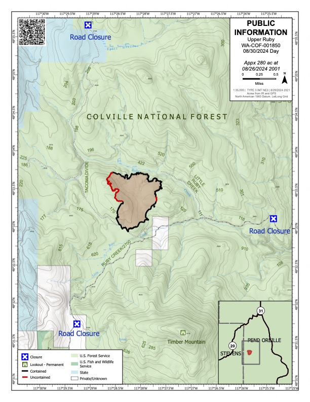
FINAL UPDATE Upper Ruby Fire 08 30 2024
Related Incident:
Publication Type: News
FINAL UPDATE Upper Ruby Fire
August 30, 2024
Quick Facts
Containment: 94%
Fire Perimeter: 280 acres
Initial Start: 08/20/24
Location: Ruby Creek Drainage - approximately 16 miles northwest of Cusick, WA
Hazards: hot ash pits, timber snags, bees, and narrow roads
Values at Risk: Private residences, ongoing timber sales
Cause: Undetermined
Personnel: 186
Structures destroyed: 0 Evacuations: None
Road Closures: Ruby Creek Road (5.5 miles in from Hwy 20), Tacoma Creek Rd (about 11 miles west of Hwy 20), and Tacoma Divide Road (about 4 miles south of Hwy 20)
Ione, WA
PUBLIC AND FIREFIGHTER SAFETY IS THE NUMBER ONE PRIORITY.
Final update for Upper Ruby Fire
The Upper Ruby Fire is in central Pend Oreille County approximately 16 miles northwest of Cusick, WA. It is burning in fuels remaining on the ground following logging activities and in heavily forested areas.
OPERATIONS: Yesterday, 7 crews, 7 engines, 4 water tenders, and 2 pieces of heavy equipment continued mopping up along the fire perimeter to strengthen control lines. This included digging by hand, using hoses to apply water to the ground, and using heavy equipment. Portable handheld infrared technology was used to identify heat near the fire perimeter. Crews continued to mop up around the fire perimeter with containment reaching 94%. Excess resources were released from the incident.
TODAY: Crews will continue to mop up along the fire perimeter and remove firefighting equipment no longer needed. Portable handheld infrared technology will continue to be used to identify heat near the fire perimeter so that crews can work to extinguish those areas. Local resources will be shadowing the current team and will assume command of the fire Saturday morning. Excess resources will continue to be released.
SATURDAY: Local resources will assume command of the fire and will continue to mop up and monitor the fire.
HAZARDS: Hazards to firefighters include hot ash pits, unstable footing, fire-weakened and standing dead trees (snags) and a very high population of ground nesting bees.
WEATHER: Sunny with a high temperature of 82 degrees and winds of 2 to 6 mph. Temperatures over the weekend are expected to be in the high 80’s.
This is the final update.
NE Region IMT3 Team 3, wants to thank the local community for your support during this wildfire.
Inciweb: https://inciweb.wildfire.gov/incident-information/wacof-upper-ruby
Facebook: https://www.facebook.com/newfireinfo
Phone: 509-990-6218 (hours 8 am – 6 pm)

Coffee Pot Fire Update 08 30 2024
Related Incident: Coffee Pot Fire
Publication Type: News
Unified Command: CIIMT5 & CAL FIRE
Fire Size: 6,994 acres
Percent Contained: 3%
Personnel: 1,419
Cause: Lightning
Start Date: Saturday, August 3, 2024, at 10:05 AM
Location: Southeast of Three Rivers, CA
FIRE INFORMATION: Fire information will not be posted on Sequoia and Kings Canyon National Parks Facebook or Instagram pages from Friday through Monday. Fire information will be available on inciweb.wildfire.gov/incident-information/caknp-coffee-pot-fire and videos will continue to be posted on the Park’s YouTube channel at @sequoiaandkingscanyonnps5018. A Public Information Officer will be at the Three Rivers Village Market on Friday and Saturday from 10:30 AM to 4:00 PM to provide fire information and answer questions.
CURRENT SITUATION: The Coffee Pot Fire is 3% contained and about 76% percent of primary control lines have been constructed. Firing operations are continuing along control lines. Overall acreage has increased by 1,311 acres.
Yesterday, the south flank of the fire moved west along the South Fork Kaweah River from the Scratch Creek junction, and north up the east side of the ridge near Bennett Creek. Firefighters continued to hold the direct control line along Scratch Creek. Crews on the western flank worked to slow the rate and intensity of fire spread with back burning. Firefighters also monitored fire activity in the Salt Creek and Lady Bug Groves of giant sequoias. In the north, fire is backing downslope toward Lookout Point and the East Fork Kaweah River. Water-dropping aircraft were used to slow the fire’s spread and intensity. Crews continued brushing along Mineral King Road toward the constructed indirect control line that joins Horse Creek and the East Fork Kaweah River. Fire Use Modules constructed indirect control lines from the containment line at Homers Nose north toward Horse Creek and Mineral King Road.
Today, firefighters' priority is along the western and northern flanks of the fire. Crews are working to hold the direct control line established overnight on the western and southern flanks. Firefighters are improving direct control lines along Scratch Creek and South Fork Drive. To the north, aircraft are using water-drops to slow fire spread toward the East Fork Kaweah River. Brushing is continuing along Mineral King Road. Crews are actively monitoring the intensity of fire in the Lady Bug and Salt Creek Groves of giant sequoias.
EVACUATION NOTICES: An Evacuation ORDER has been issued for zone TLC-E128-B, the area north of South Fork Drive, east of Skyline Drive (Salt Creek, fire control road), south of Skyline Drive (south of Case Mountain and Homers Nose), and west of the Sequoia and Kings Canyon National Park Boundary. An Evacuation WARNING remains in effect for zones TLC-E128-A, TLC-E127-B, and zone TLC-E094-B. For a current list of evacuation orders and warnings, go to: http://protect.genasys.com/
WEATHER: Little change is expected, as high pressure continues to bring warm and dry weather over the area. Skies will be sunny with haze and smoke. Winds will be diurnal and terrain-driven today and into tonight, out of the northeast in the early morning, with southwest winds developing by mid-morning, and gusting over ridges by early afternoon. The inversion will break in the early afternoon. The weather on Saturday will continue to be warm and dry.
SMOKE IMPACTS: The smoke conditions today will be similar to yesterday, with slightly higher concentrations this morning and some relief in the afternoon, as the inversion lifts. The Three Rivers, Hammond, Ash Mountain, and Springville communities will see levels rise to UNHEALTHY with periods of VERY UNHEALTHY by late morning, but will recover to MODERATE in the afternoon before returning to UNHEALTHY overnight. The East Fork Kaweah River drainage will likely see levels reach HAZARDOUS mid-day but will improve to MODERATE overnight. Smoke is also moving into the valley and as far north as Mammoth, but these areas should remain between GOOD and MODERATE today and tonight. For more information on current wildfire smoke impacts in your community, please visit AirNow.gov or fire.airnow.gov.
BLM AND PARK CLOSURES: The portion of South Fork Drive within Sequoia and Kings Canyon National Parks and trails accessed from the road, including the Ladybug and Garfield Grove Trails, are closed. Park closure information is available online at nps.gov/seki. The Bureau of Land Management has also issued a closure of the Case Mountain Extensive Recreation Management Area at blm.gov/press-release.
MINERAL KING FIRE IMPACTS: Recreational access to the Mineral King area of Sequoia National Park will be closed to the public beginning today, August 30. This applies to Mineral King campgrounds, trailheads, and area trails. All other areas of the parks will remain open through the holiday weekend but are likely to be impacted by varying levels of smoke and poor air quality.
PUBLIC NOTICE: Wildfires are a no-fly zone for unauthorized aircraft, including drones. If you fly, we can’t. For more information, visit knowbeforeyoufly.org.
Homestead Complex Fire Update 08 30 2024
Related Incident:
Publication Type: News
Homestead Complex Fire Update for Friday, August 30, 2024
No Man, Salmon 33, Horse Heaven Creek, Bullpup, Fuller Lake, Reynold’s Butte, Lost Bucket
Start date: July 19, 2024 | Location: Northeast of Glide, Oregon | Total Personnel: 810
Total Homestead Complex Fire size: 5,910 acres | Cause: Lightning | Containment: 60%
Summary
The focal point today on the Homestead Complex Fire is to complete the primary and secondary control lines. The objective will be accomplished by mopping up to cool any remaining hot spots, chipping vegetation near these lines, and patrolling to ensure that firelines are secure.
No Man (2,076 acres): The containment plan developed will continue as planned. Chipping operations will continue to strengthen primary and secondary containment lines around the fire. Fire is continuing to hold.
Horse Heaven Creek Fire (2,298 ac.): Fire crews continued with containment and prep work. However, the prep work on the Ridge Road has been completed. Fire behavior is at a minimum. Meanwhile, chipping along roads to the northeast of the fire is progressing according to plan. Hand crews will remain to complete chipping operations.
Bullpup Fire (476 ac.) and Fuller Lake Fire (418 ac.): Suppression repair is ongoing on the Bullpup Fire and it is anticipated that it will take several days to complete. With the current fuels, there is low fire behavior. On the Fuller Lake Fire, line improvement on the 200 and 300 Roads is nearing completion.
Salmon 33 (275 ac.) 100% contained on August 24, 2024.
Reynolds Butte Fire (334 ac): 100% contained on August 22, 2024.
Lost Bucket Fire (34 ac.): 100% contained on July 29, 2024.
Weather: Today will be similar to yesterday with hot and dry conditions. High pressure will continue to build and the temperatures will range from the upper 80’s to lower 90’s. There will be easterly winds with gusts up to 10 mph. However, this afternoon there will be northerly winds. Humidity recovery was poor with some areas of the fire only recovering 30 to 40%.
Closures and Fire Restrictions
The closure order issued by Bureau of Land Management (BLM), Roseburg District, for portions of BLM land which border the Umpqua National Forest Emergency Fire Closure north of Steamboat remains in effect. The closure order can be viewed here: https://www.blm.gov/sites/default/files/docs/2024-07/orwa-fpo-rbg-072624.pdf
The Umpqua National Forest has Emergency Fire Closures in place impacting every district of the forest. https://www.fs.usda.gov/alerts/umpqua/alerts-notices.
The Umpqua National Forest ranger stations will be closed on Monday, September 2, 2024, in observance of Labor Day.
There is a Temporary Flight Restriction (TFR) over the Homestead Complex Fire. Please remember, if you fly we can’t! If a drone or other aircraft enters the air space, all firefighting aviation equipment will be grounded.
Fire Information Line: 541-208-7100 (Staffed 8 a.m. to 8 p.m.)
Park Fire Daily Update 08 30 2024
Related Incident: Park Fire
Publication Type: News
Park Fire Update: Friday, August 30, 2024
Southwest Area Complex Incident Management Team
TEAM 2—Incident Commander John Truett
Size: 429,603 acres
Start Date: July 24, 2024
Containment: 94 percent
Total Personnel: 1,521
Resources: 38 engines, 59 dozers, 98 water tenders, 17 masticators, 82 excavators, 11 skid steers
CURRENT SITUATION: CAL FIRE Incident Management Team (IMT) 6 has been managing the fire-suppression effort of the Park Fire, which impacted both state and Lassen National Forest lands. Today at 7 a.m., CAL FIRE Team 6 transferred command of fire-affected state lands to CAL FIRE Tehama-Glenn Unit’s local Type 3 IMT. Information about can be found at fire.ca.gov/incidents/2024/7/24/park-fire or by calling 530-529-9233.
Southwest Area Complex IMT (CIMT) 2 assumed command Friday morning of the fire area that is on Lassen National Forest lands. Lassen National Forest is grateful to CAL FIRE for their successful suppression efforts and positive collaboration. While fire-suppression and mopup operations have been largely completed, much work around the fire perimeter remains. Numerous resources, including firefighters and heavy equipment, are assigned to the fire to implement the Lassen National Forest’s suppression-repair plan. The priority is to protect and rehabilitate natural and cultural resources, reduce soil erosion, and repair areas damaged by fire-suppression activities.
Work being done by resources in the roads group consists of using water tenders for dust abatement, grading roads that became washboarded with heavy use, and clearing clogged culverts. The hazard-tree group—consisting of tree-felling crews and a lot of heavy equipment—is working off roads within the forest closure. We ask the public to observe the closure (see below) and not attempt to access closed roads, allowing firefighters to focus on their work and not be further endangered by vehicle traffic. The suppression repair groups are, for example, repairing miles of dozer-constructed fireline, currently along Hogback Road and Ponderosa Way.
WEATHER & FIRE BEHAVIOR: Hot, dry conditions at all elevations will persist through the weekend, but winds will remain light. All vegetation in the fire’s vicinity is very dry and no precipitation is expected. Smoke from stump holes, berm piles, and other scattered heat sources in the fire’s interior could produce visible smoke. However, these hotspots do not pose a threat to containment lines.
CLOSURES & FIRE RESTRICTIONS: Lassen National Forest lands, roads, and trails near the fire are temporarily closed under Forest Order No. 06-24-07. Fire restrictions are also in effect within the Lassen National Forest under Forest Order No. 06-24-04. Both orders and supplemental information can be viewed on the Lassen National Forest’s website: fs.usda.gov/alerts/lassen/alerts-notices.
Park Fire Information: 530-414-9298, 8 a.m.–8 p.m. | 2024.park@firenet.gov
Park Fire InciWeb: inciweb.wildfire.gov/incident-information/calnf-park-fire
Lassen National Forest Facebook: facebook.com/LassenNF
Big Hollow Fire Update 08 30 2024
Related Incident:
Publication Type: News
Location: 13 miles west of Grant, MT Start Date: August 23, 2024
Cause: Undetermined Size: 3435 acres Containment: 90%
CURRENT STATUS + PLANNED ACTIONS:
Fire activity continues to be low and is limited to pockets of timber far in the interior away from control lines or features. Yesterday, the fire’s containment percentage increased to 90% after crews successfully continued the mop up process of locating and extinguishing heat by cutting up burning logs and mixing dirt and water into pockets of heat.
Today, containment is expected to increase even more as crews make progress with mop-up on the portions of the fire that haven’t been contained yet. Though, the forward progress of the fire has been stopped and there aren’t many active flames still burning close to control lines, the concern with uncontained edges are spot fires occurring if a section were to flare up or embers being carried outside of the perimeter during a weather event.
With today’s forecasted hot and dry temperatures, interior fire behavior is expected to increase and smoke will be visible as timber patches continue to burn and clean up dead debris on the forest floor making it more accessible for wildlife and assisting with the soil nutrient cycling process.
WEATHER AND FIRE BEHAVIOR:
A ridge of high pressure will be over the region through the weekend causing warm and dry conditions. Today temperatures over the fire area are forecasted to be much hotter than the past couple of days ranging from 76 to 81 degrees. Relative humidities will also drop ranging from 9-14 percent. Winds are expected to be light and variable with an increase to around 15 mph in the afternoon.
EVACUATIONS AND CLOSURES
There are currently no evacuations or closures in place. Fire managers are asking that the public avoids the immediate fire area for both public and firefighter safety.
To learn more about wildfire in Montana and how you can better prepare you, your family, and your home, visit MTFIREINFO.ORG
Diamond Complex and Middle Fork Daily Update 08 30 2024
Related Incident: Middle Fork Fire
Publication Type: News
Our primary mission on the Diamond Complex and Middle Fork Fire is to serve the public diligently. With the safety of the public and our firefighters in mind, we are committed to addressing the needs and concerns of your communities by managing and controlling the fires to keep your forests, parks, and natural areas safe and enjoyable. Utilizing safe, yet effective firefighting suppression methods, our goal is to help you return to enjoying the outdoors.
Transfer of command of the Diamond Complex and Middle Fork Fire from California Interagency Incident Management Team 4 to Southern Area Gold 3 Incident Management Team will occur at 7:00 a.m. Saturday.
The Diamond Complex in the Umpqua National Forest consists of 32 fires totaling approximately 11,152 acres and is 77 percent contained. Thirty of the 32 fires in the Diamond Complex are now 100 percent contained.
The Middle Fork Fire in the northwest corner of Crater Lake National Park is 5,281 acres and is 42 percent contained. The fire is primarily burning within the 2015 National Creek and 2017 Spruce Lake fire scars. Throughout the fire area there is an extreme hazard to firefighters due to falling dead standing trees remaining from the 2015 and 2017 fires.
Containment of the Diamond Complex increased to 77 percent, one percent higher than yesterday. Hotter, drier weather is leading to a slight increase in fire activity of internal fuels. There has been no growth to the fire’s perimeter, but some fuels have ignited near the fire’s perimeter. Crews continue to implement direct and indirect strategies, utilizing natural barriers where appropriate. Fire crews continue to patrol and mop-up, locating and extinguishing areas of residual heat to the extent necessary on the fire edges. An initial attack group, comprised of hand crews, engines, dozers, water tenders, falling modules, and task force leaders are in place to swiftly respond if there any new fire starts. Excess equipment is being backhauled and relocated as needed.
OPERATIONS:
Middle Fork Fire: (5,281 acres, 42% contained):
Crews continue to construct direct fireline using minimally invasive suppression tactics (MIST) and are making forward progress. Crews continue to remove hazard trees for firefighter safety along the 230 Road and along the North Entrance Road. The north entrance to Crater Lake National Park remains closed. Infrared monitoring identified limited spread. The park remains open.
Diamond Complex Fires:
Pine Bench Fire (North of Hwy 138 near Dry Creek, 3,990 acres, 65% contained):
The fire perimeter and containment level remain the same as yesterday. Crews will be patrolling and mopping up on the fire’s edge on the west, south, and east sides. On the north side of the fire, in the Boulder Creek Wilderness, crews will scout the area where safe to do so and direct aircraft to areas of heat. This area is extremely steep terrain and difficult in areas for firefighters to engage directly.
Potter Fire (North of Hwy 138, two miles southeast of Potter Mountain, 3,416 acres, 38% contained):
On the eastern and northern side, firefighters continue to mop up and eliminate hot spots. On the southern perimeter, firefighters will continue to construct direct and indirect line.
WEATHER AND FIRE BEHAVIOR:
Weather continues to be a concern as very dry conditions persist over the area. Relative humidities fell into the mid-teens yesterday, while temperatures rose to the mid 80’s to low 90s. Dry conditions will remain in place today and tomorrow, with possible thunderstorms with dry lightning Sunday and Monday. Winds will remain variable today before northeast winds become dominant at the end of the day.
SMOKE OUTLOOK:
For the most up to date information, please visit fire.airnow.gov/
EVACUATIONS:
None. As of August 23, 2024, the Douglas County Sheriff’s Office has lifted evacuation orders for all areas.
FOREST CLOSURE:
Please note that all Umpqua National Forest Ranger Stations are closed on Monday, Sept 2 in observance of Labor Day.
On August 27, 2024 the Forest issued an updated closure order, allowing increased access to specific roads, trails, and campgrounds that are listed as exemptions in Forest Order 06-15-24-07. For more information visit the Umpqua National Forest website at: https://www.fs.usda.gov/alerts/umpqua/alerts-notices/?aid=88996.
The Rogue River-Siskiyou National Forest has issued a closure for the area north and west of Crater Lake National Forest along Highway 230 south to the intersection with Highway 62. See the Closure Order and map at https://www.fs.usda.gov/alerts/rogue-siskiyou/alerts-notices.
PARK CLOSURE:
The North Entrance Road is closed from North Junction to the park boundary at the junction with Highway 138, until Saturday. It will remain open over the holiday weekend and close again on Tuesday, September 3rd. Expect busier than usual traffic at both park entrances. Crater Lake National Park has several closures in effect, closure orders and maps can be found at: https://www.nps.gov/crla/learn/news/temporary-closure-of-north-entrance-road-continues.htm
Long lines and waits of up to 2 hours should be expected throughout the holiday weekend at both entrance stations. The South Entrance Station will be especially busy on Friday, August 30th, as it will be the only entrance into the park. Arriving before 10:00 AM or after 3:00 PM may reduce wait times. If the park is not your destination, please consider avoiding Highway 62 and taking an alternative route. Please be advised that fire operations may necessitate temporary closures or delays along the North Entrance Road at any time.
Beginning at 6:00 AM Tuesday, September 3rd, and continuing until further notice, the North Entrance will again be closed to all traffic to allow for hazard reduction work related to the Middle Fork Fire to resume. During this time, access to the park will be limited to the South Entrance. We recommend checking the latest conditions and road status before your visit to ensure a smooth and enjoyable experience. Updates will be available on the park website at www.nps.gov/crla and on Oregon Tripcheck at www.tripcheck.com.\
REMINDER: The Pacific Crest Trail between the Lightning Springs and Rim Trail Intersections, Bald Crater Loop, Bert Creek and Boundary Springs Trails are closed until further notice due to potentially hazardous conditions created by the Middle Fork Fire. Hikers and bikers may not use the North Entrance Road to enter or leave Crater Lake National Park.