
Sharrott Creek Fire Closure Order 08 30 2024
Related Incident:
Publication Type: Closures
PURPOSE
The purpose of this order is for public health and safety due to fire activity and related suppression activities on the Sharrott Creek fire.
DESCRIBED AREA (Exhibit A)
All NFS Lands on the Stevensville Ranger District of the Bitterroot National Forest in the area
bounded by the Sweathouse Creek trail #121 and the Forest boundary West along trail #121 into
the Selway-Bitterroot Wilderness to the headwaters of Sweathouse Creek following the western
spur of the ridge to Sky Pilot Peak; head North following the Western boundary of the Bitterroot
National Forest to an unnamed peak at the headwaters of South Fork Sweeney Creek; head North
and East following South Fork Sweeney Creek to the confluence with Sweeney Creek; then East
following Sweeney Creek to the Forest Boundary; head South following the Forest Boundary for
about 500 feet South to an unnamed stream in section 20, follow the unnamed stream West to
Sweeney Viewpoint trail #399, follow to the junction of Larry Creek Trail #129; follow trail
#129 South to a close road which leads to FS road #1316; follow FS road #1316 to its junction
with Bass Creek Trail #4 then South to Bass Creek; head East along Bass Creek to the Forest
Boundary; then follow the Forest Boundary South to Sweathouse Creek trail #121.
CLOSED TRAILS (Exhibit A)
1. Little St. Joe, National Forest System Trail #392 From milepost 0.00 at its junction with NFSR #1136 to its terminus.
2. Bass Creek, National Forest System Trail #4 from milepost 0.00 at its junction with NFSR #1136 to its terminus.
3. Lappi Lake, National Forest System Trail #324 where it intersects Trail #4 to its terminus.
4. Kootenai Creek, National Forest System Trail #53 from milepost 0.00 at its junction with NFSR #1322 to its terminus at the junction with South Kootenai Lake trail #302.
5. Kootenai Lakes, National Forest System Trail #302 from milepost 0.00 at its junction with National Forest System Trail #53 to its terminus.
6. St. Mary Peak, National Forest System Trail #116 from milepost 0.00 at its junction with NFSR #739 to its terminus.
7. Big Creek, National Forest System Trail #11 from milepost 0.00 at its junction with NFSR #736 to its terminus.
8. South Fork Big Creek, National Forest System Trail #118 at its junction with trail #11 to its terminus.
9. Big Creek Divide, National Forest System Trail #306 at its junction with trail #11 to its terminus.
10. Glen Lake, National Forest System Trail #232 from milepost 0.00 at its junction with NFSR #1321 to its terminus.
11. Sweathouse Creek, National Forest System Trail #121 from milepost 0.1 at the Forest Boundary to its terminus.
IMPLEMENTATION:
This Order shall be in effect from August 30, 2024, at 0600 until rescinded or until October 31, 2024, at 0001, whichever occurs first.
For a digital version of this Order and Exhibit A, go to https://www.fs.usda.gov/bitterroot
Evacuation Orders Reduced for Some Areas 08 30 2024
Related Incident:
Publication Type: Announcement
Per the Boise County Sheriff's Office this afternoon:
- Lightning Creek area is now reduced from a Level 2 down to a Level 1.
- Danskin and Gallagher Creek area is now reduced from a Level 3 to a Level 1.
- Southfork Road and area is no longer under any preparedness level.
Wye and Surprise Fires Closure Order 01170624001 08 30 2024
Related Incident:
Publication Type: Closures
U.S. Department of Agriculture, U.S. Forest Service
Nez Perce-Clearwater National Forest
Lochsa Powell Ranger District
Moose Creek Ranger District
Trail Closure
PROHIBITIONS
Pursuant to 16 U.S.C. § 551 and 36 C.F.R. § 261.50 (b) the following are prohibited on the National Forest System (NFS) trails in the Lochsa Powell and Moose Creek Ranger Districts, Nez Perce-Clearwater National Forests, described below and shown on the attached map incorporated into this Order as Exhibit A the Described Trails:
1. Being on the trail. 36 C.F.R. § 261.55(a).
EXEMPTIONS
Pursuant to 36 C.F.R. § 261.50(e), the following persons are exempt from this Order:
1. Persons with Forest Service Permit No. FS-7700-48 (Permit for Use of Roads, Trails, or Areas Restricted by Regulation or Order), specifically exempting them from this Order or a written determination by a Forest Service authorized officer that a permit is not required under 36 C.F.R. § 251.50(e)(1) or (2).
2. Any Federal, State, or Local Officer, or member of an organized rescue or firefighting resource in the performance of an official duty.
3. Owners or Lessees of land in the Described Area or those who needs to use the Described Roads and Trails to access land they own or lease.
DESCRIBED TRAILS
The Described Trails are entirely within Idaho County, Idaho and includes all NFS lands within the following boundaries:
Closed trails segments:
Trail # 559 (Spruce Creek Trail) from Bear Creek Pass (Idaho/Montana boarder) at the top of Lost Horse Road to its junction with Trail # 522 (Paradise Creek Trail);
FS Trail # 421 (East Moose Creek Trail) from Moose Creek Ranger Station to its junction with Trail # 486 (Cedar-Moose Creek Trail) between Dolph and Cedar Creeks southwest of Elk Summit;
Trail # 619 (Bailey Mountain Trail) from the junction of Trail # 421 to its junction with Trail # 618;
Trail # 618 (North Moose/Issac Lake Trail) from the junction of Trail # 421 to its junction with Trail # 939 (Maple Lake Lookout Trail);
Trail # 939 (Maple Lake Lookout Trail) from junction with # 618 to its junction with # 486 (Cedar-Moose Trail);
Trail # 486 (Cedar-Moose Creek Trail) from Elk Summit Trailhead (FS Road #360) to its junction with # 421;
Trail # 442 (Double Creek Ridge Trail) from the junction of Trail # 421 to its junction with Trail # 618;
Trail # 427 (Trout Peak Trail) from the junction with trail # 421 to the junction with Trail # 430 (Lost Horse Trail);
Trail # 624 (Monument Creek Trail) from the junction of Trail # 421 to its junction with Trail # 430;
Trail # 432 (Battle Ridge Trail) from the junction of Trail # 421 to its junction with Trail # 462 (Battle Ridge Crossover);
Trail # 464 (Goat Heaven Trail) from the junction of Trail # 421 to its junction with # 491.
Trail # 491 (Gateway Peak Trail) from the junction of Trail # 421 to its junction with Trail # 462.
Trail #693 (Big Rock Trail) from junction of Trail # 4 to its junction with Trail # 458
Trail #458 (Meeker Ridge Trail) from junction of Trail # 4 to its junction with Trail # 693
Trail #447 (Halfway Creek Trail) from junction with Trail # 4 to its junction with # 693
Trail #444 (Goat Mountain Trail) from junction with Trail # 4 to its junction with # 693
The total mileage of trails within this closure order is 98 miles.
The closed Trails are shown on the attached map and closed to all uses.
PURPOSE
The purpose of this order is to protect public health and safety due to active wildfire in the area.
IMPLEMENTATION
1. This Order shall be in effect from August 30, 2024 at 12:00 a.m. through October 09 at 06:00 a.m, unless rescinded.
2. A map identifying the Described Trails is attached and made part of this Order as Exhibit A. For a digital version of this Order and Exhibit A, go to https://www.fs.usda.gov/alerts/nezperceclearwater/alerts-notices.
3. Unless otherwise expressly defined in this Order, the terms used in this Order are defined by the regulations of the Secretary of Agriculture, 36 C.F.R. Chapter II, Parts 200-299. If there are terms in this Order that are not expressly defined in the Order or 36 C.F.R. Chapter II, Parts 200-299, their meaning shall be determined by their plain language definitions.
4. A violation of the above prohibitions is punishable as a Class B misdemeanor by a fine of not more than $5,000 for individuals and $10,000 for organizations, or by imprisonment for not more than six months, or both. 16 U.S.C. § 551; 18 U.S.C.
§§ 3559, 3571, and 3581.
5. Contact the Moose Creek Ranger District in Kooskia, ID (208) 926-4258, or Nez Perce-Clearwater National Forest Supervisor’s Office in Kamiah, ID, (208) 935-2513, for more information about this Order.
6. This Order supersedes any previous Orders prohibiting the same or similar acts on the same Described Trails.
Signed and issued on August 30, 2024
8302024 Operations Video 08 30 2024
Related Incident: Park Fire
Publication Type: Announcement
Click on the following link to watch today's operational video...
Coffee Pot Fire Evacuation Update 08 31 2024
Related Incident: Coffee Pot Fire
Publication Type: Announcement
Today, August 31, 2024 at 2:50p.m., Sheriff Boudreaux has issued an Evacuation Order, due to a planned firing operation, for Genasys Zone TLC-E094-D, the area South of the East Fork of the Kaweah River (approximately ½ mile southeast of Oak Grove, just below mineral King Road, and follows the river east to the southern border of the zone. The Southern and West boarders do not have a distinguishing landmark. Please refer to the Genesys website for a more detailed zone and area description: protect.genasys.com. (https://protect.genasys.com/)
Sheriff Boudreaux has also issued an Evacuation Warning for Genasys Zone TLC-E095, the area along Mineral King Road EAST of the National Park Boundary, to include all communities east of that point, Cabin Cove, Silver City and Mineral King. This Warning has been issued due to potential impacts of Mineral King Road. Road impacts can consist of delays, closures and pilot vehicle operations at any time due to fire conditions. Should fire impact roadway, a road closure up to 48 hours or more could lead to an ORDER or a possible shelter in place ORDER. Please plan accordingly if you have medical concerns or needs. NOTE this is for Mineral King roadway impact conditions, the fire is currently NOT immediately threatening any of these communities. Please refer to the Genesys website for a more detailed zone and area description: protect.genasys.com. (https://protect.genasys.com/)
For additional fire and closure information, please call the Incident Public Information office at 559-492-9988 or refer to http://inciweb.wildfire.gov/inciden.../caknp-coffee-pot-fire (https://inciweb.wildfire.gov/incide.../caknp-coffee-pot-fire).
Property owners for the Homestead Iron Creek Crooked Creek Goat Way and Cow Camp Areas Allowed Temporary Access Saturday Morning 08 31 2024
Related Incident:
Publication Type: Announcement
The Custer County Sheriff is going to try to get some residents into their properties on Saturday morning, August 31. Please carefully follow the instructions.
Emergency Services will be providing an escort for property owners on Saturday, August 31, 2024. All property owners for the Homestead, Iron Creek, Crooked Creek, Goat Way, and Cow Camp Areas will have to bring identification and sign in at the Emergency Operation Office located behind City Hall between 7:00 am and 8:00 a.m.
Once you have been issued a pass, you will proceed to the road block. At 8:30 sharp there will be one escort into the area. Everyone must get in and get out as all passes must be returned to the road block attendant by 11:00 a.m.
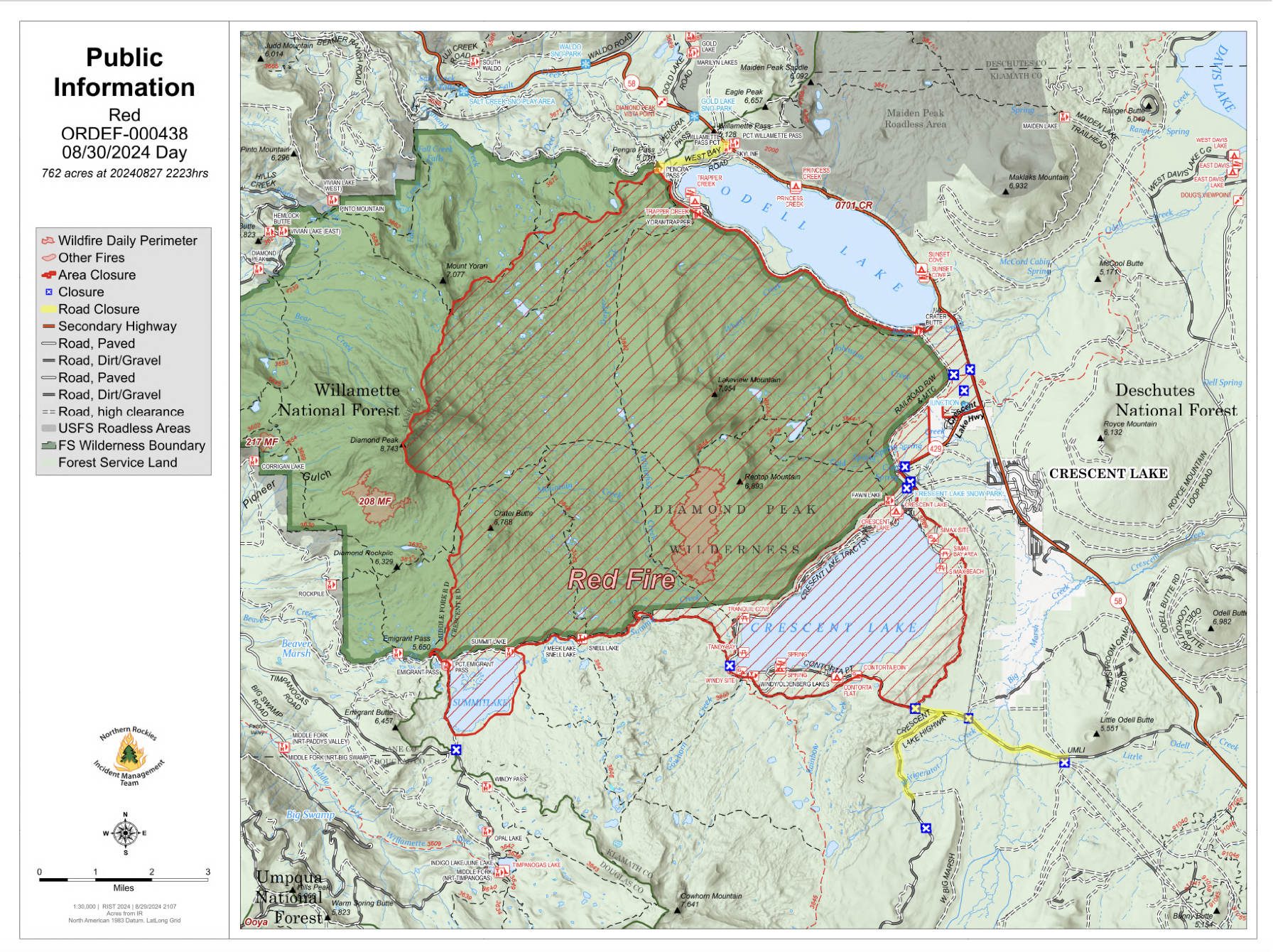
August 30 2024 Red Fire Daily Update 08 30 2024
Related Incident: Red Fire
Publication Type: News
Size: 762 acres Location: 5 miles west of Crescent Lake Junction, OR County: Klamath
Start Date: July 17, 2024 Cause: Lightning Containment: 0% Total Personnel: 144
Activities – The section of shaded fuel break between Crescent Lake and Summit Lake is progressing well and is anticipated to be complete by September 7. The bulk of the work remaining along the final portion of shaded fuel break is slash removal being accomplished by local contractors with equipment. Structure protection equipment remains in place along Crescent Lake. A 1.5-mile hose lay remains in place along the Whitefish Creek Trail on the southern edge of the fire to check fire spread along the trail.
Weather, Fire Behavior, and Smoke – Warmer and drier conditions persist across the fire area Friday under mostly clear skies. Continued warming and drying is expected though Sunday followed by a slight cool down until Wednesday, September 4 before another warming and drying trend sets in late next week. Isolated thunderstorms may impact the fire area Sunday into Monday. Fire behavior has increased due to warmer temperatures and low relative humidity. Smoke production has increased daily and is expected to increase today through the weekend. Depending on weather conditions, fire activity often lasts through September into early October.
Incident Strategy – A full suppression strategy is being implemented utilizing indirect tactics, shaded fuel breaks, structure protection equipment, trail, and hose lay. Firefighter and public safety remain the incident management team’s highest priority in managing this fire. Expect to see increased fire activity due to the warmer and dryer conditions.
Closures – To provide for the safety of firefighters, equipment operators, and the public the Deschutes National Forest emergency closure around Crescent Lake and in the Diamond Peak Wilderness is still in effect, including these areas: Forest Service Road 60 is closed, and road guards have been posted for public safety. More closure information is available at: https://www.fsa.gov/alerts/deschutes/alerts-notices/?aid=89091
Evacuations – The WILDFIRE! Level 1 – BE READY to Evacuate notice issued by Klamath County Emergency Management for Crescent Lake, Odell Lake, and Crescent Junction areas remains in effect (INCENDIO FORESTAL! Nivel 1 - ESTÉ PREPARADO para evacuar de las siguientes zonas: Crescent Lake, Odell Lake, Crescent Junction). Visit www.klamathcounty.org/300/emergency-management for more information or to sign up for alerts.
Fire Restrictions – Stage 2 Public Use Fire Restrictions – which prohibit open fires, including in developed campgrounds – remain in effect for the Deschutes National Forest. The Industrial Fire Precaution Level is currently Level III “Partial Shutdown.” Visit fs.usda.gov/detail/deschutes/home/?cid=stelprdb5297376 for more information.
Drone Restrictions – Aerial firefighting is suspended when unauthorized drones (UAS) are in the area. Unauthorized drone use over a fire area poses serious risks to fire personnel and the effectiveness of wildfire suppression operations. If you fly, we can’t.
McElwain Fire Update 08 30 2024
Related Incident:
Publication Type: Announcement
Location: 10 miles west of Helmville, Montana
Start Date: 8/23/2024
Cause: Lightning
Size: 116 acres
Containment: 25%
CURRENT STATUS
The McElwain Fire, located 10 miles west of Helmville in Powell County, is burning in grass and timber on private and Bureau of Land Management land under Montana DNRC wildland fire protection. The fire was mapped via an infrared flight overnight and has been downsized to 116 acres. The flight also identified hot spots close to the line that firefighters will focus on today as they continue to secure all control line 100-150 feet deep. The fire is 25% contained.
The fire is comprised of two adjacent fires, a north fire, and a south fire. Fire behavior includes creeping and smoldering with isolated torching. Resources are being downsized to match the current fire demands and now include four engines, one eight-person hand crew (Module), one water tender, and two skidgines. A Type 2 DNRC helicopter is available for support if needed. With the downsizing of resources and reduced complexity, the fire will transition to a Type 4 incident this evening.
Future fire updates will be provided only on Inciweb unless conditions warrant otherwise.
WEATHER & FIRE BEHAVIOR
Hot and dry weather will occur through Labor Day weekend, with light variable winds. Above normal temperatures and minimum relative humidities in the teens and lower 20s are predicted through the weekend, heightening the concern for increased fire behavior. The next chance for precipitation will be late Monday and Tuesday.
EVACUATIONS AND CLOSURES
The Powell County Sheriff’s Office has lifted all evacuation warnings in the area. Please visit the Powell County Sheriff’s Office Facebook page for specific information and updates. The public is asked to use caution if travel is necessary in the area due to increased firefighting traffic.
Powell County is currently in Stage 1 fire restrictions, which does limit campfires. Residents and visitors are asked to be extra careful when outdoors to limit human caused sparks. We cannot control the lightning, but we can prevent unintended human caused wildfires. Visit www.MTFireInfo.org for specific fire restriction information and fire prevention tips.
Actualizacin del incendio Whisky Creek Sandstone y Blister Creek 08 30 2024
Related Incident: Whisky Creek FireSandstone Fire
Publication Type: News
Tamañode Whisky Creek: 2,085 acres | Fecha de inicio: 20 de julio | Causa: De orígen humano | Contención 24%
Tamaño de Sandstone: 702 acres | Fecha de inicio: 5 de agosto | Causa: Rayo | Contención 75%
Total de recursos: 413 | Equipos de obreros: 7 | Camiones de bomberos: 9 | Topadoras: 1 | Otras maquinarias pesadas: 13 | Helicópteros: 4
Sigue el trabajo de extinción en el incendio Whisky Creek, a 6 millas al sureste de Cascade Locks, Oregón, y en los incendios de Sandstone y Blister Creek, a 9 millas al suroeste de Ripplebrook, Oregón. Estos arden en un terreno escarpado y accidentado en el Bosque Nacional Mt. Hood, donde los escombros rodantes y los árboles debilitados por el fuego dificultan el trabajo de extinción. La seguridad de los bomberos y la del público siguen siendo la principal prioridad. Este fin de semana del Día del Trabajo, por favor ayude a prevenir incendios forestales y proteja a los bomberos al recrear de manera responsable, respetando los cierres de incendios y cumpliendo con todas las restricciones vigentes contra incendios.
A las 6:00 esta mañana el Equipo 12 del Noroeste tomó el mando de los incendios. Ayer, los miembros del equipo de bomberos trabajaron en estrecha colaboración con sus colegas del equipo que se fué para garantizar que la transición de los incendios Whisky Creek, Sandstone y Blister Creek se realizara sin problemas. Los equipos 10 y 12 de NW agradecen a las comunidades locales por su apoyo y a las agencias asociadas por la asistencia que brindaron durante esta transición.
Whisky Creek: Ayer, las cuadrillas mejoraron la línea de mano en la cresta de Tomlike Mountain desde el sendero Herman Creek hacia el norte y hasta el borde del incendio. Los vuelos de reconocimiento aéreo detectaron una mínima intensidad de fuego, ya que la mayor parte del calor se ubicaba en el área de Herman Creek. Se pudo ver un poco de humo desde el interior del perímetro del incendio. Los bomberos comenzaron a remover equipos innecesarios, tales como mangueras y rociadores, de las áreas ya controladas del incendio. Tras haberse usado por varias semanas con maquinaria pesada y actividades de extinción, se reparó la superficie en mala condición de la carretera de servicio forestal (FSR) 2820-630. Hoy, las cuadrillas seguirán transportando equipos innecesarios cerca de Black Lake y patrullando la línea de contención este hasta Green Point Mountain. Sigue en curso el trabajo de reparación de las carreteras en FSR 2820.
Sandstone y Blister Creek: Ayer, un helicóptero vertió agua de manera específica sobre los focos de calor que quedaban en el extremo sur del incendio Blister Creek. Los operadores de maquinarias pesadas continuaron triturando, y convirtiendo la vegetación y los escombros en materiales más finos y controlables a lo largo de FSR 7010 y los caminos que salían de este. Los bomberos también continuaron nivelando la FSR 7010 para reparar los daños causados por las maquinarias pesadas de extinción. El día de hoy continúa el trabajo de trituración, clasificación, y monitoreo. Los bomberos continuarán observando y patrullando el perímetro del incendio en los incendios Sandstone y Blister Creek.
Clima y humo: Se han establecido condiciones calientes y secas sobre la zona y continuarán durante los próximos días. Este fin de semana resultará en algunas de las temperaturas más altas sobre el incidente, con máximas entre los 80 y los 90 grados. Se prevé que las condiciones de calidad del aire serán buenas para ambas áreas de incendios. Para ver más información sobre las condiciones del humo en su área, consulte: www.AirNow.gov
Cierres: Información sobre el cierre del Bosque Nacional Mt. Hood y el Área Escénica Nacional del Río Columbia se puede encontrar en escaneando el código QR o siguiendo el enlace en la esquina inferior derecha de la página. Los cierres se implementarn para la seguridad del público y de los equipos de bomberos.
Seguridad: El público juega un papel importante en la prevención del próximo incendio forestal. Tenga cuidado con cualquier fuente de ignición. Para obtener consejos de prevención, visite, https://keeporegongreen.org. Hay restricciones contra incendios dentro del Bosque Nacional Mt. Hood. Se puede ver más información en https://www.fs.usda.gov/main/mthood/fire. Se ha establecido una restricción temporal de vuelo (TFR) en ambas áreas de incendio.
Whisky Creek and Sandstone Fires Daily Update 08 30 2024
Related Incident: Whisky Creek FireSandstone Fire
Publication Type: News
Northwest Team 12
Whisky Creek, Sandstone and Blister Fires
August 31, 2024
Attached is the daily update for the fire.
Fire Information: (541) 208-1743, 8 AM - 8 PM
For all your links to incident information: https://linktr.ee/whisky_creek.2024
Whisky Creek Size: 2,085 acres | Start Date: July 20 | Cause: Human | Containment: 24%
Sandstone Size: 702 acres | Start Date: August 5 | Cause: Lightning | Containment 75%
Total Resources: 413 | Hand Crews: 7 | Engines: 9 | Dozers: 1 | Other Heavy Equipment: 13 | Helicopters: 4
Fire suppression continues on the Whisky Creek Fire, six miles southeast of Cascade Locks, OR and the Sandstone and Blister Creek Fires, nine miles southwest of Ripplebrook, OR. The fires are burning in steep and rugged terrain on the Mt. Hood National Forest where rolling debris and fire-weakened trees challenge firefighting efforts. Firefighter and public safety remain the incident’s top priority. This Labor Day weekend please help prevent wildfires and protect firefighters by recreating responsibly, respecting fire closures, and complying with all fire restrictions.
Northwest Team 12 took command of the fires at 6 AM this morning. Yesterday fire team members worked closely with their counterparts from the outgoing team to ensure a smooth transition of the Whisky Creek, Sandstone, and Blister Creek Fires. NW Teams 10 and 12 would like to thank the local communities for their support and agency partners for their assistance during this transition.
Whisky Creek: Yesterday crews improved the Tomlike Mountain ridge handline from the Herman Creek Trail north to the fire’s edge. Aerial reconnaissance flights detected minimal fire activity, with most heat concentrated in the Herman Creek area. Some smoke was observed from within the fire perimeter. Firefighters began backhauling, or removing, unnecessary equipment such as hoses and sprinklers from secured fire areas. After weeks of use by heavy machinery and suppression activities, the degraded road surface on Forest Service Road (FSR) 2820-630 was repaired. Today crews will continue backhauling unneeded equipment near Black Lake and patrolling the eastern containment line up to Green Point Mountain. Road repair efforts on FSR 2820 are ongoing.
Sandstone and Blister Creek: Yesterday a helicopter conducted targeted bucket drops on pockets of heat remaining on the Blister Creek Fire’s southern edge. Heavy equipment operators continued mastication efforts, converting vegetation and debris into finer, more manageable materials along FSR 7010 and its spur roads. Firefighters also made progress on grading FSR 7010 to repair damage from heavy firefighting equipment. Today mastication, grading, and monitoring efforts are ongoing. Firefighters will continue to monitor and patrol the fire perimeter on both the Sandstone and Blister Creek Fires.
Weather and Smoke: Hot and dry conditions have settled over the area and will continue for the next several days. This weekend will bring some of the highest temperatures of the incident with highs in the upper 80s to low 90s. Air quality conditions are forecast to be good for both fire areas. For more information on smoke conditions in your area, go to: www.AirNow.gov
Closures: Mt. Hood National Forest, Columbia River Gorge National Scenic Area, and Hood River County closure information can be found at https://linktr.ee/whisky_creek.2024. Please respect area closure orders for your safety as well as the safety of our firefighters.
Safety: The public plays an important role in preventing the next wildfire; use caution with all potential ignition sources. For prevention tips visit: https://keeporegongreen.org. Fire restrictions are in place within the Mt. Hood National Forest. More information can be found at: https://www.fs.usda.gov/main/mthood/fire. The TFR remains in effect for both fires: https://bit.ly/3T59VWv