
Wapiti Fire Daily Update Sunday 09 01 2024
Related Incident:
Publication Type: News
Wapiti Fire Update
Sunday, September 1, 2024 – 9:00 a.m.
Rocky Mountain Complex Incident Management Team 1
Dan Dallas, Incident Commander
Information Phone: 208-593-7132 (public) 208-901-8973 (media) Hours: 8 a.m. to 8 p.m.
Email: 2024.wapiti@firenet.gov
InciWeb:https://inciweb.wildfire.gov/incident-information/idbof-wapiti-fire
Facebook:https://www.facebook.com/wapitifireinfo2024/
Information Linktree:https://linktr.ee/WapitiFireInfo2024
Interactive Map:https://tinyurl.com/WapitiFireInfoMap
Special Notes: State Highway 21 is closed from east of Lowman to Stanley (MP84 to MP130) due to wildfire activity. The closure is necessary for public safety and to provide safe conditions for firefighters working along the highway. Highway 75 remains open.
Current Situation: Firefighters saw increased fire activity yesterday in divisions MM, WW, and PP as the smoke lifted in these areas. The smoke should clear this afternoon, allowing the fire to become more active in all divisions. This will give air resources the opportunity to provide more support to firefighters on the ground. Currently, two fixed-wing air attacks and six helicopters are assigned to the fire, with air tankers and scoopers available as needed. Most fire movement will likely be to the north and east due to prevailing winds. The firefighters’ focus continues to be on the protection of structures and communities while remaining vigilant for the fire’s potential to become active if conditions change. Though containment remains at 0%, the fire’s perimeter is becoming more secure each day due to the firefighters’ hard work in constructing firelines and other control features. All activities are being coordinated on the ground with natural and cultural resource specialists to protect known values.
Division DD: Crews will continue extending the indirect line from the Stanley Ranger Station to Redfish Lake. The objective is to tie into the suppression work done for the Bench Lake Fire from earlier this year. Fire managers are assessing opportunities for indirect line placement south of Redfish Lake. This indirect line would check the fire’s progress in the event it moves out of Sawtooth Wilderness towards Highway 75 and values at risk. The fire in the Wilderness is slowly growing towards the south but is not currently threatening values.
Division HH: Crews will continue constructing indirect fireline around Goat Falls, Stanley and nearby communities and extending the fireline from Goat Falls to the Stanley Ranger Station. This indirect line will tie in with the indirect line being constructed in Division DD.
Division KK and Structure Group East: Firelines once again held firm as crews continued to secure the fire’s edge and watch for hot spots. Crews will again use strategic firing operations to remove unburned fuels between the fire and control lines in the Iron Creek area. Crews will remain in and around communities and other values at risk, mopping up, reducing hazards, and maintaining defensible space. Mop-up continues on the large spot east of Highway 21, ensuring it is secure and poses no threat to the community.
Division PP: Yesterday, crews working in the area where the fire crossed Highway 21 used firing operations to establish line from National Forest Road 290 into the old Trap Fire. Crews will deepen this line and secure the fire’s edge today to stop the fire’s progress. They are also continuing prep work to protect Bradley Boy Scout Camp and other surrounding structures in the event the fire crosses Highway 21 further to the northwest. Work continues along Highway 21 near and east of the division break to keep the fire to the south side of the highway.
Division MM: Crews have constructed line from Bull Trout Lake around the campground to Martin Lake, extending to the perimeter of the 1992 County Line Fire. Today, crews will work to add depth to this fireline and watch for spotting. The actions are designed to protect the campground and prevent the fire from moving further north. Additional crews have been working along Highway 21 to keep the fire south and east of the highway.
Division WW and Structure Group West: Crews continue patrolling within Hanging Valley and the Wapiti Creek area, along the 524 road, and the Grandjean area looking for hot spots and removing hazards. Crews will begin cutting indirect fireline between Warm Springs and Ten Axe. Fireline construction will also continue around the Sourdough Lodge area. Crews will assess opportunities to harden the lines around the subdivisions of Two Ravens, Ten Ax, and Seven Peaks. Crews successfully burned out around the Warm Springs airstrip, and today will continue securing the fire’s edge and preventing it from impacting Bonneville Campground and the airstrip.
Division VV: The Division DD/VV break has been moved westward, and the focus in Division VV today will be on assessing opportunities for fireline construction south of Highway 21 on the southwestern corner of the fire. Fire supervisors are looking for opportunities to check the fire’s slow westward movement on the south side of the highway.
Weather, Fuels, and Fire Behavior:
Elevated fire weather conditions are expected today. Very dry conditions persist with afternoon humidity dropping to 10–15%. Moderate to heavy smoke is expected in the morning underneath an inversion. Increased west to southwest winds are expected to result in better smoke ventilation and improved visibility. Expect increased fire activity beginning about 1:00 p.m. An approaching low pressure system will bring a chance for isolated showers starting late Sunday afternoon. A Fire Weather Watch is in effect on Monday due to scattered thunderstorm and gusty and erratic wind potential.
Evacuations:
For evacuation information on the Wapiti Fire, please see the Custer County Sheriff’s Facebook page at https://www.facebook.com/p/Custer-County-Sheriff-Idaho-61558947312289/ and the Boise County Sheriff’s Facebook page at https://www.facebook.com/boisecountysheriff/.
Red Cross has established a shelter at the Church of Jesus Christ of Latter Day Saints at 24695 US-93, Challis, ID.
To sign up for Custer County CodeRED emergency notifications, text CUSTER to 99411 or enroll online at https://public.coderedweb.com/CNE/BF28E45537FF .
To sign up for Boise County Alert Sense emergency notification enroll online at https://public.alertsense.com/SignUp/publicUser.aspx?regionid=1163
Closures and Fire Restrictions:
State Highway 21 is closed from MP84 to MP130 for public and firefighter safety.
A Wapiti Fire Area Closure / Forest Order: 0414-04-151 for portions of the Boise, Sawtooth, and Salmon-Challis National Forests can be found at this site: https://www.fs.usda.gov/alerts/sawtooth/alerts-notices.
Boise National Forest Stage 1 Fire Restrictions / Forest Order: 0402-00-63 can be found at this site: https://www.fs.usda.gov/alerts/boise/alerts-notices.
Sawtooth National Forest Stage 1 Fire Restrictions / Forest Order 0414-00-044 can be found at this site: https://www.fs.usda.gov/alerts/sawtooth/alerts-notices.
Fire restrictions on state and private lands may be found at this site: https://www.idl.idaho.gov/fire-management/fire-restrictions-finder/.
A Temporary Flight Restriction is in place over the Wapiti Fire. Wildfires are a no-fly zone for unauthorized aircraft, including drones. If you fly, we can’t. For more information, visit http://knowbeforeyoufly.org.
Wapiti Fire Statistics:
Size: over 97,753 acres
Containment: 0%
Total Personnel: 1442
Location: Grandjean, ID
Reported: July 24, 2024
Cause: lightning
For More Information:
Information Phone: 208-593-7132
Email: 2024.wapiti@firenet.gov
InciWeb: https://inciweb.wildfire.gov/incident-information/idbof-wapiti-fire
Facebook: https://www.facebook.com/wapitifireinfo2024/
Linktree: https://linktr.ee/WapitiFireInfo2024
Interactive Map: https://tinyurl.com/WapitiFireInfoMap
Boise Fire Update September 1 2024 09 01 2024
Related Incident: 2024 Boise Fire
Publication Type: News
Headlines
- Traffic control remains in place along the Salmon River Road between Butler Flat and Nordheimer Flat for the safety of firefighters and residents. Expect up to 30-minute delays. Incident personnel driving vehicles with more than two axels will not be allowed on the road.
- Fire information phone: (707) 572-4860 or email at 2024.Boise@firenet.gov
- Get all your Boise Fire information in one mobile-friendly place! https://linktr.ee/2024boisefiresrf
- Evacuations are in place for residents near the fire area in Humboldt County. For the most current evacuation information please visit the Boise Fire linktree or visit--
- Humboldt County: https://humboldtgov.org/356/Office-of-Emergency-Services
- Siskiyou County: https://www.co.siskiyou.ca.us/emergencyservices
Leader’s Intent: The Boise Fire is being managed with a full suppression strategy.
Operational Update: Crews continue to make progress securing the active flanks along the eastern edge of the fire. Along the western flank, resources are conducting suppression repair and monitoring for any potential threats to the line. Snagging operations are in full swing improving safe passage on interior roadways for crews making access. Firefighter safety is top priority with the continued work being completed in steep terrain. Air assets are being utilized for water dropping and cargo missions as needed. Resource and cultural advisors continue to direct and coordinate suppression repair efforts around the area of China Creek which includes, creating water bars and repairing hand and dozer lines.
Weather and Fire Behavior: Sunday will provide a slight change in weather patterns with a 5-10 degree decrease along with an RH 40-45%. SSE winds will be prominent in the AM hours at a rate of 15-20 mph with gusts up to 25. On shore flow will prevail in the afternoon, providing 15-20 mph winds from the SSW. Crews are making progress and are attending to the active areas on the eastern flank. No significant fire spread is expected.
Ratio Mountain Fire Update 09 01 2024
Related Incident: Ratio Mountain
Publication Type: News
Incident Commander: Matt Racicot, Noah Criner (T)
Location: 15 miles north/northwest of Whitehall, MT
Start Date: 8/18/2024
Cause: Lightning
Size: 1,058 acres
Resources on Site: 4 crews; 1 engine
Total Personnel: 74
An overnight infrared mapping flight puts the fire at 1,058 acres. The northern, eastern, and southern edges of the fire are currently where fire managers want them, preventing forward progression of the fire toward critical values at risk. Recent strategic firing operations have been successful at protecting these values identified by local Jefferson County officials and cooperating agency representatives, by keeping the fire on Forest Service land west of the Hay Canyon Road and north of Little Whitetail Creek.
The fire, located between Ratio Mountain and Whitetail Reservoir, is burning in an area that has recently experienced several large fires. Fire footprints (or previously burned areas) lie to the north (State Creek Fire of 2020), the south (McClusky Fire of 2019), and the west (Placer Fire of 2021) of the fire location.
The entire area, including the previous fire footprints and the area immediately surrounding the Ratio Mountain fire, contains a large concentration of standing dead trees (“snags”) that pose challenges to ensuring firefighter safety and in responding to potential medical emergencies, jeopardizing the well-being of all responders.
CURRENT STATUS/PLANNED ACTIONS:
Utilizing Unmanned Aircraft System (“drone”) due to the steep, rocky slopes and numerous snags in the fire area, crews successfully implemented strategic firing operations to connect the eastern section of line to the fire footprint from the State Creek Fire of 2020. Crews completed similar strategic firing operations on the eastern side of the fire last week, igniting and burning the fuels along the Hay Canyon Road, working southerly along Pony Creek.
These firing operations have created some depth (reducing fuels available to burn) along the constructed lines. Crews will continue to “mop-up” and extinguish pockets of residual heat, securing and holding the edge in place.
Additional firing operations may be planned in the next few days, working from the southern section of line on the southeast corner of the fire and moving to the west, as needed. More smoke may be visible across the area in the coming days, if and when firing operations are conducted.
The UAS will be utilized to monitor the more remote portions of the fire via aerial reconnaissance, in anticipation of gusty winds predicted for Monday.
WEATHER AND FIRE BEHAVIOR:
The fire area will experience a warming and drying trend, with temperatures 10-15 degrees above normal in the lower 80s through the weekend. Winds today will be calm early, becoming east-southeast around 6 mph. Strong thermal belts could result in poor overnight relative humidity recoveries. A disturbance is expected to enter the fire area Monday into Tuesday, causing scattered showers and thunderstorms. Gusty, erratic winds, resulting in critical fire weather conditions, are possible.
Fire behavior consists of isolated torching, backing, and creeping. Fire progression to the northeast and east has been mitigated with the successful strategic firing operations; fire movement uphill to the northwest is possible, given the warmer and drier conditions through today.
CLOSURES AND RESTRICTIONS:
The Forest has issued an area closure around the fire area, north of Whitehall on the Butte Ranger District. An area closure often involves specific trail and road sections. The area closure information and maps can be found on the Forest website, under the Closures and Alerts tab. https://www.fs.usda.gov/alerts/bdnf/alerts-notices
This closure applies to the following National Forest System (NFS) lands, approximately 15 miles north of Whitehall.
All National Forest System lands within:
• T3N, R5W, SECTIONS 1, 2, 3
• T4N, R5W SECTION 35
Closures surrounding a fire area are necessary to protect the safety and welfare of the public and provide for safe firefighting efforts and access.
The Forest is in Stage 1 Fire Restrictions. Campfires are allowed only in a permanent metal fire grate/ring provided by the Forest Service in a designated, developed recreation site. Smoking is restricted to vehicles, in buildings, or in an area clear of flammable materials. Devices with an on/off switch that use LPG fuels are allowed in an area clear of flammable materials within 3 feet of the device.
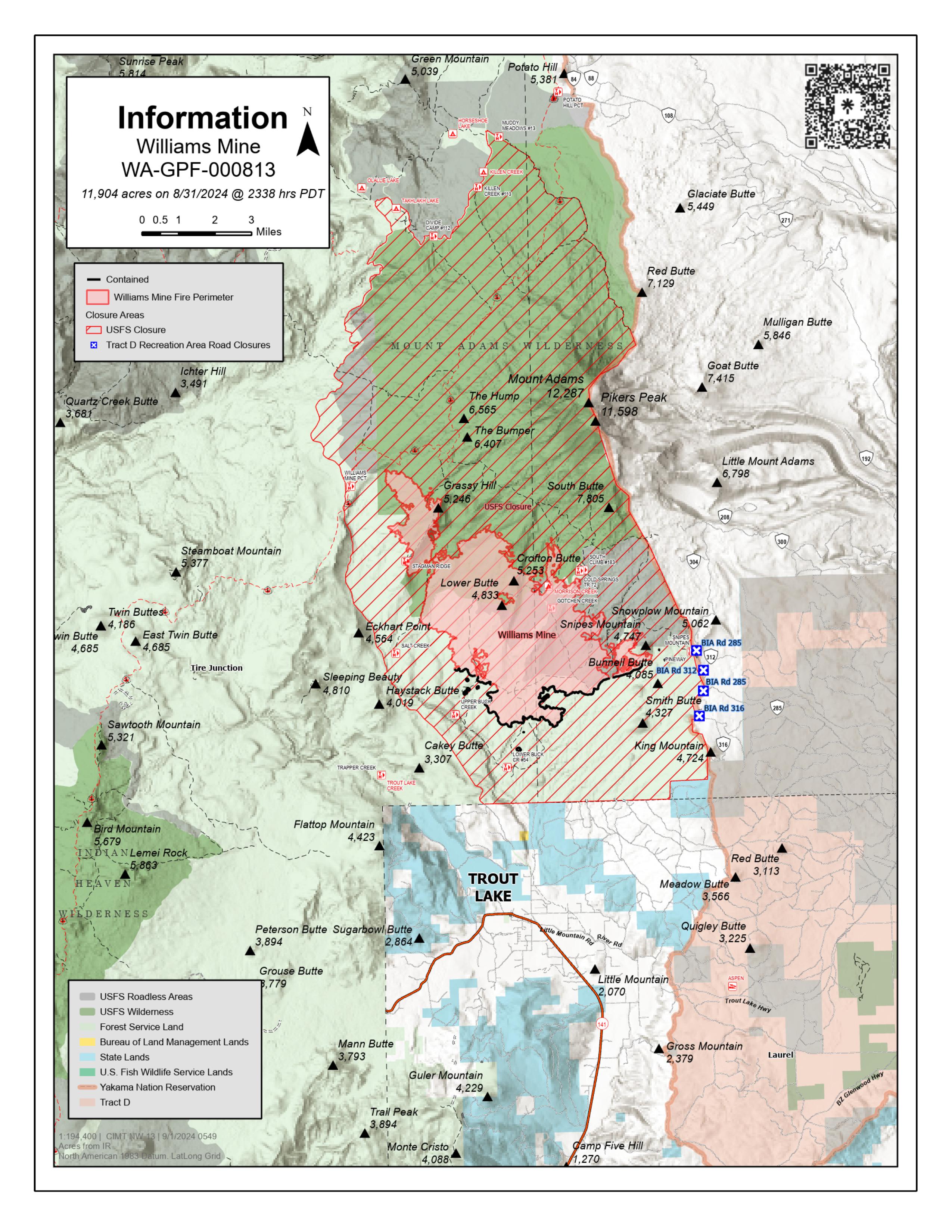
Williams Mine Fire Update 09 01 2024
Related Incident: Williams Mine Fire-GPNF
Publication Type: News
Williams Mine Fire Update for Sunday, September 1, 2024
The Williams Mine Fire put up another plume of smoke yesterday as the fire continued to spread north up the ridge near Morrison Creek. The growth has been in a fire scar, mostly burning down logs from the previous fire as a low-intensity ground fire. This area is in the Mt. Adams Wilderness and is not threatening the community of Trout Lake or private lands. Fire managers continue to monitor the fire by air and from the ground, and will take action to slow the fire’s spread if appropriate. Helicopters are available for water drops.
In response to the increased fire activity near Morrison Creek, fire personnel will start clearing fuels along the South Climb Trail to prepare it for use as a control line, if needed. Some of the work will consist of removing chunks of down logs, brush, and low limbs from trees to provide a break in the fuels.
Much of the Williams Mine Fire is burning in fire scars from the 2008 Cold Springs Fire, the 2012 Cascade Creek Fire, and the 2015 Cougar Creek Fire. In areas where these previous fires burned intensely, most of the mature trees were killed. This left a landscape with many large areas of standing dead trees (called snags), plus fallen dead trees. These intensely burned areas can be seen from a distance as the grayish areas on the lower slopes of Mt. Adams.
Brush, grass, and some young trees have grown since the previous fires. This has created large, fairly continuous areas with plenty of fuel, ready to burn again. On August 5, 2024, lightning provided the spark, and the Williams Mine Fire began. In many areas, it is consuming these dense fuels on the ground, cleaning up the site and reducing future fire danger.
SAFETY AND CLOSURES:
Some people continue to enter the closed areas on the Gifford Pinchot National Forest, endangering themselves and fire personnel working on the fire. Security guards are now staffing the roadblocks 24 hours a day. Violators who enter the closure are subject to fines up to $5,000 and up to six months imprisonment.
The Confederated Tribes and Bands of the Yakama Nation, Tract D Recreation Area is currently closed, please see Yakama Tract D Road Closure for more information. FS Rd 23 south of FS Rd 90 is still CLOSED to the public due to fire suppression activity. The revised closure for the Mt. Adams Wilderness and FS Rd 23 closure can be found at Williams Mine Fire: Area and Road Closure. The Pacific Crest Trail (PCT) is closed from the PCT's intersection with FS Rd 23 to Potato Hill. The current area closure spans the entire Mt. Adams Wilderness.
West Mountain Fires Daily Update 09 01 2024
Related Incident: Boulder FireDollar Fire
Publication Type: News
September 1, 2024
Fire Information Phone Line: 208-462-0345 (8 a.m. - 8 p.m.)
Email: 2024.Boulder.id@firenet.gov
QUICK FACTS
Fire Location Size Containment Assigned Personnel Inciweb link
Boulder 9 miles SW of Cascade 2,393 acres 57% 343 https://tinyurl.com/ycdfv3tv
Snag 11 miles E of Cascade 30,046 acres 3% 516 https://tinyurl.com/4k9dk3mu
Dollar 18 miles NE of Cascade 3,419 acres 0% 79 https://tinyurl.com/bef6r3tz
Goat 11 miles SE of Cascade 2,848 acres 0% 83 https://tinyurl.com/2h4a3dvr
Cause: Lightning (All Fires) Total Incident Personnel: 1,061
- Helicopters were unable to fly today due to the heavy smoke hindering visibility, however an Unmanned Aircraft System (drone) was able to safely assist with firing operations burnout operations.
- Six of the 14th Brigade Engineer Battalion based at Joint Base Lewis McChord assisted with mop up and firing efforts on the Snag Fire, while the remaining two crews assisted with line construction on the Dollar Fire.
Weather | Anticipated Fire Behavior:
- Smoky conditions linger this morning under a persistently stable air mass and sunny skies. As the day progresses, southwest winds gusting to 20 mph will arrive, helping to clear smoke from the area by early afternoon. Minimum relative humidity is expected to be in the single digits. With low humidity, increased winds, and sun exposure, increased fire activity is predicted with potential for spot fires carrying up to 0.4 mile. Cloud cover increases in the evening, which may trigger isolated storms overnight tonight, and a possibility of dry lightning.
Boulder Fire:
- Crews began a small firing operation on the northwest section of the fire where increased fire activity has been observed over the past two days. Additional firing may be needed along the Blue Lake Trail.
- Firefighters continue to secure containment lines, chip brush, branches, and other unburned fuels, and mop up while they monitor for potential issues.
Dollar Fire:
- Firefighters continue to work the Dollar Fire, seeking opportunities to establish containment by line construction and/or use of firing operations. They are considering the need for firing out green fuels near the southeast corner of the fire.
- Fire crews will also continue to monitor and mop up areas where work has already occurred.
Snag Fire:
- Masticators were used to chip brush adjacent to the Warm Lake area, reducing available fuels between the active fire edge and values at risk. Engines were also working in the area. They will continue to be in the area today.
- Hot shot crews were mopping up the western edge of the fire that crossed Warm Lake Road and scouting terrain suitable for line construction to contain the fire north of the road.
- The firing operation that was implemented along the southern edge of the fire is steadily backing down the hill to Forest Road 409.
- Personnel will be checking the stability of bridges in the burn area and protecting them from fire so they can safely open roads when the time is appropriate.
Goat Fire:
- Little movement was observed on this fire over the last couple of days.
- Crews continue making improvements to Forest Service Trail 099 so the trail may be used as a contingency holding feature in the case of fire moving in that direction.
Fish Creek Fire Update Sunday 09 01 2024
Related Incident:
Publication Type: News
Northern Rockies Team 1, Incident Commander Brent Olson
Location: 7 miles SW of Togwotee Pass
Start Date: Friday, August 16, 2024
Cause: Lightning
Size: 12,978 acres
Percent complete: 44%
Resources: 490 Total Personnel: 8 Hand Crews; 20 Engines; 1 Dozer; 12 Heavy Equipment; 5 Helicopters
KEY MESSAGES:
Completion has now increased to 44 percent on the fire. Percent complete refers to the degree to which the confine/point protection strategic actions have been accomplished. Confine is a wildfire response strategy of restricting a wildfire to a defined area, primarily using natural barriers that are expected to restrict the spread of the wildfire under the prevailing and forecasted weather. Point protection tactics include the installation of pumps, sprinkler systems, vegetative fuels reduction, and other actions to protect values-at-risk.
On wildfire assignments Incident Management Teams are typically tasked with the initial attack on new wildfires within a designated area around the fire and to provide support to other wildfires as requested. Yesterday, two heavy helicopters and one hotshot crew was loaned to the Jackson Ranger District to suppress a new fire start near Jackson. While the fire wasn’t within the Fish Creek Fire’s designated response area, it demonstrates the high priority placed on suppressing new fire starts and keeping those fires small.
CURRENT STATUS:
Yesterday, conditions were favorable for aerial firing operations on the east side of the fire area to remove a pocket of unburned fuel and prevent the fire from spotting across the 2007 Hardscrabble fire scar. The indirect control line located from Highway 26 south to Pilot Knob and the Moccasin Basin Trailhead was utilized as planned as a holding feature during firing operations. On the northeast side some unburnt islands have burned together aided by hand firing operations as needed. Crews and equipment continued to work on widening and improving the shaded fuels break along Deception Road south of the Brooks Lake Lodge. On the fire’s northwest side south of Hwy 26 and alongside of Flagstaff Road, firefighters utilized heavy equipment to continue construction of a shaded fuel break to assist with point protection of Togwotee Lodge. Structure protection crews reviewed plans and tested equipment in the Brooks, Pinnacle and Breccia areas. Due to the colder temperatures at night, the structure protection pumps, hose, and equipment need to be checked and tested every morning to ensure functionality when needed. Structure Protection resources also started assessing protection needs farther east of the fire along the Highway 26 corridor.
Today, the work to construct and improve indirect control lines will continue along the Deception and Flagstaff Roads as part of the confine/point protection strategy employed to protect the identified values at risk. Crews will patrol and monitor the areas where firing operations were completed. Structure protection crews will test hose lays to make sure they are ready when needed and continue assessments of the values at risk in additional areas along the Highway 26 corridor.
WEATHER AND FIRE BEHAVIOR:
It will be warm and dry again today with a return to a more south to southwesterly wind this afternoon. Humidity will again drop to around or below 15 percent. The smoke mixing height will be high today which means that there will be less smoke impacts at ground level.
Persistent fire behavior will continue into today. There will be a change back to southerly winds after the gusty east winds experienced overnight. There will be isolated fire activity in timbered areas with heavy fuels. Fuel conditions and weather exist today to promote fire behavior with low to moderate rates of spread, torching and downwind spotting up to three tenths of a mile. Significant growth is only anticipated in areas where there is alignment of wind, slope and continuous burnable fuels. Fire behavior will increase after the inversion lifts around 10:00 a.m., peaking around 6:00 p.m. and then moderating after dark.
AIR QUALITY AND SMOKE:
Air quality and smoke conditions and forecasts can be found at https://www.airnow.gov/.
CLOSURES AND EVACUATIONS:
A joint Closure Order for the fire area has been issued by the Bridger-Teton and Shoshone National Forests for public and firefighter safety. Please do not enter the closure area or use the Forest Roads that are closed.
The Fish Creek Area, Roads, and Trails Closure Order (map) has been established for public and firefighter safety in the fire area. Full details can also be found at https://www.fs.usda.gov/alerts/btnf/alerts-notices.
Fremont County: Brooks Lake, Pinnacle Drive and Breccia Drive area remain in the Level 2 Evacuation notice. A Level 2 Evacuation means “Be Set” to evacuate. You must prepare to leave at a moment’s notice. This level indicates there is significant danger to your area, and residents should either voluntarily relocate to a shelter or with family/friends outside of the affected area, or if choosing to remain, to be ready to evacuate at a moment's notice. See the alert notice on the Fremont County Fire Protection District Facebook page.
Teton County: The Teton County Division of Emergency Management utilizes a Ready, Set, Go www.tetoncountywy.gov/1846/Ready-Set-GO system for evacuation messaging. All residents should be in the Ready status by preparing for evacuations and becoming fire adapted.
US HWY 26/287 continues to experience smoke and sometimes limited visibility. Wyoming Department of Transportation (WYDOT) is working closely with Fremont County Emergency Management and fire officials for the safety of motorists and firefighters. Drivers are encouraged to visit https://www.wyoroad.info/ prior to traveling on US HWY 26/287 for road status and information, or download the Wyoming 511 app at https://www.wyoroad.info/511/WY511Mobile.html to monitor for any changes due to fire activity.
A Temporary Flight Restriction (TFR) has been established over the fire area. This allows for firefighting aircraft to safely work over the fire area. Federal, state, and local wildland fire management agencies and the Federal Aviation Administration (FAA) urge members of the public not to fly “Unmanned Aircraft Systems (UAS)” or drones over the Fish Creek Fire. Unauthorized drone flights pose serious risks to firefighter and public safety and the effectiveness of wildfire suppression operations. If you fly, WE CAN’T!
Sharrott Creek Fire Daily Update 09 01 2024
Related Incident:
Publication Type: News
Northern Rockies Team 3, Incident Commander Mike Behrens
Location: Three miles west of Stevensville, Montana in Ravalli County
Start Date: 8/23/2024
Cause: Lightning
Size: 1,775 Acres
Completion/Containment: 0 percent
Resources assigned: 586 people
Current Status
On the northern boundary of the fire, firefighters cooled hot spots, held and improved established hand and dozer line, working to the east. These activities will continue today. Contingency plans are in place for the neighborhoods nearest the northeastern edge in the event spotting occurs from firing operations on the east perimeter. Portions of the northwestern side of the fire continue to hold heat.
Burnout operations were completed on the east side Saturday, bringing the fire edge down to the dozer line. Crews will clean up and mop up the edges of the burnout along the east perimeter today.
Several spots formed to the southwest during firing on the south edge, near the St. Mary’s Peak trailhead and in the Silverthorn drainage. Multiple Hotshot crews will work to address those spots. Additional firing operations will occur today if necessary to address the spots or secure the control line. Further south, firefighters will improve contingency lines along the Forest Service boundary.
Structure protection resources will patrol the neighborhoods during the day. Night shift resources will work on the southern and eastern edge and patrol affected neighborhoods. They also have initial attack responsibilities. Air operations were limited by the lingering smoke, which hindered visibility for pilots most of the day yesterday. Helicopters will support firefighters today as conditions allow.
Weather and Fire Behavior
Temperatures will be in the lower 80s, with relative humidity in the mid-teens. Winds will remain light and upslope. Smoke is suppressing active fire behavior until the dispersion of the inversion. Flanking, backing and isolated small group torching can be expected, especially as fire reaches patches of subalpine fir in Silverthorn drainage. Further spotting is expected in stringers of subalpine fir.
SMOKE
For the current smoke reports, visit https://www.airnow.gov/
EVACUATIONS, RESTRICTIONS, CLOSURES
The Ravalli County Sheriff’s Office has issued evacuation orders and warnings for neighborhoods in the vicinity of the Sharrott Creek Fire. Download the Ravalli Co. Sheriff’s Office app for information. Evacuation questions can be directed to the Ravalli County Emergency Operations Center at 406-375-6650. The Bitterroot National Forest has issued an area closure from North Fork Sweeney Creek to Sweathouse Creek. See https://tinyurl.com/Sharrottclosure for the order and map. There are temporary flight restrictions (TFR) over the fire area west of Highway 93 from Bass Creek to Big Creek.
Railroad Fire Update Sept 1 2024 09 01 2024
Related Incident:
Publication Type: News
Location: Railroad Creek/ Skalkaho Creek confluence, 26 miles SE of Hamilton
Start Date: 7/25/2024
Cause: Lightning
Size: 246 acres (Daly Fire = 100 acres)
Completion/Containment: 0%
12 Total Personnel
CURRENT STATUS
The Railroad fire is currently assessed at 160 acres. Because of the steep and difficult terrain and high risk to responders, due to suppression difficulty and abundant snag hazards, suppression actions have been limited. However, crews did perform burnout operation on Friday and Saturday between the Bowles Creek fire scar and the 711 road to limit fire growth to the north, and to moderate severity in the railroad Creek drainage. Total acres burned were 40-60 acres with an additional 20-30 acres of ignition planned the coming days. After these operations the fire will have much less potential to spread north towards the Snotel site. Smoke will be visible at approximately 10:00 the morning from elevated points in the Skalkaho creek area and into the valley.
CLOSURES
Currently, there are road closures in effect.
HWY 38 (Skalkaho Hwy remains OPEN)
See InciWeb for map and details on area closure: https://inciweb.wildfire.gov/incident-closures/mtbrf-railroaddaly-fire
Limepoint Fire Daily Update September 1 2024 09 01 2024
Related Incident: Limepoint Fire
Publication Type: News
Limepoint Fire
Sunday, September 1, 2024
Contacts for Fire Information:
208-992-3032 or 2024.limepoint@firenet.gov
https://inciweb.wildfire.gov/incident-information/idpaf-limepoint-fire
https://www.facebook.com/payettenationalforest/
The Limepoint Fire added over 200 acres due to a combination of infrared mapping and interior fires consuming fuel. None of the fires currently threaten containment lines and containment is holding at 93%. The smoke that was visible yesterday evening was from those interior fires. Smoke from interior burns will likely be visible again today, and an air quality alert has been issued until 3:00 p.m. this afternoon.
Salvaged timber operations are complete and all salvaged wood has been decked. The log decks are clearly marked and have been slated for a salvage timber sale. The wood is not available to the public.
Sunday will be hot and dry, with clear skies apart from the smoke. Sunday night an upper level low moves into the area, bringing with it a small chance for showers and thunderstorms Monday morning. Additional storms are possible late Monday afternoon, with gust potential to 50 mph. A fire weather watch in in effect for Monday.
As hunters and recreators continue to make their way to their favorite playground on the Payette National Forest, we ask that the public please prioritize driving safety. As there are still road closures in effect, motorists should expect increased congestion on open roads. Know that heavy equipment and fire crews are still working in the fire area. Dust, poor visibility, and rough roads can all make driving difficult. Please slow down, use your lights and seatbelts, and do not tailgate.
Evacuations: Cuprum remains at a Level 1 (READY) evacuation level.
Closures: The Forest Closure Order updated Monday, August 26, 2024, at 7:00 a.m. Some areas previously closed to the public have been reopened. For details about the closure, visit https://www.fs.usda.gov/alerts/payette/alerts-notices. There is still a lot of work being done in the fire area; for your safety and the safety of firefighters, please observe the existing Payette Forest Closures still in effect and watch out for firefighters and fire traffic.
Restrictions: Effective 12:01 a.m. on Friday, August 30, 2024, Stage 1 fire restrictions were lifted. There are currently no fire restrictions in place, but visitors are reminded that vegetation is still dry and to be careful with all use of fire outdoors.
House Draw Fire Daily Update for September 1 2024 09 01 2024
Related Incident: House Draw Fire
Publication Type: News
Repair efforts are on-going; Red Flag Warning in effect for Flat Rock, Constitution and House Draw Fires
Daily Update September 1, 2024
Fire Information Phone: 307-201-3885 (8 a.m. – 8 p.m.)
Media Information Phone: 307-543-7202 (8 a.m. – 8 p.m.)
Suppression Repair Phone: 307-303-7642 (8 a.m. – 8 p.m.) This phone line is for private landowners to contact fire officials with repair of heavy equipment line or cut fence that occurred during suppression efforts.
Email: 2024.housedraw@firenet.gov
Acres: Flat Rock – 52,421; Remington – 196,368; Constitution – 24,594; House Draw – 174,547
Acreage changes may occur due to overnight operations and infrared mapping.
Containment: Flat Rock – 78% Remington – 81%; Constitution – 95%; House Draw – 94%
Location: Flat Rock – 11 miles northwest of Gillette, WY; Remington – 14 miles northeast of Leiter WY, multiple counties in southeast MT; Constitution – 11 miles northeast of Gillette, WY; House Draw – 9 miles southeast of Buffalo, WY
Start Date: August 21, 2024 Personnel: 433 Fuels: Grass, brush and timber
Resources: 6 crews | 30 engines | 4 water tenders | Heavy Equipment
Highlights: Suppression repair efforts continue across the Flat Rock, Remington, Constitution and House Draw fires. As crews carry on with repair activities, the fire update release schedule will be modified to occur every-other-day through the duration of Southwest Area Incident Management Team 5 management of the incident.
Fire Activity: Hot and dry conditions continue today, supporting smoldering and creeping fire activity in interior zones of the fires.
Flat Rock – Crews on the Flat Rock Fire observed isolated heat sources within the north flank yesterday, Saturday, August 31. Today, heavy equipment and crews continue repairing fireline on the north end while crews on the south end of the fire assess fence lines and scout additional repair needs.
Remington – Warm, dry weather continued yesterday on the Remington Fire, supporting smoldering fire activity in sheltered timbered stands, primarily along the northern portion. Also on the north end of the fire, heavy equipment operators repaired fireline while crews on the eastern side conducted repair work near Lee and Boyce Roads. Today, heavy equipment will continue line repair as hand crews scout additional repair needs in the southwest portion of the fire area.
Constitution – Heat sources remained along the east flank of the Constitution Fire yesterday. Air resources also responded to an isolated flare-up that did not pose any threats to containment lines. Hotshots will patrol and mopup the area today as suppression repair crews build on the success of yesterday’s work along the eastern perimeter.
House Draw – Minimal heat sources remain on the House Draw Fire. Today, heavy equipment will repair line along the eastern perimeter and northwest side of the interstate.
Evacuations: No evacuations are in effect on the Flat Rock, Remington, Constitution or House Draw fires.
Weather: A Red Flag Warning is in effect today, September 1, for the Flat Rock, Constitution and House Draw fires as temperatures climb into the mid-90s, winds increase and relative humidity drops into the teens.
Fire Restrictions and Closures: Fire Restrictions are in place across the fire area including:
- The Custer Gallatin National Forest (Powder River and Rosebud Counties, Montana) implemented road closures within the Remington Fire burned area located on National Forest System lands, effective August 30, 2024. More information available at https://www.fs.usda.gov/Internet/FSE_DOCUMENTS/fseprd1202405.pdf.
- Stage 1 Fire Restrictions for Custer Gallatin National Forest, Ashland Ranger District (effective August 1, 2024). More information available at https://www.fs.usda.gov/alerts/custergallatin/alerts-notices/?aid=89447.
- Stage 1 Fire Restrictions for Bureau of Land Management Buffalo Field Office in Johnson County (as of July 1, 2024) and Campbell and Sheridan Counties (as of July 9, 2024). More information available at https://www.blm.gov/programs/public-safety-and-fire/wyoming/fire.
- Stage 1 Fire Restrictions for Sheridan, Campbell and Johnson Counties in Wyoming (as of July 9, 2024). More information available at https://wsfd.wyo.gov/fire-management/fire-restrictions.
- Stage 1 Fire Restrictions for Thunder Basin National Grasslands within the Douglas Ranger District in Converse, Campbell, Crook, Natrona, Niobrara, Platte, and Weston counties in the State of Wyoming (as of August 7, 2024). More information available at https://www.fs.usda.gov/detail/mbr/news-events/?cid=FSEPRD1199001.
- The Medicine Bow-Routt National Forest implemented a temporary closure of the popular Weston Recreation Area on the Thunder Basin National Grasslands within the Constitution Fire (Johnson County, WY), effective August 23, 2024. More information available at https://www.fs.usda.gov/Internet/FSE_DOCUMENTS/fseprd1201513.pdf.
More Information:
InciWeb (House Draw Fire): https://inciweb.wildfire.gov/incident-information/wyhpd-house-draw-fire
InciWeb (Remington Fire): https://inciweb.wildfire.gov/incident-information/mtgnf-remington-fire
Public Information Linktree: https://linktr.ee/housedrawfire
Facebook: https://www.facebook.com/SWIMT5/