
Rail Ridge Fire Update September 6 2024 8 am 09 06 2024
Related Incident:
Publication Type: Announcement
Headlines
- California Complex Interagency Incident Management Team 10 took command of the fire at 7:00 a.m. this morning, September 6, 2024.
- Find current information (including automatically updating acreage) at https://linktr.ee/RailRidgeFire
Operational Update
Current control objectives on the lightning-started Rail Ridge Fire include keeping the fire southwest of Highway 26, east of the Wolf Mountain Communications Tower, north of County Road 308/Paulina Supplee Highway, and west of Laylock Creek, 49/63C Road. However, incident control objectives are anticipated to evolve as resources arrive and conditions change.
Priorities for today include providing point protection around structures on private property to the north and south of the fire area. Crews will work to build containment directly on the fires’ active edge as they are able, while simultaneously looking for opportunities to create indirect fire line where possible. Along with reinforcing primary lines, they will look for opportunities to build alternate and contingency lines in advance of the expected critical fire weather.
The fire was most active yesterday to the northeast, where it pushed towards the Aldrich Mountain Lookout. Protecting the lookout and its communication infrastructure is a priority for firefighters today. Firing operations on the east and southern side of the fire have held well, and crews will continue to hold those.
On the northwestern side of the fire, crews are looking for opportunities on road systems adjacent to the Black Canyon Wilderness areas to try to cut off spread to the north and west.
A significant resource order has been submitted and additional engines, crews, and heavy equipment will be plugged into the operation today as they arrive.
Weather
Critical fire weather is predicted into the next few days, with high temperatures and erratic winds expected. Smoke has hampered aerial firefighting efforts, but with clearing yesterday crews were able to start to fly, and aircraft is available for incident use when feasible.
Park Fire Update Friday 09 06 2024
Related Incident: Park Fire
Publication Type: News
Park Fire Update: Friday, September 6, 2024
Southwest Complex Incident Management Team 2 Incident Commander John Truett
Size: 429,603 acres
Start Date: July 24, 2024
Containment: 99 percent
Total Personnel: 595
Resources: 1 helicopter, 14 crews, 13 engines, 15 dozers, 31 water tenders, 6 masticators, 7
chippers, 22 excavators, 7 feller bunchers, 12 skidsteers, 3 log loaders, 1 processor, 1 backhoe, 5 road
graders
CURRENT SITUATION: Crews are making significant progress on repair work, particularly east and west
of the Highway 32 corridor where they expect projects to be largely completed by the end of this
weekend. Those crews and equipment will then relocate to areas generally west of Highway 89 and
south of Highway 36. The public information map (tinyurl.com/dhnzex3r) shows points and firelines
that need to be repaired, are being repaired, or are awaiting inspection before being considered
completed. View photos and videos of firefighters and equipment doing repair work on the Lassen
National Forest Facebook page: facebook.com/LassenNF.
WEATHER & FIRE SAFETY: Isolated, dry thunderstorms may occur on the east side of the fire this
afternoon. It will also be very hot, dry, and—unlike recent days—windy. Southwest winds could gust
up to 20 mph, increasing the likelihood that smoldering snags, stumps, and logs will produce more
visible, but still minimal, smoke. Smoke from other local and regional fires is affecting some
communities near the Park Fire. Get air-quality information for your area and view a smoke map
here: tinyurl.com/ypkfbkyn. Higher wind speeds could also increase the likelihood of fire-weakened
trees falling across roads and trails, so be aware of your surroundings and comply with the forest
closure order, which is to provide for both firefighter and public safety.
FOREST CLOSURE: Parts of Lassen National Forest lands, roads, and trails near the fire are
temporarily closed as fire-suppression repair activities continue. If you plan to recreate on your
public lands, be prepared and view Forest Order No. 06-24-07 and map here:
fs.usda.gov/alerts/lassen/alerts- notices. Know where you are in relation to the closure area;
unsigned or unstaffed forest roads does not necessarily mean they or the surrounding areas are
open.
FIRE RESTRICTIONS: Know before you go! Fire restrictions are in effect within the Lassen National
Forest. For details, view Forest Order No. 06-24-04 here: fs.usda.gov/alerts/lassen/alerts-
notices. Find links to other land management agencies’ fire restrictions in the Park Fire
Information Linktree (URL and QR code below).
Park Fire Information (Southwest CIMT 2): 530-414-9298 | 2024.park@firenet.gov
Park Fire Information (CAL FIRE): 530-529-9233
Park Fire Linktree (fire information website links): linktr.ee/park_fire
Ruby Fire Update for Friday September 6 2024 09 06 2024
Related Incident: Ruby Fire
Publication Type: News
Ruby Fire Quick Facts
Size: 970 acres Location: North Cascades National Park, Ruby Mountain, Diablo, Washington
Containment: 0% Cause: Lightning/Natural
Start Date: August 9, 2024 Total Personnel: 54
Fire Information: 360-208-8096
Inciweb: https://inciweb.wildfire.gov/incident-information/wancp-ruby-fire Email: 2024.Ruby@firenet.gov
Current Status: Yesterday’s unseasonably warm temperatures, low relative humidity and wind caused a significant increase in fire activity. Fire behavior included backing and single tree torching on both the northwestern flank and southeastern flank of the fire, near Panther Creek. In an effort to reduce the risk of fire spreading towards State Route 20 (SR20) and other key values at risk, a Type 2 helicopter equipped with a collapsible water bucket, referred to as a Bambi Bucket, effectively dropped water on hot spots located throughout the fire. For public and firefighter safety, we ask the public to not stop along the road to watch firefighting operations, to avoid walking onto the bridge along SR20 at Colonial Creek, and avoid entering the closure area at Colonial Creek South Campground.
Planned Actions: Fire managers continue to remain vigilant and implement tactics to confront critically dry and unstable weather conditions, including using aviation to conduct bucket drops to cool hot spots. Firefighters will keep working on protecting park campgrounds like Colonial Creek South, trails, backcountry camps, critical infrastructure and other resources in preparation for possible fire growth. The Ruby Fire is a full suppression fire, and firefighters are utilizing strategies and tactics that provide the highest likelihood for success, while mitigating risks to firefighters and the public. The main objectives are protecting human life, minimizing damage to values at risk and limiting wildfire spread to the north and west.
Weather: The National Weather Service has issued a RED FLAG WARNING UNTIL 11 PM PDT FRIDAY, and a HEAT ADVISORY UNTIL 11 PM PDT FRIDAY. Upper-ridging along with a surface thermal trough is contributing to warm and dry conditions across the incident area. Critical fire weather is expected into Friday with relative humidity values as low as 15 to 25% with an unstable airmass. Offshore flow will inhibit relative humidity recoveries tonight. Conditions are expected to improve however as onshore flow returns. Cooler and more moist air will arrive later this weekend but we won't be completely out of the woods on Saturday.
Closures: There are multiple closures in place for public safety; Colonial Creek South Campground and boat launch, Thunder Arm south of Diablo Lake, and area trails and camps. Closures: https://go.nps.gov/fireclosures
Smoke: Air quality is forecast to be GOOD on Friday and Saturday https://www.airnow.gov/
Burning Restrictions: Campfires, the ignition of wood, briquettes, or any fuel in fire pits, fire pans and barbeque grills, are banned in all portions of North Cascades National Park Service Complex: North Cascades National Park, Ross Lake National Recreation Area and Lake Chelan National Recreation Area.
Drone Restrictions: Drones can seriously impact the safety of firefighting efforts, and operating drones within North Cascades National Park is prohibited, except with prior written approval from the superintendent.
Cooperating Agencies & Tribes: National Park Service, Upper Skagit Indian Tribe, Seattle City Light, Whatcom County, Whatcom County Sheriff’s Office, Washington State Dept. of Transportation.
If you would like to sign up for our daily updates, please send an email to: 2024.Ruby@firenet.gov
Actualizacin Sobre Incendio Park Viernes 6 de Septiembre de 2024 09 06 2024
Related Incident: Park Fire
Publication Type: News
Actualización Sobre Incendio Park: Viernes, 6 de Septiembre de 2024
Administración De Incidentes Complejos Del Área Suroeste -
Equipo 2 John Truett - Comandante Del Incidente
Tamaño: 429,603 acres
Fecha de Inicio: 24 de Julio de 2024
Contencion: 99%
Personal Total: 595
Recursos: 1 helicóptero, 14 cuadrillas, 13 camiones de bomberos, 15 topadoras, 31 camiones de agua,
6 masticadoras, 7 astilladoras, 22 excavadoras, 7 máquinas para talar árboles, 12 minicargadoras, 3
apiladoras, 3 cargadores de troncos, 1 procesador, 1 retroexcavadora, 5 motoniveladoras
SITUACIÓN ACTUAL: Las cuadrillas están logrando avances significativos en los trabajos de
reparación, particularmente al este y al oeste del corredor de la autopista 32, donde esperan que
los proyectos estén en gran parte terminados para fines de este fin de semana. Luego, las
cuadrillas y equipos se reubicarán en áreas generalmente al oeste de la autopista 89 y al sur de la
autopista 36. El mapa de información pública (tinyurl.com/dhnzex3r) muestra puntos y líneas de
fuegos que necesitan ser reparados, están siendo reparados o están esperando inspección antes de
considerarse completados. Vea fotos y videos de bomberos y equipos realizando trabajos de
reparación en la página de Facebook del Bosque Nacional Lassen: facebook.com/LassenNF.
CLIMA Y SEGURIDAD CONTRA INCENDIOS: Esta tarde pueden ocurrir tormentas aisladas y secas en el lado
este del incendio. También será muy caluroso, seco y, a diferencia de los últimos días, ventoso.
Los vientos del suroeste podrían tener ráfagas de hasta 20 mph, lo que aumenta la probabilidad de
que troncos, tocones y troncos ardiendo produzcan humo más visible, pero aún mínimo. El humo de
otros incendios locales y regionales está afectando a algunas comunidades cercanas al incendio
Park. Obtenga información sobre la calidad del aire en su área y vea un mapa de humo aquí:
tinyurl.com/ypkfbkyn. Las velocidades más altas del viento también podrían aumentar la probabilidad
de que los árboles debilitados por el fuego caigan sobre caminos y senderos, así que esté atento a
su entorno y cumpla con la orden de cierre del bosque, que es para brindar seguridad tanto a los
bomberos como al público.
CIERRE DE BOSQUES: Partes de los terrenos, caminos y senderos del Bosque Nacional Lassen cerca del
incendio están cerrados temporalmente mientras continúan las actividades de reparación de extinción
de incendios. Si planea recrear en sus tierras públicas, prepárese y vea la Orden Forestal No.
06-24-07 y el mapa aquí: fs.usda.gov/alerts/lassen/alerts-notices. Sepa dónde se encuentra en
relación con el área de cierre; Los caminos forestales sin rótulos o sin personal no significa
necesariamente que estos o las áreas circundantes estén abiertos.
RESTRICCIONES DE INCENDIO: ¡Infórmate antes de ir! Hay restricciones contra incendios vigentes
dentro del Bosque Nacional Lassen. Para más detalles, consulte la Orden Forestal No. 06-24-04 aquí:
fs.usda.gov/alerts/lassen/alerts-notices. Encuentre enlaces a las restricciones de incendios de
otras agencias de administración de tierras en el árbol de enlaces de información sobre el incendio
Park (URL y código QR a continuación).
Información sobre incendio Park (Suroeste CIMT 2) 530-414-9298 2024.park@firenet.gov
Información sobre incendio Park (CAL FIRE): 530-529-9233
Árbol de Enlace Incendio Park (enlaces a sitios web de información sobre incendios):
linktr.ee/park_fire
Middle Fork Complex Operational Video Update for Friday 09 06 2024
Related Incident:
Publication Type: Announcement
The Middle Fork Complex Fire operational video update for Friday, September 6, 2024 with Donovan Walker, Operations Section Chief, Great Basin Incident Management Team 5 can be viewed here: https://youtu.be/bmqodV7T0dg.
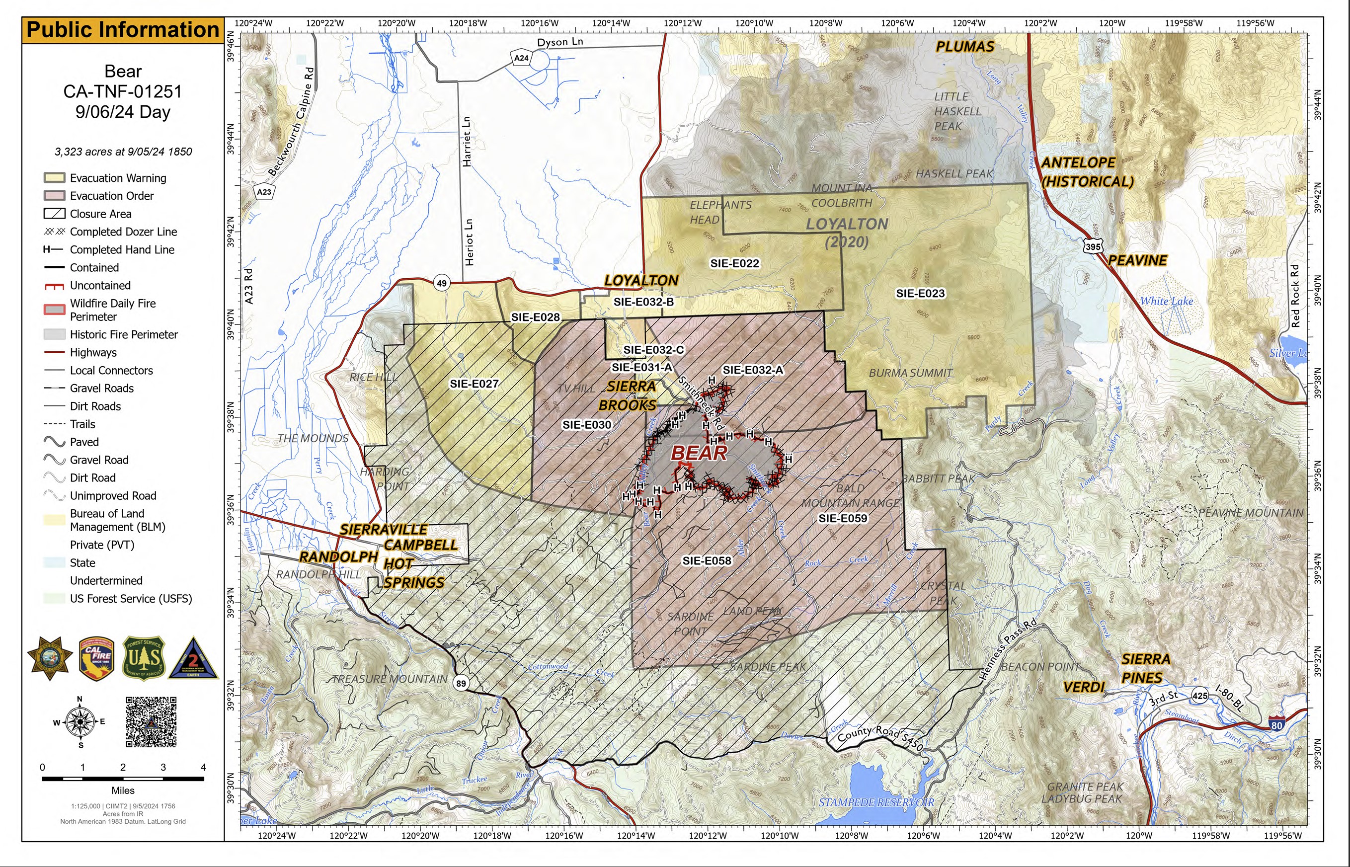
Bear Fire Incident Update 09 06 2024
Related Incident: Bear Fire, Tahoe National Forest
Publication Type: News
Location: South of Sierra Brooks off Bear Valley Rd., Tahoe National Forest
Personnel: 881
Start Date: 9/2/2024 @ 2:00 PM Cause: Undetermined
Size: 3,325 Percent contained: 15%
Our main goal on the Bear Fire is to protect the public with care and dedication. We're committed to ensuring the safety of both you and our firefighters while managing the fire to safeguard your forests, communities, and natural areas.
Yesterday, improved weather conditions allowed our fire crews to continue to secure mop up and buffer the fire zone. Teams were able to hike in and lay hose where safe, with continuous support from aviation throughout the day.
Overnight, the fire remained in its current footprint allowing crews to focus on improving the direct lines and hose lays installed during the day. Aircraft continued to assist throughout the evening.
Today, efforts will be continuing strengthening the existing lines and scouting new ones to reduce the fire’s impact on local communities and prepare for incoming weather. Crews will continue the mopping-up process, which involves extinguishing any remaining hot spots near control lines, removing hazardous burned trees, and assessing logs to prevent them from rolling and causing additional fires or smoke.
WEATHER:
Wind with a South-southeast flow is expected for the next several days with a breezy pattern throughout the area. This is a slight change from the previous few days, but winds are not expected to reach critical conditions. Temperatures will continue to warm. A pattern change will bring a 5% chance of thunderstorms east of the fire today, followed by increasing southwest winds this weekend into next week.
EVACUATIONS:
Sierra County: Repopulation of Sierra Brooks began yesterday afternoon. Evacuation warnings remain in effect. For an interactive map of evacuations, visit: https://protect.genasys.com/search.
FOREST CLOSURE:
A forest closure has been issued, For more information visit the Tahoe National Forest website at: https://www.fs.usda.gov/alerts/tahoe/alerts-notices.
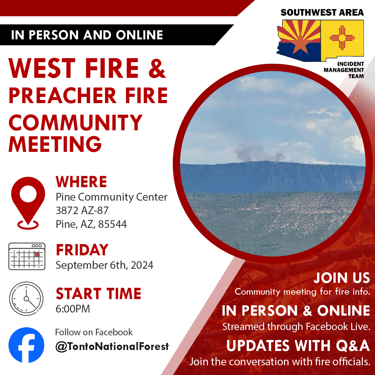
West Preacher Fires Update 09 06 2024
Related Incident: 2024 - West Fire - TNF2024 - Preacher Fire - TNF
Publication Type: News
Public Meeting scheduled for tonight in Pine, AZ
Highlights: The Tonto National Forest and SW Area Incident Management Team will be holding a public meeting on Friday, September 6, 2024 at 6 p.m. at the Pine Community Center 3872 AZ-87, Pine, AZ, 85544. The public meeting will be in person and streamed through the Tonto National Forest Facebook page: @TontoNationalForest. If by chance we run into problems streaming, the meeting will be recorded and uploaded to view later.
Operations:
West Fire - 28 Acres: Removal of fuels along Milk Ranch Road continues to be the focus of the work. Today masticators will continue preparing this road to be defensible and hold the fire within the identified containment area. Additional engines and crews are removing dead trees along roads to prevent them from catching fire or falling onto roads. A crew is also constructing firelines from Bray Creek Ranch north to the Rim. In Camp Geronimo vegetation is being cut back from roads and structures are being prepared with hose and sprinklers. Dozers and equipment will continue improving existing fuel breaks just west of Pine.
Preacher Fire - 3 Acre: Yesterday, crews finished preparing firelines north of the fire. The southern lines are nearly complete. Crews from the northside of the Preacher Fire will relocate to the southern side to help accomplish the remaining preparation. Engines continue to patrol the lines.
Both fires are being managed under a confine/contain strategy with the goal of reintroducing fire into a fire dependent ecosystem. The intended result of managing naturally caused fires are to reduce hazardous fuels, encourage the growth of native forage, improve range conditions, increase species diversity, protect and improve wildlife habitat, improve watershed conditions and restore ecological balance. The total planning areas for the West Fire includes 16,700 acres, for Preacher Fire 3,200 acres. This will decrease unnaturally high accumulations of fuels and the potential for future fires to burn with unnaturally high severity, aligning with the Forest Service Wildfire Crisis Strategy: https://www.fs.usda.gov/managing-land/wildfire-crisis.
Weather: Sunny and hot conditions persist with temperatures in the middle to upper 80’s. The relative humidity has fallen to around 20% and the wind is terrain driven at speeds less than 10 mph with gusts to 15 mph. The overall weather pattern will not change through the end of the week with hot and dry conditions. Low shower and thunderstorm chances are anticipated to return to the region on the weekend.
Safety: With the weekend upon us, we want to remind local and visitors to use caution with the additional fire traffic in and around the communities of Payson, Pine, Strawberry, Tonto Village, Star Valley, and Whispering Pines.
Closure: The Tonto National Forest has issued a closure for land surrounding the West Fire. https://inciweb.wildfire.gov/incident-publication/aztnf-2024-west-fire-tnf/us-forest-service-closure-order-for-west-fire-09-04-2024
Smoke: Smoke from the West and Preacher Fires may be visible in the surrounding areas for many days. Smoke will be heavier in the mornings as it settles into the lower elevations and will lift as temperatures increase. As temperatures increase the volume of smoke may increase due to the drying and ignition of available fuels. Smoke-sensitive individuals and people with respiratory problems or heart disease are encouraged to take precautionary measures. Learn more about smoke impacts on the. https://azdeq.gov/wildfire-faqs
For the latest news and information about the Tonto National Forest, follow along on Facebook @TontoNationalForest, ‘X’ (formerly Twitter) @TontoForest or Instagram @tontonationalforest and on the Tonto National Forest website: https://www.fs.usda.gov/tonto
Williams Mine Fire Update 09 06 2024
Related Incident: Williams Mine Fire-GPNF
Publication Type: News
Williams Mine Fire Update for Friday, September 6, 2024
A Red Flag Warning has been issued for the Williams Mine Fire area. This warning will remain in effect until 11:00 p.m. today. The warning was issued due to expected wind, low relative humidity, and unstable conditions. There is also a Heat Advisory through 9:00 p.m. Saturday.
Fire activity has increased the last couple of days and nights as fuels have dried out and become more receptive to burning. The winds from the east have helped the fire move west from the Morrison Creek drainage up Crofton Ridge. This and other burning areas produced ample smoke yesterday. During the afternoon, the smoke began to drift downslope into the valleys, obscuring Mt. Adams and producing poor air quality.
There have been large unburned islands inside the fire perimeter. The largest pocket, between Morrison Creek and Crofton Ridge, plus some smaller areas burned yesterday, pushed by the wind and backing into it. Most of these unburned pockets are expected to be cleaned up by the fire sooner or later. Since they are surrounded by areas that have already had the fire consume most of the fuels, these interior flareups are of little concern to fire personnel. These areas are monitored, but rarely merit any suppression actions.
A helicopter continues to drop water on the eastern edge of the fire in the Mt. Adams Wilderness, trying to slow this edge’s progression to the east. The objective is to keep the fire west of South Climb Trail and off of the Yakama Reservation.
FS Rd 23 is still closed while fire personnel complete work on it as a contingency line. Excavators and dump trucks are on the road moving limbs and brush and clearing ditches. A hand crew will be working along the road, cutting brush that machines couldn’t reach safely.
SAFETY AND CLOSURES:
A Red Flag Warning indicates that conditions may be favorable for rapid fire spread which may threaten life and property. Use extra caution with potential ignition sources, especially in grassy areas.
The Confederated Tribes and Bands of the Yakama Nation, Tract D Recreation Area is currently closed, please see Yakama Tract D Road Closure for more information. FS Rd 23 south of FS Rd 90 is still CLOSED to the public due to fire suppression activity. Takhlakh Lake is still closed. The revised closure for the Mt. Adams Wilderness and FS Rd 23 closure can be found at Williams Mine Fire: Area and Road Closure. The Pacific Crest Trail (PCT) is closed from the PCT's intersection with FS Rd 23 to Potato Hill. The current area closure spans the entire Mt. Adams Wilderness.
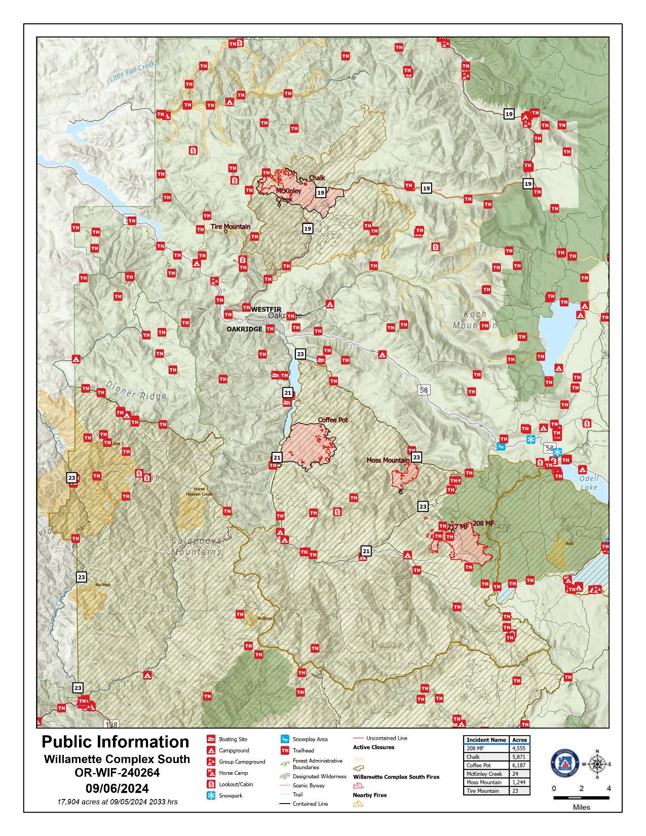
Willamette Complex South Daily Update for Friday Sept 6th 202409 06 2024
Related Incident: Willamette Complex Fires - South
Publication Type: News
Willamette Complex South Update
Chalk, Coffeepot, McKinley, Moss Mountain, Tire Mountain, 208, and 217 Fires
Online: https://inciweb.wildfire.gov/incident-information/orwif-willamette-complex- fires-south
Facebook: https://www.facebook.com/WillametteComplexFires/
Email: 2024.willamettecomplex@firenet.gov Information Line: 541-208-1742
Friday, September 6, 2024 Fire Cause: Lightning
Total Willamette Complex South Personnel: 619
Total Willamette Complex South Acres: 15,446
Resources: 2 Type 1 Hotshot crews, 7 Type 2 crews, 2 Type 2 initial attack crews, 3 helicopters, 14 engines, 4 dozers, 72 heavy equipment (masticators, skid steers, feller bunchers, etc.)
Community Meeting Saturday, September 7th, 2024, at the Middle Fork Ranger Station at 6:30 PM PST. The meeting will be in person with a virtual option on the fire’s Facebook; the recording will be posted thereafter.
Summary East winds in the overnight hours further accelerated fire activity. High temperatures and low relative humidity today will further the burning of heavy fuels. The Red Flag Warning for the area was extended into this evening due to ongoing critical fire weather and a potential for afternoon lightening. The incident's number one priority for the day will be supporting local resources with initial attack with the potential for new starts. Firefighters continue to progress with containment efforts including patrolling, mop-up, holding existing line, and developing line.
Chalk Fire (5,871 acres, 86% containment) Progress towards containment on the north and west edges of the fire is ongoing. Firefighters are actively monitoring unburned areas. Further reinforcement of the fire’s edge to build and hold containment continues.
Moss Mountain Fire (1,244 acres, 12% containment) Progress on indirect lines to the north and a contingency line to the south of the fire are progressing. Line along Forest Service Road 2120 is holding as firefighters anchor the fire westward from there to existing line. A spot over the line to the south has been secured.
208 Fire (4,555 acres, 0% containment) Elevated fire activity has compromised previously identified lines. Three Type 1 Hotshot crews and the support of all available aircraft are working to slow rate of spread and develop new strategic plans towards containment. Active flanking is anticipated around all portions of the fire perimeter except rocky portions within the wilderness and areas to the north, northwest where previous fuels treatments are slowing the rate of spread.
Coffeepot Fire (6,187 acres, 100% contained), McKinley Creek Fire (24 acres, 100% contained), Tire Mountain Fire (23 acres, 100% contained) Firefighters remain vigilant with their monitoring and patrolling of these fires to ensure they remain fully contained. Work to improve the depth of mop-up along the contained edges and to identify hazards continue. The 217 fire has been consumed by the 208 fire and will no longer be listed.
Weather and Fire Behavior Temperatures continued to rise Thursday for afternoon highs in the upper 90s. Relative humidities fell into the teens and did not recover through the evening. High temperatures are expected to remain today prior to declining into the weekend with temperatures predicted in the upper 70s for Sunday. There is a chance of scattered and isolated thunderstorms over the area this afternoon into the evening. The Red Flag Warning has been extended through evening due to an unstable atmosphere, critical relative humidity values, and the chance for thunderstorms.
Smoke Information
For local air quality information and actions to take, visit: https://fire.airnow.gov.
Closures and Fire Restrictions
- For specific closure information, visit tinyurl.com/WillFireClosures2024
- For current fire restrictions, visit tinyurl.com/WillFireRestrictions2024
- Temporary Flight Restrictions (TFR): tfr.faa.gov for up-to-date areas. Wildfires are a no-fly zone for unauthorized aircraft, including drones. For more information, visit knowbeforeyoufly.org.
West Mountain Fires Daily Update 09 06 2024
Related Incident: Dollar Fire
Publication Type: News
Fire Location Size Containment Assigned Personnel Inciweb Link
Boulder 6 miles SW of Cascade 3,957 24% 462 https://tinyurl.com/ycdfv3tv
Snag 11 miles E of Cascade 32,478 13% 449 https://tinyurl.com/4k9dk3mu
Dollar 18 NE of Cascade 4,170 3% 15 https://tinyurl.com/bef6r3tz
Goat 11 miles SE of Cascade 4,613 0% 102 https://tinyurl.com/2h4a3dvr
Cause: Lighting (All Fires) Total Incident Personnel 1028
Special Announcement:
Rocky Mountain Complex Incident Management Team Three assumed command of the West Mountain Fires this morning at 6 a.m. Incident Commander Bill Waln and Team Three look forward to serving your communities.
Weather | Anticipated Fire Behavior:
A high-pressure system remains over the fire area again today. Temperatures will stay between the low 70’s and mid 80’s and winds will remain light and mainly terrain driven. Expect smoke to linger over Cascade and up through McCall. Relative humidity will remain low, and fire activity should be moderate. It is likely that these fires will continue to burn until a season-ending weather event. Historic average indicates this will occur around mid-October.
Army crews from the 14th Brigade Engineer Battalion based at Joint Base Lewis McChord are imbedded with fire crews working to secure line on the Boulder Fire and Snag Fire, and soldiers are also assisting with radio operations.
Boulder Fire: “Set” and “Ready” evacuation orders are in effect. Learn more at Valley County Sheriff on Facebook.
- Yesterday, hand crews made significant progress in the Olson Creek and Brush Creek drainages nearly connecting two separate indirect handlines. Other fuel breaks on the northern edge were established using dozers and heavy equipment, connecting roads above the Willow Creek subdivision to the 4 Corners fire footprint. The structure protection group continued to build a plan of action for the Willow Creek subdivision.
- The night shift remains staffed, with fire engines patrolling for hotspots and monitoring fire behavior.
- Today, firefighters and heavy equipment will keep constructing containment line between the fire and residences. Crews are working to complete handline in the Olson Creek drainage. Depending on fire and weather conditions, aviation resources will be used again today to support these efforts on the ground.
Dollar Fire:
- Fire growth was again minimal on the Dollar Fire, with mostly some creeping behavior in the north near rocky terrain. The fire is being monitored, and crews are removing unneeded equipment in this area.
Snag Fire:
- Warm Lake Road remains open from 9 a.m. to 6 p.m. with one lane of traffic and a pilot car for individuals vetted through the Valley County Sheriff’s department. Go slow and safely; firefighters are working along the roadway.
- Resources are holding and improving the fire’s edge along the Warm Lake Rd, 409 Clear Creek Rd and the West Flank of the fire. Yesterday, the fire consumed some unburned fuel in this area; increased smoke may have been visible due to this activity.
- Heavy equipment continues to improve and remove fuel from the road systems on the west side of the Warm Lake subdivision. Engines remain stationed around the subdivision for structure protection.
Goat Fire:
- The Goat Fire had minimal growth yesterday. Crews caught a spot fire over the containment line on the north end and continue securing it today. Crews will monitor the fire’s growth to the north and south looking to utilize the 099 trail to prevent the fire from spreading to the west.