
BLACK EAGLE FIRE CLOSURE INCLUDES RED ROCK FIRE 09 06 2024
Related Incident:
Publication Type: Closures
The Salmon‐Challis National Forest has implemented the Black Eagle Fire Closure, Order Number: 04‐13‐24‐019.
Description of #04-13-24-019:
DESCRIBED ROADS
NFS lands, roads and trails on the Salmon-Cobalt, and North Fork Ranger Districts of the Salmon-Challis National Forest within the area bounded by the following: Beginning at the intersection of Blackbird creek with Panther Creek, following Blackbird creek to Blackbird mountain, then following FS Road 33 to the Frank Church River of No Return Wilderness Boundary and following the boundary to the Golden Trout Lake Trailhead, including the Big Horn Crags Campground and crossing over into the Frank Church River of No Return Wilderness and onto the ridge to the West of Wilson Creek, then going South to Middle Fork Peak. From Middle Fork Peak to the Frank Church River of No Return Wilderness Boundary to trail 053 then running along Little Jacket Creek to Trail 051, then following Trail 051 to Birdseye Creek to Forest Road 245 at its intersection with Panther Creek road 55. Then following the western side of FS Road 55 (Panther Creek) until it reaches Blackbird Creek. Panther Creek road (55) and Blackbird road (115) will remain open within the scope of this order.
UPDATE 09-06-24: Closures now include all lands and associated roads within McDonald Flat Campground
The purpose of this order is to protect public health and safety during the Black Eagle/Red Rock Fire.
This Order shall be in effect from September 3, 2024, at 8:00 am until rescinded.
Visit our website at: www.fs.usda.gov/scnf/, ‘Like Us’ on Facebook @salmonchallisnf, and ‘Follow Us’ on X @salmonchallisnf.
####
Middle Fork Complex Daily Update for Wednesday 09 04 2024
Related Incident:
Publication Type: News
Fire Size: 57,466 Acres
Completion: 23 percent
Resources: 911 Personnel
Community Meeting:
A community meeting is scheduled for today September 4th, at 6 p.m. at the White Barn Building, near 85 Severance Road, Garden Valley, Idaho. Great Basin Complex Incident Management Team (CIMT) 3 will introduce the incoming Great Basin CIMT 5 to the community, provide the latest fire updates, and address any questions.
Weather and Fire Behavior:
A high-pressure system will return to the region, resulting in warmer temperatures and light winds in the valleys throughout the day. In the afternoon, ridgetop winds will come from the Northwest. An inversion will be present in the area for much of the morning but is expected to gradually lift in the afternoon. As a result, surrounding communities will experience smoky conditions in the morning. The inversion will help moderate fire conditions, and fire behavior analysts predict minimal fire activity today, with low rates of spread.
Operations:
Containment refers to the amount of fire perimeter that is surrounded by a control line that fire managers are confident the fire will not cross. Crews have successfully added containment to several areas on both the Bulldog and Nellie fires. The moderate fire conditions over the past few days have allowed crews to prioritize improving and constructing direct and indirect lines.
The west side of the Bulldog Fire along the Middle Fork Road remains secure. Crews continue to focus their efforts on structure preparation in the Silver Creek area and are assessing fire movement in the Lightning Creek drainage.
Mop-up, the process of thoroughly extinguishing or cooling down remaining hotspots within a specified distance of the fire line, continues on the west side of the Nellie Fire. Crews are detecting less heat each day in this area and are working their way northwest towards the Bulldog Fire to complete the fire line aimed at keeping both fires north of the 668 Road. Fire lines near the Deadwood Reservoir are holding steady. A major focus near Deadwood is constructing lines to direct the fire into previously burned areas. The decreased fuel availability in these burn scars significantly reduces the fire's intensity as it moves through them. Some unburned fuel remains in some areas of these old burn scars. As the fire encounters these areas, it may continue to burn through them, but slowly and at a low intensity.
Closures:
The Boise National Forest has issued Order Number 0402-06-60, effective August 23, 2024. Highway 21 is closed from the Sourdough Lodge in Lowman to Stanley (MP 84 to 130) due to wildfire activity. For additional information, visit https://511.idaho.gov/
Temporary Flight Restrictions (TFR):
A TFR is in effect over the fire area. It is illegal for the public to fly drones over or near wildfires due to the risk of accidents and interference with firefighting efforts.
House Draw Fire Daily Update for September 4 2024 09 04 2024
Related Incident: House Draw Fire
Publication Type: News
Crews continue repair work, last day to request assistance on private land
Daily Update September 4, 2024
Fire Information Phone: 307-201-3885 (8 a.m. – 8 p.m.)
Media Information Phone: 307-543-7202 (8 a.m. – 8 p.m.)
Suppression Repair Phone: 307-303-7642 (8 a.m. – 8 p.m.) This line is for private landowners to report repair needs of heavy equipment line or cut fence that occurred during fire suppression efforts. Be aware this phone line will be unstaffed starting Wednesday, September 4, 2024, at 8:00 p.m.
Email: 2024.housedraw@firenet.gov
Acres: Flat Rock – 52,421; Remington – 196,368; Constitution – 24,630; House Draw – 174,547; Silver Spoon – 1,721
Acreage changes may occur due to overnight operations and infrared mapping.
Containment: Flat Rock – 97% Remington – 88%; Constitution – 95%; House Draw – 94%; Silver Spoon – 42%
Location: Flat Rock – 11 miles northwest of Gillette, WY; Remington – 14 miles northeast of Leiter WY, multiple counties in southeast MT; Constitution – 11 miles northeast of Gillette, WY; House Draw – 9 miles southeast of Buffalo, WY; Silver Spoon – 37 miles north of Gillette, WY
Start Date: August 21, 2024 Personnel: 586 Fuels: Grass, brush and timber
Resources: 11 crews | 52 engines | 18 water tenders | Heavy Equipment
Highlights: Thanks to the hard work of firefighting crews and heavy equipment operators on the Flat Rock, Remington, Constitution, House Draw and Silver Spoon fires, over 50% of constructed fireline has been repaired.
Fire Activity: Thunderstorms moving through the area will bring much cooler temperatures, decreasing the chances of new starts. Fire activity is minimal across all fires, with firefighters patrolling firelines, repairing fences and assisting heavy equipment operators with fireline repair. Isolated pockets of trees inside containment lines may create visible smoke but should not pose a threat to firelines.
Silver Spoon – Firefighters on the Silver Spoon Fire spent yesterday scouting for heat sources. Today, crews and engines will patrol firelines and begin mop-up.
Flat Rock – Heavy equipment continued working from the north end of the Flat Rock Fire south along the perimeter to Mongomery Road. Today, crews and equipment will continue working south, and repairing fences where needed.
Remington – Crews worked with heavy equipment to build water bars, and repair firelines and fences along the eastern side of the fire. Today, heavy equipment and crews will continue working south moving toward the southeast corner of the fire.
Constitution – Yesterday, graders worked north to south on the Constitution Fire and are nearing completion of machinery work on the northeast side. Today, heavy equipment will continue working south on the western flank, with crews completing fence repair as needed.
House Draw – Heavy equipment finished up work on the western side of the Horse Draw Fire, south of Interstate 90. Today, crews will continue suppression repair work as graders and other heavy equipment move to the north side of the interstate.
Weather: The fire area will see cloud cover with isolated to scattered showers and thunderstorms. Temperatures will be considerably cooler, dropping into the 70s.
Fire Restrictions and Closures: Fire Restrictions are in place across the fire area including:
- The Custer Gallatin National Forest (Powder River and Rosebud Counties, Montana) implemented road closures within the Remington Fire burned area located on National Forest System lands, effective August 30, 2024. More information available at https://www.fs.usda.gov/Internet/FSE_DOCUMENTS/fseprd1202405.pdf.
- Stage 1 Fire Restrictions for Custer Gallatin National Forest, Ashland Ranger District (effective August 1, 2024). More information available at https://www.fs.usda.gov/alerts/custergallatin/alerts-notices/?aid=89447.
- Stage 1 Fire Restrictions for Bureau of Land Management Buffalo Field Office in Johnson County (as of July 1, 2024) and Campbell and Sheridan Counties (as of July 9, 2024). More information available at https://www.blm.gov/programs/public-safety-and-fire/wyoming/fire.
- Stage 1 Fire Restrictions for Sheridan, Campbell and Johnson Counties in Wyoming (as of July 9, 2024). More information available at https://wsfd.wyo.gov/fire-management/fire-restrictions.
- Stage 1 Fire Restrictions for Thunder Basin National Grasslands within the Douglas Ranger District in Converse, Campbell, Crook, Natrona, Niobrara, Platte, and Weston counties in the State of Wyoming (as of August 7, 2024). More information available at https://www.fs.usda.gov/detail/mbr/news-events/?cid=FSEPRD1199001.
- The Medicine Bow-Routt National Forest implemented a temporary closure of the popular Weston Recreation Area on the Thunder Basin National Grasslands within the Constitution Fire (Johnson County, WY), effective August 23, 2024. More information available at https://www.fs.usda.gov/Internet/FSE_DOCUMENTS/fseprd1201513.pdf.
More Information:
InciWeb (House Draw Fire): https://inciweb.wildfire.gov/incident-information/wyhpd-house-draw-fire
InciWeb (Remington Fire): https://inciweb.wildfire.gov/incident-information/mtgnf-remington-fire
Public Information Linktree: https://linktr.ee/housedrawfire
Facebook: https://www.facebook.com/SWIMT5/
Limepoint Fire Daily Update September 4 2024 09 04 2024
Related Incident: Limepoint Fire
Publication Type: News
Limepoint Fire
Wednesday, September 4, 2024
Contacts for Fire Information:
208-992-3032 or 2024.limepoint@firenet.gov
https://inciweb.wildfire.gov/incident-information/idpaf-limepoint-fire
https://www.facebook.com/payettenationalforest/
The Limepoint Fire added a few acres overnight, again due to a combination of infrared mapping and interior fires consuming fuels. Containment increased slightly to 95%. The crews did an outstanding job of keeping the fire within its containment lines through Monday’s and Tuesday’s turbulent weather.
Crews continue to reinforce the perimeter on the northeast side of fire. The rest of the fire remains in a patrol and monitor status. All suppression repair work that can be done at this time has been completed. Once the fire reaches 100% containment, suppression repair operations will continue. Currently there is one road grader working in the Limepoint Fire area near Placer Basin on the northeast side of fire.
Wednesday will begin another warming and drying trend as the low exits east and a ridge of high pressure aloft rebuilds behind it. Winds today will start to moderate and primarily be out of the north. Temperatures will rise Wednesday through Saturday in response to the strong high-pressure ridge. Dry conditions and light winds will prevail. Expect the inversion to lift early each afternoon as the warming and drying conditions and widespread smoke continue to move in from fires in central Idaho.
Evacuations: Cuprum remains at a Level 1 (READY) evacuation level.
Closures: The Forest Closure Order updated Monday, August 26, 2024, at 7:00 a.m. Some areas previously closed to the public have been reopened. For details about the closure, visit https://www.fs.usda.gov/alerts/payette/alerts-notices. There is still a lot of work being done in the fire area; for your safety and the safety of firefighters, please observe the existing Payette Forest Closures still in effect and watch out for firefighters and fire traffic.
Restrictions: Effective 12:01 a.m. on Friday, August 30, 2024, Stage 1 fire restrictions were lifted. There are currently no fire restrictions in place, but visitors are reminded that vegetation is still dry and to be careful with all use of fire outdoors.
FIRE SUMMARY SEPTEMBER 03 2024 09 03 2024
Related Incident:
Publication Type: News
There have been seven (7) new fires reported on the Salmon-Challis National Forest since the last update on Monday, August 26, 2024. To date, there have been 47 wildfires reported on the Salmon-Challis National Forest. 34 of the fires have been declared out.
Moyer (September 3) is located approximately 25 miles southwest of Salmon on the Salmon-Cobalt Ranger District. Two (2) firefighters are on scene working to suppress the 0.10 acre fire burning in a single tree.
Kinnikinic (September 3): is located approximately 13 miles southwest of Challis on the Challis-Yankee Fork Ranger District. Two (2) firefighters are on scene of the 0.10 acre fire which is contained.
Vanity (September 3): is located approximately 42 miles west of Challis on the Middle Fork Ranger District. The two (2) acre fire is burning in subalpine fir is surrounded by the 2012 Halstead Fire.
Silver (September 2): is located approximately 35 miles southwest of Salmon on the Salmon-Cobalt Ranger District. Two (2) firefighters are on scene working to suppress the 0.25 acre fire.
Shovel (September 2): is located approximately one (1) mile northeast of Yellowjacket Guard Station on the Salmon-Cobalt Ranger District. The 0.10 acre fire is out.
Phelan (September 2): is located west of the Ridge Road #020 approximately nine (9) miles west of Salmon on the Salmon-Cobalt Ranger District. The fire is estimated at three (3) acres burning in lodgepole pine. Resources are on scene working to suppress the fire.
Red Rock (September 2): is located approximately two (2) miles east of Yellowjacket Guard Station on the Salmon-Cobalt Ranger District. The fire is estimated at 100-200 acres burning in Douglas fir and lodgepole pine. Resources are on scene and additional resources are on order. A Type III Incident Management Team has been ordered to manage the Red Rock and Black Eagle Fires.
Reynolds (August 22): is located approximately 21 miles northwest of Indianola, approximately 5.5 miles northwest of Horse Creek Hot Springs Campground on the Idaho/Montana border. Fire is estimated to be approximately 27 acres burning in spruce and fir. The Bitterroot National Forest is lead on this fire.
Birch (August 17): is located on the west side of the Middle Fork of the Salmon River on Norton Ridge on the Middle Fork Ranger District in the Frank Church River of No Return Wilderness. The 66 acre fire is burning in subalpine fir. The fire is surrounded by the 2022 Norton Fire and fire scars from the fires of 2000.
Hammer (August 16): is located approximately four (4) miles east of North Fork between Wagonhammer and Little Fourth of July Creeks on the North Fork Ranger District. The fire is estimated at 8 acres in size. The fire is out.
Sugarloaf (August 16): is located approximately 34 miles west of Salmon on the North Fork Ranger District in the Frank Church River of No Return Wilderness. The 0.25 acre fire is burning in subalpine fir is out.
Greyhound (August 11): is located approximately 46 miles northwest of Challis on the Middle Fork Ranger District. The 63 acre fire is burning in subalpine fir and lodgepole pine. The fire is backing down until Sulphur Creek at the edge 2021 Boundary Creek Fire. Firefighter and public safety is the number one priority for the Greyhound Fire. During initial size up for the fire, several safety concerns were identified including: the remote location of the fire, steep and inaccessible terrain, heavy dead and down fuels with a substantial snag component, private property and associated mining infrastructure, and lack of safe ingress and egress for firefighters. Fire managers will be monitoring the fire with reconnaissance flights and lookouts. NFS Road #011 is a one way in, one way out roadway and is is closed for public safety, closure can be found at https://www.fs.usda.gov/Internet/FSE_DOCUMENTS/fseprd1201939.pdf.
Black Eagle (August 5): is located approximately 12 miles west of Forney on the North Fork Ranger District in the Frank Church River of No Return Wilderness. The 2,000 acre fire is burning in lodgepole and subalpine fir. The fire is active, backing with short-range spotting, and short crown runs and is being monitored by aircraft and lookouts. A Type III Incident Management Team has been ordered to manage the Black Eagle and Red Rock Fires. Due to increased fire activity on the Black Eagle Fire, the Hoodoo Meadows Trail (#043) is currently closed from the Hoodoo Meadows Trailhead and all points in-between until it intersects with Forest Service Road 112 near Middle Fork Peak. For information on the current status of this closure please contact the North Fork Ranger District at (208)-865-2700.The Black Eagle Fire can be found on InciWeb at https://inciweb.wildfire.gov/incident-information/idscf-black-eagle-fire.
Deer (July 25): The lightning fire is located approximately 33 miles northwest of Challis, southeast of Pinyon Peak on the Middle Fork Ranger District in the Frank Church River of No Return Wilderness. Loon Creek Guard Station is east of the fire. The fire, burning in grass and conifers is estimated at approximately 54 acres. The fire is burning on both side of Rabbit Creek, in the 2006 Trail Creek Fire. Fire managers are using a point protection strategy (a wildfire response strategy, which protects specific assets or highly valued resources from the wildfire without directly halting the continued spread of the wildfire) to minimize exposure to fire personnel while protecting identified values. The strategy takes into account exposure to firefighters, values at risk, and wilderness values. Specific values potentially threatened with this fire include private land and Forest Service infrastructure.
Thunder (July 24): The lightning fire is located approximately two (2) miles northwest of Williams Lake and approximately 12 miles southwest of Salmon. The fire is 100% contained and estimated to be 2,474 acres in size and is burning in timber, sagebrush, and grass.
Weather: ...RED FLAG WARNING IN EFFECT UNTIL 5 PM MDT THIS AFTERNOON FOR SCATTERED THUNDERSTORMS...A Red Flag Warning remains in effect until 5 pm for scattered thunderstorms. Dry conditions are expected Wednesday through Saturday with monsoonal moisture and a chance for thunderstorms returning Sunday.
The forest is asking visitors to be aware of the fire danger for the Salmon-Challis National Forest. Ensure your campfire is dead out. If it is too hot to touch, it is too hot to leave! One Less Spark Means One Less Wildfire. Since June 1, Forest employees have found and extinguished at least 13 abandoned campfires.
Nationally, there are 51 uncontained large fires being managed under a full suppression strategy and 22 large fires managed under a strategy other than full suppression.
Visit our website at: www.fs.usda.gov/scnf/, ‘Like Us’ on Facebook @salmonchallisnf, and ‘Follow Us’ on X @salmonchallisnf.
Copperfield Fire Evening Update for 932024 09 04 2024
Related Incident: Copperfield Fire
Publication Type: News
EVENING UPDATE FOR THE COPPERFIELD FIRE – SEPT. 3, 2024
Chiloquin, OR – The Copperfield Fire is now completely lined. Additional crews that arrived overnight and today bolstered efforts to surround the fire and will now work to strengthen the perimeter to prevent future escape. Total personnel on the fire has now reached 534 working both on the day and night shift crews. Overnight, crews will identify hot spots around the fire and continue the work the day crews started.
The Klamath County Sheriff's Office updated their evacuation levels earlier today. Current evacuation areas and levels can be found at https://www.klamathcounty.org/300/Emergency-Management.
Work to clear hazardous trees along the Sprague River Highway is now complete. The highway will open to the public at a reduced speed at 5:00 a.m. Wednesday morning, September 4th. Motorists are advised to continue to exercise caution when driving through the area due to increased fire traffic in the area.
This will be the final evening update for the Copperfield Fire.
Settings - change map background and toggle additional layers
Filter - control incident types displayed on map.
Zoom to your location
Reset map zoom and position
Could not determine your location.
Show Legend
 Wildfire
 Prescribed Fire
 Burned Area
Response
Burned Area
Response Other
Other
2024 - West Fire - TNF
Unit Information
Incident Contacts
Shoe Fly Fire Evening Update 09 03 2024
Related Incident: Shoe Fly Fire
Publication Type: News
Shoe Fly Fire grows overnight, ODF Team 1 takes command
MITCHELL, Ore. – As of 6 p.m. Tuesday, September 3, 2024, Oregon Department of Forestry’s (ODF) Incident Management Team 1 assumed command of the Shoe Fly Fire. The fire was first reported early Monday morning, burning in grass, brush and timber north of Highway 26 near Girds Creek. Firefighters from ODF’s Central Oregon District, Wheeler County Fire and Rescue, Bureau of Land Management (BLM), and Twickenham Rangeland Fire Protection Association initially responded, along with local landowners.
Numerous fires were reported following thunderstorms late Sunday evening and overnight. Many of these fires were caught during initial attack. Near record-dry fuel conditions challenged firefighters on the Shoe Fly Fire, combined with limited available resources and erratic winds from passing thunderstorms on Monday. This resulted in growth on all flanks of the fire and prompted burning throughout the night. Infrared imagery Tuesday morning mapped the fire at 20,247 acres.
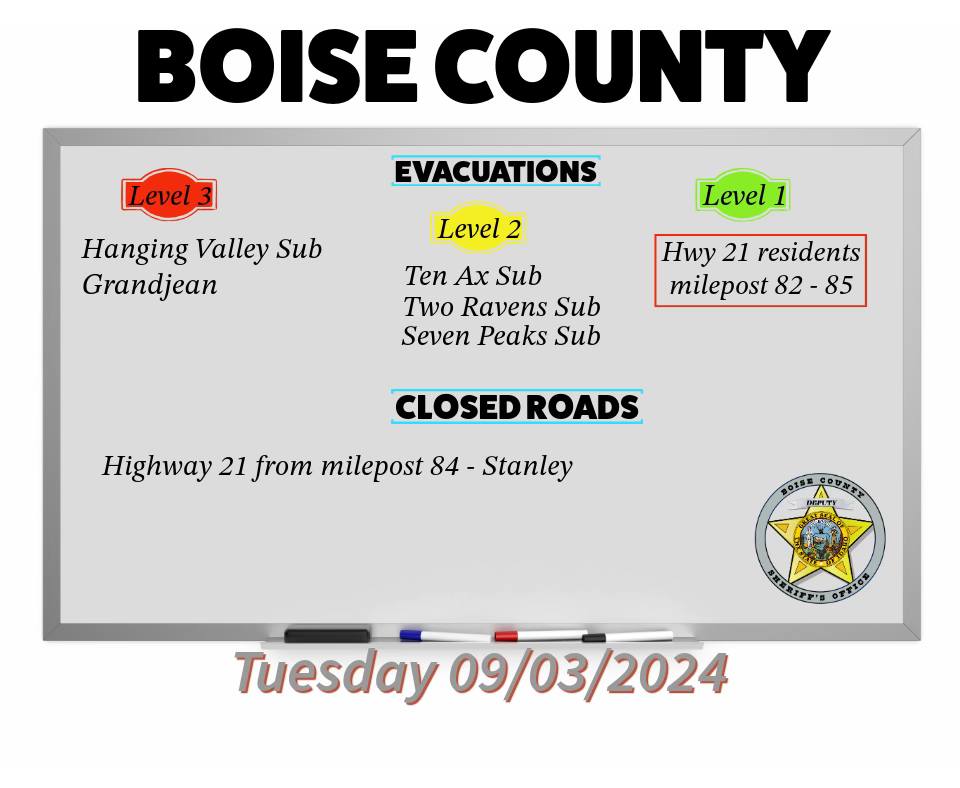
Boise County Sheriffs Office Has Downgraded Evacuation Locations 09 03 2024
Related Incident:
Publication Type: Announcement
The Boise County Sheriff's Office has downgraded all Middle Fork complex locations to "No" evacuation levels. They have also downgraded the Danskin Station area to "No" evacuation levels at this time.
Emergency Evacuation Alert from Fremont County Emergency Management 09 03 2024
Related Incident:
Publication Type: Announcement
3:48pm on September 3, 2024
Fremont County Emergency Management Agency has issued a Ready-Set-GO, Level 3 Notice
Due to the Fish Creek Fire, an immediate evacuation is required for the following areas: Brooks Lake Rd, East & West Pinnacle Dr., Breccia Dr.
To All Residents:
Due to an increasing wildfire threat in your area, this is a LEVEL 3 Notice (GO).
**EMERGENCY EVACUATION ALERT**
*This is an urgent message from Fremont County Emergency management*
*All residents must evacuate immediately. Follow these instructions*
1. Leave your home or dwelling immediately.
2. Take only essential items (medications, important documents, pets, etc.).
3.Check in with neighbors or those in need of assistance.
4. Listen to local authorities for further instructions.
**For more information and updates, tune in to local media, or the United States Forest Service**
**Please take action now*
Please take this notice seriously and be prepared to act quickly.
Your safety is our top priority.