
West Mountain Fires Daily Update 09 03 2024
Related Incident: Boulder FireDollar Fire
Publication Type: News
September 3, 2024
Fire Information Phone Line: 208-462-0345 (8 a.m. - 8 p.m.) Email: 2024.Boulder.id@firenet.gov
QUICK FACTS
Fire Location Size Containment Assigned Personnel Inciweb link
Boulder 9 miles SW of Cascade 2,868 acres 36% 401 https://tinyurl.com/ycdfv3tv
Snag 11 miles E of Cascade 31,809 acres 1% 425 https://tinyurl.com/4k9dk3mu
Dollar 18 miles NE of Cascade 4,010 acres 0% 61 https://tinyurl.com/bef6r3tz
Goat 11 miles SE of Cascade 3,265 acres 0% 124 https://tinyurl.com/2h4a3dvr
Cause: Lightning (All Fires) Total Incident Personnel: 1,011
Weather | Anticipated Fire Behavior:
Yesterday was another active day on all four of the West Mountain fires. Today, there is a possibility of scattered showers and thunderstorms, with 25 mile per hour winds shifting from southwest to northwest over the day. With increased cloud cover, temperatures will be cooler and relative humidity higher than yesterday. Skies clear overnight, with cooler temperatures and increased relative humidity recovery. Fire behavior is expected to moderate with weather.
- Army crews from the 14th Brigade Engineer Battalion based at Joint Base Lewis McChord are currently assisting with suppression efforts on the West Mountain Fires as well as assisting with adjacent wildfires in the area.
Boulder Fire: Evacuation orders are in effect. Learn more at Boulder Fire | Inciweb.
- The Boulder Fire progressed to the east and west in the Olson Creek drainage yesterday, as well as toward Blue Lake. Firefighters with four Army crews created indirect containment line to tie in with Forest Road 446 on National Forest System lands between the fire and residential areas, and structure assessment was initiated in the Willow Creek subdivision. Scoopers and Type 1 helicopters were used to slow the fire’s progression.
- Today, indirect line construction will continue using hand crews and heavy equipment from Forest Road 404 to 464. Aviation resources will be used again today, depending on weather conditions and aircraft availability.
- Fire managers coordinated with the Valley County Office of Emergency Management and the Valley County Sheriff’s Office to establish evacuation zones, including four zones in “go” status and two in “set” status.
Dollar Fire:
- Two Army crews supported firefighting efforts on the Dollar Fire yesterday.
- Firefighters completed a 5-acre burnout operation yesterday evening along the fire’s southwestern edge, where increased fire behavior threatened containment lines. They continue to mop up and patrol the area today.
Snag Fire:
- Yesterday, at the fire’s north end, crews continued to patrol and mop up hot spots along the Warm Lake Road, making the road safe for travel. The powerline was re-energized yesterday. Warm Lake Road will open today with one lane of traffic and a pilot car for residents of the Yellow Pine and Warm Lake areas.
- The Snag Fire grew slowly along its eastern flank yesterday, moving into previously burned areas where minimal fuels will help limit fire growth. A strike team of engine crews is beginning to assess structure needs for fuels mitigation and placement of sprinklers, hoses, and pumps in the Warm Lake area.
- Along the fire’s southern edge, crews mopped up and patrolled along Forest Road 409, keeping fire north of the road, and they were able to contain three spot fires south of the road yesterday. This activity continues today.
- Firefighters, along with four Army crews, continue to secure and mop up along the fire’s western flank.
Goat Fire:
- There was minimal growth along the southern edge of the Goat Fire yesterday.
- Crews continue preparing Forest Service Trail 099 as a holding feature and will continue to assess the need to fire from trail 099 either to the north or south of the fire if it approaches the trail at the top of the ridge.
Smoke: Find air quality and smoke information at: www.wildlandfiresmoke.net and www.airnow.gov/air-quality-and-health
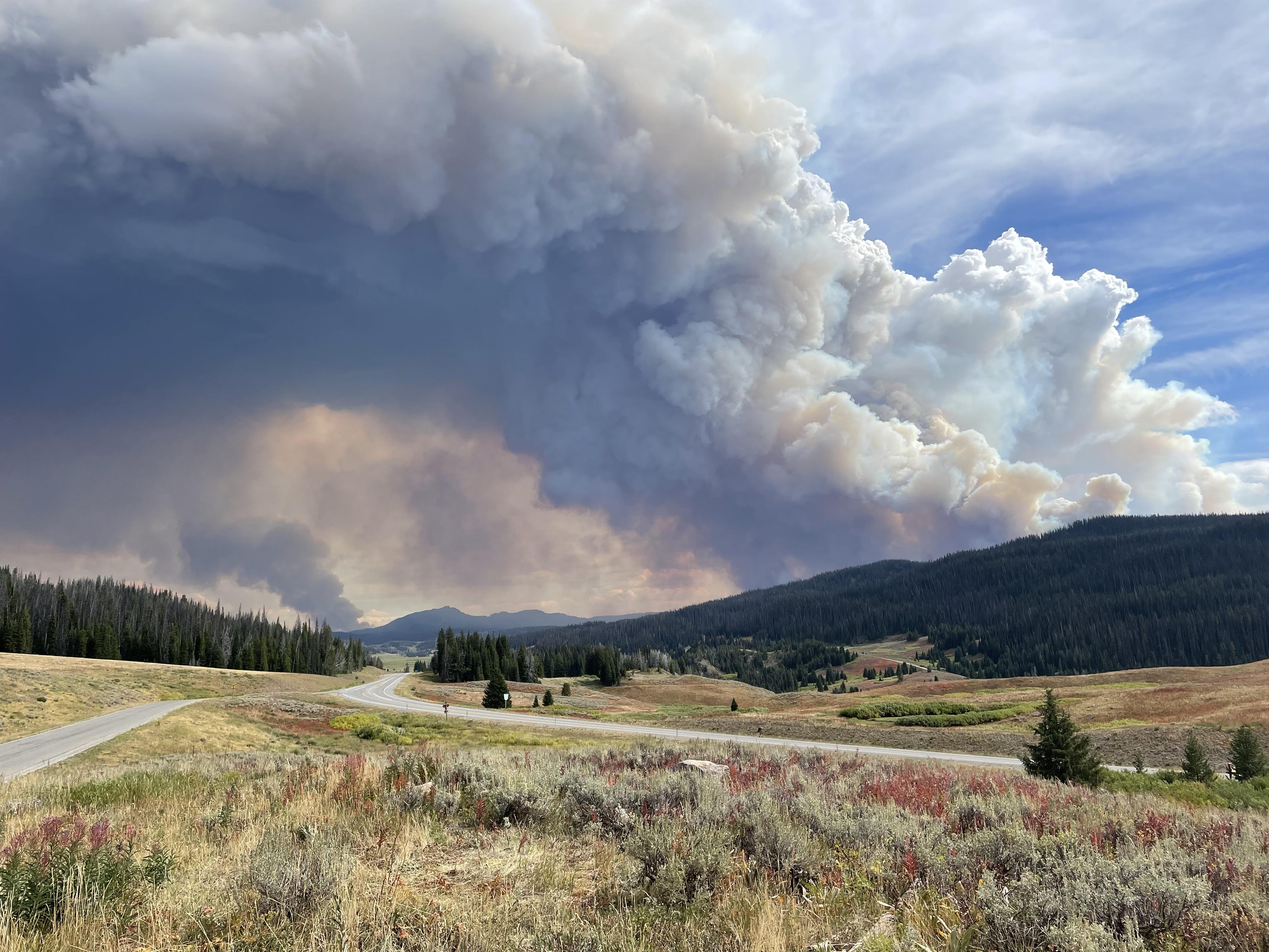
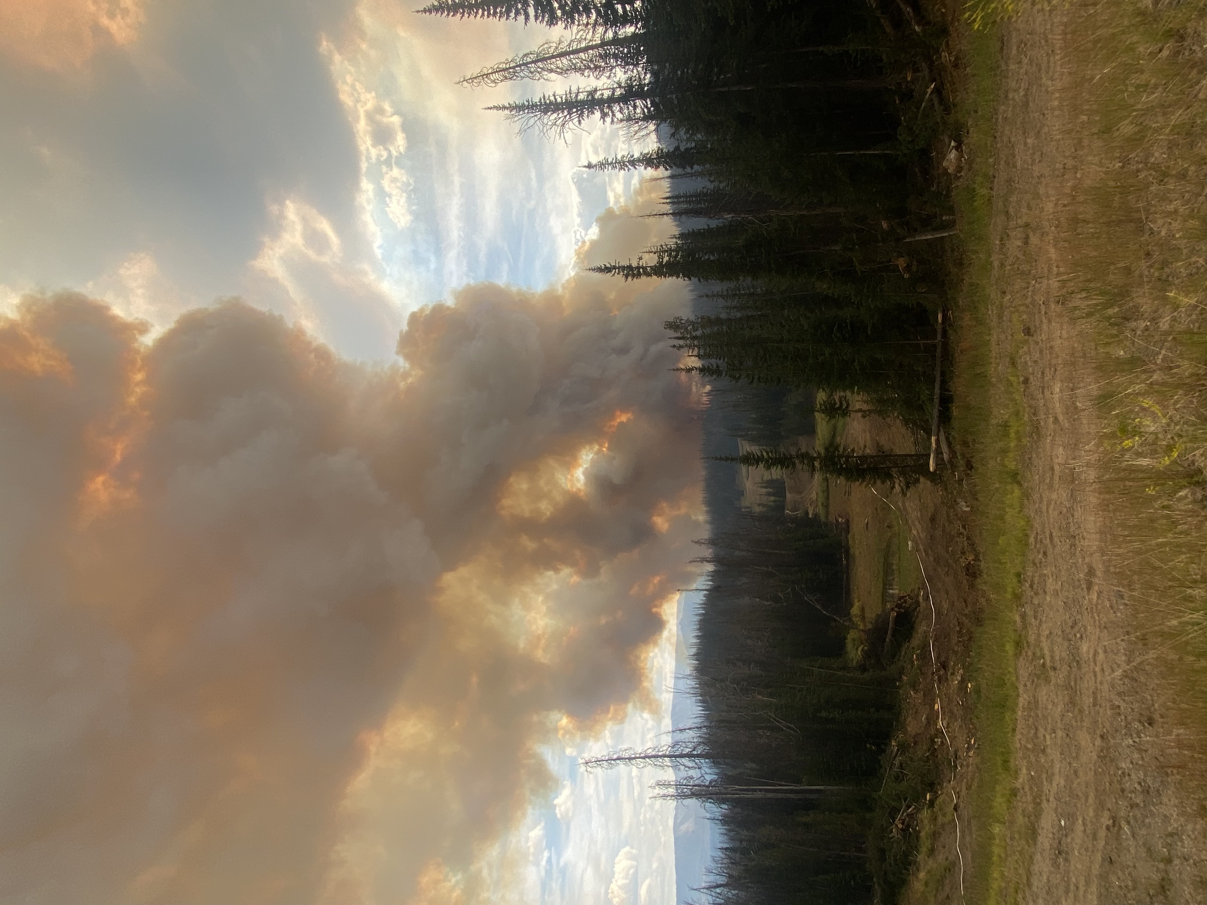
Middle Fork Complex Fire Update for Tuesday 09 03 2024
Related Incident:
Publication Type: News
Fire Size: 56,806 Acres
Completion:14%
Resources: 919
Weather and Fire Behavior:
There is a 20 - 30% chance of showers in the morning, with unstable conditions throughout the afternoon. A front will pass through around 6:00 p.m., causing winds to switch to the northwest. Temperatures will be cooler with increasing humidity. Fire behavior is expected to remain moderated, with a chance of increased fire behavior due to winds arriving with the cold front.
Operations:
Crews continue to add black line along the western edge of the Bulldog Fire, and hope to have continuous containment on this side in the near future. Work continues on the indirect containment line that crews are building towards the Rattlesnake trail system. Firefighters will focus on road improvements and handline in the Silver Creek area today.
Mop up continues on the west side of the Nellie fire, while the Highway 17 corridor remains quiet, with patrols continuing throughout the day. Road improvements and the removal of dead trees, hazardous trees, also referred to as snags, are the focus on Forest Road 555.
Crews will focus on mop up operations on the southwest side of the Deadwood Reservoir. On the east side of the reservoir, firefighters are working to prevent the fire from moving further north. A direct line is being constructed from the reservoir to Wilson Creek. Firefighters will begin mop up operations today between the reservoir and the Bearskin fire scar. Military crews are removing brush and limbing trees along roads on the north side of the reservoir.
Today, firefighters will work to protect the White Hawk Mountain Lookout and Scott Mountain Lookout. They will start to make preparations to keep these lookouts safe.
Four helicopters remain on the fire with plans to start flight operations after 10:00 am this morning, if conditions allow.
Closures:
The Boise National Forest has issued Order Number 0402-06-60, effective August 23, 2024. Highway 21 is closed from the Sourdough Lodge in Lowman to Stanley (MP 84 to 130) due to wildfire activity. Only local traffic is permitted between the Sourdough Lodge and Warm Springs Airstrip. For additional information, visit https://511.idaho.gov/
Temporary Flight Restrictions (TFR):
A TFR is in effect over the fire area. It is illegal for the public to fly drones over or near wildfires due to the risk of accidents and interference with firefighting efforts.
Sharrott Creek Fire Daily Update 09 03 2024
Related Incident:
Publication Type: News
Northern Rockies Team 3, Incident Commander Mike Behrens
Location: Three miles west of Stevensville, Montana in Ravalli County
Start Date: 8/23/2024
Cause: Lightning
Size: 2,399 Acres
Completion/Containment: 3 percent
Resources assigned: 626 people
No infrared flight was available overnight due to smoke coverage, therefore acreage was not updated.
Current Status
Fire established in the head of Larson Creek on the northern boundary. Firefighters worked to hold and secure existing control lines during the passing cold front. Water dropped from the heavy helicopters helped crews catch a spot fire and cooled the fire edge. Additional resources are assigned today to continue holding and securing lines.
On the east side, crews dug hand line around a spot on the northeast corner yesterday, assisted by water from air resources. They will continue cleaning and mopping up the burnout on the dozer line along the Forest boundary.
On the south edge, the fire spotted onto the north slopes in upper McCalla Creek yesterday. Firefighters and helicopters worked most of the evening to curb fire progression. Crews on the night shift worked hard to hold the fire in its current footprint. Further south, more dozer line was completed and today firefighters will continue to construct and improve direct and indirect control lines using heavy equipment and hand crews. Yesterday crews connected existing roads together with dozer and hand lines to create a secondary control line south of the fire. Firing may occur as conditions allow today, as resources will work take advantage of cooler weather and build direct line.
Significant fire growth occurred on the west side of the fire with strong winds from the passing cold front.
Structure protection resources are staging in nearby neighborhoods during the day to respond to fire activity. Night shift resources will work on the southern, eastern and northern edges and patrol affected neighborhoods. They also have initial attack responsibilities. Aviation resources will check fire spread and support firefighters as smoke allows.
Weather and Fire Behavior
The fire experienced a trace of rain overnight. Temperatures will be in the mid-70s over the fire. Intermittent thunderstorms are expected with the chance of wetting rain and stronger outflow winds. Winds are expected to be generally west at 16 mph. Decreased fire behavior is expected.
SMOKE
For the current smoke reports, visit https://www.airnow.gov/
EVACUATIONS, RESTRICTIONS, CLOSURES
The Ravalli County Sheriff’s Office has updated evacuation orders and warnings for neighborhoods in the vicinity of the Sharrott Creek Fire. Download the Ravalli Co. Sheriff’s Office app for information. Evacuation questions can be directed to the Ravalli County Emergency Operations Center at 406-375-6650. The Bitterroot National Forest has issued an area closure from North Fork Sweeney Creek to Sweathouse Creek. See https://tinyurl.com/Sharrottclosure for the order and map. There are temporary flight restrictions (TFR) over the fire area west of Highway 93 from Bass Creek to Big Creek.
Settings - change map background and toggle additional layers
Filter - control incident types displayed on map.
Zoom to your location
Reset map zoom and position
Could not determine your location.
Show Legend
 Wildfire
 Prescribed Fire
 Burned Area
Response
Burned Area
Response Other
Other
Bear Fire, Tahoe National Forest
Unit Information
Incident Contacts
Limepoint Fire Daily Update September 3 2024 09 03 2024
Related Incident: Limepoint Fire
Publication Type: News
Limepoint Fire
Tuesday, September 3, 2024
Contacts for Fire Information:
208-992-3032 or 2024.limepoint@firenet.gov
https://inciweb.wildfire.gov/incident-information/idpaf-limepoint-fire
https://www.facebook.com/payettenationalforest/
Despite yesterday’s weather, the Limepoint Fire did not add any acreage overnight and containment remains the same at 93%. The increased winds and storm fronts have brought clearer skies but greater potential for new large fire growth. Crews on the Limepoint are staying vigilant to keep the fire within its containment lines through the turbulent weather.
Intermittent showers and thunderstorms are expected today until about 3:00 p.m. Winds near the storms could be gusty and erratic, but the potential for high winds decreases throughout the day as the chance for wetting rain increases. Tomorrow will see a return to the hot and dry weather we saw last week as a strong high-pressure ridge settles in. With the dry conditions and light wind, there may be more smoke in the area.
The Limepoint Fire threatened nearly 100 structures, but fortunately none were damaged or destroyed. Moving forward, if you would like to make your property more fire-adapted and help firefighters safely protect it, think about creating defensible space. Defensible Space is the separation of structures and property access from wildland fuels. For those that live in the wildland-urban interface (WUI), please use these guidelines to make your home fire safe.
Zone 0 (0-5 ft): Ember-Resistant Zone – This zone should be devoid of vegetation and debris with hardscape or gravel. Be sure to keep this zone clean of any woodpiles or wood mulch.
Zone 1 (5-30 ft): Lean, Clean and Green – All dead vegetation should be removed, and shrubs and trees should be spaced apart. Trees should have all ladder fuels removed, and vegetation should be watered if possible.
Zone 2 (30-100 ft): Reduced Fuel Zone – Should reduce fire spread by spacing trees and shrubs, limbing lower branches, and keeping outbuildings and propane tanks clear from fuels.
For more information, please visit: https://www.livingwithfire.org/
Evacuations: Cuprum remains at a Level 1 (READY) evacuation level.
Closures: The Forest Closure Order updated Monday, August 26, 2024, at 7:00 a.m. Some areas previously closed to the public have been reopened. For details about the closure, visit https://www.fs.usda.gov/alerts/payette/alerts-notices. There is still a lot of work being done in the fire area; for your safety and the safety of firefighters, please observe the existing Payette Forest Closures still in effect and watch out for firefighters and fire traffic.
Restrictions: Effective 12:01 a.m. on Friday, August 30, 2024, Stage 1 fire restrictions were lifted. There are currently no fire restrictions in place, but visitors are reminded that vegetation is still dry and to be careful with all use of fire outdoors.
House Draw Fire Daily Update for September 3 2024 09 03 2024
Related Incident: House Draw Fire
Publication Type: News
Hot, dry conditions continue as crews make steady progress on suppression repair
Daily Update September 3, 2024
Fire Information Phone: 307-201-3885 (8 a.m. – 8 p.m.)
Media Information Phone: 307-543-7202 (8 a.m. – 8 p.m.)
Suppression Repair Phone: 307-303-7642 (8 a.m. – 8 p.m.) This phone line is for private landowners to contact fire officials with repair of heavy equipment line or cut fence that occurred during suppression efforts. Please be aware that this phone line will be unstaffed starting Wednesday, September 4, 2024, at 8:00 p.m.
Email: 2024.housedraw@firenet.gov
Acres: Flat Rock – 52,421; Remington – 196,368; Constitution – 24,630; House Draw – 174,547; Silver Spoon – 1,721
Acreage changes may occur due to overnight operations and infrared mapping.
Containment: Flat Rock – 78% Remington – 86%; Constitution – 95%; House Draw – 94%; Silver Spoon – 0%
Location: Flat Rock – 11 miles northwest of Gillette, WY; Remington – 14 miles northeast of Leiter WY, multiple counties in southeast MT; Constitution – 11 miles northeast of Gillette, WY; House Draw – 9 miles southeast of Buffalo, WY; Silver Spoon – 37 miles north of Gillette, WY
Start Date: August 21, 2024 Personnel: 547 Fuels: Grass, brush and timber
Resources: 10 crews | 57 engines | 14 water tenders | Heavy Equipment
Highlights: Thanks to the hard work of firefighters, crews and heavy equipment on the Flat Rock, Remington, Constitution, House Draw and Silver Spoon fires, approximately 212 miles of fireline has been repaired to date.
Fire Activity: The fire area will experience hot, dry conditions again today, increasing the potential for new starts. Additionally, smoke may be visible as unburned fuels within the interior of containment lines ignite, primarily in cottonwood stands, juniper drainages and pockets of pines.
Silver Spoon – Firefighters on the Silver Spoon Fire patrolled the area yesterday, September 2, to identify heat sources after conducting burn operations on Sunday night. Today, crews will scout critical holding points, secure the perimeter and begin mop-up.
Flat Rock – Heavy equipment repaired line from the north end of the Flat Rock Fire, south along the perimeter. Additional resources worked from the eastern perimeter, into the interior of the fire, also moving south. Today, crews will continue suppression repair activities including fence repair, where needed.
Remington – Crews worked to secure containment lines and mop-up hot spots on the Remington Fire yesterday while heavy equipment conducted suppression repair. Heavy equipment operators repaired fireline on the Wyoming side of the fire as well as along the southwestern perimeter. Bulldozers worked along the northwest portion of the fire, below Birney, MT, and hand crews secured line where needed. Today, heavy equipment and crews will build on the yesterday’s efforts, building water bars on the east portion of the fire near Poker Jim and moving into their interior.
Constitution – Yesterday, graders worked north to south on the Constitution Fire. Today, hotshots and a hand crew will continue securing line on the eastern and northern edges of the fire area.
House Draw – Hand crews worked on the south end of the House Draw Fire yesterday while heavy equipment made progress along the I-90 corridor. Today, crews will continue suppression repair work as graders and other heavy equipment move to the north side of the interstate.
Evacuations: An evacuation order is in effect for Bitter Creek Road area in northern Campbell County due to the Silver Spoon Fire. Additional information available at www.campbellcountywy.gov/AlertCenter.aspx?AID=Evacuation-For-the-Bitter-Creek-Road-Are-98.
Weather: Record breaking temperatures were recorded in Sheridan (101 degrees) and Gillette (99 degrees) yesterday. A Red Flag warning is in effect today. The fire area will also see scattered thunderstorms with limited precipitation and gusty outflow winds. Temperatures will remain in the low 90s.
Fire Restrictions and Closures: Fire Restrictions are in place across the fire area including:
- The Custer Gallatin National Forest (Powder River and Rosebud Counties, Montana) implemented road closures within the Remington Fire burned area located on National Forest System lands, effective August 30, 2024. More information available at https://www.fs.usda.gov/Internet/FSE_DOCUMENTS/fseprd1202405.pdf.
- Stage 1 Fire Restrictions for Custer Gallatin National Forest, Ashland Ranger District (effective August 1, 2024). More information available at https://www.fs.usda.gov/alerts/custergallatin/alerts-notices/?aid=89447.
- Stage 1 Fire Restrictions for Bureau of Land Management Buffalo Field Office in Johnson County (as of July 1, 2024) and Campbell and Sheridan Counties (as of July 9, 2024). More information available at https://www.blm.gov/programs/public-safety-and-fire/wyoming/fire.
- Stage 1 Fire Restrictions for Sheridan, Campbell and Johnson Counties in Wyoming (as of July 9, 2024). More information available at https://wsfd.wyo.gov/fire-management/fire-restrictions.
- Stage 1 Fire Restrictions for Thunder Basin National Grasslands within the Douglas Ranger District in Converse, Campbell, Crook, Natrona, Niobrara, Platte, and Weston counties in the State of Wyoming (as of August 7, 2024). More information available at https://www.fs.usda.gov/detail/mbr/news-events/?cid=FSEPRD1199001.
- The Medicine Bow-Routt National Forest implemented a temporary closure of the popular Weston Recreation Area on the Thunder Basin National Grasslands within the Constitution Fire (Johnson County, WY), effective August 23, 2024. More information available at https://www.fs.usda.gov/Internet/FSE_DOCUMENTS/fseprd1201513.pdf.
More Information:
InciWeb (House Draw Fire): https://inciweb.wildfire.gov/incident-information/wyhpd-house-draw-fire
InciWeb (Remington Fire): https://inciweb.wildfire.gov/incident-information/mtgnf-remington-fire
Public Information Linktree: https://linktr.ee/housedrawfire
Facebook: https://www.facebook.com/SWIMT5/
Copperfield Fire Evening Update for 922024 09 03 2024
Related Incident: Copperfield Fire
Publication Type: News
Copperfield Fire Evening Update for Monday, September 2nd - 8PM
Monday, September 2nd was a day of transition on the Copperfield Fire. Oregon Department of Forestry’s Incident Management Team 3 and Oregon State Fire Marshal Red Incident Management team are currently managing the fire under unified command as of 6 pm this evening. The fire grew to an estimated 3,241 acres, driven by strong afternoon winds. Fire growth, which occurred mainly on the western flank of the fire, resulted in new spot fires up to half a mile.
Fire crews worked with heavy equipment operators to put in and solidify dozer line on the east and north end of the fire. As those lines were solidified throughout the day, they continued to hold in part due to fuels treatments completed along the east flank of the current fire footprint, and crews have been mopping up to extinguish hot spots. On the west flank of the fire, fire crews were challenged by changing wind direction and active fire behavior.
Firefighters from across the state continue to arrive to battle the blaze and were supported by a half dozen aircraft. The focus for tonight’s night operations is to take advantage of low temperatures and high humidity to solidify the containment lines established today. Crews are focused on preserving life and property and keeping the current fire footprint as small as possible to minimize impacts to timber, rangeland, and cultural sites.
Residents and visitors in the area are advised to stay safe and stay informed. Visit https://www.klamathcounty.org/300/Emergency-Management for up-to-date information on evacuations and evacuee resources. A road closure remains in effect on the Sprague River Highway between mile markers 5 and 15. More information will continue to be posted and shared to this Facebook page.
Per the Klamath County Sheriff's Office, evacuation levels will be reassessed the morning of September 3rd. Any changes will be published first to Genasys Protect, then by Mass Notification, then to the Klamath County Common Operating Picture (COP) - https://www.klamathcounty.org/300/Emergency-Management
A road closure remains in effect on the Sprague River Highway between mile markers 5 and 15.
Settings - change map background and toggle additional layers
Filter - control incident types displayed on map.
Zoom to your location
Reset map zoom and position
Could not determine your location.
Show Legend
- Wildfire
- Prescribed Fire
- Burned Area
Response
- Other
Copperfield Fire
Unit Information
Incident Contacts
US26287 Closed to Public Travel due to Fish Creek Fire 09 02 2024
Related Incident:
Publication Type: Announcement
The Wyoming Department of Transportation will close US26/287 west of Dubois about 4 pm today due to excessive smoke and limited visibility near the Fish Creek Fire on Togwotee Pass.
As of this morning, more than 15,500 acres had burned on the Fish Creek Fire. The fire has been very active today and continues to burn in a northeast direction. Hot winds, low humidity and higher-than-normal temperatures are helping the fire to advance near to US26/287 (Togwotee Pass).
The duration of the highway closure is not known at this time. If you’re able, make alternative travel plans. For road conditions, please go to wyoroad.info.
Wyoming Travel Information Map (wyoroad.info)
or
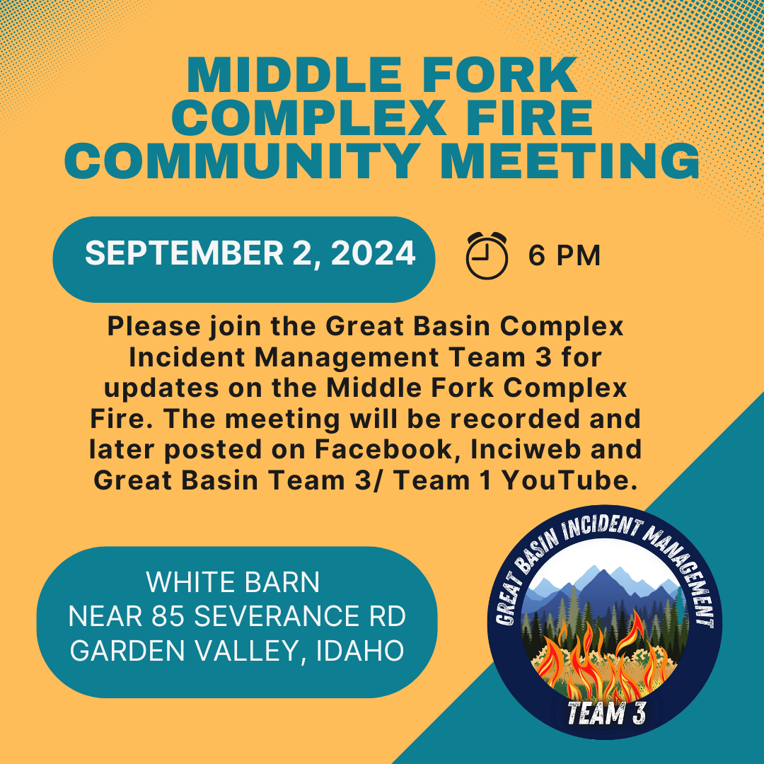
Middle Fork Complex Community Meeting Today 09 02 2024
Related Incident:
Publication Type: Announcement
Please join the Great Basin Complex Incident Management Team 3 today at 6 pm at the white barn building near 85 Severance Road, Garden Valley, Idaho for updates on the Middle Fork Complex Fire. The meeting will be recorded and later posted on Facebook and Great Basin Team 3/ Team 1 YouTube.