
Ruby Fire Update Monday September 2 2024 09 02 2024
Related Incident: Ruby Fire
Publication Type: News
Ruby Fire Quick Facts
Size: 959 acres Location: North Cascades National Park, Ruby Mountain, Diablo, Washington
Containment: 0% Cause: Lightning/Natural
Start Date: August 9, 2024 Total Personnel: 50
Fire Information:
Inciweb: https://inciweb.wildfire.gov/incident-information/wancp-ruby-fire Email: 2024.Ruby@firenet.gov
Facebook: https://www.facebook.com/people/Ruby Fire/61563760546137
Phone: 1-360-208-8096
Current Status: The Ruby Fire produced more smoke yesterday than in recent days due to an increase in fire activity as a result of above average temperatures and lower relative humidity. Firefighters continue to implement structure protection plans on several key values at risk, while fire managers continue to monitor fire activity utilizing aircraft equipped with infrared. Cooler temperatures are expected earlier in the week, but are expected to climb to above average temperatures by Thursday.
Planned Actions: Firefighters will continue to protect critical infrastructure, park campgrounds, trails, backcountry camps and other resources in preparation for possible fire growth. The Ruby Fire is a full suppression fire, and firefighters are utilizing strategies and tactics that provide the highest likelihood for success, while mitigating risks to firefighters and the public. The main objectives are protecting human life, minimizing damage to values at risk and limiting wildfire spread to the north and west.
Weather: A return to onshore flow will bring cooler and more moist air to the fire site on Monday. Additionally, there is a low (10-20%) chance for a few isolated thunderstorms near the fire site Monday afternoon and evening. Any storms that develop should be short-lived and contain limited rainfall, but the strongest storms could produce gusty winds, small hail, and lightning. Conditions remain cool on Tuesday before warming and drying back up into mid-week. Thursday currently looks to be the warmest and driest day of the week, through temperatures look to remain above average through the weekend.
Closures: There are multiple closures in place for public safety; Colonial Creek South Campground and boat launch, Thunder Arm south of Diablo Lake. For a full list of closures visit https://go.nps.gov/fireclosures
Smoke: Air quality is forecast to be GOOD on Monday and Tuesday https://www.airnow.gov/
Burning Restrictions: Campfires, the ignition of wood, briquettes, or any fuel in fire pits, fire pans and barbeque grills, are banned in all portions of North Cascades National Park Service Complex: North Cascades National Park, Ross Lake National Recreation Area and Lake Chelan National Recreation Area.
Drone Restrictions: Drones can seriously impact the safety of firefighting efforts, and operating drones within North Cascades National Park is prohibited, except with prior written approval from the superintendent.
Cooperating Agencies & Tribes: National Park Service, Upper Skagit Indian Tribe, Seattle City Light, Whatcom County, Whatcom County Sheriff’s Office, Washington State Dept. of Transportation.
If you would like to sign up for our daily updates, please send an email to: 2024.Ruby@firenet.gov
Limepoint Fire Daily Update September 2 2024 09 02 2024
Related Incident: Limepoint Fire
Publication Type: News
Limepoint Fire – RED FLAG WARNING
Monday, September 2, 2024
Contacts for Fire Information:
208-992-3032 or 2024.limepoint@firenet.gov
https://inciweb.wildfire.gov/incident-information/idpaf-limepoint-fire
https://www.facebook.com/payettenationalforest/
A Red Flag Warning has been issued for the Limepoint Fire area for Monday, September 2, 2024, from 9:00 a.m. to midnight.
A system moved in overnight bringing the potential for showers and thunderstorms. The first band of weather is expected between 8:00 a.m. and noon and has a 10% chance of thunderstorms. Winds gusts from the southwest up to 30 mph are possible. There is a 30% chance of a second band of storms in the late afternoon and evening, arriving between 7:00 p.m. and 9:00 p.m. Those storms will have wind gusts that could potentially reach 60 mph. Additional storms are possible overnight Monday night and into Tuesday morning. Tuesday afternoon will have higher relative humidity, lower temperatures, and a southwest wind.
The Limepoint Fire held steady yesterday and did not add any acreage overnight. Containment remains the same at 93%. The smoke that was visible yesterday continues to come from interior fires and especially from other fires in the area.
If you are someone who is sensitive to all the smoke in the air, there are several things you can do to breathe more easily. Stay inside with the doors and windows closed when it is smoky outside and use a high efficiency air filter to capture fine particles in the smoke. You can use a portable air filter to create a “clean room” in your house. If you must go outside, wear an N95 respirator mask and take it easy. And check the Idaho Department of Environmental Quality’s website at https://airqualitymobile.deq.idaho.gov/ or AirNow’s Fire and Smoke Map at https://fire.airnow.gov/ for the latest air quality readings.
Evacuations: Cuprum remains at a Level 1 (READY) evacuation level.
Closures: The Forest Closure Order updated Monday, August 26, 2024, at 7:00 a.m. Some areas previously closed to the public have been reopened. For details about the closure, visit https://www.fs.usda.gov/alerts/payette/alerts-notices. There is still a lot of work being done in the fire area; for your safety and the safety of firefighters, please observe the existing Payette Forest Closures still in effect and watch out for firefighters and fire traffic.
Restrictions: Effective 12:01 a.m. on Friday, August 30, 2024, Stage 1 fire restrictions were lifted. There are currently no fire restrictions in place, but visitors are reminded that vegetation is still dry and to be careful with all use of fire outdoors.
Wapiti Fire Community Meeting 09 03 2024
Related Incident:
Publication Type: Announcement
Wapiti Fire Community Meeting
Tuesday, September 3, 2024, 6 p.m.
Lowman Fire Station, 8000 ID-21, Lowman, Idaho
The Rocky Mountain Complex Incident Team 1 members and local authorities will provide information on the status of the Wapiti Fire. We invite you to join us in person or there will also be a virtual option, if internet service allows. The meeting will be livestreamed, and the recording later posted to the Wapiti Facebook Page. https://facebook.com/wapitifireinfo2024
West Mountain Fires Closures Current Evacuation Information Fire Restrictions TFR Important Links 09 05 2024
Related Incident: Boulder FireDollar Fire
Publication Type: Announcement
FOREST CLOSURES
Boise National Forest:
- Closure Order #0402-04-100 Dollar/Oro Area, Trail, and Road Closure – For Forest closure areas over the Dollar fire. For more information visit: https://www.fs.usda.gov/Internet/FSE_DOCUMENTS/fseprd1199005.pdf
- Closure Order #0402-06-60 Anderson-Bulldog-Nellie Fire Area, Road, and Trail Closure – For Forest closure areas over the Goat and Snag Fires. For more information visit: https://www.fs.usda.gov/Internet/FSE_DOCUMENTS/fseprd1201349.pdf
- Closure Order #0402-04-98 Boulder Fire Area, Trail, and Road Closure – For Forest closure areas around the Boulder Fire. For more information visit: https://www.fs.usda.gov/Internet/FSE_DOCUMENTS/fseprd1197540.pdf
Payette National Forest:
- Closure Order #0412-606 Wolf Creek Burned Area Road and Trail Closure - encompassing National Forest System Trail #560 and NFS Road #1762. For more information visit: https://www.fs.usda.gov/Internet/FSE_DOCUMENTS/fseprd1202093.pdf
- Closure Order #0412-605 Dollar Fire Area and Trail Closure - north of Warm Lake Road, west of South Fork Salmon River, east of NFS Trail #101, and south of NFS Trail #99 and #100. For more information visit: https://www.fs.usda.gov/Internet/FSE_DOCUMENTS/fseprd1201446.pdf
FIRE RESTRICTIONS
The Boise National Forest is in Stage 1 Fire Restrictions. For more information visit: Boise National Forest.
EVACUATION INFORMATION
Valley County Sheriff’s Office is responsible for issuing and enforcing evacuation orders, and for determining the boundaries of the evacuation area. Fire managers advise the sheriff when management action trigger points have been breached.
There are currently READY, SET and GO evacuation orders in place. To stay up to date with the most current information, sign up for emergency alerts, such as evacuation notices by visiting your county’s emergency alert system:
- Valley County: https://www.co.valley.id.us/CompleteEmergencyNotificationandAlerting
- Adams County: https://public.alertsense.com/SignUp/PublicUser.aspx?regionid=1077
Review the READY, SET, GO evacuation procedure for Valley County: https://www.co.valley.id.us/ReadySetGo
ROAD CLOSURES
Warm Lake Highway Closure: Piloted access continues. Warm Lake Rd will be opened for homeowners and contractors only. You will need to be on the approved list for travel. If you have already been approved, you do not need to sign up again. To be added to the approved list please visit:
- Valley County: https://www.co.valley.id.us/EscortRequest
- Or Call: (208) 382-5160
Active fire behavior continues in the area, please drive slowly, be aware of crews working in the area and watch out for debris.
TEMPORARY FLIGHT RESTRICTIONS
Temporary Flight Restrictions (TFR) are in place over the Boulder, Dollar, Snag, and Goat Fires. Yesterday morning, an aircraft entered the restricted zone without authorization, temporarily grounding fire aircraft and hampering firefighting efforts. Such incidents are reported to the Federal Aviation Administration (FAA) for further review. Wildfires are a no-fly zone for unauthorized aircraft, including drones. TFRs are critical for firefighter and aircraft safety. If you fly, we can’t. For more information, visit http://knowbeforeyoufly.org.
West Mountain Fires Daily Update 09 02 2024
Related Incident: Boulder FireDollar Fire
Publication Type: News
September 2, 2024
Fire Information Phone Line: 208-462-0345 (8 a.m. - 8 p.m.) Email: 2024.Boulder.id@firenet.gov
QUICK FACTS
Fire Location Size Containment Assigned Personnel Inciweb link
Boulder 9 miles SW of Cascade 2,421 acres 57% 327 https://tinyurl.com/ycdfv3tv
Snag 11 miles E of Cascade 30,324 acres 3% 425 https://tinyurl.com/4k9dk3mu
Dollar 18 miles NE of Cascade 3,483 acres 0% 124 https://tinyurl.com/bef6r3tz
Goat 11 miles SE of Cascade 2,708 acres 0% 127 https://tinyurl.com/2h4a3dvr
Cause: Lightning (All Fires) Total Incident Personnel: 1,003
Weather | Anticipated Fire Behavior:
As predicted, yesterday’s hot, dry, and windy weather caused a significant increase in fire behavior, with notable growth on the Boulder, Goat, and Snag fires. Today, a red flag warning is in effect from 9 am to midnight. Two rounds of thunderstorms are expected to pass through the fire area this morning and again this evening, bringing copious lightning and outflow winds up to 45 miles per hour. Little rain is expected. High temperatures and relative humidity are expected to moderate slightly with the arrival of storm events. Active to extreme fire behavior is expected today. Crews are prepared to respond to increased fire activity on the West Mountain fires, as well as to attack and extinguish new lightning-caused ignitions.
- Army crews from the 14th Brigade Engineer Battalion based at Joint Base Lewis McChord are currently assisting with suppression efforts on the West Mountain Fires as well as assisting with adjacent wildfires in the area.
Boulder Fire: Go evacuations are in effect on Cabarton Road on the west side from the Cabarton Bridge to the intersection with West Mountain and on West Mountain Road from Cabarton north to French Creek.
- Under hot, dry, breezy conditions, the Boulder Fire spotted north of Forest Road 446. Most of this fire growth occurred in the Hurdy and Olson drainages. Boulder Fire is our top priority due to proximity to residential areas.
- Type 1 helicopters and water scoopers were utilized to drop water to suppress fire and slow the fire’s progression.
- Firefighters have been moved from the Dollar Fire to assist with suppression efforts on the Boulder Fire.
Dollar Fire:
- Four Army crews supported firefighting efforts on the Dollar Fire yesterday.
- Firefighters are securing and mopping up heat that could threaten the containment line, focusing on the southwestern edge. Some growth occurred at the fire’s north end, near Squaretop Mountain and Squaretop Lake, where rocky terrain and scattered fuels are not conducive to carrying fire.
Snag Fire:
- There was active fire behavior and spotting along the fire’s northern edge at Warm Lake Road, along the eastern edge in Tyndall Creek, and along the southern edge south of Forest Road 409 yesterday.
- At the north end, spot fires spread north across the Warm Lake Road. Crews were able to hem them in with hand line, and they stand ready to attack additional spot fires in that area tomorrow.
- To the east of Snag Fire, masticators are being used to turn brush and regenerating trees between the fire and the Warm Lake area. Dozers are ready to construct contingency lines in this area quickly if they become necessary.
- Along the fire’s southern edge, fire spotted south across Forest Road 409 in terrain not accessible by firefighters.
- Firefighters, with two Army crews, continue to secure and mop up along the western flank to ensure fire does not escape containment.
Goat Fire:
- The southern edge of the Goat Fire showed active fire behavior yesterday, growing toward the south.
- Crews stand ready to defensively burn out fuels along the east side of Forest Service Trail 099 to stall the fire’s advance if it approaches the trail at the top of the ridge.
House Draw Fire Daily Update for September 2 2024 09 02 2024
Related Incident: House Draw Fire
Publication Type: News
Firefighters respond to new start, "Silver Spoon”
Daily Update September 2, 2024
Fire Information Phone: 307-201-3885 (8 a.m. – 8 p.m.)
Media Information Phone: 307-543-7202 (8 a.m. – 8 p.m.)
Suppression Repair Phone: 307-303-7642 (8 a.m. – 8 p.m.) This phone line is for private landowners to contact fire officials with repair of heavy equipment line or cut fence that occurred during suppression efforts.
Email: 2024.housedraw@firenet.gov
Acres: Flat Rock – 52,421; Remington – 196,368; Constitution – 24,594; House Draw – 174,547
Acreage changes may occur due to overnight operations and infrared mapping.
Containment: Flat Rock – 78% Remington – 81%; Constitution – 95%; House Draw – 94%
Location: Flat Rock – 11 miles northwest of Gillette, WY; Remington – 14 miles northeast of Leiter WY, multiple counties in southeast MT; Constitution – 11 miles northeast of Gillette, WY; House Draw – 9 miles southeast of Buffalo, WY
Start Date: August 21, 2024 Personnel: 419 Fuels: Grass, brush and timber
Resources: 5 crews | 49 engines | 10 water tenders | Heavy Equipment
Highlights: The Silver Spoon Fire is a new start within the fire area, first identified yesterday, September 1, 2024. Southwest Area Incident Management Team (SWIMT) 5 will assume command at 6 p.m. today, September 2, 2024.
Fire Activity: Hotter and drier conditions continue today, supporting fire activity across the region. Smoke from the Silver Spoon Fire and interior pockets of fuels may be visible.
Silver Spoon – Ground and air resources engaged in initial attack yesterday with local resources and two hotshot crews from the Constitution Fire. Today, fire resources will continue in extended attack and SWIMT 5 will assume command of the fire at 6 p.m. Aircraft resources remain available to assist in fire suppression needs.
Flat Rock – Suppression repair crews continue to make progress, working north to south on the Flat Rock Fire. Today, heavy equipment will continue repairing fireline as crews scout additional repair needs.
Remington – Activity on the Remington Fire was limited to smoldering and creeping in the northern portion of the fire yesterday. Today, heavy equipment and hand crews will continue line repair across the fire area.
Constitution – Firefighters on the Constitution Fire mopped up remaining heat sources within pine stringers yesterday. Today, crews will patrol and secure line, scouting for heat sources on the eastern edge as heavy equipment operators repair line on the north and northwestern portions of the fire.
House Draw – Minimal heat sources remain on the House Draw Fire. Today, heavy equipment will work to complete repairs on the south side of I-90. Bulldozers and graders will also move north of the interstate, conducting repair needs where identified.
Evacuations: An evacuation order is in effect for Bitter Creek Road area in northern Campbell County due to the Silver Spoon Fire. Additional information available at www.campbellcountywy.gov/AlertCenter.aspx?AID=Evacuation-For-the-Bitter-Creek-Road-Are-98.
Weather: Temperatures continue to rise today with high in the upper-90s and relative humidity dropping into single digits.
Fire Restrictions and Closures: Fire Restrictions are in place across the fire area including:
- The Custer Gallatin National Forest (Powder River and Rosebud Counties, Montana) implemented road closures within the Remington Fire burned area located on National Forest System lands, effective August 30, 2024. More information available at https://www.fs.usda.gov/Internet/FSE_DOCUMENTS/fseprd1202405.pdf.
- Stage 1 Fire Restrictions for Custer Gallatin National Forest, Ashland Ranger District (effective August 1, 2024). More information available at https://www.fs.usda.gov/alerts/custergallatin/alerts-notices/?aid=89447.
- Stage 1 Fire Restrictions for Bureau of Land Management Buffalo Field Office in Johnson County (as of July 1, 2024) and Campbell and Sheridan Counties (as of July 9, 2024). More information available at https://www.blm.gov/programs/public-safety-and-fire/wyoming/fire.
- Stage 1 Fire Restrictions for Sheridan, Campbell and Johnson Counties in Wyoming (as of July 9, 2024). More information available at https://wsfd.wyo.gov/fire-management/fire-restrictions.
- Stage 1 Fire Restrictions for Thunder Basin National Grasslands within the Douglas Ranger District in Converse, Campbell, Crook, Natrona, Niobrara, Platte, and Weston counties in the State of Wyoming (as of August 7, 2024). More information available at https://www.fs.usda.gov/detail/mbr/news-events/?cid=FSEPRD1199001.
- The Medicine Bow-Routt National Forest implemented a temporary closure of the popular Weston Recreation Area on the Thunder Basin National Grasslands within the Constitution Fire (Johnson County, WY), effective August 23, 2024. More information available at https://www.fs.usda.gov/Internet/FSE_DOCUMENTS/fseprd1201513.pdf.
More Information:
InciWeb (House Draw Fire): https://inciweb.wildfire.gov/incident-information/wyhpd-house-draw-fire
InciWeb (Remington Fire): https://inciweb.wildfire.gov/incident-information/mtgnf-remington-fire
Public Information Linktree: https://linktr.ee/housedrawfire
Facebook: https://www.facebook.com/SWIMT5/
Resource Advisor Video 09 01 2024
Related Incident: Park Fire
Publication Type: Announcement
Click on link below to watch Resource Advisor Video
Operations Video 09 01 2024
Related Incident: Park Fire
Publication Type: Announcement
Click link to view the operational video for 9/1/2024
Structure Protection Work on the Middle Fork Complex 09 01 2024
Related Incident:
Publication Type: News
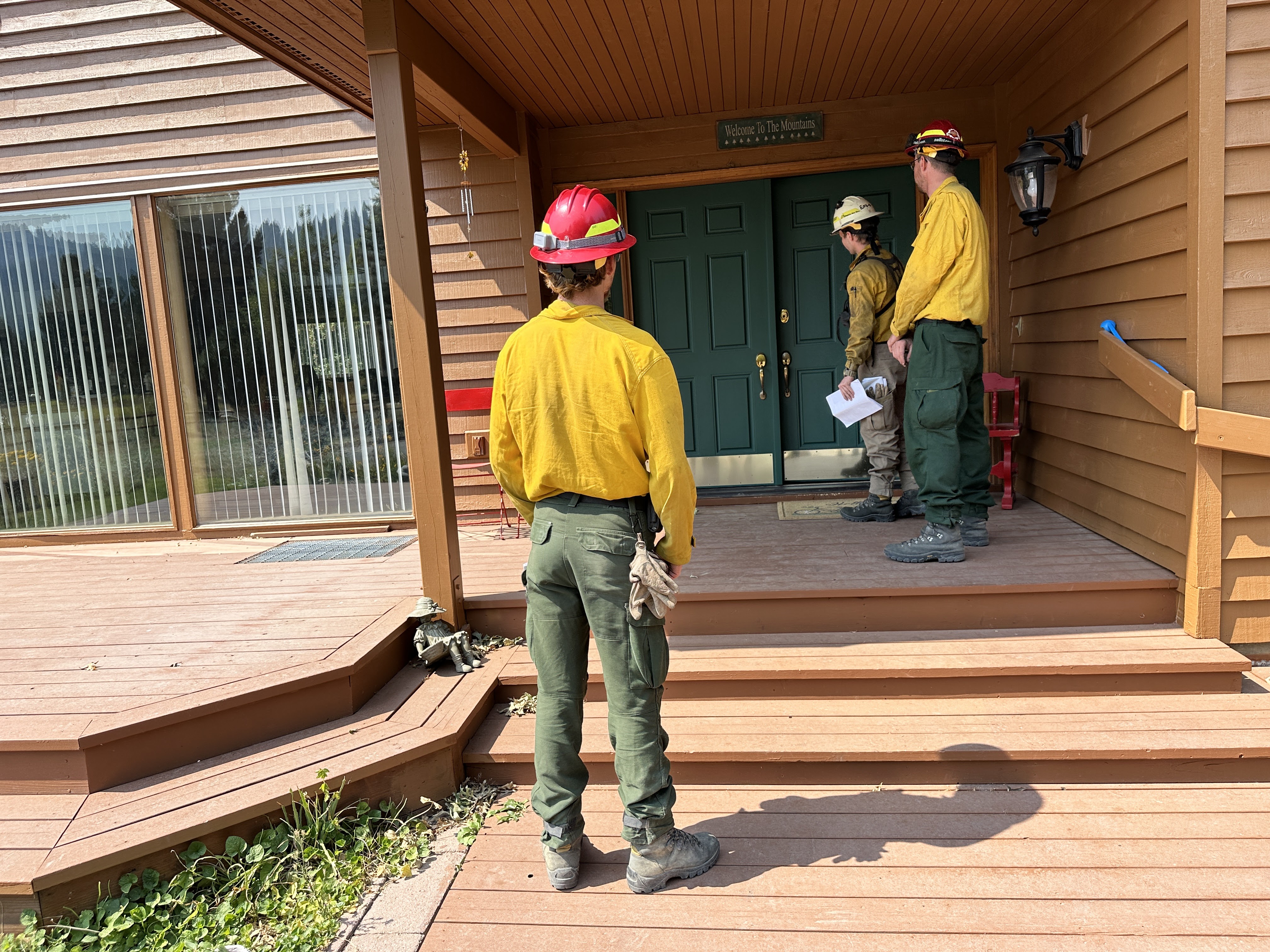
There is a structure protection group assigned to the Middle Fork Complex who's incident command post is in Garden Valley, Idaho on the Boise National Forest. 17 engines and water tenders are tasked with locating, accessing and prepping around structures and identifying mitigation needs for homes in the wildland urban interface throughout the fire. Specifically, these firefighters are responsible for preparing and protecting structures threatened by wildfire.
As more and more people move into and near wildland areas, the risk of wildland fire increases. That area where homes meet the wildlands is called the wildland urban interface or WUI. Fires can start on either private land and move onto forested lands or move from the forested areas to homes. This bi-directional movement creates complexities and difficulties for firefighters. Wildland firefighters are trained to fight wildland fires. Their focus is on protecting the natural resources. They do not carry the appropriate equipment nor are they trained to fight structural fires. Structural firefighters are not trained to fight wildfires nor are they equipped with the specialized equipment wildland firefighters use. Structural firefighters focus on the immediate structure burning. When homes ignite in the WUI, attentions are diverted from the wildlands to saving structures and lives. The role of Federal agencies in the wildland/urban interface includes wildland fire fighting, hazard fuels reduction, cooperative prevention and education and technical assistance. Structural fire protection in the wildland/urban interface is the responsibility of Tribal, State and local governments.
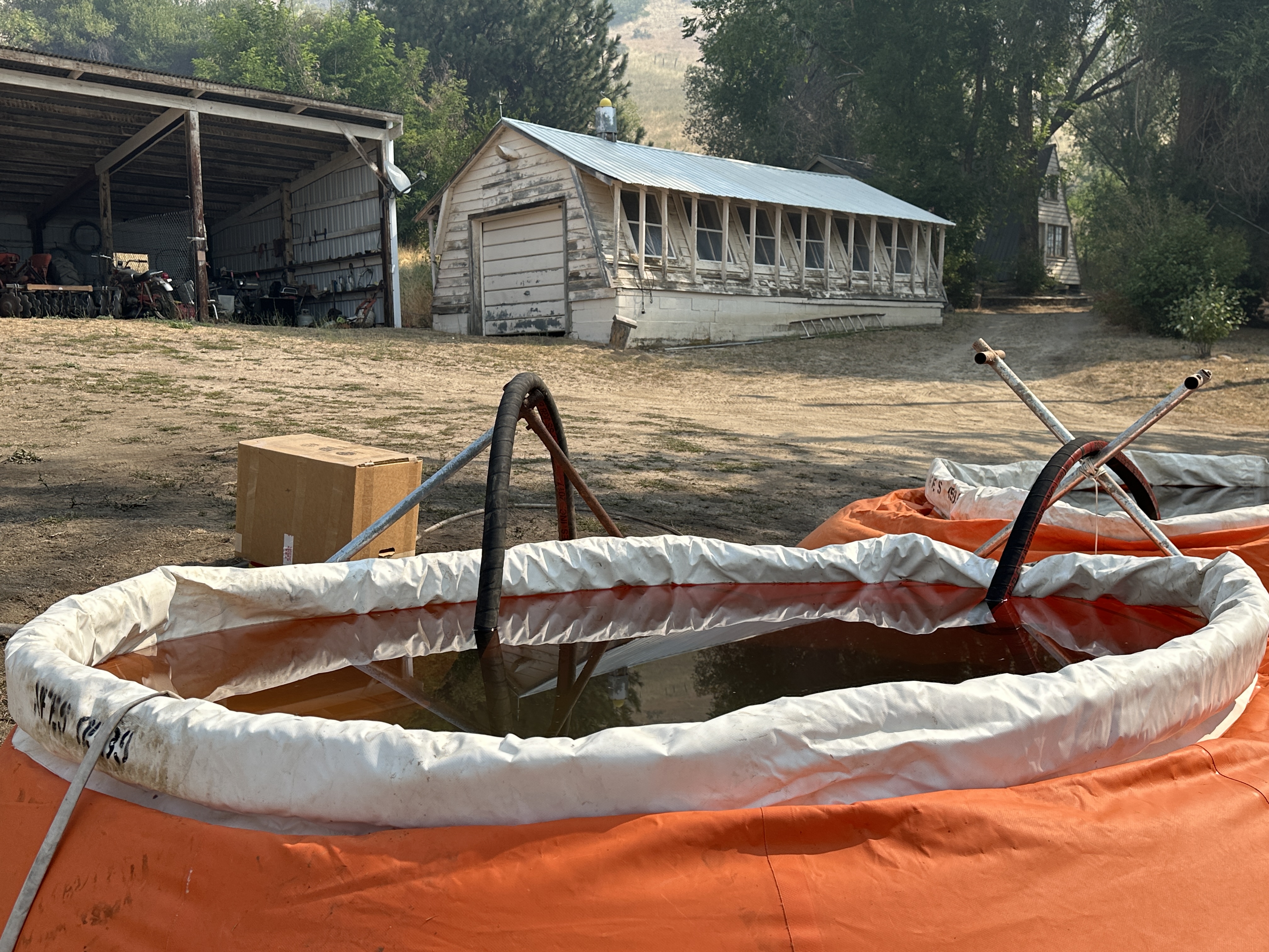
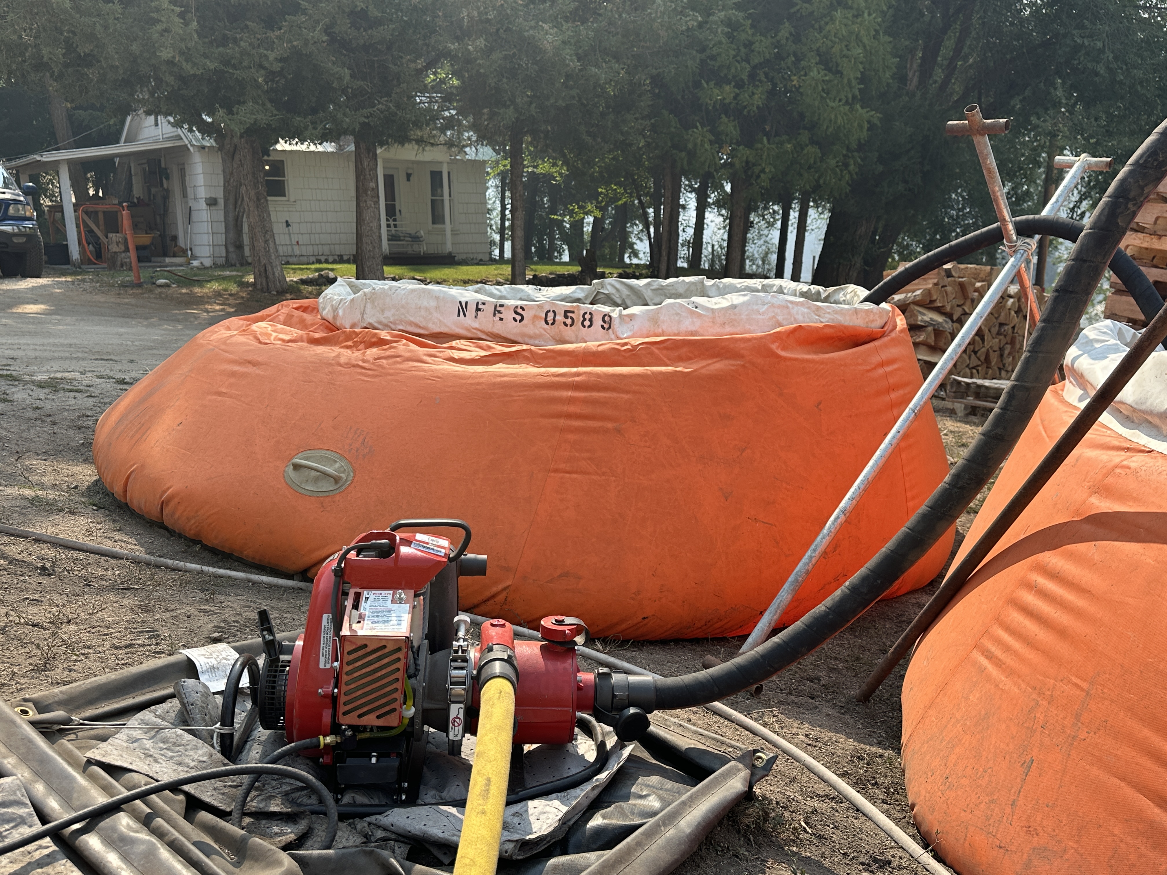
On the Middle Fork Complex, firefighters are meeting with homeowners in their neighborhoods and talking about defensible space and steps they can take before a wildfire approaches an area. Additionally, the structure protection group has placed "pumpkins" or large water storage tanks, and installed pumps and hoses in strategic points around the communities.
There are some things you, as a homeowner, can do to learn to live safely in the fire environment. Although these recommendations are no guarantee from the threat of wildfire, you may make your home and property less susceptible to damage and loss and live more safely. Listed below are some simple precautions.
To Create a Defensible Space:
- Keep annual dry grass and brush removed from a radius of at least 100 feet around structures. Remove dead and dying vegetation.
- Move woodpiles away to a cleared area 30 feet from structures.
- Clear down to dirt 10 feet around propane tanks.
- Remove combustible materials from under decks, stairs and eaves.
- Clear debris (pine needles, leaves) from roof tops and gutters. Clear overhanging limbs 10' from the roof and chimney.
- Provide clear access to your home and make sure your home is clearly marked so that fire service agencies can respond quickly.
- Trim trees from the ground up 6' - 10' and space trees 10' apart.
.JPG?VersionId=xOfIclRUwsqk6RUO8lUoFqb668dvBQqc)
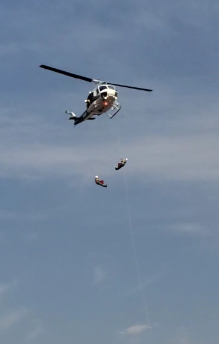
Lucky Peak HeliRappellers 09 01 2024
Related Incident:
Publication Type: News
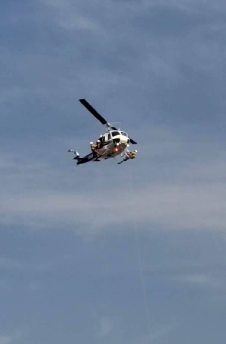
The 15-person Lucky Peak Rappel Crew works with a Type 2 helicopter and is based at Lucky Peak Helibase and Fire Station, just outside of Boise. The Heli-rappellers are trained and equipped for initial attack, manage and support fire and aviation suppression efforts on a local and national level, and perform aviation related projects in support of forest resource needs. This crew is assigned to the Middle Fork Complex Fires which are burning near Garden Valley, Crouch, and Lowman, Idaho.
Firefighters trained in Heli-rappel bring a specialized skillset to the firefighting effort. Heli-rappellers often fight fires in areas with very little access or in situations where it is difficult to have a landing zone to get firefighters in to fight a fire. These are specially trained firefighters rappel from helicopters in order to effectively and quickly respond to fires in remote terrain. Rappellers may land near a wildfire but if there is no landing zone close by, they can utilize their skills to rappel from the hovering helicopter. Once on the ground, crews fight the fires using hand tools, chainsaws, and other firefighting tools.
After fighting a fire, these heli-rappellers must pack all of their ropes, rappel harnesses, flight helmets, and line gear to the closest road or pick up location so they can put their equipment back in service for the next assignment.
To see heli-rappellers in action, click on the photo links below: