
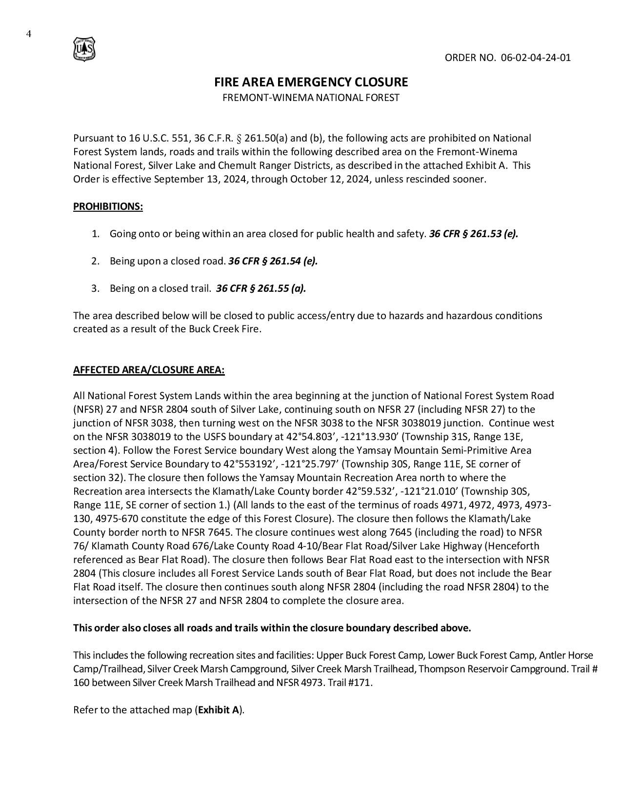
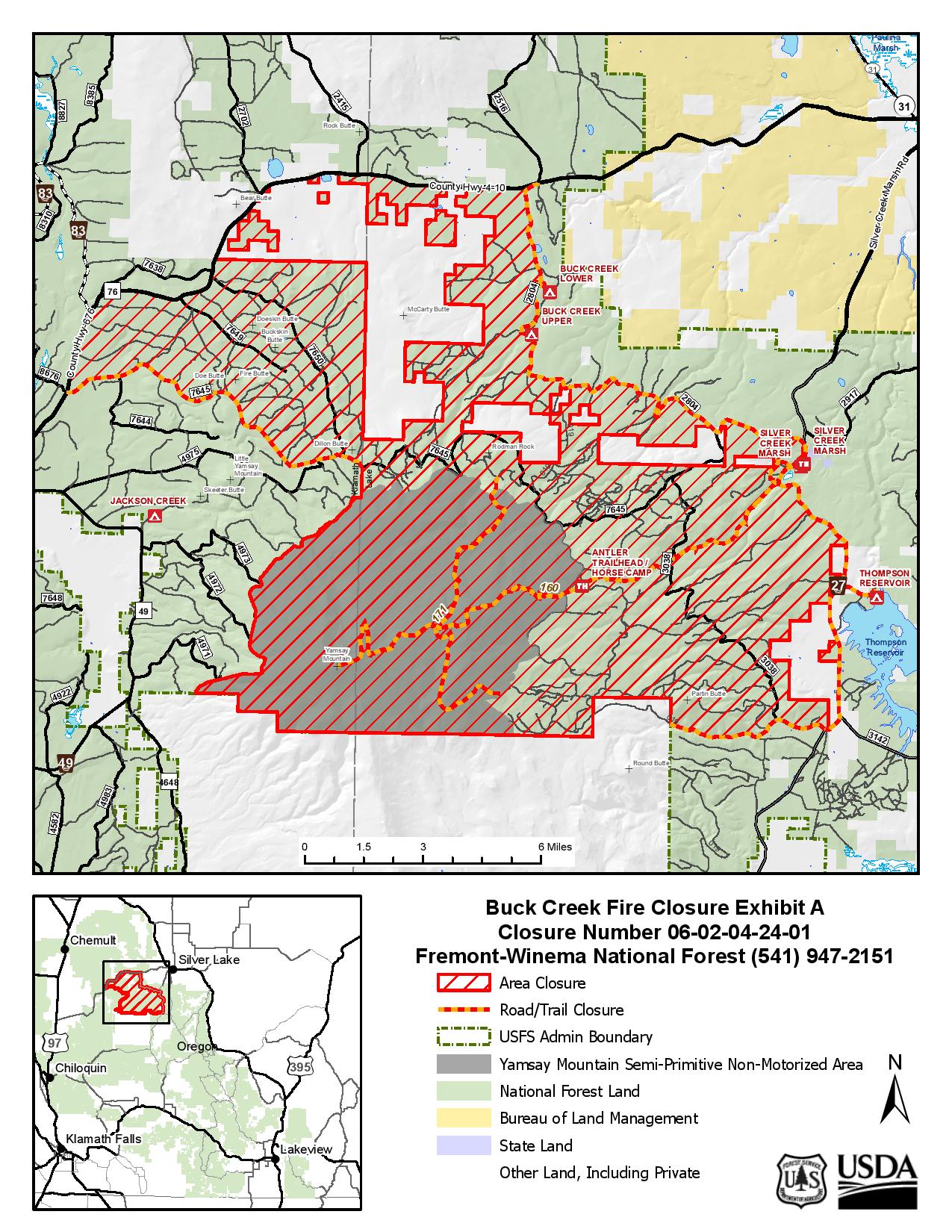
Buck Creek Fire Closures and Restrictions 09 18 2024
Related Incident: Buck Creek Fire
Publication Type: Closures
On September 18,2024, the Lake County Sheriff lifted evacuations for the Buck Creek Fire area, but the forest closure order remains in effect. Public and firefighter safety are the incident’s top priority.
Closures and Restrictions: Current fire danger is high, and restrictions are in place within the Fremont-Winema National Forest. A forest closure order is in effect for the area around the Buck Creek Fire. For the complete order and map as well as more detail on fire restrictions, go to: https://www.fs.usda.gov/fremont-winema.
Buck Creek and Bowman Well Fire Update 09 13 2024
Related Incident: Buck Creek Fire
Publication Type: News
Buck Creek Size: 5,119 acres | Reported Date: September 7 | Cause: Lightning | Containment: 0%
BowmanWell Size: 2,852 acres | Reported Date: September 6 | Cause: Lightning | Containment: 85%
Total Resources Personnel: 629 | Crews: 17 | Engines: 27 | Water Tenders: 11| Heavy Equipment: 10 | Helicopters: 8
(Silver Lake, Ore.) – The Buck Creek Fire started in heavy timber on the Fremont-Winema National Forest about 12 miles southwest of Silver Lake, Ore. in a semi-primitive area of the Forest with limited road access. The Bowman Well Fire is burning in sage brush, grass and juniper on lands administered by the Bureau of Land Management about 3 miles northwest of Christmas Valley, Ore. The Fremont-Winema National Forest has issued a forest closure order around the area of the Buck Creek Fire; public and firefighter safety remain the top priority on these incidents.
Buck Creek: Yesterday, drier conditions resulted in isolated areas of moderate fire activity within the existing fire perimeter. Day and night shift firefighters mopped up hot spots to improve and secure completed dozer line along the north flank and around Rodman Rock in the northwest corner of the fire. Felling crews also dropped snags and other hazardous trees along Forest Road 025 to provide safer conditions for those working along the roads. Dozer line was extended along the eastern fingers and around spots caused by the extreme fire activity on September 10th. On the south edge, some direct dozer line was completed north of Antler Horse Camp. Firefighters scouted for opportunities to connect the new direct fire line with completed line toward the west. Crews used fire hose to mop up hot spots where fire line is completed. Helicopter bucket drops aided firefighters by cooling areas where the fire is actively burning.
Today, crews will improve the portion of the Blue Buck Trail running though the fire area to provide access for medical evacuation and crew support. This will allow firefighters to install and secure direct fire line along the south flank in areas with the highest probability of success. Firefighters will continue to install the direct fire line by hand and with dozers. To support mop-up activities, crews will set up pumps and install hoses along the lines. As the temperature increases and humidity decreases, fire behavior may be most active where winds align with terrain. Aviation resources remain available to assist as visibility allows.
Bowman Well: Some interior fuels flared up yesterday, but there was no threat to established containment lines. Firefighters improved, secured, and patrolled lines and will continue this work today. Some firefighting resources are being shifted to the Buck Creek Fire as containment increases on the Bowman Well Fire.
Evacuations: In coordination with fire managers, the Lake County Sheriff has established evacuations for the Buck Creek Fire. All evacuations for the Bowman Well Fire have been lifted. Go to www.lakecountyor.orgfor details about evacuation levels.
Weather: Maximum temperature in mid 70s and minimum humidity in the 20s are predicted for today and Saturday, with possible rain beginning on Sunday.
Safety: School buses, cattle, firefighting equipment, and crews are present on local roads. Fire managers ask the public to drive attentively and to remain clear of the fire areas. The public also plays an important role in preventing the next wildfire by using caution with all ignition sources. For prevention tips visit, https://keeporegongreen.org. Current fire danger is extreme and restrictions are in place within the Fremont-Winema National Forest. More information can be found at:
https://www.fs.usda.gov/detail/fremont-winema/news-events/?cid=FSEPRD1188568
Closures: A forest closure order is in effect for the area around the Buck Creek Fire. Go to https://www.fs.usda.gov/fremont-winema for the complete order and map. Christmas Valley Airport is temporarily closed to general aviation because it is being used as the helibase for fire operations. A temporary flight restriction remains in place over the Buck Creek Fire.
Smoke: Smoke from multiple fires around the region is affecting the area. For more information on smoke conditions and strategies on limiting exposure, go to: www.oregonsmoke.org or www.AirNow.gov.
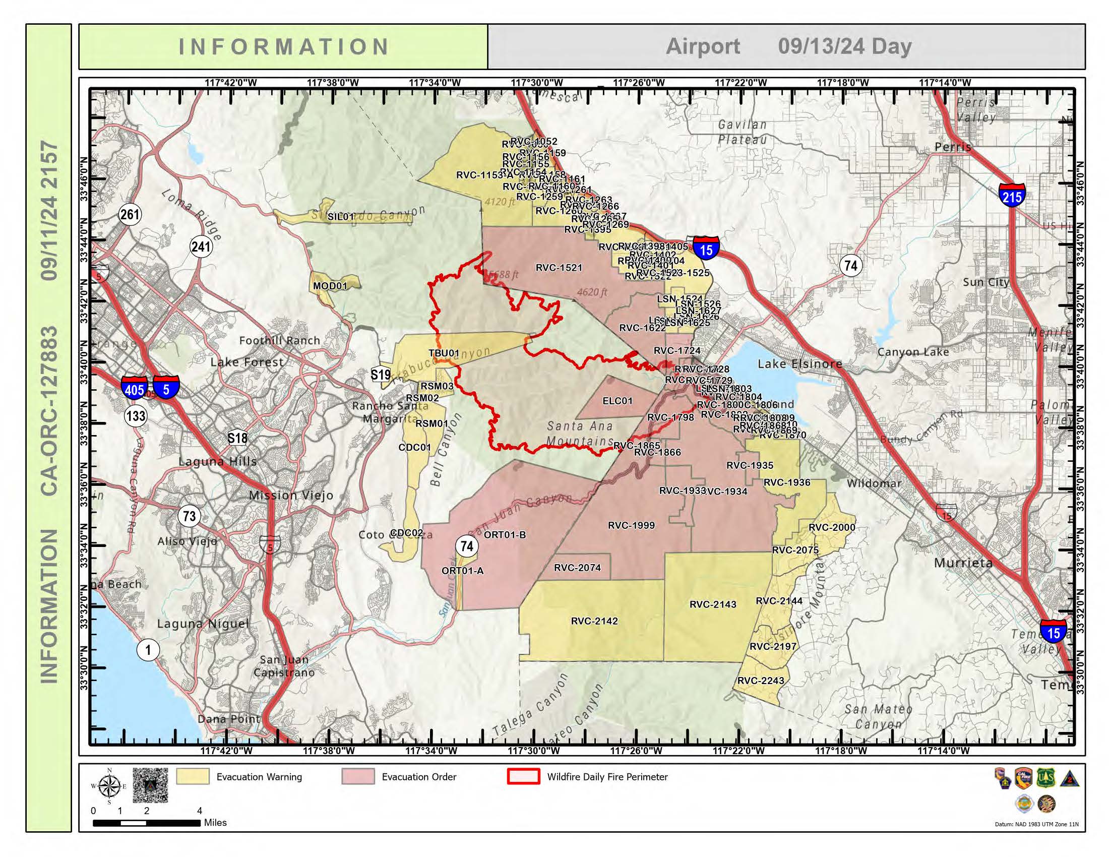
Airport Fire Incident Update 09 13 2024
Related Incident:
Publication Type: News
For a printable version of today's complete update for the Airport Fire, please see the related link below.
Current Situation:
Firefighters on the Airport Fire were able to increase containment to 8%. Experienced hotshot crews are actively constructing fire lines in rugged terrain, employing strategies that minimize risks to personnel. Hand crews are playing a vital role in making progress during favorable weather conditions Aerial support is also instrumental, with aircraft dropping fire retardant to create barriers and slow the fire's spread, ensuring the safety of both firefighters and the public.
On the ground, fire engines are diligently patrolling the fire's perimeter, identifying opportunities for direct attack. In certain areas, such as Lake Elsinore, Decker Canyon Road, and Lakeland Village, firefighters have achieved notable success in increasing containment through mop-up efforts. The fire did slop over near the Harding Truck Trail yesterday and overnight access had been hindered by the challenging terrain; day shift will continue to work direct in that area due to it being safer to engage in the daytime hours.
We are aware that multiple structures have been either damaged or destroyed across the fire. Damage assessment teams are assessing the affected areas to determine the extent. Additional information will be provided as they become available.
Weather conditions are expected to remain favorable for firefighting efforts, with a thickening marine layer, mild temperatures, high humidity, and southwest winds. However, there is a risk of smoke and fog forming in lower drainages in the afternoon, potentially impacting air quality and visibility.
Firefighter’s priorites are to minimize fire impacts by constructing line directly on the fires edge when safe to do so, and to confine the fire to the smallest possible footprint.
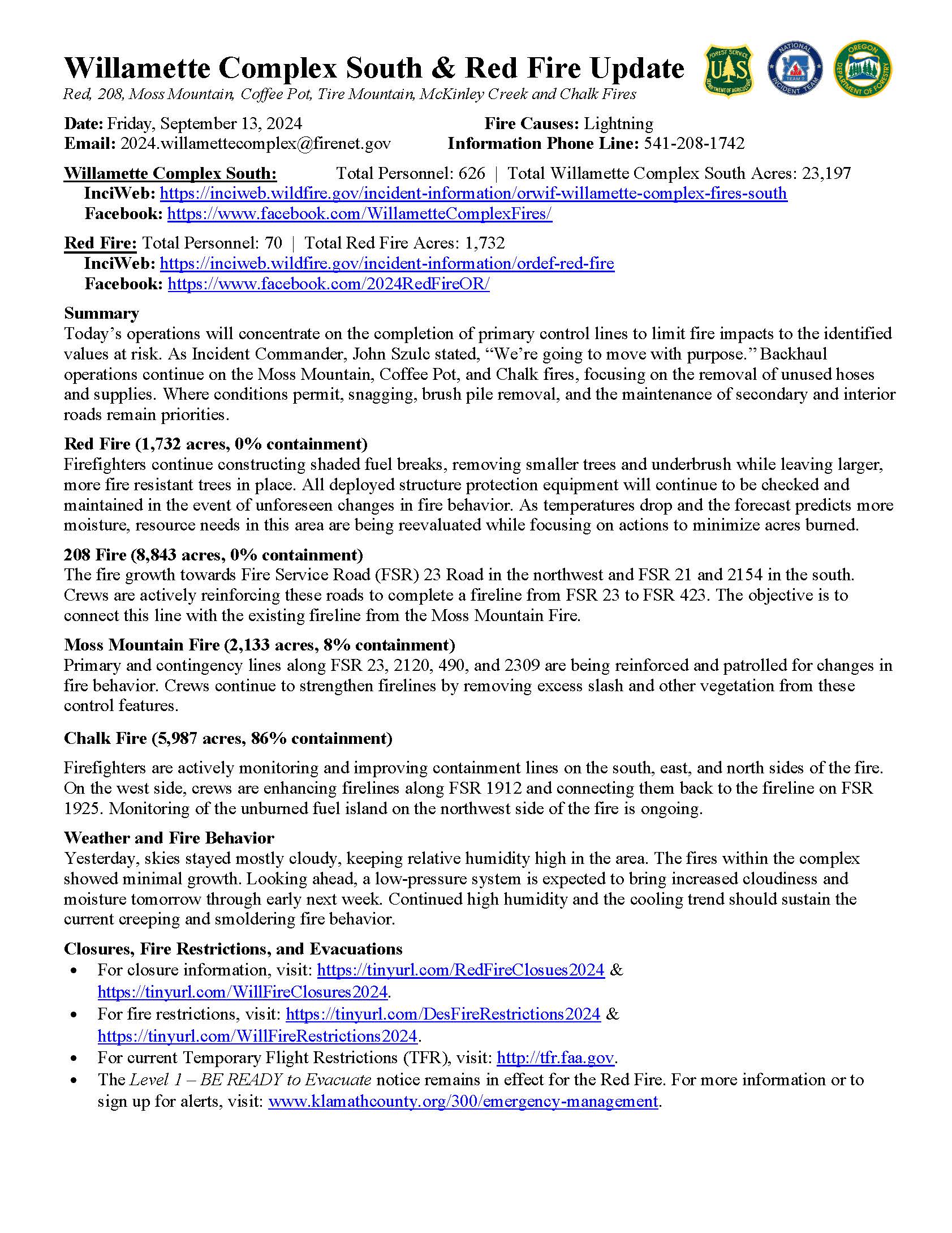
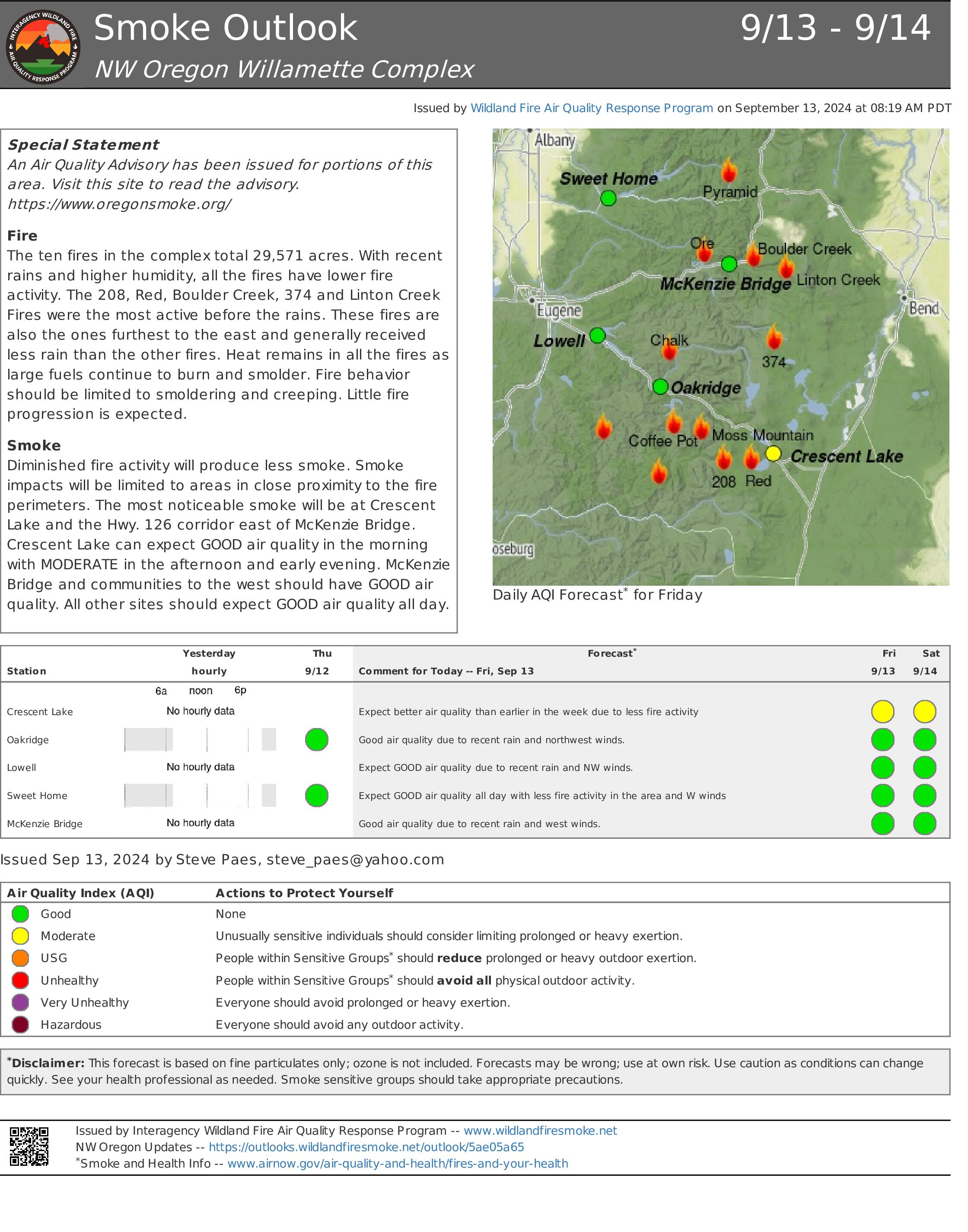
Willamette Complex South Daily Update for Friday September 13 2024 09 13 2024
Related Incident: Willamette Complex Fires - South
Publication Type: News
Willamette Complex South & Red Fire Update
Red, 208, Moss Mountain, Coffee Pot, Tire Mountain, McKinley Creek and Chalk Fires
Date: Friday, September 13, 2024
Fire Causes: Lightning
Email: 2024.willamettecomplex@firenet.gov
Information Phone Line: 541-208-1742
Willamette Complex South: Total Personnel: 626 | Total Willamette Complex South Acres: 23,197
InciWeb: https://inciweb.wildfire.gov/incident-information/orwif-willamette-complex-fires-south
Facebook: https://www.facebook.com/WillametteComplexFires/
Red Fire: Total Personnel: 70 | Total Red Fire Acres: 1,732
InciWeb: https://inciweb.wildfire.gov/incident-information/ordef-red-fire
Facebook: https://www.facebook.com/2024RedFireOR/
Summary
Today’s operations will concentrate on the completion of primary control lines to limit fire impacts to the identified values at risk. As Incident Commander, John Szulc stated, “We’re going to move with purpose.” Backhaul operations continue on the Moss Mountain, Coffee Pot, and Chalk fires, focusing on the removal of unused hoses and supplies. Where conditions permit, snagging, brush pile removal, and the maintenance of secondary and interior roads remain priorities.
Red Fire (1,732 acres, 0% containment)
Firefighters continue constructing shaded fuel breaks, removing smaller trees and underbrush while leaving larger, more fire resistant trees in place. All deployed structure protection equipment will continue to be checked and maintained in the event of unforeseen changes in fire behavior. As temperatures drop and the forecast predicts more moisture, resource needs in this area are being reevaluated while focusing on actions to minimize acres burned.
208 Fire (8,843 acres, 0% containment)
The fire growth towards Fire Service Road (FSR) 23 Road in the northwest and FSR 21 and 2154 in the south. Crews are actively reinforcing these roads to complete a fireline from FSR 23 to FSR 423. The objective is to connect this line with the existing fireline from the Moss Mountain Fire.
Moss Mountain Fire (2,133 acres, 8% containment)
Primary and contingency lines along FSR 23, 2120, 490, and 2309 are being reinforced and patrolled for changes in fire behavior. Crews continue to strengthen firelines by removing excess slash and other vegetation from these control features.
Chalk Fire (5,987 acres, 86% containment)
Firefighters are actively monitoring and improving containment lines on the south, east, and north sides of the fire. On the west side, crews are enhancing firelines along FSR 1912 and connecting them back to the fireline on FSR 1925. Monitoring of the unburned fuel island on the northwest side of the fire is ongoing.
Weather and Fire Behavior
Yesterday, skies stayed mostly cloudy, keeping relative humidity high in the area. The fires within the complex showed minimal growth. Looking ahead, a low-pressure system is expected to bring increased cloudiness and moisture tomorrow through early next week. Continued high humidity and the cooling trend should sustain the current creeping and smoldering fire behavior.
Closures, Fire Restrictions, and Evacuations
- For closure information, visit: https://tinyurl.com/RedFireClosues2024 & https://tinyurl.com/WillFireClosures2024.
- For fire restrictions, visit: https://tinyurl.com/DesFireRestrictions2024 & https://tinyurl.com/WillFireRestrictions2024.
- For current Temporary Flight Restrictions (TFR), visit: http://tfr.faa.gov.
- The Level 1 – BE READY to Evacuate notice remains in effect for the Red Fire. For more information or to sign up for alerts, visit: www.klamathcounty.org/300/emergency-management.
Coffee Pot Fire Daily Update 09 13 2024
Related Incident: Coffee Pot Fire
Publication Type: News
Unified Command: CAIIMT15 & CAL FIRE
Fire Size: 14,071 acres
Percent Contained: 59%
Primary Strategic Control Line: 96%
Personnel: 894
Cause: Lightning
Start Date: Saturday, August 3, 2024, at 10:05 a.m.
Location: Southeast of Three Rivers, CA
CURRENT SITUATION: Yesterday, construction of direct control line continued in the rugged terrain near the confluence of Horse Creek and the East Fork Kaweah River; helitankers dropped retardant to lower the fire’s intensity, while hotshot crews worked to build handline. The cooler temperatures and reduced winds helped to moderate fire behavior, with most of the remaining activity focused in the Eden Creek drainage with little threat to control lines. On the remainder of the fire perimeter crews continued to work on road rehabilitation, chipping, and mop-up operations.
Today, firefighters will continue direct control line construction in the northeast section of the fire. Aircraft will support their efforts with retardant drops as directed. Crews working around the remainder of the fire lines will continue to focus on mop-up and backhaul; removing hose, pumps, and other equipment that are no longer needed. Crews will work east along Mineral King Road toward Silver City reducing roadside vegetation and developing contingency lines.
WEATHER: The weather system that had previously impacted the area is now moving off to the northeast, while another system is approaching. As a result, temperatures will rebound slightly, similar to what was experienced on Wednesday, bringing near-normal conditions for this time of year. Expect slightly lower afternoon relative humidity levels, with winds and sunny conditions remaining consistent. Mixing heights are expected to increase, which will lead to better smoke dispersion across the region.
SMOKE IMPACTS: With moderate fire behavior, smoke impacts have reduced. GOOD air quality can be expected throughout the outlook area. Hammond will see MODERATE air quality conditions this morning, clearing to GOOD this afternoon. All other areas can expect GOOD air quality throughout the day, unless fire activity increases. For more information on current wildfire smoke impacts in your community, please visit AirNow.gov or fire.airnow.gov.
EVACUATION NOTICES: The Tulare County Fire Department has issued Evacuation WARNINGS for zones TLC-E094-B, TLC-E094-C, TLC-E094-D, TLC-E094-E, and TLC-E095. To find your zone, please refer to: protect.genasys.com.
FIRE INFORMATION: A Public Information Officer will be at the Three Rivers Village Market daily from 10:30 a.m. to 4 p.m. to provide fire information and answer questions.
BLM AND PARK CLOSURES: The portion of South Fork Drive within Sequoia and Kings Canyon National Parks and trails accessed from the road, including the Ladybug and Garfield Grove Trails, are closed. Recreational access to the Mineral King area of Sequoia National Park is closed to the public. This applies to Mineral King campgrounds, trailheads, and area trails. All other areas of the parks are open but are likely to be impacted by varying levels of smoke and poor air quality. Park closure information is available online at nps.gov/seki. The Bureau of Land Management has also issued a closure of the Case Mountain Extensive Recreation Management Area at blm.gov/press-release.
PUBLIC NOTICE: Wildfires are a no-fly zone for unauthorized aircraft, including drones. If you fly, we can’t. For more information, visit knowbeforeyoufly.org.
Lava Fire Daily Update September 13 2024 09 13 2024
Related Incident:
Publication Type: News
Friday September 13, 2024
*** There will be a Community Meeting this evening, Friday September 13th at 7:00 PM at the Ola Community Center 2175 Main Street, Ola, ID***
Overview: The Lava Fire is on the Boise and Payette National Forests and lands administered Bureau of Land Management and the Idaho Department of Lands. The fire is located north of Emmet and west of Lake Cascade and started by lightning on Monday, September 2nd and is burning in tall grass, brush, and timber.
The Lava Fire is currently 94,589 acres with 6 percent containment and 746 personnel assigned.
Any property remaining in an area that is either evacuated or impacted by Forest Service closures will need to remain in place until fire managers and Sheriff’s departments deem the area is safe for reentry.
Operations: Yesterday, structure protection prioritized God’s Acres Subdivision and The Church Camp. Crews installed lines connecting with natural unburnable features to secure structures. The fire is burning slowly in the previous Four Corners Fire scar of 2022 near Hazard Creek and Lookout Peak. Lava Fire personnel and equipment supported a new initial attack response five miles south of Lake Cascade. Fire was controlled at one quarter of an acre. Firefighters escorted communication companies to telecommunication towers to inspect and repair equipment and local ranchers were escorted to Hwy 618 to retrieve their stock from the fire area.
On the western flank of the fire, crews began mopping up on dozer lines east of Indian Valley Road, North Crane Road, and Spring Creek.
Night shift crews patrolled and monitored fire activity ready to respond to any concerns.
Today, fire suppression activities include handlines, dozer lines, and using natural features for containment lines around the fire perimeter.
On the northern flank, personnel are scouting location for direct perimeter containment. Structure protection personnel will continue structure assessments in God’s Acres Subdivision, the Church Camp, and Tamarack Ski Resort.
On the eastern flank, firefighters are mopping up dozer lines on Forest Service Road 404 and Willow Creek. Crews continue mop up along the fire perimeter north of Boulder Creek. Continue the structure assessments and structure protection around Lake Cascade.
On the southern flank, structure protection priority is on Third Fork, Nesbitt, and 653 Roads. Personnel scouting line construction from the 601 Road to the north. Initial attack resources are mopping up the new start from yesterday.
Along the western flank, fire personnel are constructing a continuous containment line northward to Little Weiser River Road. Firefighters will mop up and extinguish areas of heat near the fire edge as they move north, protecting the range allotments, grasslands, and private property outside the fire perimeter.
Weather/Fire Behavior: Yesterday, a cloudy sky and isolated rain showers moved across the fire area with precipitation up to three quarters of an inch. Lower temperatures and higher humidity resulted in minimal fire activity and allowed firefighters to effectively mop up areas where heat persisted. A drying trend begins today with higher temperatures and lower humidity. Fuels will lose the moisture gained through these rain events, creating the potential for increased fire activity.
Evacuations and road closures:
Adams County Sheriff’s Office issued a LEVEL 3 “GO!” Evacuation notice to residents south of South Grays Creek and along Little Weiser Road in Indian Valley. A LEVEL 2 “SET” Evacuation has been issued for residents North of South Grays Creek Road to Highway 95, and a LEVEL 1 “READY” Evacuation has been issued for the Mesa area.
Gem County Sheriff’s Office issued a LEVEL 3 “GO!” Evacuation notice to residents on Third Fork Road (North of Nesbitt Lane), Second Fork Road (North of Nesbitt Lane), and the Sage Hen Reservoir area. Gem County Sheriff’s Office notified the residents in person on September 8th, 2024. A LEVEL 2 “SET” Evacuation has been issued for Nesbitt Lane residents.
Gem County Road and Bridge issued the following road closures: Third Fork Road at Nesbitt Lane, Second Fork Road at Nesbitt Lane, and Nesbitt Lane. The Sweet-Ola Highway is closed at the High Valley intersection in Ola. Please be advised that the Gem County Sheriff’s Office is staffing the road closure check points.
Valley County Sheriff’s Office has downgraded zones 4, 5, 6 to a “Set” status, effective as of 9/12/2024 at 10:15 AM. Zones 7 – 11 remain in their current unchanged in a “Set” status.
Forest Closures and Restrictions: The Boise and Payette National Forests implemented a joint Lava Fire Area, Road, and Trail Closure for public and firefighter safety. The closure includes Forest Service lands north of the 601 Road (approximately 7 miles southwest of Smiths Ferry) and north all the way to the northernmost extent of Lake Cascade. This expanded closure order supersedes previous closure orders and will be in place through December 31, 2024 unless rescinded.
A temporary flight restriction is in effect in and around the fire area. This includes the use of personal drones. If you fly, we cannot fly.
Willamette Complex North Daily Update 09 13 2024
Related Incident: North Willamette Complex
Publication Type: News
Willamette Complex North Update
Boulder Creek, Ore, Linton Creek, Pyramid, 374, and Roundtop fires
Date: Friday, September 13, 2024
New Willamette Complex North Facebook Page: https://www.facebook.com/profile.php?id=61565845313387
Email: 2024.WillametteComplex.North@firenet.gov Information line: 541-208-1262 Hours: 8 a.m. to 8 p.m.
Overview: Clearer skies increase the ability for firefighters to go direct with the support of aircraft providing water drops. The Boulder Creek Fire remains the top priority. A road closure continues for a section of OR 242, and a portion of OR 126 remains closed while conditions are evaluated for safety. Today will be much drier and warmer with high temperatures around 75 in much of the complex with light winds. Fires in the complex had minimal growth overnight. Precise mapping on some of the fires is limited due to recent clouds and rain. Fire-impacted trees are a significant safety risk across the complex for fire crews and the public, with increased fire behavior expected.
Boulder Creek Fire Evacuation Notices
LEVEL 3 (GO NOW) EVACUATION NOTICE: Scott Creek Road
LEVEL 1 (BE READY) EVACUATION NOTICE:
South of Highway 126 from milepost 53.5 east to Scott Creek Road and Horse Creek Road east of Foley Springs, Foley Springs, Forest Service Road #302, Belknap Springs Road South, Camp Yale Road, Yale Lane, North of Highway 126 East from the east end of Drury Lane to the end of North Belknap Springs Road
Evacuation Notice Source: Visit www.LaneCountyOR.gov or use this link.
Boulder Creek: 501 acres, 0% contained
Located 5 miles east of McKenzie Bridge. Structure protection work is near completion with areas around cabins cleared of easily ignited fuels. Crews are going direct on the fire where safe and taking advantage of the recent rain to find opportunities.
Ore: 3,461 acres, 44% contained
Located 7 miles northeast of Blue River. Chipping and removal of fuels continues. Successful firing operations were completed and will be expanded as conditions allow.
Linton Creek: 1,288 acres, 0% contained
Located in the Three Sisters Wilderness northeast of Eileen Lake. Clear air will likely provide opportunity for crews to better access the fire. Structures in the area are being evaluated. Ground and aerial firefighting will continue.
Pyramid: 1,311 Acres, 98% contained
East of Middle Santiam Wilderness. Securing containment line continues with chipping of burnable fuels.
374: 47 acres, 0% contained
This fire is also in the Three Sisters Wilderness, northwest of Packsaddle Mountain. 14 smokejumpers are assigned to the fire with the goal of keeping the fire as small as possible by working on control lines near the fire.
Roundtop: Near the 374 Fire and Little Roundtop Mountain. It was kept at a quarter acre and fully contained.
Road Closures: Due to the Boulder Creek Fire, OR 126 is closed between mileposts 13 and 19.5 (intersection with OR 242). OR 242 remains closed to all traffic indefinitely between the intersection with OR 126 and the Dee Wright Observatory (mileposts 55 to 75), in the area of the Linton Creek Fire. Use an alternate route; do not divert onto forest roads to avoid closures. Check for updates at: https://tripcheck.com/
Willamette National Forest Area Closures: Due to increased fire activity in the McKenzie River Ranger District, the Linton Creek Fire closure area was expanded to include Boulder Creek, 374, Roundtop, as well as other fires on the Middle Fork Ranger District including Young Grasshopper and Lowell Creek fires. Source: https://www.fs.usda.gov/detail/willamette/alerts-notices/?cid=fseprd552029.
###
Wood Lake Fire Update for September 13 2024 09 13 2024
Related Incident:
Publication Type: News
Wood Lake Fire Update
Date: September 13, 2024 Size: 17 acres Containment: 0%
Cause: Under Investigation Start Date: September 10, 2024
Fire Information:
Inciweb page: https://inciweb.wildfire.gov/incident-information/mnsuf-wood-lake-wildfire
Superior NF Facebook: https://www.facebook.com/SuperiorNF
Twitter/X: https://x.com/SuperiorNF
Sign up for Superior NF Fire Information notices and news
Current Status and Resources: Fire acreage increased yesterday along the southeast perimeter due to
firing operations aimed at strengthening the fire’s edge. Firefighters continue to suppress the
fire, strengthen fire holding lines and use natural fire breaks such as wetlands when possible.
Aircraft are being used to cool the fire and initiate suppression actions with the highest likelihood of success; however, increased fire weather remains elevated statewide and aerial resources may be limited. The National Preparedness Level remains at 5.
Planned Actions: Resources are planning for a potentially active fire day from forecasted increased
winds and continued drying weather. Resources will continue to strengthen containment lines with a
variety of tools including utilizing pumps and hose lays, using natural features, and using
backfiring through hand ignition when needed to reduce spotting potential near the perimeter or
containment line. Additionally, firefighters will be looking at contingency planning around the
Moose Lake area today to analyze and plan that wider perimeter area around the fire.
Closures: The Superior National Forest implemented Emergency Closure Order #09-09-24-07 for the
public’s health and safety due to the Wood Lake fire within the vicinity of recreation areas. The
closure order includes Exhibit A-List of Closed Areas and Exhibit B-Closure map.
Weather and Smoke: Today-mostly sunny with a high near 78. South winds 5-15 mph with gusts up to 20
mph. Overnight-Partly cloudy. Low of 59. Southeast wind at 5 mph, with gusts up to 15 mph.
Saturday-A chance of showers with thunderstorms possible aft 1pm. Partly sunny. High of 76. South
wind 5-10 mph, with gusts up to 15 mph. 30% chance of precipitation. Elevated burning conditions
continue into the weekend.
Overall air quality in the Ely area will be MODERATE today. Wildfire smoke from Canada is also
present in the area. https://www.airnow.gov/and https://www.pca.state.mn.us/air-water-land-
climate/air-quality-forecast
Fire Summary: On Tuesday, September 10, 2024, around 11:00 a.m. a fire was detected on an island of
Wood Lake, which is located north of County Road 18, within the Boundary Waters Canoe Area
Wilderness (BWCAW) of the Superior National Forest (NF). The fire is located in Township 64, Range
10, Section 26 on National Forest System land. An Emergency Closure Order wis in effect for 19
locations including BWCAW Entry Point 26 on Wood Lake.
Bridge Fire Community Meeting at Serrano High School on 09 14 2024
Related Incident: Bridge Fire
Publication Type: Announcement
Bridge Fire Community Meeting
Saturday, September 14, 2024
6:00 - 8:00 p.m.
Serrano High School Performing Arts Center
9292 Sheep Creek Rd. Phelan, CA 92371
The meeting will also be live-streamed on the Angeles National Forest Facebook page:


Davis Fire Update 09 13 2024
Related Incident: Davis Fire
Publication Type: News
Southwest Area Incident Management Team Update for Wednesday, September 13, 2024
Acres: 5,824 acres
Start Date: 09/07/2024
Location: Washoe Valley, Nevada
Personnel: 685
Containment: 56%
Fuels: Timber
Resources: 10 Crews | 14 Helicopters | 71 Engines | 5 Water Tenders | 4 Dozers
Highlights: Crews continued reinforcing existing fire lines, completing approximately 2,000 feet of handlines near Slide Mtn. Five to ten acres of unburned fuel pockets (islands) were intentionally burned near Winter Creek Rd. to eliminate flammable materials like leaves, pine needles, and small limbs. Isolated areas of large logs and stumps, or ‘heavies,’ are still smoldering and producing light smoke. Additional containment was secured along the fire perimeter. Aviation resources will remain available today. Water tenders and portable tanks have been strategically placed to strengthen firefighting efforts.
Smoldering and creeping fire activity is expected, with isolated pockets of smoke still visible. Firefighters will continue mop-up efforts, working over 100 feet inside the fire lines. The fire lines are dozer lines, handlines and existing road systems. Mop-up operations will focus on all areas where heat is detected, with particular attention along the fire perimeter near Davis Creek Rd, progressing northwest past Hidden Lake and up to Mt. Rose Highway. Mop-up includes extinguishing hot spots with water, stirring burning vegetation with hand tools, and trimming lower limbs to prevent the fire from reaching the tree canopies. Crews will patrol fire lines to ensure embers remain contained and will remove any hazardous, burned trees at risk of falling across fire lines or roads.
Weather: Forecast warmer and drier conditions for today. The relative humidity is expected to drop down into the teens. Winds will be primarily out of the east, but also affected by the steep slopes (terrain driven). Expect breezy conditions over the weekend. Temps will be in the mid-80s on Saturday and dropping down to the mid-70s on Sunday.
Evacuations: We urge everyone to remain vigilant and stay clear of evacuation zones. Stay informed by relying on official fire information sources.For updates on evacuation statuses please visit: https://perimetermap.com
To sign up for code red alerts and warning visit https://www.washoecounty.gov/em/RegionalAlerts.php