
Shoe Fly Fire Morning Update 09 14 2024
Related Incident: Shoe Fly Fire
Publication Type: News
Firefighters push toward completion of mop up
MITCHELL, Ore. – Mop up on the Shoe Fly Fire is near completion. Firefighters have reached 300 feet of cold black adjacent to the perimeter on much of the 26,774 acre fire, resulting in an increase of containment to 77%.
Today, firefighters will continue to mop up heavier fuels in the Gird’s Creek area on the southwest flank and around Baldy Mountain on the northeast corner of the fire. These areas have timber and larger fuels that hold heat longer and require more water and effort to extinguish. A drone with infrared capabilities will be used in the northeast corner of the fire to locate hot spots, speeding up the mop up process.
Bridge Fire Evening Update 09 14 2024
Related Incident: Bridge Fire
Publication Type: News
Unified Command: CIIMT5, Los Angeles County Fire, Los Angeles County Sheriff, San Bernardino County Fire, San Bernardino County Sheriff, CAL FIRE – San Bernardino/Inyo/Mono Unit
Start Date: September 8, 2024, at 2:12 p.m.
Fire Information: (626) 470-0120 ***Original number***
Media Line: (626) 470-1395
Hours: 7:00 a.m. to 9:00 p.m.
Email: 2024.Bridge@firenet.gov
Fire Size: 53,779 acres
Percent Contained: 5%
Personnel: 2,625
Injuries: 2
Cause: Under investigation
Location: Sheep Mountain Wilderness, San Gabriel Mountains National Monument
CURRENT SITUATION: Today firefighters continued establishing and strengthening direct containment lines while also constructing secondary contingency lines with dozers and hand crews. Several helicopters working the hottest areas helped firefighters make progress, and additionally responded late this afternoon in an assist for containing a new fire start in the Lytle Creek area.
The northwest corner of the fire was most active today. Air operations plans to install a mobile retardant base tonight in that area to aid firefighters in directly attacking it aggressively with night-flying helicopters. Although interior “islands” of unburned vegetation remain in the northern part of the fire, firefighters also plan to go direct and continue holding and securing their containment lines to protect the community of Wrightwood, Pinon Hills and beyond. To the northeast, the fire has reached drainages on the west side of the north fork of Lytle Creek, however firefighters are prioritizing dozer lines and direct attack wherever possible to stop the fire’s spread.
The east side of the fire is less active, however still presenting risks to residents in the Mt. Baldy area so evacuation orders remain in effect. Structure defense groups remain in place throughout the day and night to mitigate any isolated heat and continue the progress made by the previous operating shift.
On the south side, firefighters are still holding their containment line at Sunset Peak area while they continue contingency line construction below it. This area of the fire is where they were able to increase containment percentage by 2 percent.
In the rugged and steep terrain of the Sheep Mountain Wilderness below Mount Baden-Powell, firefighters gained entry in three main locations to construct dozer line and hand lines while aircraft assisted them with extinguishing hotspots.
This afternoon, damage inspection teams released interactive maps for local residents affected by the Bridge Fire. For San Bernardino County visit: https://prepare.sbcounty.gov/bridge-fire/. For Los Angeles County visit: https://recovery.lacounty.gov/bridgefire/.
The next public meeting is scheduled for Monday, September 16 at Lytle Creek Community Center, 14082 Center Rd., San Bernardino, CA at 7:00 p.m. It will also be live streamed via the new Angeles NF Fire Info YouTube page.
Evacuation Orders:
- Mt. Baldy Road, North Mountain Avenue and Shinn Roads from San Antonio Heights to Wrightwood and east to Cucamonga Peak
- Hwy 138 south to Lone Pine Canyon and Highway 2 east to Lone Pine Canyon Road.
- The community of Wrightwood.
- Lone Pine Canyon Road south to the forest.
- East Fork communities of Camp Williams Resort (café, mobile home park, campground) and River Community (near the resort).
Evacuation Warnings:
- West Cajon area of Highway 138 south to Lytle Creek and Oil Well Road East to Stone Basin
- San Antonio Heights and Upland from the foothills south to 23rd Street.
- Piñon Hills from Wrightwood north to Highway 138 and Lebec Road west to Los Angeles County.
- For evacuation warnings in San Dimas, La Verne, and Claremont please visit: Genasys Protect
“Know Your Zone” by visiting the Genasys Protect website or download the app. Protect.genasys.com
If not already registered for emergency alerts, please register here:
- Los Angeles County: https://ready.lacounty.gov/emergency-notifications/
- San Bernardino County: https://wp.sbcounty.gov/sheriff/alerts/
Evacuation Centers:
- San Bernardino County Fairgrounds: 14800 Seventh Street, Victorville, CA
- Jessie Turner Health/Fitness Center: 15556 Summit Ave, Fontana, CA. (909) 854-5100
- Pomona Fairplex: 601 W McKinley Avenue Pomona, CA (Gate 3, corner of McKinley/White)
- Antelope Valley Fairgrounds: 2551 W Avenue H, Lancaster, CA
Animals:
- Devore Animal Shelter: 19777 Shelter Way, San Bernardino, CA. (909) 386-9820. After hours: (800) 472-5609
- Palmdale Animal Care Center (Small Animals): 38550 Sierra Hwy, Palmdale, CA
- Lancaster Animal Care Center (Small Animals): 5210 W Ave I, Lancaster, CA
- Antelope Valley Fairgrounds (Large Animals): 2551 W Avenue H, Lancaster, CA. Call (562) 706-8581
For more information on shelters, visit:
- www.redcross.org/get-help/disaster-relief-and-recovery-services/find-an-open-shelter.html
- https://lacounty.gov/emergency/
CLOSURES:
- SR-138 from Lone Pine Canyon Road to Beekley Road
- SR-2 closed from Big Pines to SR-138
- Big Pines Highway
- Big Rock Creek Road
- San Gabriel Canyon and East Fork of the San Gabriel River
- Highway 39
- East Fork Road
- Glendora Ridge Road and Glendora Mountain Road
- Mt. Baldy Road at Shinn Road intersection
WEATHER:
High humidities are expected tonight, with stronger southwest winds at the heel of the fire. Northwest winds will push down on the fire from the north side. Sunday will see cooler temperatures as well with a significant cold front dropping approximately 1/10 inch of rain and snow above 9,000 feet. Winds will switch from the southwest to the northeast on Sunday, testing containment lines on this fire. Favorable winds, temperatures, and humidity will continue until Thursday, however dry and hot conditions will start again this Friday.
For smoke impacts and an interactive map, visit fire.airnow.gov.
FIRE RESTRICTIONS IN OPEN AREAS OF ANGELES NATIONAL FOREST:
The Fire Danger on the Angeles National Forest is now “Extreme” Angeles National Forest - News & Events (usda.gov)
Additional Information Resources:
Updated Fish Creek Fire Area Road and Trail Closure Order 040324312 09 13 2024
Related Incident:
Publication Type: Closures
U.S. Department of Agriculture, U.S. Forest Service Bridger-Teton National Forest
Jackson & Blackrock Ranger Districts Shoshone National Forest
Wind River District
Fish Creek Fire Area, Road, and Trail Closure
The Fish Creek Fire is burning 7-miles southwest of Togwotee Pass. https://inciweb.wildfire.gov/incident-information/wybtf-fish-creek-fire. The described area, road, and trail closure order is in effect:
Bridger-Teton National Forest Fish Creek Fire Closure area boundary begins where it meets the SW corner of Shoshone National Forest Fish Creek Fire area boundary that abuts the Continental Divide and Bridger-Teton National Forest boundary, at the boundary of Sections 22 and 27, T43N R110W. Continuing W along the section line for approximately 3 miles until the intersection of the FS RD 30750 and then southwesterly along said road (North Fork of Fish Creek) to its intersection with FS RD 30800 then northerly along said road (Cottonwood Creek) to a point approximately ½ mile due east of the confluence of Elkhorn Creek and Cottonwood Creek, due west along this bearing to the confluence of Elkhorn Creek and Cottonwood Creek, then northwesterly along Elkhorn Creek to the hydrologic divide, then southwesterly then north and northwesterly to Mt. Leidy, then northeasterly along the hydrologic divide to its intersection with the South Fork Spread Creek Road (30100) , then northerly along the same road to its intersection with Hatchet Road (30160), then following and including Flagstaff Road (30100) east to its intersection with US Highway 26/287. North across highway 26/287 to the hydrologic divide on Angle Mountain. East along the hydrologic divide to its intersection with the Continental Divide in the center of Section 22 T44N R110W.
The Shoshone National Forest Fish Creek Fire Closure area boundary begins at the SE corner of the Bridger-Teton National Forest Fire closure area. Continuing E along the N side of the section line dividing T43N R110W Sections 27 and 22 to Forest Service Road (FS RD) 540. The closure area continues NW on the W side of FS RD 540 to the intersection with FS RD 540.1D. Continuing NW along the W side of FS RD 540.1D to the intersection with FS RD 540.1E, the closure continues NW on the W side of FS RD 540.1E to the W side of Pelham Lake Creek. Extending E on the NW side of Pelham Lake Creek to the confluence of the Wind River, the closure crosses the Wind River to the private property boundary. At the private property boundary, the closure continues N then E on the W side of the property boundary to Highway (HWY) 26/287 and resumes on the NE side of HWY 26/287. In a SE direction, the closure extends to FS RD 513. The closure continues E on the N side of FS RD 513 to the W side of the section line dividing T43N R109W sections 27 and 26. Continuing N along said section line, the closure extends to the Dunoir Special Management Area (SMA) boundary and continues NW along said boundary to the Continental Divide. The closure continues W and SW along the S side of the Continental Divide until it meets the Blackrock RD boundary. The closure connects with the NE corner of the Bridger-Teton National Forest Fire closure area.
The Described Roads and Trails include the following NFS roads and trails located within and bordering the Described Area:
1. Portion of NFS Road 30750 (Moccasin Basin Road), to its intersection with NFS Rd 30800.
2. Forest Road 30100 (Flagstaff/South Fork Spread Creek Road) in its entirety.
3. Forest Road 30200 (Mary’s Lake) in its entirety.
4. Forest Road 30234 (Nation Creek) in its entirety.
5. Forest Road 30250 (Leidy Lake) in its entirety.
6. Forest Road 30800 in its entirety.
7. NFS Trail 30240 in its entirety.
8. FS RD 30120 (North Fork Spread Creek) in its entirety.
9. FS RD 30140 (Grizzly Creek) in its entirety.
10. FS RD 30010 (Two Ocean Basin) in its entirety.
11. NFS Trail 4079 (Cottonwood Creek Trail), in its entirety.
12. NFS Trail 4106 (Spruce Creek Trail), in its entirety.
13. NFS Trail 6107 (Two Ocean Basin Trail) in its entirety.
14. NFS Trail 6071 (South Fork Spread Creek) in its entirety.
15. NFS Trail 6057 (portion of Holmes Cave Trail south of the hydrologic divide of Angle Mountain.
Shoshone National Forest:
3. Falls Campground Road
4. FS RD 515 in its entirety
5. FS RD 521 in its entirety
6. FS RD 522 in its entirety
7. FS RD 537 in its entirety
8. That portion of FS RD 540 north of its junction with FS RD 540.1D
9. FS RD 540.1A in its entirety
10. That portion of FS RD 540.1E northwest of Pelham Lake Creek
11. FS RD 645 in its entirety
12. MT10 in its entirety
13. North of FS RD 513
14. FS RD 549 in its entirety
15. FS RD 548 and all roads that originate from said road
16. FS RD 548.1D in its entirety
17. FS RD 649 in its entirety
18. FS RD 585 in its entirety
19. FS RD 589 in its entirety
20. FS RD 590 in its entirety
21. FS RD 591 in its entirety
22. FS Trail 807.1A Pinnacles Trail
23. FS Trail 823.1B Bonneville Pass Trail
24. FS Trail 823 Bear Cub Pass Trail
25. FS Trail 823.1A Jade Lakes Trail
26. FS Trails 823.1C Rainbow Lake Trail
27. FS Trail 823.1E Sublette Pass Trail
Rescinded Rogue RiverSiskiyou Closure for Middle Fork Fire 09 14 2024
Related Incident: Middle Fork Fire
Publication Type: Closures
Per the Rogue River-Siskiyou National Forest's Facebook Page:
News Release: Middle Fork Fire Emergency Area & Road Closure Rescinded
Prospect Ore – September 13, 2024 — Rogue River-Siskiyou National Forest Supervisor Molly Juillerat is rescinding the Middle Fork Fire Emergency Area & Road Closure effective at 6:00 a.m. on Saturday, September 14, 2024, in cooperation with the Incident Management Team managing the Diamond Complex on the Umpqua National Forest. The closure is being rescinded as a result of significant progress made with fire operations. The public is reminded to use caution whenever traveling through recently burned areas, particularly on windy days when trees are more likely to fall. The closure was in effect until January 15, 2025 unless rescinded.
Temporary Closure Areas Decrease on Deschutes National Forest 09 14 2024
Related Incident: Bachelor Complex Fires
Publication Type: Closures
Deschutes National Forest has updated the temporary emergency fire closure areas on the Bend-Fort Rock Ranger District due to the Bachelor Complex. The Bachelor Complex includes Little Lava Fire, Backside Fire and multiple smaller fires.
All National Forest System Roads found within the area closure remain closed. Cascade Lakes Highway (NFSR 46), NFSR 41, and NFSR 42 are open for public use.
The full closure descriptions and map products for temporary emergency closures on the Deschutes National Forest are online at https://www.fs.usda.gov/alerts/deschutes/alerts-notices.
Johnson Fire Daily Update 09 13 2024
Related Incident:
Publication Type: News
Northern Rockies Team 5, Incident Commander Joe Sampson
Location:3 miles south of Springer Memorial Community, in the East Fork
Start Date: 7/25/2024
Cause: Lightning
Size: 6662 Acres
Completion: 25%
Total Personnel: 212
Current Status
Crews took shelter during the thunderstorms yesterday. Once storms subsided, crews were able to assess the impact of the rain on the fire and make operational plans for the coming days. A helicopter will be assisting crews to remove equipment off of the line today and over the weekend. Suppression repair on the fireline will likely begin this weekend. Crews will continue to patrol the west side of the fire, searching for residual heat.
Weather and Fire Behavior
Gusty winds are expected over the next few days with temperatures rising into the upper 60s over the weekend. The slight increase in temperatures and windy conditions will result in a higher likelihood of smokey conditions, with creeping and smoldering of larger fuels. By early next week, another low-pressure system will make its way through the area, bringing more wetting rain to the fire area.
EVACUATIONS, RESTRICTIONS, CLOSURES
- Area closures are in effect for both sides of the East Fork Road, the East Fork Guard Station, Martin Creek Campground, and a multitude of trailheads. More information on Bitterroot National Forest area closures can be found at: https://www.fs.usda.gov/alerts/bitterroot/alerts-notices
- The Anaconda-Pintler Wilderness within the Bitterroot National Forest is currently in Stage I Fire restrictions.
- The Temporary Flight Restriction (TFR) area was expanded on September 10th. More information can be found on the FAA website: https://tfr.faa.gov/save_pages/detail_4_2921.html
Johnson Fire Daily Update 09 14 2024
Related Incident:
Publication Type: News
Northern Rockies Team 5, Incident Commander Joe Sampson
Location:3 miles south of Springer Memorial Community, in the East Fork
Start Date: 7/25/2024
Cause: Lightning
Size: 6,679 Acres
Completion: 46%
Total Personnel:153
Current Status
Area closures surrounding the fire area are still in effect. These closures are necessary to protect the safety and welfare of the public and provide for safe firefighting operations and access. Fire managers are working in conjunction with Bitterroot National Forest officials to assess the need and potential boundary changes, shrinking the affected area within the closure.
Crews will be using an excavator to begin repair work on the equipment lines within the fire area. Firefighter focus will shift to repair work over the next week. Firefighters will work to remove remaining equipment off of the line. Crews will continue to patrol the west side of the fire, searching for pockets of residual heat. Temporary Flight Restrictions (TFRs) have been lifted over the fire area and are no longer in effect.
Weather and Fire Behavior
There will be a slight increase in fire conditions over the weekend. Temperatures will rise slightly and be in the 60s today and tomorrow. Relative humidities will also see somewhat of a drop to about 40 percent on mid-slopes. Winds up to 20 mph on ridgetops are possible. Late Monday another storm system is expected and will likely remain through Wednesday. This storm system could bring up to an inch of rain.
EVACUATIONS, RESTRICTIONS, CLOSURES
- Area closures are in effect for both sides of the East Fork Road, the East Fork Guard Station, Martin Creek Campground, and a multitude of trailheads. More information on Bitterroot National Forest area closures can be found at: https://www.fs.usda.gov/alerts/bitterroot/alerts-notices
- The Anaconda-Pintler Wilderness within the Bitterroot National Forest is currently in Stage I Fire restrictions.
Fossil Complex AM Update 09 14 2024
Related Incident: Fossil Complex
Publication Type: News
Drier Conditions Today On The Service Fire
SPRAY, Ore. – As fuels began to dry out yesterday afternoon, two spot fires became established outside of the fire lines. Ground and aerial resources responded and have reported that the spot fires are fully lined this morning. Crews also completed a survey of the perimeter of the unburned interior island that is about 700 acres in size and fire managers have developed a plan to secure the area without needing to burn the island. While this plan will require some extra effort, minimizing the acres burned to preserve landowner values is an incident objective.
Work along ORE 19 continues with chipping, hazard tree removal and mop-up. The public is reminded to use caution and slow down on the highway as crews and equipment are actively working. The west to northwest side of the fire is in mop up, with some areas having 100 feet of cool black. Around the north to northeast side of the fire the work will be laying hose and moving into the fire, cooling hot areas. To the east, crews will secure lines with tactical firing operations as conditions allow. The southern part will have crews continue their work building direct line and moving into the fire’s interior.
While today’s weather will be similar to yesterday, fuels are expected to dry and become available earlier in the day because moisture from the recent rains has evaporated.
The reported acreage of the fire changed yesterday because more accurate infrared mapping of the fire perimeter became available.
Videos: Recordings of the Daily Operations Updates and other stories are available at: https://www.youtube.com/@FossilComplex.
Evacuation: Level 3 evacuations remain inside the perimeter of the Service Fire. For the most recent evacuation levels please go to: https://www.facebook.com/WheelerCountySheriffsOffice/
The Two Cabin, Holmes, Kinzua and Canyon Fires are all in patrol status.
Bridge Fire Announcement 09 14 2024
Related Incident: Bridge Fire
Publication Type: Announcement
Field damage inspections for the Bridge Fire are ongoing and subject to change, as information is gathered and verified. The icons on the map indicate the current known status of the structure.
Addresses may be entered into the search bar to find a specific location.
Please be advised that a majority of the residential inspections in both Mt. Baldy Village and Wrightwood have been completed.
The majority of remaining inspections are outside of those areas.
For recovery support and information visit:
San Bernardino County Recovery Information
https://prepare.sbcounty.gov/bridge-fire/
Los Angeles County Recovery Information
https://recovery.lacounty.gov/bridgefire/
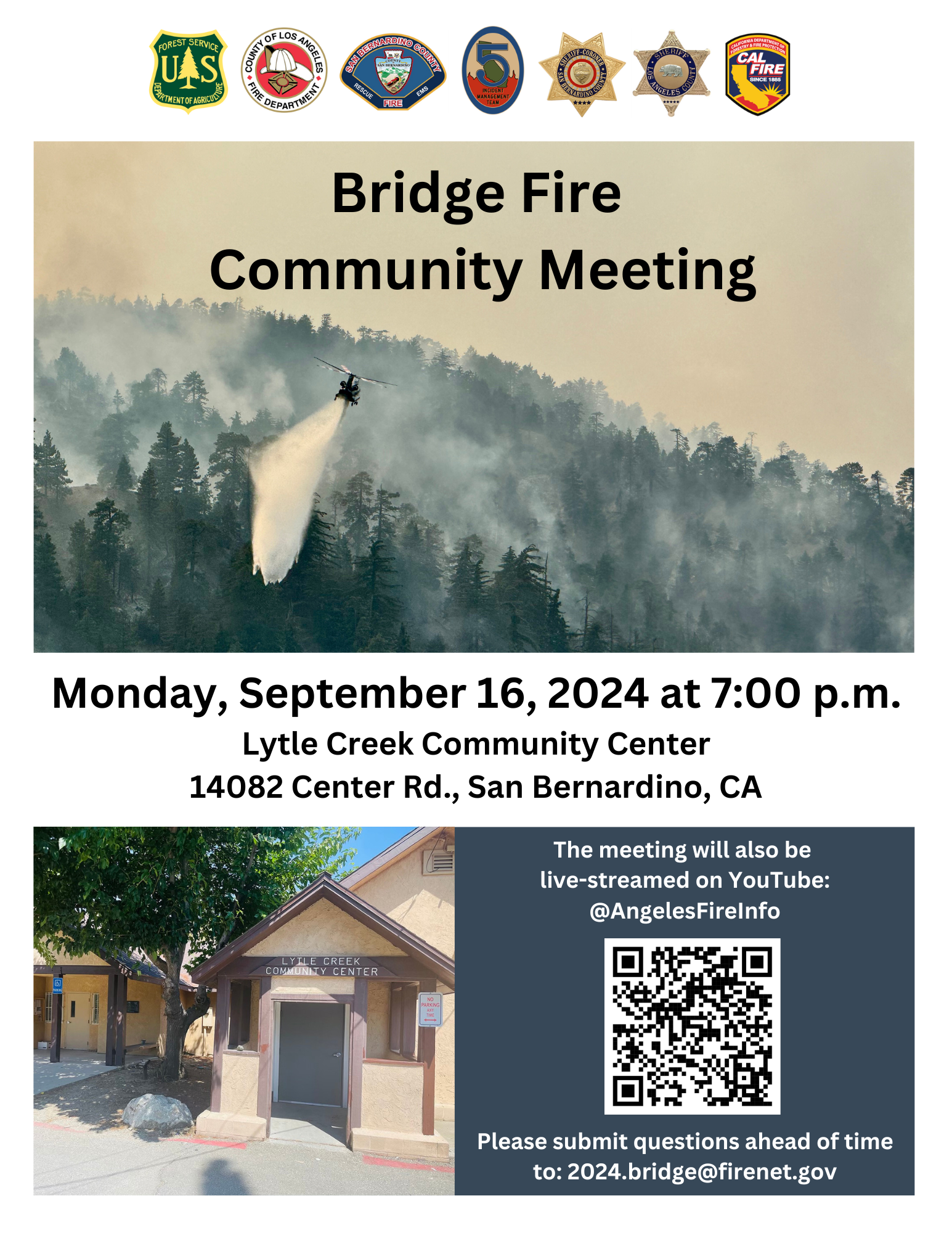
Bridge Fire Lytle Creek Community Meeting Sept 16th 09 14 2024
Related Incident: Bridge Fire
Publication Type: Announcement
The Unified Incident Command Team will be hosting a community meeting on Monday, September 16, 2024 at 7:00 p.m.
Location: Lytle Creek Community Center 14082 Center Rd., San Bernardino, CA
The meeting will also be live-streamed on YouTube: @AngelesFireInfo Please submit questions ahead of time to: 2024.bridge@firenet.gov